Runswick Bay is a highly regarded Yorkshire Coast locality, known for its diverse ammonite fauna and productive foreshore exposures. Under the right conditions, the bay can yield a wide range of ammonite species along with bivalves and other marine fossils, often found loose or within nodules. With its broad beach and regular fresh material from erosion, it can be a very rewarding site for collectors.


FIND FREQUENCY: ♦♦♦ – Most fossils are found by splitting rocks using a hammer. They can also be found within rocks along the foreshore.
CHILDREN: ♦♦♦♦♦ – This location is recommended for families, as it is easy to access the shore.
ACCESS: ♦♦♦ – There is a short walk to the shore from the car park near the beach.
TYPE: Most fossils can be found on the foreshore within boulders and rocks, but they are also commonly found in the cliff and in the scree slopes.
DIRECTIONS
♦ Head towards Runswick Bay down a very steep road to where there is a large car park from which there is direct access onto the foreshore. From here, head towards the cliffs and search the foreshore on the way.
♦ Postcode to car park: TS13 5HT, Google Maps
♦ What3Words: ///stopwatch.smirking.aimed
VIDEO FILM
FOSSIL HUNTING
The upper Pliensbachian and Toarcian marine rocks exposed at Runswick Bay, combined with easy access, extensive foreshore exposure and a high frequency of finds, make this one of the best family-friendly fossil collecting locations on the North Yorkshire coast. The gently curving bay, broad beach and regular rockfalls continually expose fresh material, meaning there is almost always something to be found with patience and careful searching.
The coastline surrounding Whitby is rightly considered a mecca for Jurassic marine fossil collectors. From Staithes to Ravenscar, the general fossil fauna is similar, reflecting deposition in a warm, shallow Jurassic sea. However, Runswick Bay is particularly well known for its abundance of well-preserved ammonites. Among the most common species found here is Dactylioceras tenuicostatum, a finely ribbed ammonite that often occurs in beautifully detailed preservation within nodules. Its tightly coiled shell and distinct ribbing make it an attractive and recognisable species for collectors of all ages.


Access to the beach is straightforward, with convenient parking close to the shoreline. Once on the beach, head east and begin searching among the rocks and beach rubble that stretch all the way towards Kettleness. Always remain aware of the tide, as sections of the foreshore can become cut off on a rising tide.
The key to successful collecting at Runswick Bay lies in locating the hard, ovate or spherical nodules scattered across the beach. These concretions formed around decaying organisms on the Jurassic seabed and often contain exceptionally well-preserved fossils. As the sea erodes the surrounding softer shale, these tougher nodules are released and rolled smooth by wave action. In some cases, part of an ammonite’s outer whorl or ribbing is visible on the nodule surface, providing a useful clue before preparation.

Nodules can also sometimes be found protruding directly from fallen shale blocks on the beach, having weathered out of the bedrock. These can often be collected carefully without the need for excavation. When splitting nodules, a geological hammer should be used responsibly and with eye protection. A nodule may split along the fossil, but a blow can also fracture it. Keep both matching pieces and stop if the fossil does not separate cleanly; valuable or fragile specimens are best prepared with experienced help.
While ammonites are the most commonly encountered fossils within the nodules, Runswick Bay offers a broader range of marine life. The large oyster Gryphaea is frequently found, recognisable by its strongly curved, claw-like shell, often referred to as a “devil’s toenail.” Various other bivalves and molluscs can also be discovered within shale fragments or concretions. Belemnites — the internal guards of squid-like cephalopods — are also present and are typically found as smooth, bullet-shaped fossils weathered free from the softer rock.
Occasionally, Runswick Bay yields something much younger in geological terms. Remains of Pleistocene mammals — such as mammoth or bison — are sometimes washed ashore after rough North Sea storms. These bones and teeth originate from submerged prehistoric landscapes beneath the North Sea and are carried in by strong tides. Although far less common than Jurassic fossils, such finds add another exciting dimension to collecting at this site.

Some of the most significant fossil discoveries and scientific milestones from Runswick Bay include the earliest records of its three-dimensionally preserved Jurassic plants, the rediscovery of the in-situ plant bed in 1980, and the later work that established Runswick as Britain’s most important Middle Jurassic site for this type of plant preservation.
1822 – Young and Bird recorded three-dimensionally preserved plant fossils from Runswick Bay
Three-dimensionally preserved plant fossils have been known from the Yorkshire Jurassic succession since Young and Bird described them from the ironstone seams in the cliff at Runswick Bay in 1822. This is the starting point for the scientific history of one of Britain’s most important Jurassic plant sites.
1855 – Yates collected further important plant material from Runswick Bay
Later nineteenth-century work added further specimens from Runswick Bay, including material collected by Yates. These finds helped build the historic record of the locality and showed that the site was yielding unusually preserved Jurassic plants over a long period.
1870 – Williamson described important Runswick Bay plant material
Williamson’s work added further significant plant fossils from the locality, including material later reinterpreted in the light of better preserved specimens. This was one of the major nineteenth-century milestones in the study of the Runswick flora.
1910 – Halle collected from the site
Halle added further specimens from Runswick Bay in the early twentieth century, helping extend the historic collections from the locality and maintaining interest in its unusual plant-bearing ironstones.
1915 – Hamshaw Thomas described some of Yates’s specimens
Thomas described some of Yates’s Paris Museum specimens as male flowers of Williamsonia gigas. This became an important part of the later history of interpretation of the Runswick Bay flora.
1980 – the in-situ sideritic sandstone plant bed was rediscovered at Runswick Bay
The modern breakthrough came in 1980, when an in-situ sideritic sandstone bed yielding three-dimensionally preserved plants was discovered at Runswick Bay. This was the key event that transformed understanding of the site, because it provided a definite source bed for the famous plant fossils.
1985 – Hill and colleagues published the flora from the rediscovered plant bed
Work following the 1980 rediscovery led to the publication of the Runswick Bay flora by Hill and co-workers in 1985. Their study showed that the site contained more than 30 species, including several new ones, and revealed exceptional anatomical preservation.
1990 – Hill described the pollen ultrastructure of Androstrobus balmei
Further work by Hill in 1990 described the ultrastructure of in-situ pollen extracted from the new cycad cone species Androstrobus balmei. This showed just how scientifically valuable the Runswick Bay preservation was, preserving microscopic detail rarely retained in Jurassic plant fossils.
Modern understanding – Runswick Bay is recognised as Britain’s most important Middle Jurassic site for three-dimensionally preserved plants
Today Runswick Bay is regarded as the most important Middle Jurassic site in Britain for three-dimensionally preserved plant fossils. More than 30 species have been described from the site, including especially important material of Androstrobus balmei, Williamsonia gigas and Elatides thomasii, many of them preserving anatomical detail not seen at most other Jurassic plant localities.
GEOLOGY
Runswick Bay exposes an important and extensive sequence of Lower Jurassic rocks within the Cleveland Basin, representing deposition during the Early Jurassic. The local marine succession spans the upper Pliensbachian (traditionally known as the Middle Lias) through into the Toarcian (Upper Lias), recording several million years of changing marine conditions. These rocks reflect repeated fluctuations in sea level, sediment supply and oxygen levels on the seabed, resulting in alternating mudstones, ironstones and organic-rich shales.
The older rocks exposed within the bay belong to the Cleveland Ironstone Formation of Pliensbachian age. These deposits formed in a shallow to moderately deep marine environment and are well known for their distinctive ironstone bands. At Runswick Bay, the uppermost ironstone of the Kettleness Member is documented on the south-eastern reef, using Kettleness Bed 24 in Howarth’s local numbering. Regionally, the formation consists of alternating mudstones, siltstones and ironstone seams, which developed under specific chemical conditions when iron became concentrated on the seabed. The repeated alternation of these lithologies reflects cyclical environmental changes, likely linked to variations in sea level and sediment input. These ironstone beds are laterally extensive and were historically important as part of the Cleveland ironstone mining industry.
Overlying the Cleveland Ironstone Formation are the darker, finer-grained sediments of the Whitby Mudstone Formation, deposited during the Toarcian Stage. These rocks represent a shift into deeper, quieter marine conditions, where fine mud accumulated over time. At Runswick Bay, this formation includes the Grey Shale Member, Mulgrave Shale Member and Alum Shale Member, all of which can be observed depending on exposure. Fine lamination and abundant organic matter are particularly characteristic of the Mulgrave Shale Member, including the Jet Rock, which records strongly oxygen-poor conditions around the Toarcian Oceanic Anoxic Event. The overlying Alum Shale Member is less bituminous and reflects improved seabed oxygenation.
Separate cliff and foreshore exposures show parts of the Cleveland Ironstone–Whitby Mudstone succession. The documented uppermost ironstone is followed by the Grey Shale and higher Whitby Mudstone beds, but cover, faulting and landslip interrupt the section. Visibility varies with beach cover and tides.
The foreshore at Runswick Bay provides excellent three-dimensional exposures of bedding planes, jointing and sedimentary structures. Where exposed, individual bedding surfaces help relate the separate parts of the succession. Combined with ongoing erosion, this makes Runswick Bay one of the most important locations on the Yorkshire coast for observing the geological changes that occurred during the Early Jurassic.

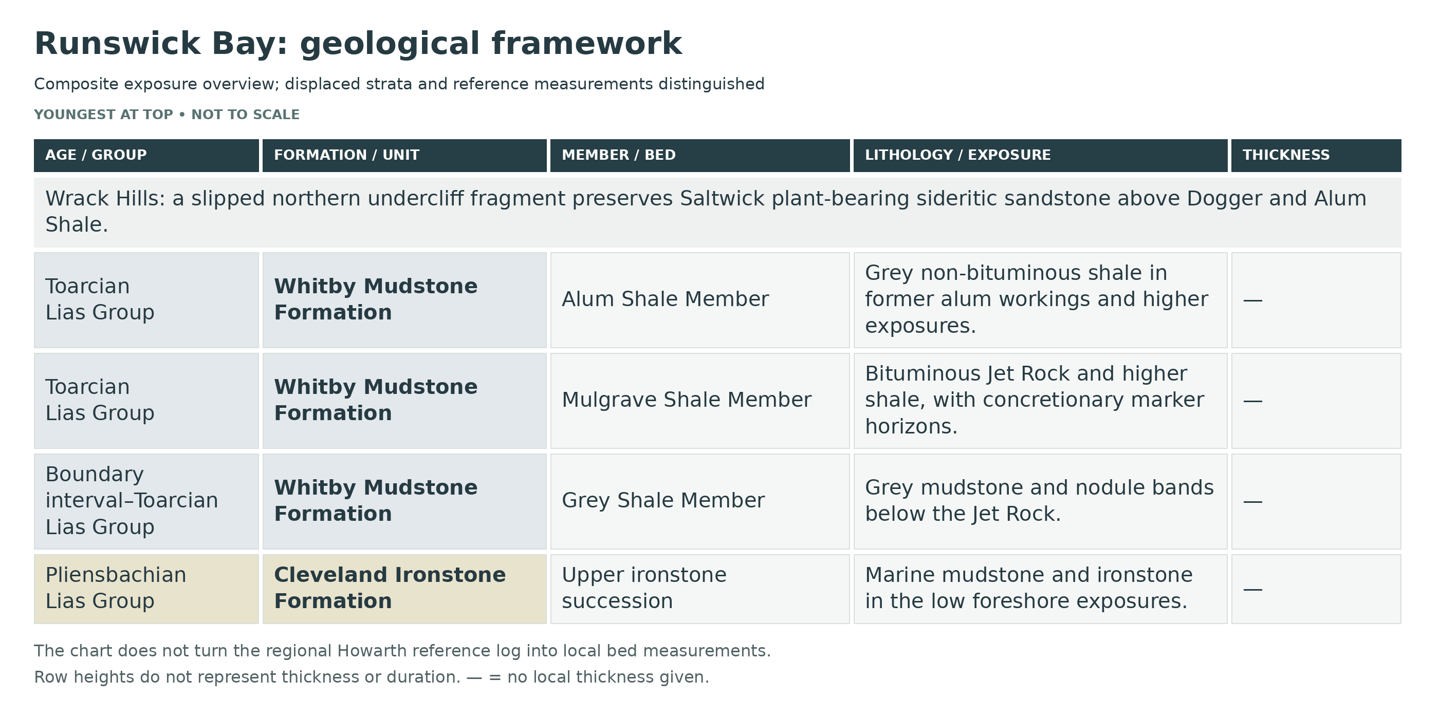
This is a detailed stratigraphic breakdown of Runswick Bay, where the rocky scars and foreshore expose upper Pliensbachian Cleveland Ironstone and lower Toarcian Whitby Mudstone, while the faulted and landslipped northern undercliff preserves a thin Dogger and the famous Saltwick Wrack Hills plant bed. The locality is important both for classic ammonite-controlled Yorkshire Lower Jurassic stratigraphy and for Britain’s most important Middle Jurassic site with three-dimensionally preserved plant fossils.
The main Wrack Hills plant exposure lies north of Runswick village, at the GCR locality centred on NZ 809 170. It is a landslipped Dogger–Saltwick fragment, not an upright section on the southern side of the bay. The numbered Lower Jurassic beds below follow published Yorkshire correlation schemes; the Grey Shale measurements below are the explicitly multi-locality Howarth 1973 composite, with individual fossil provenance distinguished. The chart assigns no numerical local thickness to them.
Runswick Bay is not a single clean cliff log. The centre of the bay is largely masked by landslip and glacial drift, bedrock is best seen on the rocky scars and foreshore around the village, Hob Holes and the north side of the bay, and the Wrack Hills plant bed occurs in a slipped undercliff slice rather than as an upright continuous cliff section.
Formal published Howarth bed numbers are retained below for the Cleveland Ironstone and Whitby Mudstone. Above the Lower Jurassic, the Dogger and Saltwick beds are described by named horizons and practical site-use intervals only, because at Runswick they are thin, faulted or slipped and do not form a single formal local bed-by-bed section.
LIAS GROUP
Cleveland Ironstone Formation (Upper Pliensbachian)
Kettleness Member
Uppermost Ironstone — Local Bed 24
The upper ironstone is present in the local foreshore succession. Howarth’s 1973 map and account identify it by the Kettleness-section number 24; the BGS framework places the top of the Cleveland Ironstone at that bed. This local numbering is not the Staithes 41–57 sequence previously reproduced here.
Regionally the Cleveland Ironstone includes marine mudstone, siltstone and berthierine–siderite ironstone, with the Pecten and Main seams in the Kettleness Member. Those regional seam descriptions explain the rock types, but a complete set of Staithes seam thicknesses and rare ammonite records is not assigned to this locality without a corresponding local log. The original detailed claims are retained in the revision archive rather than republished as verified local measurements.
Whitby Mudstone Formation (Pliensbachian–Toarcian Boundary Interval And Toarcian)
Grey Shale Member
Measured Grey Shale Composite And Exact Local Provenance
Howarth’s 1973 measured composite explicitly includes Runswick and west/east Kettleness for Beds 1–18, and east Kettleness for Beds 18–32. He describes little lithological variation, but shale thickness may vary by up to 25%. The following are his published composite measurements, not a claim that each bed was independently measured at every named reef. His total for Beds 1–32 is 13.56 m. Specimen-locality codes are respected where fossils are named below.
Howarth maps the main Grey Shale reef in the south-eastern bay, from its basal boundary near NZ 820155 westwards to Bed 33 at NZ 815156. The Red Nodule horizons and parts of Beds 19–20 were particularly clear. A separate small exposure of Beds 31–32 occurs at northern Topman Steel. These are historical exposure descriptions, not promises of present conditions.
Boundary Beds 25–28 — Older Kettleness Numbering
The BGS formal Cleveland Ironstone top is at local Bed 24. Howarth’s older Ironstone Series continued above it through Bed 25, 0.33 m sandy grey shale with basal nodules and Pleuroceras hawskerense; Bed 26, the 0.15 m laminated bituminous Sulphur Band; Bed 27, 0.46 m sandy shale; and Bed 28, a 0.05 m row of calcareous nodules with bivalves. The 1973 Grey Shale numbering restarts at 1 above Bed 28. These historical boundaries are not equated with the modern formation boundary.
Howarth 1973 Bed 1 — 0.51 m
Grey shale.
Howarth 1973 Bed 2 — 0.53 m
Dark-grey laminated bituminous shale; a parting may occur 0.20 m below the top. A basal nodule yielded Lytoceras at east Kettleness.
Howarth 1973 Bed 3 — 0.08 m
Continuous calcareous/sideritic mudstone, red-weathering; Protogrammoceras paltum is recorded from Runswick and east Kettleness, with indeterminate Dactylioceras at east Kettleness.
Howarth 1973 Bed 4 — 0.36 m
Grey shale.
Howarth 1973 Bed 5 — 0.05 m
Small rounded calcareous nodules; no ammonites recorded in the source collection.
Howarth 1973 Bed 6 — 0.53 m
Grey shale.
Howarth 1973 Bed 7 — First Red Nodules — 0.08 m
Calcareous and sideritic nodules, red-weathering; some contain belemnites and rarer bivalves.
Howarth 1973 Bed 8 — 0.41 m
Grey shale.
Howarth 1973 Bed 9 — Second Red Nodules — 0.05 m
A separate red-weathering concretion row of the same reported type.
Howarth 1973 Bed 10 — 0.25 m
Grey shale.
Howarth 1973 Bed 11 — Third Red Nodules — 0.05 m
A separate red-weathering concretion row.
Howarth 1973 Bed 12 — 0.30 m
Grey shale.
Howarth 1973 Bed 13 — Fourth Red Nodules — 0.05 m
A separate red-weathering concretion row.
Howarth 1973 Bed 14 — 0.23 m
Grey shale.
Howarth 1973 Bed 15 — Fifth Red Nodules — 0.08 m
A separate red-weathering concretion row.
Howarth 1973 Bed 16 — 0.20 m
Grey shale.
Howarth 1973 Bed 17 — Sixth Red Nodules — 0.08 m
Frequent calcareous/sideritic nodules with red exteriors; belemnites and occasional bivalves, without recorded ammonites.
Howarth 1973 Bed 18 — 0.38 m
Grey silty shale; a central row contains small nodules and calcified Dactylioceras crosbeyi clusters. Records include Runswick and both Kettleness exposures.
Howarth 1973 Bed 19a — 0.41 m
Grey shale; the basal 0.10 m is closely laminated and bituminous, with pale sandy masses about 0.30 m above its base.
Howarth 1973 Bed 19b — 0.05 m
Grey shale with red-weathering flat lenticular concretions and calcified D. clevelandicum clusters; recorded at Runswick and both Kettleness exposures.
Howarth 1973 Bed 19c — 0.81 m
Grey shale above the Clevelandicum horizon.
Howarth 1973 Bed 20 — 0.15 m
Two close rows of red-weathering calcified lenses; D. tenuicostatum is documented in the east-Kettleness collection.
Howarth 1973 Bed 21 — 0.76 m
Grey shale with occasional calcareous nodules; the species is documented from Runswick.
Howarth 1973 Bed 22 — 0.08 m
Small spherical nodules, commonly enclosing D. tenuicostatum; records include Runswick and east Kettleness.
Howarth 1973 Bed 23 — 0.38 m
Grey shale with occasional rounded calcareous nodules.
Howarth 1973 Bed 24 — 0.08 m
Another spherical nodule row with D. tenuicostatum; records include Runswick and east Kettleness.
Howarth 1973 Bed 25 — 0.61 m
Grey shale with occasional rounded nodules.
Howarth 1973 Bed 26 — 0.05 m
Thin flat red-weathering calcareous nodules; D. tenuicostatum is documented at east Kettleness.
Howarth 1973 Bed 27 — 0.61 m
Grey shale; rare flattened D. tenuicostatum in the composite account.
Howarth 1973 Bed 28 — 0.23 m
Two adjacent rows of large hard calcareous doggers, with less pyrite than Bed 30. D. semicelatum is documented at east Kettleness; the cited Cenoceras record is from Port Mulgrave, not assigned to these localities.
Howarth 1973 Bed 29 — 1.07 m
Grey shale with granular pyrite, especially below, and occasional flattened ammonites in the composite account.
Howarth 1973 Bed 30 — 0.10 m
Very hard calcareous doggers with abundant pyrite and D. semicelatum; east-Kettleness records are explicit.
Howarth 1973 Bed 31 — 2.13 m
Grey shale with crushed D. semicelatum, particularly near its middle; east-Kettleness specimens are recorded.
Howarth 1973 Bed 32 — 1.83 m
Grey shale, locally bituminous, with occasional flat upper nodules and shell beds at its base and 0.10 m above. Tiltoniceras antiquum is recorded at east Kettleness; the full faunal list in the paper combines several localities.
Mulgrave Shale Member
Howarth documents the whole Jet Rock at Topman Steel and only the lower interval through the Whalestones on the Hob Holes foreshore. The numerical bed values and broad faunas in the following marker descriptions are the published Yorkshire correlation framework; they are not separately measured Runswick values or a verified local specimen list for each bed.
Mulgrave Shale Member / Jet Rock Section Character At Hob Holes
In the middle of Runswick Bay, around Hob Holes, the Mulgrave Shale Member is classically exposed from just below the top of Bed 32 up to the Whalestones, with higher beds rising behind in the cliff and old jet workings. The lower part is the famous Jet Rock, a dark bituminous, pyritic mudstone succession with giant concretions, abundant ammonites and belemnites, and the jet horizons for which the Yorkshire coast became famous.
Topman Steel And Hob Holes — Distinct Exposures
Howarth records the whole Jet Rock at Topman Steel north of Runswick, whereas Hob Holes shows the upper part of Bed 32 through the Whalestones, with higher beds in the cliff and workings. The successive marker descriptions below are a composite reference account, not a claim that every horizon is visible in the Hob Holes foreshore. Runswick alum-quarry records remain separate again.
Bed 33 — Cannon Ball Doggers (0.15 m) — Published Yorkshire Reference Description
A narrow but very distinctive row of spherical concretions, commonly up to about 0.18 m across, at the base of the Mulgrave Shale Member. Elegantuliceras elegantulum is characteristic in the published reference fauna, including both macroconchs and microconchs. This bed marks the abrupt change from the grey nodular shales below into the darker, more bituminous Jet Rock facies above.
Bed 34 — Elegantulum Shales (2.7 m) — Published Yorkshire Reference Description
Grey bituminous shale with frequent calcareous concretions and common Elegantuliceras elegantulum. The shale is darker, more pyritic and more organic-rich than the Grey Shale Member below, showing the shift into lower oxygen bottom-water conditions that characterizes the Jet Rock. Fossils are commonly preserved within concretions rather than in the soft shale matrix.
Bed 35 — Whalestones (0.9 m) — Published Yorkshire Reference Description
Large ovoid concretions, some up to several metres long, together with many smaller calcareous concretions in grey bituminous shale. Cleviceras exaratum is common, with less frequent Harpoceras serpentinum and Phylloceras heterophyllum. The enormous concretions make this one of the most striking beds in the Runswick Bay section and show very early cement growth within highly organic muddy sediment.
Bed 36 — Exaratum Shales (1.08 m) — Published Yorkshire Reference Description
A grey bituminous shale above the Whalestones in which Cleviceras exaratum is characteristic. The bed continues the low-oxygen offshore mudstone facies of the Jet Rock and forms part of the ammonite-rich exaratum interval that makes the lower Mulgrave so important for lower Toarcian correlation.
Bed 37 — Curling Stones (0.3 m) — Published Yorkshire Reference Description
A row of spheroidal calcareous concretions with pyritic skins, usually up to about 0.45 m across. The published Yorkshire correlation fauna includes Cleviceras elegans, Harpoceras serpentinum, Dactylioceras semiannulatum, D. crassoides and Phylloceras heterophyllum. This is another classic jet-rock dogger line and a very useful field marker on the scar.
Bed 38 — Upper Pseudovertebrae Shale (1.54 m) — Published Yorkshire Reference Description
Grey bituminous shale with occasional concretions and the Upper Pseudovertebrae horizon about 0.3 m above the base. Cleviceras elegans, Harpoceras serpentinum and occasional Phylloceras heterophyllum occur. Like the other named jet-rock horizons, the bed represents dark organic-rich offshore sedimentation under restricted bottom-water oxygenation, with early diagenetic concretion development around fossil concentrations.
Bed 39 — Top Jet Dogger (0.23 m) — Published Yorkshire Reference Description
A continuous argillaceous limestone bed marking the top of the main Jet Rock concretionary interval. Cleviceras elegans and dactylioceratids are recorded. This hard, laterally persistent band is one of the clearest upper Jet Rock field datums and forms a natural marker for the transition toward the higher bituminous shales.
Bed 40 — Millstones (0.3 m) — Published Yorkshire Reference Description
Giant lenticular calcareous concretions, sometimes several metres across, set in grey bituminous shale. The published Yorkshire correlation fauna includes Cleviceras elegans, Hildaites murleyi and dactylioceratids. The sheer size of the concretions is remarkable and reflects intense localized early cementation within organic-rich muds on the Toarcian shelf.
Beds 41–47 — Bituminous Shales
Above the Millstones the Mulgrave passes into a thicker interval of bituminous shales with fewer large calcareous concretions, but with widespread pyrite, local sideritic bands, fossil wood including large logs, and abundant crushed or pyritized ammonites. Bed 41, the lowest part of this interval, is exposed on the foreshore below the village, while higher beds rise into the cliff behind the old jet workings. Harpoceras falciferum, dactylioceratids, Phylloceras heterophyllum and related forms are characteristic. Hard jet occurs in the upper part of the Jet Rock, and softer jet continues into the higher bituminous shales, showing prolonged organic-rich accumulation under dysoxic to anoxic bottom conditions.
Bed 48 — Ovatum Band (c. 0.25 m) — Published Yorkshire Reference Description
A double row of large doggers, commonly sideritic and weathering dark red, with pyrite masses and local concentrations of belemnites. Ovaticeras ovatum, dactylioceratids and Phylloceras heterophyllum have been recorded. This is the classic topmost marker of the Mulgrave Shale Member and forms the boundary horizon below the non-bituminous Alum Shale Member.
Alum Shale Member
Alum Shale Section Character At Runswick Bay
The Alum Shale Member is less continuously exposed in the main bay than the Grey Shale and Jet Rock, but lower parts were historically worked in the Runswick alum quarry north of the village and can be followed eastward around the bay toward Kettleness. The member consists of grey non-bituminous mudstones with abundant nodule lines and sideritic horizons, and it is sharply truncated upward by the Aalenian Dogger unconformity.
Beds 49–50 — Hard Shales (No Independent Local Thickness Assigned)
The base of the Alum Shale Member comprises harder, darker grey non-bituminous shales with sporadic calcareous doggers, pyrite masses and a continuous sideritic mudstone band weathering red. In the published Yorkshire reference account for Beds 49–50, crushed Dactylioceras commune and nodular D. temperatum are recorded. This is regional correlation context, not a separately verified Runswick collection of D. temperatum; the documented Runswick quarry ammonites are described separately below. These beds record the end of the strongly bituminous Jet Rock regime and the return to better oxygenated, though still quiet, offshore mud deposition.
Beds 51–54 — Lower Main Alum Shales (No Independent Local Thickness Assigned)
Grey shales with scattered doggers, large sideritic lenses weathering red, pyrite masses and fossiliferous nodule bands. The wider Yorkshire Main Alum Shale fauna includes Dactylioceras and hildoceratids, but that regional list is not a bed-specific Runswick record. In the Runswick alum quarry, nodules 22–24 feet above the Ovatum Band yielded many D. commune, and a fallen nodule from about the middle of Bed 51 produced Hildoceras sublevisoni. These beds are the key lower Alum Shale ammonite interval at Runswick.
Higher Alum Shale And Cement Shales
Above Bed 54 the Whitby Mudstone Formation continues upward through softer Main Alum Shales into upper Cement Shales with cementstone nodules, but this higher part is not shown as a clean continuous Runswick Bay cliff section. Regionally the Alum Shale Member is around 27 m thick at Whitby and up to about 37 m at Blea Wyke, but farther north-west many higher Toarcian zones are removed beneath the Dogger unconformity. At Runswick the important point is that the Aalenian transgression cuts down sharply onto this member.
Dogger Formation (Aalenian)
Bed S1 — Dogger Erosion Surface And Ferruginous Sandstone
At Runswick Bay the Dogger is not exposed as a long, simple tabular bed but as thin, faulted or slipped remnants around the northern undercliff and Caldron Cliff. Lithologically it is the usual Yorkshire coastal ferruginous sandstone to ironstone facies, grey-weathering to yellow-brown, locally with phosphatic pebbles and burrows descending into the underlying Alum Shale. Regionally the Dogger on the Yorkshire coast is generally only about 0.75–2 m thick. It records a marked Aalenian marine transgression and a pronounced disconformity above the Lower Jurassic mudstones, with substantial omission of upper Toarcian strata.
RAVENSCAR GROUP
Saltwick Formation (Aalenian)
Saltwick Section Character At Wrack Hills
The Saltwick Formation at Runswick Bay is represented not by a straightforward foreshore section but by a slipped undercliff slice at Wrack Hills. Excavation and mapping showed that the fossil-bearing undercliff had moved downslope from the main cliff some distance behind, so the plant bed must be treated as a landslipped but still geologically meaningful fragment of the lower Ravenscar Group.
Bed S2 — Basal Saltwick Claystone And Sideritic Sandstone
The exact Wrack Hills account records plant compressions in basal claystones and exceptionally preserved three-dimensional organs in sideritic sandstone. Its graphic log includes a carbonaceous horizon and the plant-bearing sideritic sandstone, with locally convoluted bedding and rooted sandstone higher up. Generic regional channels, crevasse splays and floodplain facies are not substituted for these observed local lithologies.
Bed S3 — Wrack Hills Plant Bed
The Wrack Hills plant bed is a siderite-rich ironstone horizon within the Saltwick Formation and is the most important Middle Jurassic plant locality in Britain. The flora is exceptionally well preserved in three dimensions as a result of very early diagenetic lithification, and more than 30 species have been recorded. Characteristic plants include Williamsonia gigas, cones of Androstrobus, and the male cone of Elatides thomasii; freshwater mussels traditionally referred to Unio occur with the flora and confirm the non-marine character of the deposit. The bed represents quiet-water accumulation in a floodplain pool, abandoned channel or very low-energy channel-margin setting where plant debris was rapidly entombed and sideritized before collapse and decay.
Bed S4 — Overlying Channel Sandstones And Rooted Floodplain Beds
The published Wrack Hills graphic log shows sandstone with vertical roots above the plant-bearing, locally convoluted sideritic sandstone. That rooted sandstone is the supported upper part of this particular section. Channelised sandstone, rooted mudstone and coaly horizons are common within the Saltwick Formation regionally, but they are not all independently demonstrated as successive beds above the Wrack Hills plant horizon. The slipped exposure must therefore retain its documented architecture without being expanded into a hypothetical full regional sequence.
Depositional Environment
Runswick Bay records a major environmental change from late Pliensbachian shallow-marine ironstone cycles in the Cleveland Ironstone Formation, into lower Toarcian offshore mud sedimentation of the Whitby Mudstone. The Grey Shale Member represents relatively open muddy shelf conditions with abundant ammonites and repeated concretion growth; the Mulgrave Shale Member records dark bituminous, pyritic, commonly dysoxic to anoxic offshore conditions that produced the Jet Rock and its jet horizons; the Alum Shale Member shows recovery to more oxygenated grey shelf mudstones before the Aalenian Dogger transgression cut down across the upper Toarcian. Above the unconformity, the Saltwick Formation records fluvial, floodplain and abandoned-channel environments with lush vegetation, freshwater mussels and localized sideritic plant preservation.
Total Thickness And Nature Of The Section
Runswick Bay is a composite locality rather than a single measurable vertical section. The main shore section shows the uppermost exposed Cleveland Ironstone and a substantial lower Toarcian Whitby Mudstone succession from the Sulphur Band through the Grey Shale and much of the Jet Rock, with lower Alum Shale worked and exposed north of the village; above that, a thin Dogger and a slipped slice of lower Saltwick occur on the northern undercliff. The locality is therefore unusually valuable because it combines classic ammonite-controlled Lower Jurassic marine beds with a famous Aalenian plant horizon in one small bay.
Wrack Hills Bed-Level Architecture
The published GCR figure shows Alum Shale beneath an unexposed interval and the Dogger, followed by the lower Saltwick plant-bearing package. The Dogger contains sandstone, bedded siderite and thinner shale layers. Above it, the Saltwick includes a carbonaceous horizon, plant-bearing sideritic sandstone with fossil wood or soft jet, locally convoluted bedding, and sandstone penetrated by vertical roots higher in the drawn section. Basal claystones preserve plant compressions, while the sideritic sandstone preserves three-dimensional organs through early carbonate cementation. These are observed components of the published slipped section, not an inferred complete fluvial log above and below the plant bed.
References
Howarth, M.K. (1955, 1962, 1973, 1992) on the Cleveland Ironstone, Grey Shale, Jet Rock and Alum Shale ammonite stratigraphy of the Yorkshire coast.
British Geological Survey Lexicon entries: Cleveland Ironstone Formation, Staithes Sandstone Formation, Whitby Mudstone Formation, Grey Shale Member, Mulgrave Shale Member, Alum Shale Member, Dogger Formation and Saltwick Formation.
Geological Conservation Review and Geologists’ Association material on Staithes to Port Mulgrave and the Runswick Bay / Wrack Hills Middle Jurassic plant site.
Rawson, P.F. & Wright, J.K. on the Yorkshire Jurassic coast and biostratigraphic correlation.
Van Konijnenburg-van Cittert, J.H.A. & Morgans, H.S. on the Wrack Hills plant bed and its three-dimensionally preserved Saltwick flora.
Yorkshire coast field guides and memoirs dealing with the Lower Jurassic of Runswick Bay, Kettleness and the Whitby district.

SAFETY
Common sense when collecting at all locations should be used and knowledge of tide times is essential. This part of the coastline is very dangerous as a result of tidal conditions, so make sure you return before the tide turns. Keep away from the base of the cliffs, as rock falls are very common. Hard hats are recommended.
EQUIPMENT
At Runswick Bay, careful observation is key, as the most productive finds usually come from hard, ovate or spherical nodules scattered across the foreshore, particularly after winter storms have scoured the beach. A geological hammer (16–24 oz) can be useful for carefully opening suitable loose nodules, and a flat chisel can help guide controlled blows along natural seams, while eye protection should always be worn to guard against flying fragments. Sturdy, waterproof footwear with good grip is important due to uneven rock surfaces and slippery algae, and it is vital to keep a close watch on the tide to avoid being cut off, especially when heading towards Kettleness. Any fossils collected should be carefully wrapped in paper or protective material and placed in a rigid container to prevent damage during transport.
CLEANING AND TREATING
Begin by removing any loose sediment very carefully using a soft toothbrush. Take your time, as many fossils—particularly pyritic specimens—are fragile and easily damaged. Fragile shale fossils and pyritic specimens should remain supported in their matrix and need individual assessment before wet cleaning. Do not apply a fixed soaking time to every specimen. After any appropriate wet cleaning, allow specimens to dry naturally at room temperature. Do not dry them on radiators or other heat sources, as rapid drying can cause cracking or long-term damage.
Where consolidation is needed, Paraloid B-72 is a well-established conservation resin. It can often be re-dissolved, but removal from a porous fossil may be incomplete. Use it selectively after assessing the specimen and matrix; it is not a moisture-proof seal or a cure for pyrite decay.
Avoid cosmetic varnishing before identification and assessment, as coatings can obscure detail and complicate later preparation. Keep pyritic specimens in dry, monitored storage and check for cracking or powdery deposits; seek conservation advice if deterioration appears.
IDENTIFY YOUR FINDS
Need help identifying a fossil? Share clear photos, where you found it and its size with the community.
FURTHER READING
Deposits – Whitby Jet and the Toarcian Oceanic Anoxic Event (regional geology)
Geological Conservation Review – The Jurassic palaeobotany of Yorkshire
British Geological Survey – Saltwick Formation
British Geological Survey – Cleveland Ironstone Formation
ACCESS RIGHTS
This site is a site of special scientific interest (SSSI). This means you can visit the site, but hammering the bedrock is not permitted. For full information about the reasons for the status of the site and restrictions, download the PDF from Natural England
It is important to follow our ‘Code of Conduct’ when collecting fossils or visiting any site. Please also read our ‘Terms and Conditions‘
LINKS
♦ Fossil Discussions
♦ Fossil Articles
♦ Buy Fossils, Tools and Equipment
♦ Buy Crystals, Meteorites, and Artefacts
♦ Join Fossil Hunts
♦ UK Fossils Network