

Overview
Directions
- Approach Sandsend on the A174, north of Whitby. The council Sandsend car park is at Lythe Bank, YO21 3TG, with ticketless payment and seasonal charges shown on current signs.
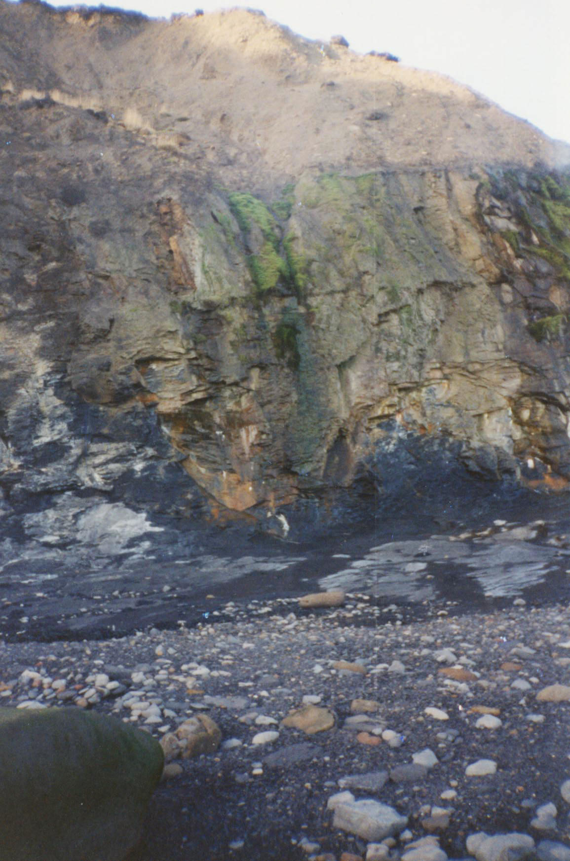
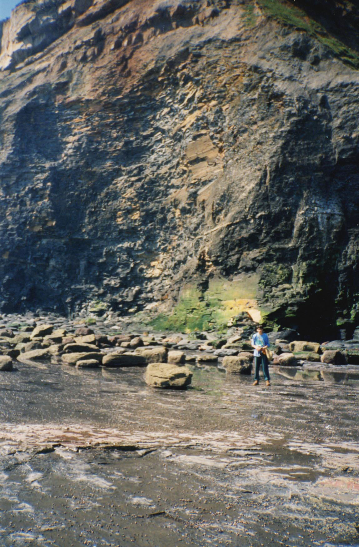
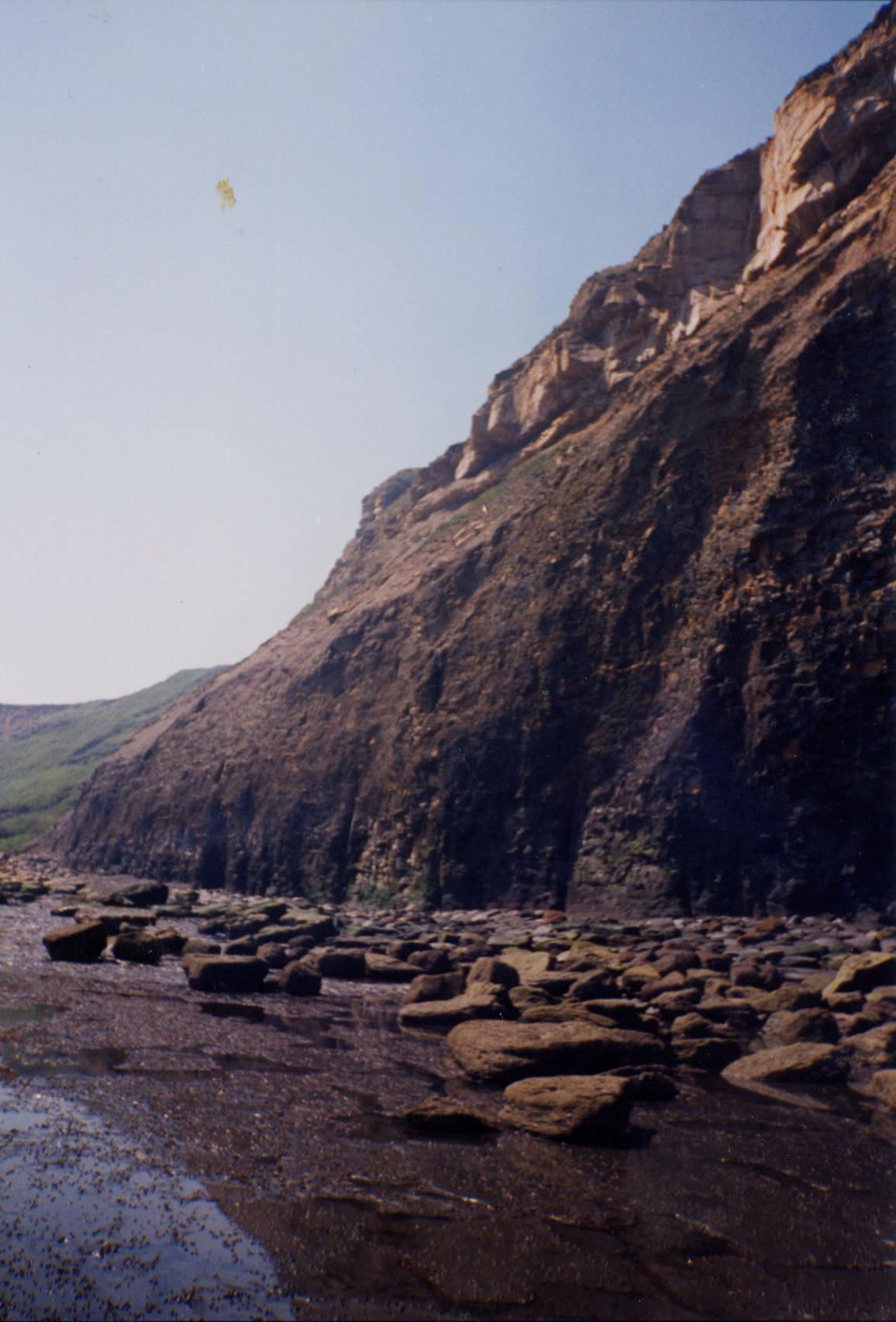
- From the north end of the village, the fossil shore involves a long walk over rough, slippery foreshore. Plan around the tide and swell, with enough time to return before the route is threatened.
- Car-park opening hours do not mean the northern shore is usable at high tide. Do not enter old adits or tunnels or use industrial remains as routes.
- Approximate locality reference: 54.50464°N, 0.67283°W. This is not a verified parking or shore-access pin.
Location photographs
Swipe to browse · Select a photograph to enlarge

Fossil Hunting
The fossil-bearing shore lies north of the village, where dark shale and hard concretions offer two very different kinds of ammonite preservation. A shale flake may carry only a flattened coil or an impression, while a limestone nodule can preserve a shell in three dimensions. Pyrite may replace the fossil or form a metallic-looking skin. Start with the surfaces of naturally loose, safely accessible material: a curved shell edge, repeated ribs or part of a coil is more useful evidence than the round shape of a nodule alone. Sand cover, algae and a shortage of suitable loose stone can make a visit unproductive even where the underlying rocks are fossiliferous.
Ammonites. Eleganticeras elegantulum is securely recorded from the lower Jet Rock at Stonecliff End in Deepgrove Wyke, including specimens in Howarth’s collections from beds 33 and 34. It is a useful comparison for relatively smooth-looking ammonites: larger shells can lose much of their ribbing, whereas the small adult form has blunter ribs on the final whorl. A defined edge around the central hollow and the shape of the whorl matter as well as ornament. A small fossil is therefore not necessarily a juvenile. The local record includes variation towards more strongly ribbed forms, so do not identify every smooth or faintly ribbed coil from one feature.
The Cannon Ball Doggers of Bed 33 are a particularly important matrix for Eleganticeras. These are rounded limestone concretions with pyritic outer skins; weathered pieces may reveal the plane of an ammonite through the interior. Howarth’s historical collections demonstrate the fauna, but do not measure how many collectable nodules are now on the beach. The named bands are reference horizons to recognise and record, not rock to dismantle. If a permitted loose piece shows a fossil, keep the whole piece and any counterpart rather than chasing the shell with a hammer.
Harpoceras falciferum is another documented Sandsend ammonite, illustrated in specimen accounts from the locality. Look for the characteristic sickle-shaped ribs sweeping forward towards a sharp keel on the outer edge; the coiling leaves only part of the earlier whorls exposed. Its Jurassic horizon belongs to the younger Bituminous Shales succession, above the lower Jet Rock that yields Eleganticeras. The local shore includes beds 41, 42 and the lower part of 43, although a loose specimen cannot be assigned to one of them merely because it was found nearby. Worn, flattened or incomplete shells may need comparison with several views of an identified specimen before a species name is reliable.
Other finds. Shell fragments and altered fossil wood broaden the search beyond ammonites. Jet is fossil wood transformed during burial, not a separate formation or evidence of a forest growing on this spot. Preserve any visible wood structure rather than polishing a promising piece immediately. Marine-reptile material is a much less realistic target than ammonites and shells: a historical museum catalogue documents a Sandsend marine crocodile, but that is not evidence of frequent modern finds. Photograph possible bone where it lies, retain matrix and associated pieces, and seek museum advice before preparation.
Record the precise beach position and whether the find was in a loose nodule, shale or other debris. Quarrying, jet extraction and wave action have all redistributed rock here, so useful provenance includes how it was found as well as where. Search only where collection is permitted, stay clear of cliff feet and recent falls, and leave archaeological material and alum-working remains untouched.
Discoveries and milestones
A chronological record of discoveries, research and conservation at Sandsend.
1733 – Alum quarrying at Gaytrees
Gaytrees was the earliest of the three Sandsend coastal alum quarries, working from 1733. Quarrying progressed northwards to Ness End and Deep Grove, profoundly changing the exposure.
1811–1933 – Cement stone extracted at Deep Grove
Cement-stone mining overlapped the alum industry and continued afterwards. The material was processed at a mill south of the village; industrial spoil and workings therefore form part of the locality’s geological history.
1849 – The alum house mapped
The Sandsend alum house is documented on a mid-nineteenth-century map. Surviving and buried remains lie north of Sandsend Beck, partly beneath the later car park.
1962 – The Jet Rock outcrop mapped in detail
Howarth distinguished the named concretion horizons around Deepgrove Wyke, Sandsend Ness and the Scar, providing an exact-locality framework for the shore exposures.
1984 – Museum reptile provenance catalogued
Benton and Taylor’s systematic review lists a Sandsend marine crocodile specimen in the Yorkshire Museum under the historical label Teleosaurus chapmani. That dated catalogue record supports a local occurrence but does not establish the specimen’s current taxonomy or discovery year.
1994 – Millstones and jet workings described
The local naturalists’ annual report describes the Sandsend Ness Millstones and the practical history of jet extraction. The old workings remain archaeological features and dangerous voids, not collecting routes.
29 April 1998 – Industrial remains scheduled
The alum quarries and works, and the Sandsend alum house, were separately scheduled as monuments. Their protected archaeological remains must be respected alongside the geological exposures.
2018 – Ammonite preservation investigated
Swaby’s undergraduate study included Deepgrove and Overdale Wyke sampling sites near Sandsend, examining how deposition and later alteration affected ammonite preservation. Its multi-locality conclusions must not all be assigned to a single Sandsend bed.
Geology
The dark rocks north of Sandsend record an Early Jurassic sea. They belong to the Toarcian Whitby Mudstone Formation of the Lias Group, and their thin shale layers were originally fine sediment settling on the sea floor. In the organic-rich Mulgrave Shale Member, restricted oxygen at the bottom helped preserve organic matter and fine lamination. Burial compressed many ammonites with the mud, while hard calcareous concretions protected others from flattening. This is why a thin shale impression and a substantial nodule can contain fossils of quite different appearance from the same part of the succession.
Within the Mulgrave Shale, the lower Jet Rock carries altered fossil wood and conspicuous concretion bands. Deepgrove Wyke and Sandsend Ness expose local occurrences of the Cannon Ball Doggers, Whale Stones, Curling Stones, Top Jet Dogger and Millstones. Their resistance to erosion helps form the uneven foreshore scar while the surrounding shale wears away. The Bituminous Shales above continue the marine mudrock story, with beds 41, 42 and the lower part of 43 recorded on the shore south of the Ness. The individual local occurrences are described below; they are not a measured column borrowed from Port Mulgrave.
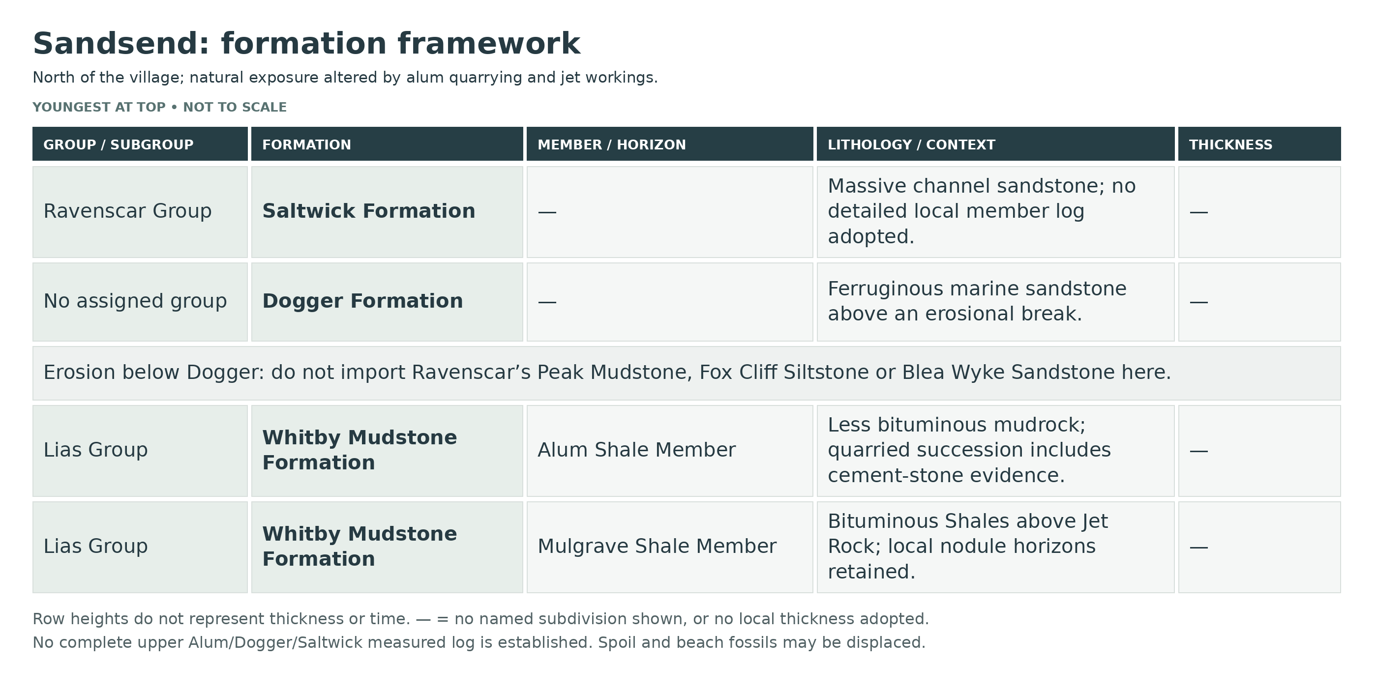
Higher in the Whitby Mudstone succession, the Alum Shale Member is less strongly bituminous and includes the cement-stone-bearing levels exploited locally. Above it, the Aalenian Dogger Formation rests on an erosional break and represents a later shallow-marine episode with iron-rich sandstone. The gap matters: Sandsend does not preserve the thick intervening upper-Toarcian Blea Wyke succession seen at Ravenscar. The younger Saltwick Formation, part of the Ravenscar Group, then records rivers and coastal-plain environments in its channel sandstones. The Top Jet Dogger is only a named concretion horizon in the older shale and must not be confused with this younger Dogger Formation.
The present landscape also has an industrial history. Alum quarrying reshaped the upper slopes, and jet and cement-stone extraction left workings and redistributed rock. A loose shale or nodule may consequently have travelled through spoil as well as down the natural cliff. Distinguishing undisturbed beds, beach debris and industrial remains is essential to understanding a find; it also explains why a named fossil does not by itself establish a precise collecting horizon. The upper Alum Shale–Dogger–Saltwick account below remains a bounded local framework, rather than claiming a complete measured log.
Detailed geology and bed-by-bed succession
Detailed geology and fossil-bearing horizons at Sandsend.
LIAS GROUP
The dark Jurassic marine mudrocks north of Sandsend belong to the Lias Group. Historical alum workings and jet extraction altered the cliffs and left industrial remains; loose material may have been moved by both quarrying and the sea.
Whitby Mudstone Formation
Toarcian marine mudrocks form the principal fossil-bearing succession. The lower organic-rich Mulgrave Shale and overlying Alum Shale members record changing bottom-water conditions; later quarrying and jet mining altered the natural exposure.
Mulgrave Shale Member
Organic-rich, laminated shale records oxygen-poor marine bottom conditions. Its jet-bearing lower interval and bituminous upper shales are important to the industrial and fossil history. Do not transfer the Ravenscar Peak Stones or its Roman bed numbering to Sandsend.
Jet Rock
The lower jet-bearing shale contains fossil wood transformed into jet. Beach-level shallow adits at Sandsend are independently recorded by BGS. These historic workings are hazards and archaeological features, not places to enter or dig. Regional thickness quoted for Jet Rock is not presented as a measured Sandsend value.
Deepgrove Wyke: beds 32–34
Howarth’s 1962 account records beds 32, 33 and the lower part of 34 at Stonecliff End. Boulder cover interrupts the outcrop; the basal boundary continues beneath it. These local numbers belong to his northwestern-coast scheme. At Stonecliff End a nodule horizon was recorded approximately 3 ft above the base of Bed 34.
Cannon Ball Doggers
The named concretion band and Bed 34 were recorded on the southern side of Deepgrove Wyke. Their presence here is independently documented rather than assumed from another beach. Howarth’s local correlation number is 33.
Whale Stones and Curling Stones
Whale Stones occur on the northern part of Sandsend Ness. Curling Stones were mapped just southwards and in a small patch on the seaward Scar. These are nodule horizons within the Jet Rock, not formations. Howarth’s local correlation numbers are 35 and 37.
Top Jet Dogger
This tough calcareous horizon occurs on the Scar and formed a roof marker for historical jet workings. Its traditional name denotes a concretionary bed within the Mulgrave Shale Member, distinct from the much younger Dogger Formation. Howarth’s local correlation number is 39.
Millstones
The main Scar comprises Top Jet Dogger with Millstones; Bituminous Shales overlie it to the south. The 1994 local naturalists’ report independently records large discoidal Millstones at Sandsend Ness, visible on very low tides. Howarth’s local correlation number is 40.
Bituminous Shales
These organic-rich shales overlie the Jet Rock and its top marker within the Mulgrave Shale Member. Fossils can be flattened in shale or better preserved in concretions; no neighbouring measured-bed sequence is claimed for the Sandsend foreshore.
Bed 41 — lower Bituminous Shales
Bed 41 shale begins south of the Ness Scar. Boulder cover interrupts it before it reappears farther south; no thickness from another coast section is assigned here.
Bed 42 — dogger band
The concretion band crosses the scar north of the former Sandsend station, above the re-emergent Bed 41. The historic station is a location reference, not a modern access instruction.
Lower Bed 43
The lower part of Bed 43 is exposed above Bed 42 before the scar disappears beneath sand southwards. The complete regional Bed 43 thickness is not an observed Sandsend thickness.
Alum Shale Member
Less strongly bituminous mudrocks above the Mulgrave Shale were exploited in the coastal alum quarries. The independent heritage record distinguishes the Gaytrees, Ness End and Deep Grove workings north of the village. Quarry floors and spoil complicate the relationship between a loose fossil and its original horizon.
Cement-stone-bearing upper alum succession
The Sandsend industry also exploited cement stone, mined at Deep Grove and processed south of the village. This supports retaining the cement-stone aspect of the upper mudrock succession, but not transplanting a Whitby Cement Shales thickness or its detailed numbered bed log.
Erosional break below the Dogger Formation
The original geological account describes a strong erosional base placing Dogger sandstone on the Alum Shale Member. Unlike Ravenscar, the upper Toarcian Peak Mudstone, Fox Cliff Siltstone and Blea Wyke Sandstone sequence should not be inserted here.
Dogger Formation
Aalenian marine ferruginous sandstone caps an erosional break above the Alum Shale. The formation has no assigned parent group in the modern framework. The thick Blea Wyke development and its named shell beds are not part of this Sandsend log.
RAVENSCAR GROUP
The younger coastal-plain succession above the marine Dogger begins locally with the Saltwick Formation.
Saltwick Formation
Massive channel sandstones are described in the Sandsend area by the original guide. They record rivers crossing a coastal plain after the marine mudrock phase. This member-free description is retained without inventing a detailed local sandstone log.
References
Existing UK Fossils Sandsend guide
BGS: Engineering geology of British rocks and soils, industrial applications
BGS: Lias Group introduction
Historic England: Alum quarries and works 800 m north of Sandsend Bridge
Howarth (1962), The Jet Rock Series and the Alum Shale Series of the Yorkshire coast
Whitby Naturalists’ Club Annual Report 1994: The origins of Whitby jet
BGS Lexicon: Dogger Formation
BGS Lexicon: Saltwick Formation
Safety
Tides can reach the cliff foot and remove the return route. The northern foreshore is very slippery with seaweed and algae, with limited shelter below unstable high cliffs. Check sea conditions, allow a generous return margin and turn back early if footing or weather deteriorates.
Stay away from recent falls and never dig or climb the cliffs. Do not enter jet or cement-stone adits, tunnels or other industrial structures. A fresh fall is a hazard, not a reason to approach an unstable face.
Equipment
Use grippy sturdy footwear and carry tide information, a phone, hand lens, camera or notebook, and padded rigid containers. Avoid picks or other tools that could damage fixed exposures or historic remains.
Cleaning And Treating
Support fragile shale fossils and allow them to dry slowly. Water can break down the matrix, so do not routinely wash or soak specimens. Keep part, counterpart and their labels together.
Concretion fossils may need skilled preparation. Avoid acid, routine coatings and repeated wetting; monitor pyrite deterioration. Retain matrix on possible reptile bones and seek specialist advice before cutting or aggressive preparation.
Identify Your Finds
Need help identifying a fossil? Share clear photos, where you found it and its size with the community.
Further Reading
Deposits: Bringing the best out of your fossils
Howarth (1962), The Jet Rock Series and the Alum Shale Series of the Yorkshire coast
Whitby Naturalists’ Club Annual Report 1994: The origins of Whitby jet
Benton & Taylor (1984), Marine reptiles from the Upper Lias of the Yorkshire coast
Swaby (2018), Taphonomy of ammonites from the Toarcian Whitby Mudstone Formation
BGS: Engineering geology of British rocks and soils, industrial applications
Historic England: Alum quarries and works 800 m north of Sandsend Bridge
Historic England: Sandsend alum house
North Yorkshire Council: Sandsend car park
Natural England: coastal access Sandsend Bridge–Staithes Beck
Access Rights
The northern alum quarries and works, and the alum house, are Scheduled Monuments. Do not damage standing remains, dig industrial spoil or remove archaeological material. Public access does not establish unrestricted collecting permission: follow current landowner and management requirements, conserve fixed exposures and observe local closures.
It is important to follow our ‘Code of Conduct’ when collecting fossils or visiting any site. Please also read our ‘Terms and Conditions’.
Links
♦ Fossil Discussions
♦ Fossil Articles
♦ Buy Fossils, Tools and Equipment
♦ Buy Crystals, Meteorites, and Artefacts
♦ Join Fossil Hunts
♦ UK Fossils Network


