

Sandy Mouth combines a sandy beach with folded late Carboniferous sandstone and shale. Fine-grained rocks can preserve plant fragments, while the named Sandy Mouth Shale has documented bivalves, ammonoids and fish remains. The tide-dependent rocky shore south of the entrance needs more care than the main bathing beach.


FIND FREQUENCY: ♦♦♦ – Plant fragments occur in suitable fine-grained rocks; documented marine fossils are localised and much less predictable.
CHILDREN: ♦♦♦ – The main beach has visitor facilities and seasonal lifeguard cover. Keep children away from cliffs and tidal rocky routes.
ACCESS: ♦♦♦ – National Trust parking, then a short descent with steps and uneven ground. The beach is not step-free.
TYPE: Sandstone, siltstone and shale of the Bude Formation, with plant debris and local fossiliferous marine-shale horizons.
DIRECTIONS
♦ From the A39 south of Kilkhampton, follow signs west towards Stibb and Sandymouth. Continue beyond Stibb and take the signed left-hand route to the beach car park.
♦ The National Trust visitor information gives EX23 9HW for satnav. Check current opening and payment arrangements before travel; the car park is advertised dawn to dusk, with no overnight parking or camping, and phone signal can be poor.
♦ Follow the established path and steps to the shore. Toilets, including an accessible toilet, and a café are advertised seasonally; the easier route to the facilities does not make the beach itself step-free.
♦ The original plant-search area starts about 200 m south of the entrance steps, towards Northcott Mouth. Only continue over the rocky foreshore in suitable tides and swell, and remain clear of cliff bases and fresh falls.
♦ Original locality reference: 50.86107°N, 4.55710°W. This is the locality point, not the car-park entrance.
FOSSIL HUNTING
The most realistic starting point is fine-grained mudstone or siltstone with already exposed bedding surfaces. The original guide records plant remains, especially stems, in loose material south of the entrance, beginning about 200 m towards Northcott Mouth. Dark carbonaceous films or faint impressions may show longitudinal marks, but many fragments are incomplete. They should not automatically be named as a fern, tree or particular plant genus.
The fine-grained beds are more informative than many of the massive sandstone blocks. Some shale and siltstone layers reach beach level, while others occur higher in the folded cliffs. Do not search below fresh falls to obtain them. Examine safely accessible, already loose surfaces within current collecting rules; shattering mudstone with a hammer can destroy the delicate film that carries the fossil.
Sandy Mouth has a securely documented marine fauna. BGS recorded Caneyella bivalves and the ammonoid Anthracoceratoides cornubiensis opposite the entrance steps. Samples from a repeated exposure of Sandy Mouth Shale include Dunbarella and fish remains. These are particular scientific records from dark shale and concretions, not an assurance that visitors will find complete shells or fish in ordinary beach stones.
The locality is especially significant because the holotype of Anthracoceratoides cornubiensis, HR2162, came from a foreshore nodule opposite the entrance steps. Six uncrushed paratypes were also described from the same collecting point. The genus and species were formally described in 1970. That history makes well-recorded specimens scientifically valuable, but it does not imply that the precise old exposure is visible today or confer permission to collect.
Bivalves may appear as partial impressions with radial ribs or concentric growth lines. A goniatite ammonoid has a coiled shell or its impression, but a round patch alone is not diagnostic; species identification needs appropriate ornament and, where visible, sutures. Fish remains are normally fragmentary scales or other parts rather than complete animals. Photograph an associated patch with a scale before disturbing it, and leave important in-place specimens for advice.
Quartz veins, mineral stains, cleavage and current markings can resemble plant stems or tracks. Ripple marks, load casts and flute or groove casts are sedimentary structures. A biological identification needs consistent detail, such as an organised shell margin, repeated scales or a coherent burrow pattern. Record the rock type and whether a specimen came from a known bed or mixed loose debris; proximity to a cliff band alone does not prove a nodule’s original horizon.


A chronological record of fossil discoveries, geological research and site history at Sandy Mouth.
1970 – New ammonoid genus and species described
W. H. C. Ramsbottom formally described Anthracoceratoides and its type species Anthracoceratoides cornubiensis. The holotype HR2162 and six uncrushed paratypes came from the foreshore opposite the Sandy Mouth entrance steps, giving the locality a precise place in the taxon’s scientific history.
1979 – Local measured sections and fossil records published
The Bude and Bradworthy geological memoir documented the Sandy Mouth Shale occurrences, their structural differences, local fossil samples and measured sandstone–shale sections around the entrance. This is a documentation milestone rather than a claim of first discovery.
29 September 1996 – Coastal exposures notified as an SSSI
Duckpool to Furzey Cove was notified as a Site of Special Scientific Interest, recognising nationally important exposures in the Bude Formation type area, including Sandy Mouth.
GEOLOGY
The cliffs belong to the Bude Formation of the Holsworthy Group. These are late Carboniferous rocks, not the Lower Carboniferous succession described in the old introduction. Sandstone dominates many exposures, but shale, siltstone and mudstone preserve quieter episodes of sedimentation and the most useful fossil records. “Bude Sandstones” is historical terminology for this broader succession.
Sand and silt deposition alternated with quieter mud accumulation. Some dark shale horizons contain marine fossils, providing evidence of marine incursions within a depositional system whose lake, shallow-water, storm and sediment-gravity-flow influences remain debated. The formation-wide Langsettian–Bolsovian range does not give every specimen an identical age; particular faunas and marker horizons provide the finer correlations.
Variscan deformation folded and faulted the beds after deposition, repeating Sandy Mouth Shale around the beach. One exposure is only 6–7 m thick, whereas another has approximately 17 m of apparent shale thickness because it has been structurally expanded. Elsewhere part of the shale is sheared out. These differences cannot be read simply as original sediment accumulation, nor can every cliff face be treated as one continuous stratigraphic column.
The larger shale exposure contains silty bands, a hard sandstone high in the interval and two levels of disc-like carbonate concretions lower down. North of the steps, a measured section ends at the top of the named shale and includes slumped sediment, laminated rock and a burrowed surface. Two separate sandstone–shale sections farther south add load casts, mud clasts and explicit faults. Their detailed records are retained below with distinct coordinates rather than combined into an artificial complete succession at the entrance.

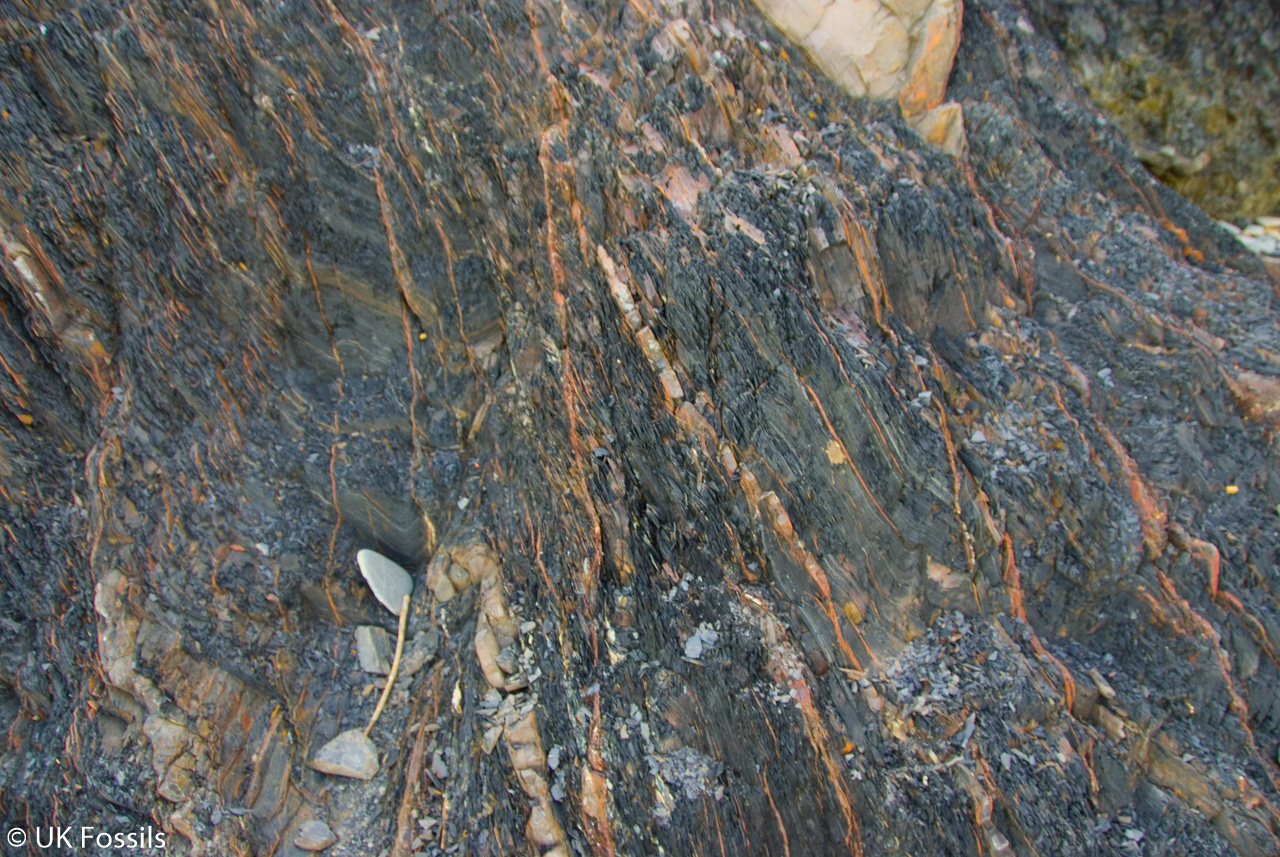
Detailed geology and stratigraphy of Sandy Mouth, including the limits of local correlation.
The detailed northern limit here is the NW–SE wrench fault at SS20121020. The measured section between that fault and SS20151009 leads down to the top of Sandy Mouth Shale, beside the main beach. More distant sections towards Warren Gutter, north of the fault, are regional context and are not imported. Two separate southern sections, ending towards Northcott Mouth, follow the local shale observations below. Every table is described from stratigraphic top to bottom; the coordinates identify scientific sections, not walking routes.
HOLSWORTHY GROUP
The sandstone-rich Bude Formation belongs to the Holsworthy Group. Neither the group nor the formation’s regional thickness is equivalent to cliff height at Sandy Mouth.
Bude Formation
Sandstone alternates with siltstone and mudstone, including named dark-shale horizons useful for correlation. The formation as a whole spans Langsettian–Bolsovian time; the local marine fauna provides finer correlation within its older part. Sandy Mouth Shale is a named horizon, not a formal member.
Sandy Mouth Shale at SS20151009
A 6–7 m shale exposure contains Caneyella and anthracoceratid ammonoids. This measurement belongs to this occurrence and must not be substituted for the thicker, structurally expanded shale farther south.
Structurally expanded shale at SS20171000
Approximately 17 m of apparent shale thickness is explicitly described as structurally expanded. Black shale contains silty bands, and a hard grey sandstone occurs 4.5 m below the top. The 17 m is not an undeformed depositional thickness.
Lower concretion levels in the expanded shale
Laminated, disc-like carbonate concretions are most strongly developed about 4 m above the base, with a less developed level about 5 m above it. The recorded fauna includes Caneyella, Dunbarella, Anthracoceratoides cornubiensis and fish remains. The measured heights apply to this expanded exposure; they are not thicknesses of the concretion bands.
Sheared shale at SS20180988
Part of the shale is removed by shearing. The missing interval is not reconstructed with guessed beds, and this occurrence should not be drawn as an intact type column.
Entrance-step samples and type material
At SS20111000 the memoir’s specimen records HR2156–69 and WT86–7 document Caneyella and Anthracoceratoides cornubiensis. Ramsbottom’s original taxonomic account gives the holotype HR2162 and six uncrushed paratypes from a nodule locality opposite the steps at SS20180992. These are the separately published locality references, not an exact modern collecting pin. The naming date is 1970, not a verified discovery date. The original marine-band correlation was an interpretation based partly on South Wales material.
Clay minerals and mineralised concretions
At SS20151009, the analysed shale contains illite with kaolinite. The memoir describes the calcareous nodules as predominantly ankeritic and records a thin dickite- and sphalerite-bearing vein in one Sandy Mouth nodule. These observations distinguish the carbonate body from a later mineral-filled fracture. They are not extra fossil beds, and an individual vein should not be treated as characteristic of every nodule.
Northern near-entry section: SS20121020–SS20151009
This measured section starts at the NW–SE wrench fault and descends through seventeen lithological intervals to the top of Sandy Mouth Shale. It lies immediately north of the beach entrance. Approximate source values remain approximate; the fault is a bounding structure, not an added sedimentary bed.
Section N, interval 1: about 20.0 m
Massive slumped bed.
Section N, interval 2: 1.5 m
Black shales.
Section N, interval 3: 4.0 m
Sandy slumped bed.
Section N, interval 4: 7.0 m
Shales.
Section N, interval 5: 5.6 m
Well-bedded pale-grey-weathering sandstones.
Section N, interval 6: 13.0 m
Massive sandstones with a 2-m banded sandstone 10 m above the base.
Section N, interval 7: 11.4 m
Medium-bedded sandstones.
Section N, interval 8: 1.5 m
Black shales with 20-mm sandstone bands.
Section N, interval 9: 9.1 m
Medium-bedded sandstones.
Section N, interval 10: 12.5 m
Black shales with many thin sandstones up to 0.2 m thick.
Section N, interval 11: 3.6 m
Thinly bedded sandstones with abundant mudstone.
Section N, interval 12: 1.0 m
Laminated sandstones.
Section N, interval 13: 1.5 m
Massive mudstone.
Section N, interval 14: 1.0 m
Laminated sandstones.
Section N, interval 15: 6.0 m
Medium- to thinly bedded sandstones.
Section N, interval 16: 2.6 m
Laminated siltstones and sandstones showing ripple-drift cross-lamination; burrowed at the top.
Section N, interval 17: 19.8 m
Medium-bedded sandstones; beds up to 2.5 m thick.
Section N, interval 18: Top of Sandy Mouth Shale
This named top boundary terminates the measured section. It is not a separate sediment thickness or permission to insert another shale log.
Southern section A: SS20170956–SS20170944
This first southern measured section includes a bedding-parallel fault, disturbed sediment and contrasting sandstone and fine-grained packages. Read the following entries down-section; do not add their thicknesses across the fault into a claimed uninterrupted depositional total.
Section A, interval 1: 8.0 m
Massive, rather brecciated sandstone.
Section A, interval 2: 1.7 m
Dark grey shales with thin ironstone bands.
Section A, interval 3: 3.5 m
Massive sandstone.
Section A, interval 4: 2.0 m
Laminated silty sandstones.
Section A, interval 5: Fault parallel to bedding
The source records this structural break at this position. No thickness is assigned, and the succession is not joined across it as if deposition were uninterrupted.
Section A, interval 6: 0.9 m
Laminated mudstones and siltstones, possibly a slumped bed.
Section A, interval 7: 0.9 m
Laminated siltstones.
Section A, interval 8: 4.0 m
Massive sandstones up to 1 m thick.
Section A, interval 9: 3.5 m
Medium-bedded sandstones.
Section A, interval 10: 1.6 m
Massive sandstone.
Section A, interval 11: 9.4 m
Disturbed sandstones and shales.
Section A, interval 12: 3.2 m
Thickly bedded and massive sandstones.
Section A, interval 13: 1.7 m
Black shales with laminated sandstones.
Section A, interval 14: 1.4 m
Sandstone.
Section A, interval 15: 4.3 m
Laminated siltstones, mudstones and some shales with thin sandstones.
Section A, interval 16: 1.7 m
Medium-bedded sandstones.
Section A, interval 17: 1.6 m
Silty sandstones and mudstones.
Section A, interval 18: 2.4 m
Massive sandstone.
Section A, interval 19: 2.6 m
Thinly bedded sandstones.
Section A, interval 20: 1.9 m
Poorly bedded sandstone with large load-casts.
Section A, interval 21: 1.0 m
Disturbed siltstones, with some laminated and cross-laminated layers.
Section A, interval 22: 8.0 m
Massive sandstones up to 0.4 m thick with laminated siltstones and mudstones.
Section A, interval 23: 7.8 m
Massive sandstones, one showing flute-casts.
Section A, interval 24: 8.4 m
Sandstones up to 0.3 m thick with interbedded mudstones.
Section A, interval 25: 1.8 m
Mudstones with sandy bands.
Section A, interval 26: 4.2 m
Laminated silty mudstones with some sandstone at the top.
Section A, interval 27: 1.2 m
Sandstone.
Section A, interval 28: 1.5 m
Mudstones with thin sandstones.
Section A, interval 29: 4.3 m
Sandstones with interbedded mudstones.
Adjacent southern section B: SS20180926–SS20150909
This section is farther south towards Northcott Mouth and terminates at the top of Saturday’s Pit Shale. It is an adjacent measured section, not a claim that every bed is visible beside the entrance. Its small fault and terminal boundary are retained.
Section B, interval 1: 13.2 m
Massive sandstones in beds up to 3 m thick with bands of muddy siltstone; black shale clasts at the bases of some of the sandstones.
Section B, interval 2: 1.7 m
Thinly bedded soft, pale-grey-weathering sandstones.
Section B, interval 3: 1.7 m
Dark grey silty shales; many soft muddy sandstones 50 mm to 0.25 m thick, showing cross-lamination; thin ironstone bands near top.
Section B, interval 4: 1.0 m
Sandstone.
Section B, interval 5: 1.1 m
Well-bedded soft pale-grey-weathering sandstones with some beds containing clasts of dark grey shale at their bases.
Section B, interval 6: 1.3 m
Silty shales, laminated siltstones and thin sandstones.
Section B, interval 7: 1.4 m
Pale grey laminated siltstones, with thin sandstones bearing load-casts; sandy silty slumped bed at top.
Section B, interval 8: Small fault
The source records this structural break at this position. No thickness is assigned, and the succession is not joined across it as if deposition were uninterrupted.
Section B, interval 9: 3.0 m
Sandstones.
Section B, interval 10: 3.4 m
Siltstones and silty shales.
Section B, interval 11: 5.0 m
Massive sandstones in three beds.
Section B, interval 12: 1.3 m
Dark grey shales with thin ironstone seams.
Section B, interval 13: 3.0 m
Massive sandstones up to 1 m thick.
Section B, interval 14: 0.6 m
Dark grey shales.
Section B, interval 15: 2.3 m
Silty laminated sandstones.
Section B, interval 16: 2.5 m
Massive sandstone.
Section B, interval 17: 1.5 m
Silty mudstones.
Section B, interval 18: 1.7 m
Sandstone.
Section B, interval 19: 4.0 m
Thinly bedded sandstones with shaly layers in middle of sequence.
Section B, interval 20: 2.0 m
Shales with detached load-casts.
Section B, interval 21: 0.6 m
Shales.
Section B, interval 22: 11.2 m
Sharply bedded sandstones, some showing channelling and laminated horizons; scattered thicker massive sandstones showing load-casts and some shaly horizons; 2-m sandstone at base.
Section B, interval 23: 7.4 m
Thinly bedded sandstones with abundant shales.
Section B, interval 24: 20.0 m
Mainly sandstones, up to 1 m thick.
Section B, interval 25: Top of Saturday’s Pit Shale
This named top boundary terminates the measured section. It is not a separate sediment thickness or permission to insert another shale log.
Correlation and geographic limits
The regional 13–14 m figure for Sandy Mouth Shale and the wider five-shale correlation scheme are context, not additional beds at the entrance. Warren Gutter Shale and its fauna lie beyond this detailed scope and are not transferred to the entrance-step collection. Later structural work emphasises repetition and faulting along the coast, reinforcing the need to keep the three measured sections separate.
References
Freshney, Edmonds, Taylor & Williams (1979), Geology of the country around Bude and Bradworthy, BGS memoir
BGS Lexicon: Holsworthy Group
BGS Lexicon: Bude Formation
Cleal & Thomas (1996), Bude Coast, British Upper Carboniferous Stratigraphy, Geological Conservation Review 11
Ramsbottom (1970), new anthracoceratid ammonoids, Bulletin of the Geological Survey of Great Britain 32, p.54: Sandy Mouth type material
Craven & Lloyd (2023), structural and stratigraphic interpretation of the Bude coast
SAFETY
High water reaches the cliffs and can isolate parts of the rocky shore. Check local tide predictions, swell and weather, keep a clear exit and turn back conservatively. A fixed number of hours after high tide, or simply a falling tide, cannot guarantee safe passage.
Stay well away from cliff bases, overhangs and fresh falls. A hard hat does not make these areas safe. Tilted sandstone ribs, algae and rounded pebbles are slippery, and Atlantic swell can reach beyond the apparent waterline.
The main beach has seasonal RNLI lifeguard cover; check current dates and hours. This does not supervise a distant fossil route beneath cliffs. Phone reception may be poor, so keep children close and plan independently of a mobile signal.
EQUIPMENT
Use grippy footwear, suitable clothing, tide information, a camera, hand lens and a scale. Carry drinking water and a basic first-aid kit. If small loose specimens may lawfully be taken, use a rigid container, wrapping and labels; do not treat a hammer or hard hat as permission to break rocks or approach the cliffs.
CLEANING AND TREATING
Support permitted shale specimens flat and wrap them individually. Use a soft brush and magnification first, leaving fragile carbon films untouched. Avoid prolonged soaking, rapid heating or drying in direct sunlight, which can damage fine laminations.
Do not acid-clean carbonate concretions, varnish fossil films or grind matrix around a possible fish. Retain matrix, counterparts and find-context notes for significant specimens. Pyritic material needs monitoring and material-specific conservation rather than a universal treatment.
IDENTIFY YOUR FINDS
Need help identifying a fossil? Share clear photos, where you found it and its size with the community.
FURTHER READING
Jens Lehmann (2020), Fabulous folds: Variscan tectonics in southwest England, Deposits Magazine; regional background
Freshney, Edmonds, Taylor & Williams (1979), Geology of the country around Bude and Bradworthy, BGS memoir
Ramsbottom (1970), new anthracoceratid ammonoids, Bulletin of the Geological Survey of Great Britain 32, p.54: Sandy Mouth type material
Cleal & Thomas (1996), Bude Coast, British Upper Carboniferous Stratigraphy, Geological Conservation Review 11
BGS Lexicon: Bude Formation
Craven & Lloyd (2023), structural and stratigraphic interpretation of the Bude coast
National Trust: Sandymouth visitor information
RNLI: Sandymouth seasonal lifeguard information
Natural England: Duckpool to Furzey Cove SSSI
Museums, Libraries and Archives Council (2004), Standards in the Museum Care of Geological Collections
ACCESS RIGHTS
Sandy Mouth is reached through the National Trust visitor site and lies within Duckpool to Furzey Cove SSSI. Follow owner guidance, signed paths and current on-site notices. Public beach access and SSSI status do not themselves grant permission to remove fossils.
The official management guidance discusses responsible geological collecting, but it is not a blanket consent. Check the current site-specific rule before removing material or using tools. Do not excavate, sample bedrock, disturb cliff faces or assume that all SSSIs have identical collecting rules.
Original guide’s designation document (historical copy; check current notices and the official site record above): SSSI Information – Sandy Mouth
It is important to follow our ‘Code of Conduct’ when collecting fossils or visiting any site. Please also read our ‘Terms and Conditions‘
LINKS
♦ Fossil Discussions
♦ Fossil Articles
♦ Buy Fossils, Tools and Equipment
♦ Buy Crystals, Meteorites, and Artefacts
♦ Join Fossil Hunts
♦ UK Fossils Network


