

Widemouth Bay combines folded Carboniferous rocks with much younger shell-bearing sands. The Black Rock foreshore reveals a detailed sandstone-and-shale succession, while the land-snail record belongs to separate coastal deposits. Fossil opportunities are scattered and should not be confused with those at neighbouring Wanson Mouth.


FIND FREQUENCY: ♦♦♦ – Fossils are scattered and tied to local horizons; young land-shell material and reported fish fragments have different origins.
CHILDREN: ♦♦♦♦♦ – The central sandy visitor beach is suitable for family visits with normal beach supervision; the technical rocky ends are a different undertaking.
ACCESS: ♦♦♦♦♦ – Established central beach access and parking; rocky extensions have separate tide and footing constraints.
TYPE: Sandy bay, rocky foreshore and cliffs, with Carboniferous bedrock and younger shell-bearing deposits.
DIRECTIONS
♦ Approach Widemouth from the A39 using the signed local roads to the bay. Use the currently signed central beach access rather than assuming the older parking layout is unchanged.
♦ Cornwall Council’s Widemouth Bay car park is listed at EX23 0AW. This is a parking postcode, not a fossil-bed reference. Follow current access, payment and parking signs.
♦ Refreshment facilities and public toilets are by the central beach car park. Refreshments are seasonal; check current opening times and local notices rather than assuming every facility is available all year.
♦ The northern Salthouse end and southern Black Rock exposures are separate from the central bathing area. Visit rocky ground only when the approach and retreat are safely exposed. Wanson Mouth has its own guide and access arrangements.
♦ Original locality reference: 50.79127°N, 4.55726°W. The historic shell exposure at SS199026 and Black Rock’s field logs are separate scientific points, not parking instructions.
FOSSIL HUNTING
At the northern end of the bay, the original guide reports fish remains in buff-coloured shale between sandstone and siltstone beds. A securely located species-level record has not been established for that particular occurrence, so expect fragmentary material rather than named fish or complete skeletons. Look for repeated scale ornament, recognisable bone texture or a coherent anatomical outline. Mica flakes, mineral staining and cleavage can all produce misleading shiny or dark marks. Leave a potentially important fragment in its matrix and photograph it with a scale.
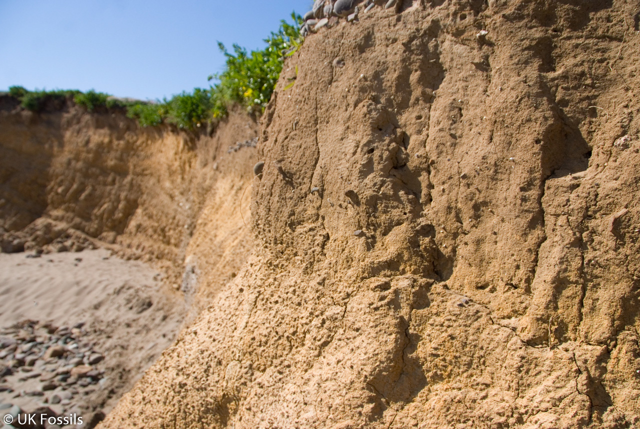
The younger shell-bearing sands are a different kind of fossil deposit. Land-snail shells may preserve delicate coils, apertures and surface ribs, but loose modern shells also reach the beach. Record whether a shell was naturally weathered from a sedimentary layer or merely found on the sand. Do not dig into dunes, buried soils or rooted profiles: their relationship to the surrounding sediment is an important part of the evidence.
A published sampled column at SS19832 02046 contains open-country land molluscs, including Cochlicella acuta, Helicella itala, Pupilla muscorum and Vallonia excentrica. The basal sample also contains the wet-ground snail Galba truncatula. These records describe one scientific column, not every sandy bank around the bay. Identifying small shells reliably often requires magnification and comparison of the aperture and sculpture, rather than shell colour alone.
The original guide’s shell exposure at SS199026, the older northern raised-beach report and the later sampled column are three distinct records. Claims of a universal Neolithic age, a single continuous shell layer or guaranteed mammal teeth should not be attached to all of them. Photograph naturally exposed shells and their context; keep fragile permitted loose finds individually wrapped rather than mixing them with hard bedrock fragments.
The better documented Gastrioceras assemblage is at neighbouring Wanson Mouth, in fault-separated Crackington Formation rocks. The original Widemouth guide’s SS1956 0127 reference, roughly 150–200 m north of the stream at Wanson, belongs to that neighbouring locality; it is preserved here as a historical field reference, not a route from the main bay or an instruction to approach the cliff base. It should not be used to promise goniatites on Widemouth’s main sandy beach. Black Rock’s strongest readily observed interest is its bedding, changing sandstone–shale proportions and deformed sediment, rather than a borrowed fauna.


A chronological record of fossil discoveries, geological research and site history at Widemouth Bay.
1901 – Early land-shell report
Kennard and Woodward reported shells associated with material described as Neolithic flakes. The limited original context and later identification doubts mean this cannot date every shell-bearing deposit at Widemouth.
1967 – Black Rock and Wanson mapped
King’s mapping documented the contrasting faulted foreshore successions, forming a basis for later structural work.
1972 – Coastal rocks and northern shells documented
A geological memoir described the coast and recorded the northern shell-bearing exposure, adding a distinct younger record to the Carboniferous geology.
1991 – Slumped sediment examined
Hartley’s work included the deformed, clast-bearing deposits at Black Rock, contributing to interpretation of sediment remobilisation.
2013 – Distinct Black Rock logs and slump structures analysed
Harper correlated five broader logs A–E and separately compared six logs of the slump and overlying beds. Analysis of 30 detached raft folds supported an interpretation of northward slump movement and a separate event from Lynstone. These are research findings, not a new field-visit claim.
2014 – A separate dune-shell column analysed
Walker documented the molluscs and sediment changes in a precisely located Widemouth column, distinguishing old land surfaces from cleaner blown sand.
2023 – Correlation problems reassessed
Craven and Lloyd examined the difficulties of linking coastal and offshore structures and strata, reinforcing the need for caution when extending local slump-bed correlations.
GEOLOGY
The rocky exposures around Widemouth principally belong to the late Carboniferous Bude Formation of the Holsworthy Group. Fine sandstone, siltstone and shale record repeated changes in sediment supply. Some layers thin laterally or end against structures, while slumped and disrupted material shows that deformation began before all the sediment had hardened. Later Variscan folding and faulting produced the steep, repeated rocks visible today.
Black Rock is particularly well studied. Five correlated local logs record a variable lower interval, a more uniform higher sandstone–shale stack and the Black Rock Slump Bed. The numbered shale markers used in this research are local correlation tools, not formal members. A traverse recording at least 120 m of strata is neither a 120 m-high cliff nor the total thickness of the Bude Formation. A separate six-log survey of the slump and its overlying beds records contrasting thickness changes across the foreshore. These two surveys use different log labels and must not be combined into an invented uniform column.
The environment of the Bude basin has been interpreted in different ways, including lake-basin sedimentation with marine incursions and marine or deeper-water models. Sedimentary structures, sparse fossils and uncertain correlations all contribute to that discussion. It is safer to explain the local sedimentary evidence than to present the entire Widemouth sequence as an uncomplicated freshwater lake deposit. At the south, the Widemouth South Fault interrupts the succession and places Black Rock’s Bude Formation against the upper Crackington rocks of Wanson.
Above and beside this much older bedrock are younger coastal sediments containing land shells and buried soils. Wind-blown sand, vegetated surfaces and wetter ground are represented in the studied mollusc column. These records must remain separate from the Carboniferous bedrock and from one another: a species-based suggestion of post-Roman deposition is not a radiocarbon date for all Widemouth sands.


Detailed geology and stratigraphy of Widemouth Bay, including the limits of local correlation.
The Black Rock logs describe bedrock at the southern end of Widemouth. The younger shell sections are separate records at distinct points. They are not joined here into a single measured column, and historical descriptions do not guarantee present exposure.
HOLSWORTHY GROUP
The Bude Formation is the principal local bedrock unit. The neighbouring Crackington Formation is juxtaposed across a fault at Wanson.
Bude Formation
The formation has a regional Langsettian–Bolsovian range. The Black Rock package contains sandstone, siltstone and shale no coarser than fine sand in the described logs. No formal member subdivision is established here.
Channel example at SS1958 0153
Harper’s Figure 4.12 calls this channel-fill succession “Log 3”. It is a separate local sedimentary log, not log 3 of the later six-log slump study. The following intervals are described from lower to higher within this small window. Their contacts and lateral changes are retained without inventing numerical sub-bed boundaries or formal members.
Channel log: deformed lower bed and ripple sandstone
At the bottom of the illustrated section, internally contorted sediment changes thickness beside early normal faults. Sandstone above it contains ripple-coset lamination and quartz veins that stop at its contact with the underlying bed. The veins and faults are secondary features, distinct from the original ripple structures.
Channel log: thinning ripple beds and massive sandstone
A further ripple-coset package thins towards the low-tide side of the foreshore. Normal faults formed during sediment accumulation cross beds and cause small thickness changes. A massive, structureless sandstone bed is also recorded below the main channel-fill interval. These observations describe local changes, not a shore-wide sequence.
Channel log: incision, draped base and fill
The channel cuts the beds beneath it. A shale-rich basal drape is followed by massive sandstone that grades from fine to very fine sand. Above lies a mud-draped, trough-cross-stratified sandstone bed, described as roughly 15–20 m wide and rapidly thinning towards low tide. That dimension is the bed’s lateral width, not its vertical thickness.
Channel log: upper ripple siltstone and shale
Laterally continuous ripple-coset siltstone overlies the thick sandstone. The upper shale contains siltstone and sandstone stringers together with bedding-parallel carbonate veins. The veins do not define a separate depositional unit or fossil band.
Five correlated logs, A–E
The longest illustrated local record, log E, includes at least 120 m of strata. Correlation uses numbered shale horizons rather than independent fossil control. Local sandstone and siltstone bodies pinch out over tens to hundreds of metres, and possible bedding-parallel fault repetition complicates the thicknesses.
Shale marker 1 and basal sandstone
Marker 1 is a lower shale reference, with a prominent sandstone above it in the correlated basal interval. The starting levels of the five logs differ; the figure must not be converted into five identical complete successions.
Shale marker 2
Marker 2 occurs within the variable interval between markers 1 and 6. Its position is a local lithological correlation, not a named marine band or an independently dated horizon.
Shale marker 3
Marker 3 is another of the shale horizons used to correlate the locally expanded lower interval. Its continuity is affected by the same onlap, truncation and pinch-out problem that changes the sandstone–shale package laterally.
Shale marker 4
Marker 4 identifies a shale interval in the author’s correlated sections, including the lower part of log A and the expanded log E. Its label does not establish that every intervening numbered horizon is present at every point.
Shale marker 5
Marker 5 is shown in the middle local logs. Together, markers 2–5 describe laterally changing relationships rather than a secure, complete numeric ladder in one exposure. The published text notes onlap or truncation, with a maximum 36 m difference between logs B and E in the marker 1–6 interval.
Growth strata between markers 1 and 6
The thickness changes are associated with local folds and faults. In particular, Harper interpreted extra sediment near the limb of fold pair 6 as filling accommodation space created while the local structure developed. Shales 3–5 pinch out between parts of logs D and E. This growth-strata interpretation is distinct from the possible, unproved additional repetition along bedding-parallel faults.
Shale marker 6 and the interval to 7a
Marker 6 forms an important higher reference. The stack between 6 and 7a has much more uniform thickness across the examined foreshore and lacks the mapped local structures or repetition of the lower interval.
Shale marker 7a
This shale underlies the Black Rock Slump Bed. The slump’s base truncates it, including lamination picked out by bedding-parallel ankerite veins. Harper considered erosion during slump movement or confinement in a channel as possible explanations. His raft-fold statistics did not establish the proposed channel-control geometry; neither explanation should be presented as settled. The shale number is a local label, not a formal member or a fossil-dated regional marker.
Black Rock Slump Bed, locally about 8–12 m
The disturbed interval lies between shale markers 7a and 7b. The initial correlated section describes about 12 m, while the separate six-log survey below records local variation from about 8 to 12 m. Displaced sandstone rafts and mud-rich sediment record early disturbance; later Variscan folding also affected the package. It cannot safely be treated as one uniformly thick regional marker.
Hartley’s type-B debris-flow interpretation
Hartley identified Black Rock as an example of his type-B deposits, interpreted as cohesive debris flows or debrites. His category description and illustrative sketch include folded or rounded sandstone clasts supported in a comparatively homogeneous, mud-rich siltstone matrix, without an overall preserved bedding fabric. Contacts are commonly sharp, with local loading possible. The regional category’s largest bed and clast measurements are not imported as measured Black Rock dimensions.
Thirty detached raft folds and transport interpretation
Harper analysed 30 detached sandstone raft folds at Black Rock. After restoring the later chevron folding, their tightly folded, curved shapes and profile directions were interpreted as evidence of northward downslope transport. The hinge elongation direction could not be directly measured there, so a geometrical proxy was used. The contrasting southward result at Lynstone led Harper to interpret separate slump events rather than one laterally continuous bed. This is an attributed structural interpretation, not a new fossil correlation.
Shale marker 7b
Marker 7b lies above the slump interval and completes the upper bracket of the author’s local succession. The presence of this label does not make the whole Bude Formation visible at Black Rock.
Six logs numbered 1–6 in Figure 5.7. These are different from the five logs A–E, the shale markers 1–7b and the channel figure’s “Log 3”. Figure 5.7 places log 1 at the eastern beach end, logs 2–4 centrally and logs 5–6 to the west. Its local thickness comparisons are described separately below.
Six-log survey: thickness of the slump
The slump is approximately 10–12 m thick in the central and eastern logs 1–4, and around 8 m in western logs 5–6. The measurements describe lateral variation across this mapped foreshore package, not different formal beds or the height of the modern cliff.
Six-log survey: black shale above the slump
Black shale deposition resumed above the disturbed sediment. This layer exceeds 1 m in the central logs 2–4 but is about 0.5 m at the eastern log 1 and western logs 5–6. These local thicknesses are not substituted for an invented regional thickness of shale marker 7b.
Six-log survey: thin siltstone and sandstone beds
Over the black shale is a stack of thinly bedded siltstone and very fine sandstone. It is about 3–4 m thick in the central logs 2–4, increasing to as much as 5 m at the eastern and western ends, logs 1 and 5–6. The changing thickness contrasts with that of the underlying slump and shale.
Six-log survey: laterally continuous sandstone cap
A laterally continuous very fine sandstone bed caps the described stack. It is about 1 m thick centrally and about 2 m towards the ends. This cap belongs to the upper-package survey and is not a new named formation or an assumed top to the entire Bude Formation.
Interpreting the contrasting thickness changes
Harper discussed two alternatives: renewed redistribution of still-mobile slump sediment towards the centre, or uneven dewatering and compaction as the overlying beds accumulated. Either could change the available space for later sediment. The geometry is described using Figure 5.7 and the consistent first paragraph of the account; a later sentence reverses the east and west log references. The guide therefore retains the observed lateral pattern without claiming that one mechanism was proved.
Mapped structural areas A1–A3
These are map areas, not stratigraphic units. Northern A1 has steep north-dipping beds and an earlier periclinal fold pair refolded by the major chevron anticline. South-eastern A2 contains a train of five upright chevron folds, three anticlines and two synclines. Central and western A3 has a more complex early fold-and-fault pattern between shale markers 1 and 6, including thrust-stacked beds and faults cutting the basal sandstone. The major chevron anticline crosses the foreshore, but the regular A2 fold train is not reproduced throughout A3.
Widemouth South Fault
The fault separates lower Bude strata at Black Rock from upper Crackington strata at Wanson. Competing models involve thrusting, later normal movement or reactivation. A regional stratigraphic separation estimate should not be published as a directly measured local fault throw. The Wanson log belongs to the separate guide.
Three records must be kept distinct. These unconsolidated sediments are not members of the Carboniferous Bude Formation.
Historical northern raised-beach record
The 1972 memoir records a 1.07 m exposure at the north of Widemouth with Cepaea nemoralis, Cochlicella acuta, Cernuella virgata and Cornu aspersum, as discussed by Walker. Its historical raised-beach classification is not a measured Holocene age.
Original UK Fossils exposure at SS199026
The earlier guide describes shell-rich sandy and clayey layers and reported cow or sheep teeth. That field record is retained as historical observation; its precise bed measurements, date and asserted continuation on Bude clifftops have not been independently confirmed. It is not equated with the later sampled column.
Walker’s column at SS19832 02046
The column is around 400 m south of the historical northern record. The following measurements are depths below the ground surface. Modern turf was not sampled; the sample boundaries are not formal stratigraphic units.
85–100 cm: basal old land surface
The 1 kg basal sample yielded 543 shells, including 80 Galba truncatula, about 15% of the total. This amphibious snail supports wet or marshy ground nearby, alongside an otherwise open-country assemblage. Walker interpreted the surface as open grassland, possibly grazed from the relative abundance of Vallonia and Pupilla. These are environmental interpretations, not direct evidence of livestock. The presence of Cernuella virgata suggested a possible post-Roman age from species history, not a radiocarbon date.
77–85 cm: cleaner blown sand
The relatively shell-poor interval, with 49 shells in the reported 1 kg sample, separates the basal land surface from the darker soil above. It is consistent with more rapid sand accumulation or a less stable surface.
40–77 cm: darker buried soil
This interval was sampled as 70–77 cm and 40–70 cm, yielding 222 and 473 shells respectively in 1 kg samples. The richer assemblages indicate a more stable surface than the intervening cleaner sand. The measurements describe this column alone.
Mollusc assemblage and age caution
The table also records Carychium tridentatum, Cochlicopa lubrica, Cochlicopa lubricella, Cochlicopa sp., Vertigo pygmaea, Pupilla muscorum, Vallonia excentrica, Punctum pygmaeum, Cochlicella acuta, Helicella itala and Cornu aspersum. The old association of shells with Neolithic flakes lacks detailed context, and the historical Candidula intersecta identification was questioned. No universal prehistoric date follows. No shade-demanding species were recorded at any sampled level, supporting an open environment rather than woodland or scrub in the sampled sequence.
References
Harper (2013), Black Rock studies: Chapters 4–5, Figures 4.12–4.15 and 5.7, especially pp. 99–104 and 178–181
Thomas M. Walker (2014), Shifting Sand: The Palaeoenvironment and Archaeology of Blown Sand in Cornwall, University of Reading PhD thesis, Chapter 3
BGS Lexicon: Holsworthy Group
BGS Lexicon: Bude Formation
BGS Lexicon: Crackington Formation
Hartley (1991), Debris flow and slump deposits from the Upper Carboniferous Bude Formation of SW England: implications for Bude Formation facies models
Craven & Lloyd (2023), Reconciling onshore and offshore geological mapping: lessons from north Cornwall, SW England, Geological Society Special Publications 541
SAFETY
The central sandy beach does not make the rocky ends safe at all tides. Both headlands and narrow margins can be cut off. Check tide times and swell, keep a clear return route and work with a low or falling tide and generous time margin. Stay outside rockfall zones.
RNLI cover at Widemouth is seasonal and applies to the lifeguarded beach area, not every remote rock exposure. Check the current RNLI information and local flags. Do not transfer that cover to Wanson Mouth.
EQUIPMENT
A camera and hand lens suit an observation visit. Wear grip-soled footwear for rock, carry tide/weather information, and use small rigid containers with separate wrapping for any permitted fragile loose shells. Picks and trowels are inappropriate for excavating the dune and soil profiles.
CLEANING AND TREATING
Keep delicate land shells dry and individually supported; do not tumble them among rocks or aggressively wash away their surfaces. Shale impressions need gentle dry brushing and gradual drying. Avoid acid, bleach and routine coatings, and retain important fish-like fragments in matrix for specialist identification.
IDENTIFY YOUR FINDS
Need help identifying a fossil? Share clear photos, where you found it and its size with the community.
FURTHER READING
Jens Lehmann (2020), Fabulous folds: Variscan tectonics in southwest England, Deposits Magazine; Millook and regional context
BGS Lexicon: Bude Formation
Harper (2013), Black Rock studies: Chapters 4–5, Figures 4.12–4.15 and 5.7, especially pp. 99–104 and 178–181
Thomas M. Walker (2014), Shifting Sand: The Palaeoenvironment and Archaeology of Blown Sand in Cornwall, University of Reading PhD thesis, Chapter 3
Hartley (1991), Debris flow and slump deposits from the Upper Carboniferous Bude Formation of SW England: implications for Bude Formation facies models
Craven & Lloyd (2023), Reconciling onshore and offshore geological mapping: lessons from north Cornwall, SW England, Geological Society Special Publications 541
Cornwall Council: Widemouth Bay car park, EX23 0AW
Poundstock Parish Council: Widemouth public-toilet maintenance
South West Coast Path: Widemouth facilities on the Whalesborough Hare Walk
ACCESS RIGHTS
The southern coastal exposures are within Boscastle to Widemouth SSSI; do not assume that the designation covers every part of the main or northern bay. Follow current access and landowner notices.
Public access does not authorise removal or excavation. Observe the beds and shell profiles in place, with small loose collecting only where current rules allow. Do not hammer bedrock, dig dunes or damage rooted buried-soil sections.
Original guide’s designation document (historical copy; check current notices and the official site record above): SSSI Information – Widemouth Bay
It is important to follow our ‘Code of Conduct’ when collecting fossils or visiting any site. Please also read our ‘Terms and Conditions‘
LINKS
♦ Fossil Discussions
♦ Fossil Articles
♦ Buy Fossils, Tools and Equipment
♦ Buy Crystals, Meteorites, and Artefacts
♦ Join Fossil Hunts
♦ UK Fossils Network


