
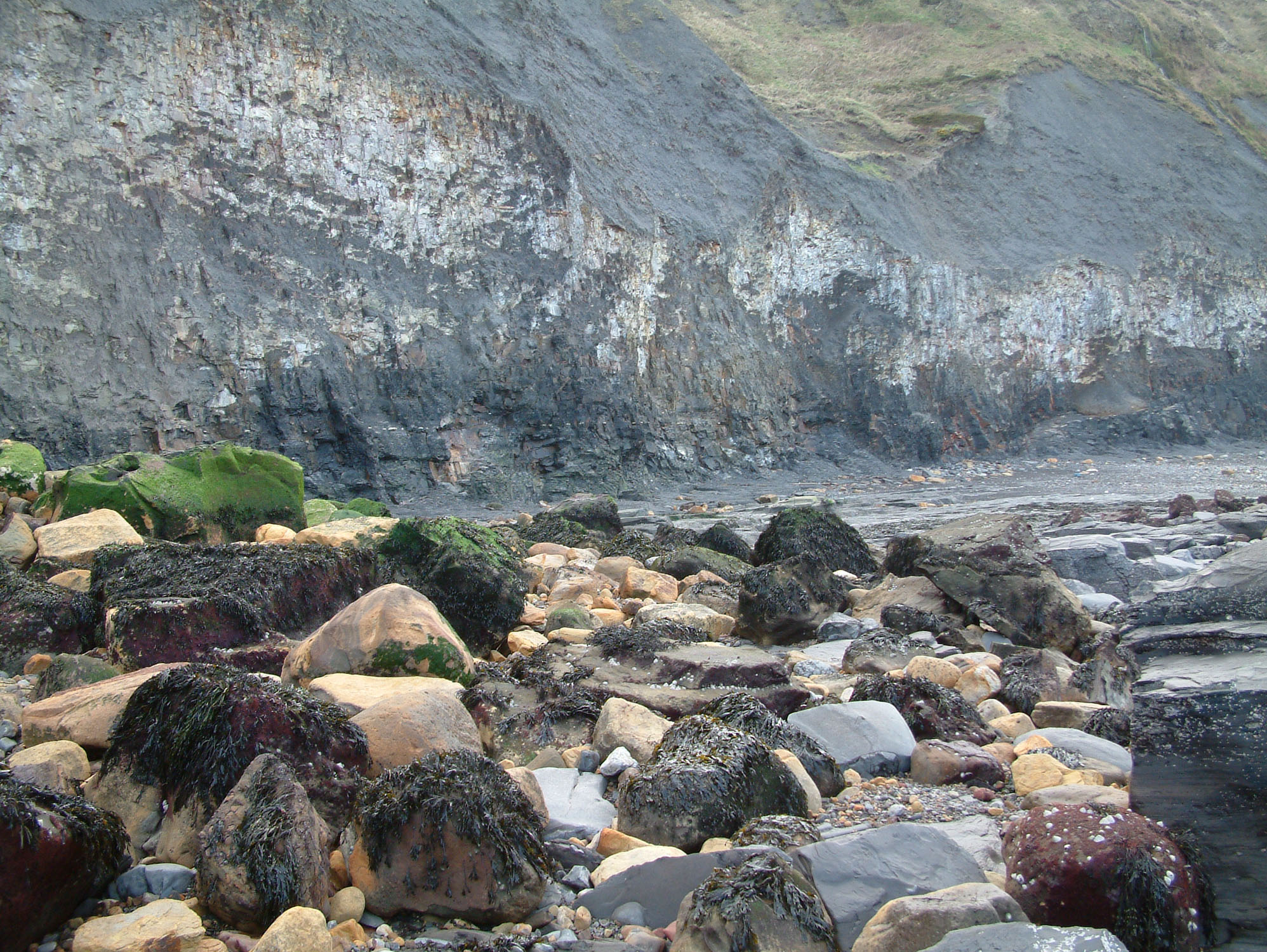
Port Mulgrave is one of the most productive fossil sites on the Yorkshire Coast, famed for its abundant ammonites and rich Jurassic marine fauna. Once a thriving ironstone mining harbour, the foreshore now yields a wide range of fossils, including reptile remains, belemnites and nodules packed with ammonites, often exposed after cliff falls and erosion. With its combination of historical interest and exceptional fossil potential, it remains a must-visit location for serious collectors.


FIND FREQUENCY: ♦♦♦♦♦ – Port Mulgrave yields excellent ammonites and dinosaur/reptile remains can also sometimes be found. However, there is quite a lot of competition. The best time to collect is after winter storms or scouring conditions.
CHILDREN: ♦♦ – Due to the difficult walk down to the beach, this location is not suitable for young children, but is acceptable for mature family groups.
ACCESS: ♦♦ – You can park at the top of the cliff top and there is a very long way down to the beach by an endless number of steps. ENSURE PARKING SPACES ARE LEFT AVAILABLE TO LOCAL PEOPLE.
TYPE: Most fossils can be found on the foreshore, especially after storms or scouring conditions, within nodules or loose in the shingle. However, fossils are also commonly seen in the cliff and on the scree slopes, either in nodules or loose.
DIRECTIONS
♦ Head towards Hinderwell and you will see a turnoff to the east towards Port Mulgrave. Follow the road all the way down, which will veer northwards and lead to a small parking area just past some houses. The road reaches a dead end at some houses.
♦ Park in the area by the side of the road. This parking area has been made available by the kind permission of the locals. However, it is essential that parking spaces are left available for local people and their families. If it looks like the parking area is becoming a little crowded, especially at weekends and during the summer holidays, park in The Badger and Hounds car park in Hinderwell, where you will be warmly received for a pint after some hard work fossilling. Ensure you keep the area clean and tidy, and park sensibly.
♦ Access can be made to the beach by a footpath leading down the high cliff. Note that there are many steps to climb down (and back up).
♦ Ref: Postcode to car park: TS13 5LD, Google Maps
♦ What3Words: ///mango.extra.manuals
DOWNLOAD THE UKF BOOKLET TO FOSSIL HUNTING AT PORT MULGRAVE
VIDEO FILM
FOSSIL HUNTING
From the beach steps at Port Mulgrave, both ends of the bay are productive for fossil collecting, with each area offering something slightly different. The combination of frequent cliff falls, storm exposure and a wide foreshore makes this one of the most exciting and varied fossil sites along the North Yorkshire coast.
At the north end of the bay, just beyond the remains of the old harbour works, fossiliferous nodules can be found at beach level and scattered across the foreshore. These hard, rounded concretions often contain ammonites in excellent condition, many preserved with fine ribbing and strong keels. Species commonly encountered here include Dactylioceras commune, recognised for its evenly spaced ribbing, and larger forms such as Hildoceras bifrons, which displays elegant, sweeping ribs and a more compressed shell form. Careful splitting of nodules can reveal beautifully detailed specimens, often with both halves present.
Further north, towards the landslip area, plant material becomes more common. Fossilised remains of horsetail plants, belonging to the genus Equisetites, can sometimes be found preserved within shale blocks. These represent vegetation that once grew on nearby land and was washed into the Jurassic sea, where it became buried and fossilised. Their segmented stems and jointed appearance make them distinctive among the otherwise marine fossil assemblage.
The middle section of the bay is particularly notable for vertebrate remains. This is the area from which many reptile and occasional dinosaur specimens have been recovered. After strong storm tides, bones may be visible in the cliff face just above eye level or washed out onto the foreshore below. These remains often belong to marine reptiles such as ichthyosaurs and plesiosaurs, though isolated bones are more commonly found than complete specimens. Fragments of dinosaur bone have also been discovered here, likely washed out from terrestrial deposits and reworked into the marine sediments.
When searching this central stretch, focus on areas of shingle and freshly fallen shale. Fossils frequently accumulate in these natural traps after erosion. Ammonites can often be found loose amongst the debris, sometimes already weathered free from their nodules.
The south side of Port Mulgrave, around the small adjoining bay, is particularly rich in ammonites. Many specimens found here are exceptionally well preserved, often retaining crisp rib detail. In addition to Dactylioceras species, collectors may encounter Eleganticeras elegantulum, a smaller but finely ornamented ammonite, as well as other Liassic forms depending on the precise layer exposed. Reptile remains can also be found in this southern area, although they are less frequently encountered than in the central section of the bay.
Port Mulgrave offers a wide range of fossil types beyond ammonites. Brachiopods such as Terebratula punctata can be found within certain layers, distinguishable by their symmetrical shells. Bivalves and other molluscs are also present, along with occasional fish remains, including scales and isolated bones. Belemnites may be discovered weathered free from softer shale, appearing as smooth, bullet-shaped guards.
Successful collecting here relies on carefully examining nodules and scanning exposed rock surfaces for ammonites just “peeping” out from the stone. Often only a small section of ribbing or the curve of a whorl is visible. These specimens can usually be prepared and cleaned further at home, revealing far more detail once the surrounding matrix is carefully removed.
As always at Port Mulgrave, take care beneath unstable cliffs and remain aware of tide times. With patience and attention to fresh exposures, this locality can yield some of the most diverse and rewarding finds on the Yorkshire coast.


Some of the most significant fossil discoveries and scientific milestones from Port Mulgrave include the earliest classic work on the Yorkshire Lower Jurassic succession, its later importance as part of the Staithes to Port Mulgrave reference section, the historic Cleveland Ironstone industry, and its long reputation for ammonites, marine reptiles and other Lower Jurassic fossils.
1822–1828 – Young and Bird established the classic early geological framework for the coast that includes Port Mulgrave
One of the earliest major scientific milestones for Port Mulgrave came with the work of Young and Bird on the Yorkshire Jurassic coast. Their studies helped establish the fossil-rich Lower Jurassic succession of this stretch of coast in the geological literature and laid the foundations for later work on the ammonites, ironstones and reptile-bearing beds of the Port Mulgrave area.
1829 – John Phillips published the classic early account of the Yorkshire Lower Jurassic
Phillips provided one of the key early frameworks for the Lower Jurassic of the Yorkshire coast, including the succession represented around Port Mulgrave. This became one of the main starting points for later stratigraphic and palaeontological work on the locality.
1876 – Tate and Blake published sections that underpinned later work on the Port Mulgrave succession
The studies of Tate and Blake became the basis for much of the later geological understanding of the Upper Pliensbachian and Lower Toarcian beds along this part of the coast. Port Mulgrave forms part of that classic research stretch between Staithes and Kettleness.
1892 – Fox-Strangways reviewed and synthesised the classic early work on this coast
By the late nineteenth century, the geology and fossil-bearing beds of the Staithes–Port Mulgrave coast had become important enough to be drawn together in Geological Survey work. This helped cement the scientific importance of the locality within the Yorkshire Jurassic succession.
1920 – the Cleveland Ironstone industry highlighted the industrial importance of the Port Mulgrave succession
Port Mulgrave and the adjoining coast were historically important for ironstone mining. By 1920, many millions of tonnes had been extracted from the Main Seam in Cleveland, and ore from Port Mulgrave was shipped to the smelters of Tyneside. This underlines the huge industrial as well as geological importance of the fossil-bearing succession exposed here.
1955 – Howarth produced the stratigraphic framework later used for the Port Mulgrave beds
Howarth’s detailed work on the Yorkshire Lower Jurassic provided the framework for the beds exposed around Port Mulgrave, including the Cleveland Ironstone succession and overlying Whitby Mudstone units. His work underpinned much of the later modern interpretation of the coast.
1992 – Rawson and Wright reinforced the importance of the Staithes to Port Mulgrave coast
Modern synthesis work treated the coast that includes Port Mulgrave as one of the best British sections through the Upper Pliensbachian to Lower Toarcian succession. This confirmed the scientific importance of the locality not only for fossil collecting, but also for Jurassic stratigraphy.
1990s – Port Mulgrave was recognised within the type section for major Jurassic formations
Modern Geological Conservation Review work confirmed the wider coast from Staithes to Port Mulgrave as the type section for the Staithes Sandstone Formation, the Cleveland Ironstone Formation and the Penny Nab Member. This gave Port Mulgrave a direct place in the formal framework of British Jurassic geology.
Modern understanding – Port Mulgrave remains a classic Lower Jurassic fossil locality
Today Port Mulgrave is best known for ammonites, belemnites, bivalves and trace fossils from the Cleveland Ironstone and Whitby Mudstone succession, together with occasional marine reptile remains from the wider Staithes–Port Mulgrave coast. Its importance lies in combining strong collecting potential with major stratigraphic significance on one of Britain’s key Lower Jurassic reference sections.
GEOLOGY
Port Mulgrave exposes a particularly important section of Lower Jurassic strata within the Cleveland Basin. The sequence here Port Mulgrave exposes an important sequence of Lower Jurassic strata within the Cleveland Basin, spanning the upper Pliensbachian (Middle Lias) into the Toarcian (Upper Lias), deposited approximately 185–180 million years ago. These rocks record a significant environmental shift from relatively shallow, iron-rich marine conditions into deeper, oxygen-poor settings, which plays a key role in both the geology and the exceptional fossil preservation at this location.
At the northern end of the site, particularly around Brackenberry Wyke, the Cleveland Ironstone Formation is well exposed within a large landslip complex. This part of the sequence is made up of alternating mudstones, siltstones and ironstone bands, deposited in cycles reflecting changing conditions on the Jurassic seabed. The formation is divided into the Penny Nab Member at the base and the overlying Kettleness Member, both of which can be seen within slipped blocks and foreshore exposures. The ironstone seams formed under specific chemical conditions, where reduced sediment input and changes in oxygen levels allowed iron to concentrate. These beds represent a shallow to moderately deep marine shelf environment, and occasional plant remains within the ironstone indicate that material from nearby land was periodically washed into the sea.
Moving southwards across the site, the sequence passes into the Whitby Mudstone Formation, which dominates much of the foreshore and cliffs. This transition marks a shift into quieter, deeper marine conditions where finer sediments accumulated. The lower part of this formation, represented by the Grey Shale Member, is exposed on the foreshore north of the old harbour and within Rosedale Wyke. These fine-grained mudstones were deposited in relatively low-energy offshore conditions and often contain concentrated fossil assemblages. Belemnites can occur in dense accumulations, sometimes forming “belemnite battlefields”, while bivalves and other shells are commonly found grouped in small clusters, representing death assemblages formed by rapid burial or current activity.
Further south, the cliffs and foreshore expose the Mulgrave Shale Member, one of the most significant units at Port Mulgrave. These dark, bituminous shales were deposited in deeper water under low-oxygen (anoxic) conditions, which greatly enhanced fossil preservation. Within this unit lies the well-known Jet Rock, historically worked for jet, a compact material formed from fossilised wood. Remains of the old jet workings and harbour structures are still visible, linking the geology directly to the industrial history of the area.
The Mulgrave Shales are particularly important because they yield many of the most notable fossils from the site. The combination of fine sediment and anoxic conditions allowed for the preservation of ammonites within nodules, as well as marine reptile remains, including ichthyosaurs and plesiosaurs. Occasional terrestrial material, including dinosaur remains, is also found, likely washed out from nearby land and incorporated into the marine sediments.


Port Mulgrave is a composite upper Pliensbachian to lower Toarcian shore section extending from Old Nab and Brackenberry Wyke round the old harbour into Rosedale Wyke. It is one of the classic Yorkshire coast localities for the upper Cleveland Ironstone, the Port Mulgrave reference section of the Grey Shale Member, the type Mulgrave Shale Member Jet Rock succession, and the Pliensbachian–Toarcian boundary interval.
Port Mulgrave should not be forced into a single straight cliff log. The usable section is composite, with the best bedrock exposures on the foreshore and cliff-foot ledges from Old Nab through Brackenberry Wyke to the harbour and then eastward into Rosedale Wyke; small faults repeat some horizons near the harbour, and large slipped Middle Jurassic sandstone blocks locally obscure the cliff foot. Older Staithes Sandstone and the lower part of the Penny Nab Member lie west toward Penny Nab and Staithes and are not forced into the main Port Mulgrave log here.
Formal Howarth bed numbers are retained wherever they are published. In the boundary interval between the Cleveland Ironstone Formation and the Grey Shale Member, the original numbering is awkward, with Beds 58–60 followed upward by Beds 1–32, and that published usage is kept exactly.
LIAS GROUP
Cleveland Ironstone Formation (Upper Pliensbachian)
Cleveland Ironstone Section Character At Port Mulgrave
At Port Mulgrave the Cleveland Ironstone is best exposed from Old Nab through Brackenberry Wyke. The Main Seam reaches the foreshore here, the upper ironstone cycles stand out as orange-brown ledges against the darker shales, and old workings, adits and quarry scars are common. The Port Mulgrave section is therefore especially valuable for the upper part of the formation, while the lower Penny Nab and Staithes Sandstone beds are better seen westward toward Penny Nab and Staithes.
Penny Nab Member
Beds 27–31 — Subnodosus Interval And Avicula Seam (c. 7.1 m)
This interval forms the lowest substantial Cleveland Ironstone section used on the Port Mulgrave shore. Beds 27–30 are silty sandstone, siltstone and shale with bands of calcareous concretions and a shell bed containing Protocardia truncata, Entolium and other bivalves; ammonites include Amaltheus subnodosus, A. striatus and A. margaritatus, especially in the lowest nodule band, and the neotype of A. subnodosus came from this interval. Above lies Bed 31, the Avicula Seam, a fine-grained ironstone with pale green chamositic ooids and a mudstone parting in places, rich in bivalves, especially Oxytoma cygnipes, and with many protocardiid burrows. Together these beds represent the upper part of a storm-influenced shallow-marine shelf succession in which silty and sandy sediment was repeatedly capped by condensed iron-rich horizons.
Beds 32–35 — Gibbosus Shales And Raisdale Seam (c. 5.25 m)
Beds 32–34 are siltstone and shale with pyritic masses low in the interval and a calcareous concretion band 1.25 m above the base. These concretions yield Amaltheus gibbosus and the shale above yields Amauroceras ferrugineum; the base of Bed 32 was proposed as a parastratotype for the base of the Gibbosus Subzone. Bed 35, the Raisdale Seam, is a thin ironstone with many Protocardia truncata and rare Amaltheus cf. margaritatus. Fine lamination beneath the seam in the classic “upper striped bed” facies and the recurrent erosive contacts show repeated storm reworking, brief quiescent muddy sedimentation and renewed condensation into ironstone at the top of the cycle.
Beds 36–40 — Two Foot Seam And Upper Penny Nab Mudstones (c. 3.8 m)
Beds 36–38 are shale with a belemnite-rich band at the top and a concretionary ammonite horizon about 1.1 m above the base; these yield Amaltheus gibbosus, A. margaritatus, Pseudoamaltheus engelhardti and Amauroceras ferrugineum. Bed 39 is the Two Foot Seam, an ironstone with rare Amaltheus ex gr. margaritatus and Pseudoamaltheus engelhardti, and Bed 40 is the overlying shale with crushed Amaltheus gibbosus. This is the top of the Penny Nab Member at Port Mulgrave, a condensed ironstone-capped shallowing cycle with ammonites, belemnites and locally well-preserved crinoid remains in the mudstones.
Total Exposed Penny Nab Member In The Port Mulgrave Section: About 16.15 Metres, Representing The Upper Part Of The Member From The Subnodosus Interval Upwards
Kettleness Member
Kettleness Member Character
The base of the Kettleness Member is a minor erosion surface at the base of the Pecten Seam, locally with phosphatic pebbles. The Transiens and Salebrosum zonules are absent, so there is a real non-sequence between the Penny Nab and Kettleness members, and the upper part of the Cleveland Ironstone becomes less obviously cyclic than the lower part.
Beds 41–50 — Ferruginous Shale And Pecten Seam (c. 1.55 m)
Bed 41 is a ferruginous shale with a basal bivalve shell bed. Above it, Beds 42–50 form the Pecten Seam, an ironstone developed in five bands with shale partings and local shell beds. Pseudopecten equivalvis is especially characteristic, and the seam forms a conspicuous hard ledge in the Port Mulgrave scars. This is a very condensed lower Kettleness interval deposited under shallow marine conditions with repeated pauses in clastic sedimentation and renewed ironstone development.
Beds 51–54 — Black Hard Shale And Main Seam (c. 2.9 m)
Bed 51 is a black hard shale separating the Pecten Seam from the Main Seam. Beds 52–53 form the Main Seam bottom block, a thick ironstone divided by shale; burrows are present and ammonites are uncommon but include forms close to Pleuroceras paucicostatum. Bed 54 is the Main Seam top block, a conspicuous ironstone crowded with branching burrows and concentrations of rolled fossils. Ammonites include Pleuroceras paucicostatum, P. elaboratum, P. apyrenum, Amauroceras ferrugineum and A. lenticulare, and it has yielded the unique Yorkshire record of the Tethyan hildoceratid Canavaria aff. cultraroi. At Old Nab the Main Seam was mined by pillar-and-stall workings, and marine erosion now exposes spectacular scratch-marked Rhizocorallium on the old stall floors, with Chondrites on intervening pillars.
Beds 55–57 — Hawskerense Shales And Upper Ironstone (c. 1.9 m)
Bed 55 is the Hawskerense Shale, with common Pleuroceras hawskerense; Bed 56 is a thin unnamed ironstone with an irregular top, also yielding P. hawskerense and very rare Protogrammoceras turgidulum; Bed 57 is the top sandy micaceous shale, again with P. hawskerense. These beds form the top of the Cleveland Ironstone Formation and show renewed muddy shelf sedimentation interrupted by one last thin iron-rich horizon. The Hawskerense fauna makes this interval especially important for the uppermost Spinatum Zone in Yorkshire.
Total Thickness Of Kettleness Member At Port Mulgrave: About 6.35 Metres
Total Exposed Cleveland Ironstone Formation In The Port Mulgrave Section: About 22.5 Metres From Beds 27–57, With The Lower Part Of The Formation Better Seen Westward Toward Penny Nab
Whitby Mudstone Formation (Lower Toarcian)
Grey Shale Member
Grey Shale Member Section Character At Port Mulgrave
Port Mulgrave is the reference section for the Grey Shale Member, which is fully exposed on the foreshore and in low cliff-foot sections from Brackenberry Wyke into Rosedale Wyke. The member is dominated by grey shaly mudstones with repeated nodule bands, many weathering red. The site is also crucial biostratigraphically: the type locality of Dactylioceras tenuicostatum lies here, and several bed bases within the member have been proposed as stratotype or parastratotype levels for lower Toarcian subzones.
Beds 58–60 And 1–3 — Sulphur Band And Pliensbachian–Toarcian Boundary Interval (c. 1.77 m)
Bed 58, the Sulphur Band, is a finely laminated pyritic shale with many jet lenticles and forms the base of the Whitby Mudstone Formation. Above it, Beds 59–60 are grey shale with a row of calcareous concretions at the top, yielding Pseudopecten equivalvis and Pholadomya; Beds 1 and 2 are grey to dark grey laminated and locally bituminous shales, still essentially boundary beds with no unequivocal typical Toarcian fauna. Bed 3, however, is the first level at which the earliest typical Toarcian ammonites occur regionally, including Protogrammoceras paltum and indeterminate Dactylioceras, and on current criteria the base of Bed 3 is the most defensible level for the Pliensbachian–Toarcian boundary even though earlier workers placed the boundary lower, at the base of the Sulphur Band. This thin interval is therefore one of the most important stage-boundary tracts on the Yorkshire coast.
Beds 4–17 — Six Red Nodule Beds (c. 2.75 m)
These pale grey-weathering shales contain six rows of calcareous and sideritic concretions, many weathering distinctly reddish brown and traceable across the foreshore. Belemnites and bivalves are present, and this is the conspicuous lower Grey Shale concretionary package first encountered at Brackenberry Wyke. The interval records quiet offshore mud deposition with repeated early diagenetic concretion growth in an only partly oxygenated seabed.
Bed 18 — Crosbeyi Bed (0.38 m)
A grey shale with small calcareous concretions and frequent Dactylioceras crosbeyi. The base of Bed 18 was proposed as a stratotype or parastratotype for the base of the Clevelandicum Subzone. This is a classic ammonite-rich biohorizon in the lower Toarcian succession at Port Mulgrave.
Beds 19a–19c — Clevelandicum Interval (c. 1.27 m)
The interval comprises laminated bituminous shale below, a very thin shale with red-weathering lenticles and common Dactylioceras clevelandicum in the middle, and grey shale above. It captures a short phase of more organic-rich sedimentation at the base, followed by the distinctive clevelandicum biohorizon. Although thin, this interval is biostratigraphically crucial in the Yorkshire lower Toarcian.
Beds 20–27 — Tenuicostatum Nodular Shales (c. 2.75 m)
Grey shales with several bands of small calcareous nodules and a basal double band of large calcified lenticular masses weathering red. Well-preserved Dactylioceras tenuicostatum is common in the small nodules, and the neotype of the species came from Bed 22. Higher calcareous nodules from this part of the section also yield belemnite guards and may contain sphalerite crystals. The base of Bed 20 was proposed as a stratotype or parastratotype for the base of the Tenuicostatum Subzone, making this one of the most internationally useful ammonite levels at Port Mulgrave.
Beds 28–31 — Semicelatum Dogger-Bearing Shales (c. 3.55 m)
Grey shales with three bands of large calcareous concretions, including a pyritic double row at the base. These nodules yield well-preserved Dactylioceras semicelatum, large belemnites and the nautiloid Cenoceras, and the base of Bed 28 was proposed as a stratotype or parastratotype for the base of the Semicelatum Subzone. The large doggers stand out clearly on the Port Mulgrave foreshore and record repeated early cementation within otherwise soft offshore muds.
Bed 32 — Antiquum Shell-Bed Interval (1.85 m)
A grey shale with occasional flat calcareous nodules and shell beds, especially near the base, where crushed Tiltoniceras antiquum may be abundant. Dactylioceras semicelatum and the pelagic bivalve Bositra radiata also occur. This bed forms the top of the Grey Shale Member and records a fossil-rich offshore mudstone phase immediately below the onset of the darker, more organic-rich Jet Rock facies.
Total Thickness Of Grey Shale Member At Port Mulgrave: About 14.3 Metres
Mulgrave Shale Member
Mulgrave Shale Member Section Character At Port Mulgrave
Port Mulgrave is the type locality of the Mulgrave Shale Member. At the cliff foot beyond the Sheep Stones the Grey Shale Member passes up transitionally into dark laminated pyritic shales rich in hydrocarbons. Freshly broken rock may smell strongly of oil, benthonic fauna are almost absent through much of the section, and the member includes the famous Jet Rock with its giant concretion bands and jet horizons.
Bed 33 — Cannon Ball Doggers (0.15 m)
A narrow but unmistakable row of spherical calcareous concretions up to about 0.18 m across at the base of the member. They yield abundant and often beautifully preserved Elegantuliceras elegantulum, including macroconchs and microconchs, and they mark the sharp lithological change from the non-bituminous Grey Shale below into the bituminous Jet Rock above.
Bed 34 — Elegantulum Shales (2.7 m)
Grey bituminous shale with frequent calcareous concretions and common Elegantuliceras elegantulum. The shale is darker, more pyritic and more organic-rich than the Grey Shale Member below. This bed forms much of the lower Jet Rock and records dysoxic to anoxic offshore mud accumulation with early concretion growth around fossils and organic nuclei.
Bed 35 — Whalestones (0.9 m)
Large ovoid calcareous concretions, some up to about 3 m long, together with numerous smaller concretions including the Lower Pseudovertebrae, all set in grey bituminous shale. Cleviceras exaratum is common, with less frequent Harpoceras serpentinum and Phylloceras heterophyllum. This is one of the most spectacular concretionary horizons on the foreshore and a classic Port Mulgrave marker bed.
Bed 36 — Exaratum Shales (1.08 m)
A grey bituminous shale with characteristic Cleviceras exaratum, representing part of the exaratum biohorizon. It continues the low-oxygen organic-rich facies of the Jet Rock and is an important ammonite interval between the giant concretion rows of the Whalestones and Curling Stones.
Bed 37 — Curling Stones (0.3 m)
A row of spheroidal calcareous concretions with pyritic skins, commonly up to about 0.45 m across. Fossils include Cleviceras elegans, Harpoceras serpentinum, Dactylioceras semiannulatum, D. crassoides and Phylloceras heterophyllum. These doggers are among the most famous Port Mulgrave concretions and were left piled on the shore during former jet working.
Bed 38 — Upper Pseudovertebrae Shales (1.54 m)
Grey bituminous shale with occasional concretions, the Upper Pseudovertebrae lying about 0.3 m above the base. Cleviceras elegans, Harpoceras serpentinum and occasional Phylloceras heterophyllum occur. The bed represents continued organic-rich offshore deposition under strongly reduced bottom conditions.
Bed 39 — Top Jet Dogger (0.23 m)
A continuous argillaceous limestone band capping the main lower Jet Rock concretionary interval. It contains Cleviceras elegans and dactylioceratids and forms the roof of many old jet adits. Rare masses of hard jet occur in the 3 m of beds below this level, making it one of the most collector-relevant horizons at Port Mulgrave.
Bed 40 — Millstones (0.3 m)
Giant lenticular calcareous concretions, seen from above as large rounded “millstones”, set in grey bituminous shale. Fossils include Cleviceras elegans, Hildaites murleyi and dactylioceratids, sometimes as shell concentrations. The bed marks the upper part of the elegans biohorizon and is one of the most distinctive foreshore markers in the Port Mulgrave Jet Rock.
Bed 41 — Lower Bituminous Shales (c. 5.9 m At Port Mulgrave)
Grey to dark grey bituminous shale above the Millstones, with crushed Harpoceras ex gr. falciferum, probably including forms referable to H. mulgravium, together with pyritized and flattened ammonites, Pseudomytiloides dubius and Bositra radiata. Calcareous concretions may contain Harpoceras falciferum, and rare specimens have been reported with oil preserved in their chambers. The base of Bed 41 at Port Mulgrave is effectively a parastratotype for the base of the Falciferum Subzone. These shales are strongly reducing, hydrocarbon-rich source-rock facies with almost no benthonic fauna.
Higher Bituminous Shales And Top Of The Mulgrave Shale Member
East of the harbour, toward High Lingrow and in the adjacent cliffs, the Mulgrave Shale Member continues upward above Bed 41. This upper part is less well exposed as a safe measured foreshore log than the Jet Rock below, but it includes further dark laminated bituminous shales with pyrite and soft jet and must pass up into the topmost sideritic Ovatum Band below the Alum Shale Member. At Port Mulgrave this uppermost boundary interval is represented mainly in cliff and eastern bay exposures rather than in one clean shore platform.
Lower Exposed Mulgrave Shale Member At Port Mulgrave: About 13.1 Metres From Beds 33–41, With Higher Bituminous Beds Continuing Eastward And Up Into The Cliffs
Alum Shale Member
Lower Alum Shale Interval Above Rosedale Wyke
The Alum Shale Member is exposed in the cliffs above Rosedale Wyke just beyond Port Mulgrave rather than as a full clean foreshore section. Its lower beds are grey, non-bituminous shales with calcareous concretions and red-weathering sideritic bands corresponding to the Hard Shales and lower Main Alum Shale. Fossils include ammonites, bivalves and belemnites, but the member is much less hydrocarbon-rich than the Mulgrave Shale below. These beds were worked historically for alum, and the Port Mulgrave coast formed part of that long Yorkshire alum industry.
Upper Alum Shale And Top-Lias Overstep
Higher in the cliff the Alum Shale becomes softer and paler in its middle part and more concretionary again in the upper Cement Shale levels. At Port Mulgrave, however, the upper Toarcian succession is not preserved as a full accessible coastal log. The main significance of the locality is that younger beds are overstepped here, so the Middle Jurassic cap rests directly on the Alum Shale Member in the Port Mulgrave area, unlike the fuller Blea Wyke–Peak successions farther south-east.
RAVENSCAR GROUP
Saltwick Formation (Aalenian)
Sheep Stones And Slipped Saltwick Sandstones
At the south-eastern end of Brackenberry Wyke and beyond, large fallen and slipped blocks of medium- to coarse-grained deltaic sandstone from the Saltwick Formation obstruct the foreshore. Some of these isolated blocks stand on shale pedestals and are known as the Sheep Stones. They show that non-marine Middle Jurassic channel and delta-plain sandstones cap the cliffs above the Lower Jurassic shales. In the main Port Mulgrave coast section these are not part of a reliable upright measured log, but they are important because they show the overstepping Middle Jurassic cover above the Alum Shale and explain the persistent sandstone blockfall on the shore.
Ammonite Zonation And Stratigraphic Significance
The Port Mulgrave section spans the upper part of the Pliensbachian Amaltheus subnodosus and A. margaritatus interval in the upper Penny Nab Member, passes through the Spinatum Zone of the Kettleness Member with the Pleuroceras hawskerense fauna at the top, and then records almost the entire lower Toarcian succession from the Sulphur Band and the Paltus Subzone through the Clevelandicum, Tenuicostatum and Semicelatum subzones of the Grey Shale Member into the Exaratum and Falciferum subzones of the Mulgrave Shale Member. Because several bed bases here were proposed as stratotype or parastratotype levels and because the locality is the type area for Dactylioceras tenuicostatum, Port Mulgrave remains one of the most important British reference localities for the upper Pliensbachian–lower Toarcian ammonite succession.
Depositional Environment
The Port Mulgrave succession records a major environmental shift across the upper Pliensbachian and lower Toarcian. The upper Cleveland Ironstone Formation represents repeated shallow-marine, storm-influenced shelf cycles in which silty and sandy marine sediments were capped by condensed berthierine–siderite ooidal ironstones during pauses in clastic input and episodes of shoaling. The Grey Shale Member records renewed marine transgression into quieter offshore mud deposition, still with abundant ammonites and repeated concretion growth. The Mulgrave Shale Member then marks much more strongly reducing, bituminous and pyritic offshore conditions, with the Jet Rock and Bituminous Shales forming a classic hydrocarbon-rich black-shale succession with almost no benthonic fauna. Above that, the Alum Shale Member represents return to less bituminous grey marine mudstone sedimentation before later erosion and overstep by non-marine Middle Jurassic Saltwick sandstones.
Total Thickness Covered Here
The main Port Mulgrave shore section from Old Nab through Brackenberry Wyke and Rosedale Wyke covers about 22.5 m of upper Cleveland Ironstone, about 14.3 m of Grey Shale Member, and at least 13.1 m of lower Mulgrave Shale Member, giving more than 50 m of closely controlled Upper Pliensbachian to Lower Toarcian succession before the higher Bituminous Shales, Alum Shale and slipped Saltwick cap are added. It is therefore one of the best Yorkshire localities for following the change from seam-bearing shallow-marine ironstone cycles into the classic lower Toarcian black-shale and jet-bearing facies.
References
Howarth, M.K. (1955). Domerian of the Yorkshire Coast.
Howarth, M.K. (1962). The Jet Rock Series and the Alum Shale Series of the Yorkshire Coast.
Howarth, M.K. (1973). The stratigraphy and ammonite fauna of the Upper Liassic Grey Shales of the Yorkshire coast.
Howarth, M.K. (1992). The ammonite family Hildoceratidae in the Lower Jurassic of Britain.
Howard, A.S. (1985). Lithostratigraphy of the Staithes Sandstone and Cleveland Ironstone formations (Lower Jurassic) of north-east Yorkshire.
Hesselbo, S.P. & Jenkyns, H.C. (1995) on the Staithes–Port Mulgrave Lower Jurassic succession and sequence stratigraphy.
Rawson, P.F. & Wright, J.K. (eds) (2000). The Yorkshire Coast. Geologists’ Association Guide No. 34.
Simms, M.J. and co-authors (2004). British Lower Jurassic Stratigraphy, Geological Conservation Review Series No. 30, including the Staithes to Port Mulgrave account.
British Geological Survey Lexicon entries: Cleveland Ironstone Formation, Grey Shale Member, Mulgrave Shale Member, Alum Shale Member, Saltwick Formation and Staithes Sandstone Formation.
Page, K.N. Geological Conservation Review account: Staithes to Port Mulgrave.
SAFETY
Common sense when collecting at all locations should be used and knowledge of tide times is essential. It is easy to get cut off at Port Mulgrave, as the sea always reaches the base of the cliff. You should ensure you return in good time. Also be aware of sticky areas on the slippages, as it is easy to get stuck especially after rain. After heavy rainfall, the steps down to Port Mulgrave can be extremely slippery, so extra care is needed.
EQUIPMENT
At Port Mulgrave, a keen eye and patience are essential, as fossils can occur within nodules on the foreshore, in fallen shale from cliff slips, or occasionally protruding from exposed bedrock. A geological hammer (16–24 oz) and flat chisel are recommended for carefully splitting siderite nodules, while a lump hammer may be useful for larger, tougher concretions; however, controlled, precise blows are always preferable to avoid damaging specimens. Eye protection should be worn at all times when striking rock, and sturdy boots with good grip are vital due to uneven shale, loose shingle and potentially slippery surfaces. As parts of the bay are affected by tides and unstable cliffs, always remain aware of your surroundings and avoid working directly beneath overhangs. Wrap any finds securely in paper or bubble wrap and store them in a solid container to prevent breakage on the walk back.
CLEANING AND TREATING
Begin by removing any loose sediment very carefully using a soft toothbrush. Take your time, as many fossils—particularly pyritic specimens—are fragile and easily damaged. Once cleaned, fossils should be desalinated by soaking them in fresh water for at least 24 hours to remove residual salt. After soaking, allow specimens to dry naturally at room temperature. Do not dry them on radiators or other heat sources, as rapid drying can cause cracking or long-term damage.
Once fully dry, we recommend sealing fossils with Paraloid B-72, dissolved in acetone. This is a museum-grade consolidant that is widely available in pre-mixed bottles. Paraloid B-72 is stable, long-lasting, and does not yellow or react chemically over time. Importantly, it is also fully reversible, making it suitable for scientifically important or display-quality specimens.
Some collectors prefer to treat ammonites with artists’ varnish. This is acceptable for common species that are not of scientific importance, as it enhances colour and contrast and can make a specimen really “pop”. However, varnish is not reversible and is therefore not recommended for rarer or research-grade fossils.
DISCUSSIONS
Port Mulgrave or anywhere around the area? (Dec 2025)
Hello, Has anyone made a trip recently to Port Mulgrave or Kettleness? Just wondered if there is still a direct route down to...
Port Mulgrave strange fossil?
Very slim pickings this morning. Managed to get a quick visit via a work trip. Saw this on the left had side of the...
Port Mulgrave - Parking
Hi all, I plan on going to Port Mulgrave soon for the first time in about 9 years. From memory there is a...
Is Port Mulgrave accessible now?
Hello Everyone! I was wondering if any of you knows if Port Mulgrave is accessible now (May 2024)? I read the path was closed...
Nodule - Port Mulgrave Beach
Hi All, the other day I came across this interesting nodule on the beach at Port Mulgrave, near Whitby, N Yorkshire. Does anyone have...
Port Mulgrave Nodule
The other day I found this interesting nodule on the beach at Port Mulgrave. Does anyone have any ideas as to what it might...
Found at Port Mulgrave ID please
📷 I’ve been collecting at port for many years now and this is a first for me thanks in advance ( it’s about 20mm...
Port Mulgrave Nodule
Hi everyone, Found this at Port Mulgrave. Split it and found this little Dactylioceras Commune? I know there's lots of different Dacs. Not going...
Port Mulgrave, Ichthyosaur Jaw Segment
Hello All, I was out at Port Mulgrave a few days ago and found this, pretty sure it's part of an ichthyosaur jaw. Teeth...
Port Mulgrave tooth
Hello, We would like to know what animal this tooth could come from. We found it in Port Mulgrave, UK It is 3.5 cm...
ARTICLES
- The dinosaur footprints of Whitby (Part 2): Problems matching footprints to dinosaurs
- The dinosaur footprints of Whitby (Part 1): Introduction
ACCESS RIGHTS
This site is a site of special scientific interest (SSSI). This means you can visit the site, but hammering the bedrock is not permitted. For full information about the reasons for the status of the site and restrictions, download the PDF from Natural England.download the PDF from Natural England.
It is important to follow our ‘Code of Conduct’ when collecting fossils or visiting any site. Please also read our ‘Terms and Conditions‘
LINKS
♦ Fossil Discussions
♦ Fossil Articles
♦ Buy Fossils, Tools and Equipment
♦ Buy Crystals, Meteorites, and Artefacts
♦ Join Fossil Hunts
♦ UK Fossils Network


