Watchet is a highly productive Jurassic location, well known for its reptile remains and abundant ammonites. The foreshore also reveals impressive geological features, including spectacular faulting and large ammonite casts, making it both scientifically important and visually striking. With regular fresh material exposed by erosion, it is a must-visit site for fossil collectors exploring this part of the Somerset coast.


FIND FREQUENCY: ♦♦♦♦♦ – Watchet is very productive, but the best time to collect is during scouring conditions on the foreshore. Many reptile remains can be collected just west of Warren Bay.
CHILDREN: ♦♦♦♦♦ – This location is suitable for family trips and for young children, as fossils can be found on the foreshore.
ACCESS: ♦♦♦ – Access to the beach at Watchet can be achieved usually by parking in the town and walking from Watchet Harbour along the beach. However, if you want a more direct route, head for Warren Bay Campsite, just outside Watchet and park there. Follow the footpath directly to Warren Bay.
TYPE: Watchet is a foreshore and cliff location, so fossils can be found in both. However, the vast majority are found in rocks on the foreshore or exposed during scouring tides.
DIRECTIONS
♦ ACCESS 1: There is a car park near the small museum in the centre of Watchet, next to the harbour. The museum contains examples of locally found fossils (including an ichthyosaur skeleton) and books illustrating the fossils and strata of the area. Postcode: TA23 0AN
♦ Take the narrow footpath running next to the steam railway line (with the sea on your left hand side) and follow it up onto the cliff top. After a pleasant walk (of about half a kilometre), you reach a long set of steps onto the beach (with a good handrail).
♦ Once on the beach, head away from the lighthouse The rocks around the lighthouse are all Triassic and unfossiliferous.
♦ ACCESS 2: You can park along the promenade at Blue Anchor, walking East, go past Blue Anchor point and round the corner the Jurassic rocks start. Postcode: TA24 6JR
♦ ACCESS 3: From Blue Anchor (Note: The road from Watchet to Blue Anchor is now permanently closed), access the coastal road to Warren Bay Campsite which is just before the old road is closed off. Park at bottom of the campsite (with permission at reception), and access the beach from the middle of the bay. The concrete slope can be steep and sometimes slippery. Postcode: TA23 OJR
♦ What3Words to the main collecting site: ///handrail.remaining.confining
DOWNLOAD THE UKF BOOKLET TO FOSSIL HUNTING AT WATCHET
VIDEO FILM
FOSSIL HUNTING
Watchet is a bit of an unpredictable location. Sometimes, you can come away with nothing and other times buckets full. Much depends on beach conditions, but always take the right tools. It is also a good location for collecting bones from plesiosaurs and ichthyosaurs, although fresh cliff falls are often required. The bone in the photo was found in a bolder on the foreshore.
Bivalves, including scallop shells, oysters and Gryphaea are also common at Watchet and crinoid slabs are common around Warren Bay. Many ammonites can be found, although they are mainly broken, unless you are lucky enough to arrive after a fresh cliff fall. They can be found scattered on the foreshore, but are usually just fragments. However, occasionally, you will get an ammonite in a small nodule or, if lucky, a complete ammonite that has fallen out of its nodule.
The second prime location for ammonites is at the location from where most of the bones are found, that is, past the major fault which has been undercut by the sea where the Lias starts again. Ammonites are also often found in the fine shingle heading towards Blue Anchor. The rock (shale) in the bottom layer is extremely soft and wet, and fractures into fine sheets when stressed. In some areas, this shale contains imprints of ammonites (up to 30cm in diameter). A number of small whole and sections of larger pearly ammonites can also be found from this layer scattered around on the rock platforms.


Rocks from the Triassic Blue Anchor bone bed can also be found, which contain fish, reptile and shark remains. There are two main locations where bones can be found, although, generally, they can be found anywhere on the foreshore. The first is from the foreshore where the entrance to the camp site is, stretching west, until you reach the red Triassic beds. The second is when you reach the massive fault that the sea always reaches (which is notable for the algae and overhangs). Beyond this point, the Lias begins again just before Blue Anchor. This is the main location from where bones are found. The bones come from the top part of the cliff, and they often fall and can be picked up from the foreshore.
Between Warren Bay and Blue Anchor, there is a large Triassic rock in the middle of the foreshore. If you search along the foreshore around this area, crinoid slabs can be found. The yellowish limestone blocks surrounding the steps originate from the cliff and are rich in a variety of bivalves, including scallop shells, oysters and Gryphaea. The rock is quite hard but, if you search the foreshore around the blocks, you can find well preserved shells, especially oysters and Gryphaea buried in the sand.
Rock platforms extend along most of the foreshore. At certain times of the year, they become buried in sand and/or mud deposits and can be difficult to access.
Do not venture onto soft mud or follow the retreating waterline in search of fossils. Search accessible loose material on firm ground, keep clear of cliff bases and allow ample time to return before the tide cuts off the route. Local reports have included instances of finding whole crinoids (although these do not appear to feature in the rocks further along the foreshore).
Ammonites are also often found within the fine shingle heading towards Blue Anchor. Some preserve a delicate pale or pearly shell on laminated shale. Search loose material rather than chiselling sheets from the rock platform: the local collecting code prohibits hammering the bedrock. Keep fragile finds supported in their matrix and protect them in a rigid container. Seek preparation advice before washing, coating or drying unstable shale specimens.
The rock in the top layer of the photograph showing the bedding structure lacks fine bedding planes and is much easier to handle. In some areas, it contains white ammonites or imprints of them.

Scientific milestones for Watchet’s western shore and Warren Bay, with the provenance limits of an important historical Watchet specimen made explicit.
1970 and 1975 – detailed foreshore mapping west of Watchet
A. Whittaker mapped the Blue Anchor–Watchet foreshore in detail. This work distinguished fault-bounded Triassic and Jurassic outcrops and supplied the field framework later incorporated into the BGS Minehead memoir.
1999 – BGS publishes the western Watchet geological framework
R. A. Edwards’s Minehead memoir documented the Watchet Fault, Warren Bay structures and local fossil-bearing Lias exposures. Its mapped divisions and individually scoped sections remain valuable for understanding why a short shore traverse crosses repeated or missing intervals.
2008 – plesiosaur rib found near Warren Bay
Watchet Market House Museum records a plesiosaur rib found near Warren Bay in 2008, together with vertebrae and coprolites attributed to the same species. The museum account does not establish that all the material came from one individual.
2012 – Eoplesiosaurus antiquior named from historical Watchet material
Benson, Evans and Druckenmiller named Eoplesiosaurus antiquior from the postcranial skeleton TTNCM 8348 in the Somerset collection. The paper gives Watchet as its provenance and regards a lowermost Hettangian age as likely; it does not identify a precise Warren Bay findspot or measured bed. It is an important early plesiosaur record for the district.
GEOLOGY
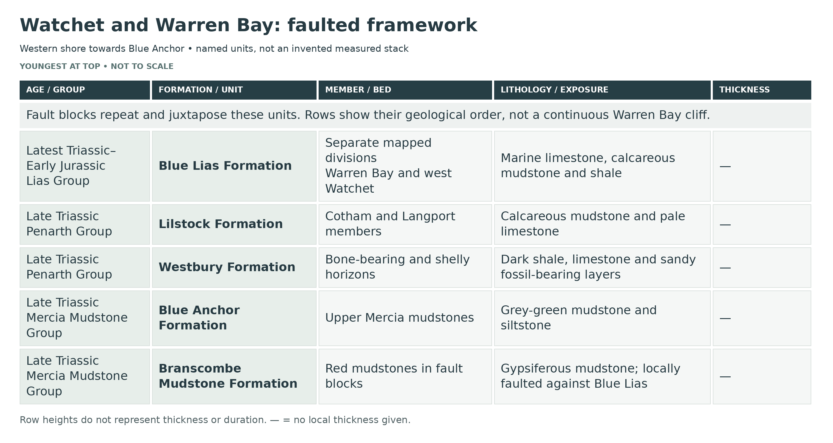
Watchet’s western shore, from the harbour through Warren Bay towards Blue Anchor, exposes faulted and folded Late Triassic and Early Jurassic rocks. Red and green Mercia Mudstone beds, the marine Penarth Group and limestone–mudstone rhythms of the Blue Lias are brought beside one another in different fault blocks. Their changing resistance to erosion helps form the cliffs and shore platforms. The detailed section below distinguishes the western exposures from the separate eastern Watchet–Doniford reference sections.
The oldest rocks seen around Watchet belong to the upper part of the Mercia Mudstone Group, a package dominated by red-brown mudstones and siltstones that records predominantly continental conditions in Late Triassic time. These fine-grained sediments accumulated on very low-relief ground, in environments that repeatedly swung between shallow water and exposure. In practical terms, that history is written into the rocks as blocky, structureless mudstones punctuated by reduction patches, thin sandier beds, desiccation features and abundant evaporite minerals. Gypsum occurs widely as nodules and veins, and the chemistry of the sediments points to restricted drainage and evaporation—exactly the kind of setting in which saline lakes, mudflats and sabkha-like plains can form. Around Watchet, these Mercia Mudstone beds are important not just as “the red clays in the cliffs”, but because they provide the mechanically weak, clay-rich foundations that encourage slope instability and help focus later faulting and deformation along the coast.
Up-section, the Mercia Mudstone Group becomes noticeably paler and greener as it passes into the Blue Anchor Formation, a distinctive unit that is famous on the west Somerset coast. The Blue Anchor Formation is dominated by grey-green to pale green dolomitic mudstones and siltstones, commonly with thin, hard, buff-coloured dolomitic beds and with features such as lamination, mudcracks, occasional halite pseudomorphs and locally abundant gypsum. This is a key transition interval: it represents the waning of strongly oxidising “red-bed” conditions and the growing influence of brackish to marine waters at the very end of the Triassic. The coastal exposures between Blue Anchor and Watchet are especially important because they show the full character of these “tea-green” and grey marls and how they grade upward into the next major environmental shift.
That next shift is the Rhaetian marine transgression recorded by the Penarth Group. At its base sits the Westbury Formation, typically a dark, organic-rich succession of mudstones or shales with thin limestones, sandstones and distinctive fossil-rich horizons commonly referred to as bone beds. In environmental terms, the contrast with the underlying Blue Anchor Formation is dramatic: the Westbury Formation marks the establishment of persistent marine conditions, with repeated reworking during storms and sea-level fluctuations producing shelly and bone-rich layers. Above it lies the Lilstock Formation, which captures a more variable, shallow-water story. Its lower part (the Cotham Member) includes grey-green mudstones, siltstones and sandstones formed in very shallow lagoons and tidal-flat settings that could periodically dry out, while the upper part (the Langport Member, historically known in many places as the “White Lias”) includes fine-grained, porcellanous limestones and calcareous mudstones representing very shallow shelf-lagoon environments. This Penarth Group succession is central to Watchet’s geological significance because it records the step-by-step switch from continental evaporitic plains to fully marine sedimentation just before the Jurassic began.
The boundary interval between the Triassic and Jurassic is exceptionally well displayed near Watchet, especially at St Audrie’s Bay a short distance to the east, and along nearby foreshore sections. Here, subtle changes in lithology and fossil content become globally important: the transition from Penarth Group sediments into the lowermost Lias Group includes beds that have long been debated and intensively studied because they sit right at the system boundary. The international base of the Jurassic is fixed at the Kuhjoch GSSP in Austria, using the first occurrence of Psiloceras spelae tirolicum; it is not simply the first appearance of any Psiloceras or a change in rock type at Watchet. In the Watchet area, the earliest Jurassic ammonites (notably Psiloceras planorbis) are historically significant and help anchor interpretations of where the boundary lies within the classic “Blue Lias” style succession. The result is that the Watchet coast is not only fossil-rich, but also a place where the fine detail of sedimentation, sea-level change and early Jurassic biotic recovery can be read directly from the rocks.
The lowest Jurassic strata in this area are part of the Lias Group, and the best-known unit within it is the Blue Lias Formation: a rhythmic alternation of limestones and calcareous mudstones or siltstones, with individual limestone beds commonly decimetre-scale in thickness. This alternation reflects repeated environmental or chemical shifts in shallow marine conditions, producing beds that weather into characteristic ledges and steps on the foreshore. The Blue Lias is also one of the key fossil-bearing units around Watchet and the wider north Somerset coast, known for ammonites and bivalves and for occasional vertebrate remains. Above the Blue Lias, the succession becomes more mudstone-dominated in formations such as the Charmouth Mudstone, reflecting changes in sediment supply and water depth across the Early Jurassic seas. Together, these rocks turn the coast into a natural cross-section through time, where bedding rhythms, fossil horizons and subtle changes in colour or carbonate content can be followed laterally for long distances.
Faulting is particularly striking west of Watchet. The BGS describes the Watchet Fault as a strike-slip fault with reverse movement; nearby older faults were also reactivated and folded. East of the main fault, red Mercia Mudstone in the lower cliff is juxtaposed against Blue Lias above, so their apparent superposition is not a normal depositional contact. Folds and smaller faults interrupt the foreshore reefs, while landslips further disturb the cliffs. Gypsum occurs in the Triassic rocks, but its presence alone does not demonstrate that salt flow caused the coastal folds and faults.
Coastal processes then sculpt these rocks into the landforms people see. The Bristol Channel is highly tidal, and the repeated wetting and drying of broad intertidal areas encourages the development of extensive shore platforms on softer mudstones and interbedded limestone–mudstone successions alike. Around the Blue Anchor–Watchet–Lilstock stretch, platforms can be remarkably wide, and their surfaces often reflect the bedding architecture: limestones form more resistant ribs and low scarps, while mudstones weather into gentler, muddier benches. Where mudstones dominate, the platforms can be smoother and more easily cut back, but they are also prone to slumping and landsliding where waves undercut the base of cliffs. Cliff heights and platform widths vary along the coast according to rock type, structure and exposure to wave energy, producing a patchwork of bays, headlands and stepped foreshore profiles rather than a single uniform coastal form.
Finally, the modern surface cover adds a last layer of complexity. Valley bottoms and stream mouths contain alluvium—sands, gravels and silts laid down by rivers—while slopes can be mantled by head deposits formed by downslope movement of weathered material, especially under periglacial conditions during colder phases of the Quaternary. Landslip and colluvial deposits accumulate where clay-rich mudstones fail along slip planes, sometimes triggered by coastal erosion or heavy rainfall. These superficial materials can mask bedrock locally, but they also help explain why some parts of the Watchet coast are easier to access than others, why fresh fossil-bearing falls can appear after storms, and why cliff management is a continuing issue in a town built right at the edge of a rapidly changing shoreline.
The same geology has also shaped local building traditions across Somerset. The thin-bedded limestones of the Blue Lias, and the finer, pale limestones traditionally called White Lias in parts of the region, have been widely used as building and walling stones, valued for their ability to split into slabs and blocks but also known for characteristic weathering patterns. While Watchet’s coastal cliffs are best known to geologists for their boundary stratigraphy, fossils and structures, they sit within a county-wide story in which the Mesozoic rocks have long supplied practical materials for construction, lime and flooring. In that sense, Watchet’s geology is both globally significant in stratigraphic terms and locally influential in the everyday fabric of the built environment.
Taken together, the geology of Watchet is a compact but unusually rich record of change: arid continental mudflats giving way to a rapid marine incursion, shallow lagoons and tidal flats transitioning into fully marine Early Jurassic seas, and all of it later fractured and folded by fault movement. Few places offer such accessible exposures of the Triassic–Jurassic transition alongside such vivid structural features and coastal landforms, which is why the Watchet coast remains a classic destination for both fossil hunters and stratigraphers.


Detailed geology of Watchet’s western shore and Warren Bay, with separately labelled regional bed correlations and nearby Helwell fossil horizons.
Section Architecture And Bed Numbers
The guide’s main collecting reach is west of Watchet through Warren Bay towards Blue Anchor. Folding, faulting and landslips put different parts of the succession beside one another. The former W1–W16 labels and their generic cycle thicknesses were not a verified measured log and are not retained as individual beds. Published Whittaker–Green bed numbers and BGS mapped divisions are used where their locality and correlation are supported.
MERCIA MUDSTONE GROUP
Branscombe Mudstone Formation
Red Mudstones In Fault Blocks
Red-brown gypsiferous mudstone forms parts of the lower cliff west of Watchet. Around the Watchet Fault and towards West Street Beach, it is faulted against Blue Lias in the upper cliff. The apparent superposition along a particular face can therefore be structural rather than an undisturbed depositional contact.
Blue Anchor Formation
Grey-Green Blue Anchor Beds
The upper Mercia succession contains grey-green dolomitic mudstone and siltstone, with laminated beds and evaporitic minerals. Blue Anchor Point is a separate type exposure farther west. Its Rydon and Williton subdivisions provide regional context, but their complete measured thicknesses must not be copied into every Watchet fault slice.
Rydon Member — western Watchet cliff markers
BGS identifies the gypsiferous marker units A, B and C in the largely inaccessible cliff at ST 0600 4331, just west of the Watchet Fault. Their positions were measured from photographs using a suspended scale. These are exact western-locality observations, distinct from the complete type log at Blue Anchor. Grey and green mudrocks host gypsum nodules and veins; their presence does not establish a salt-flow origin for the major coastal faults.
Unit A — lower gypsum marker
The marker occurs approximately 28.35 m below the top of the Blue Anchor Formation in this western Watchet cliff. The memoir correlates it with Unit A elsewhere, but the detailed type-section bed thickness is not imposed on this exposure.
Unit B — gypsum-rich interval, approximately 1.83 m
The base lies about 22.25 m below the formation top. It is one of the distinctive nodular-gypsum-rich intervals used to correlate these faulted cliff exposures with the type section.
Unit C — gypsum-rich interval, approximately 2.74 m
The base lies about 10.68 m below the formation top. Like Unit B, this is a measured local gypsum-rich marker, not an inferred thickness for the entire Rydon Member.
Williton Member — upper Blue Anchor context
The upper Blue Anchor succession passes into the more marine-influenced Williton Member. The BGS account records grey shale with fine sand and silt layers, and published observations at Watchet include silt-streak beds with desiccation cracks near the member’s top. Its full thickness is not independently fixed for each western fault block here; the thicker regional and Blue Anchor type-section totals remain separate.
PENARTH GROUP
Westbury Formation
Bone-Bearing And Shelly Shale–Limestone Succession
Dark shale, thin shelly limestone and sandy vertebrate-bearing horizons represent the Rhaetian marine transgression. Penarth beds occur on the northern limb of the faulted Warren Bay structure. The approximately 13.9 m Westbury measurement reported for Watchet in the BGS regional account is tied to the section just east of the harbour; it is not a western-cliff height.
Lilstock Formation
Cotham Member
Calcareous Mudstone And Deformed Beds
Green-grey calcareous mudstone, siltstone and thin sandstone distinguish the Cotham from the darker Westbury below. Disturbed bedding and desiccation-crack horizons are described in the Watchet–Doniford sections, recording shallow-water sedimentation and periods of exposure. Their precise geometry varies between exposures.
Langport Member
Pale Limestone, Sun Bed And Upper Muddy Interval
Fine pale limestone and grey calcareous mudstone form the top of the Penarth Group. The Sun Bed is a useful upper limestone marker; marly beds intervene before the basal fissile Blue Lias in the BGS coastal framework. “Watchet Beds” has been used with different boundaries historically, so the old name alone does not fix a formation or time boundary.
LIAS GROUP
Blue Lias Formation
Local Fault-Block Distribution
The BGS maps divisions 1–4 in faulted Warren Bay reefs, while divisions 1 and 2 occur around West Street Beach and the harbour. Between Blue Anchor and the Watchet Fault, slipped mudstone-rich intervals and more limestone-rich exposures occur repeatedly. These are real mapped packages, unlike the former invented progression of increasingly thick “limestone cycles”.
Basal Blue Lias And Traditional Pre-planorbis Beds
Calcareous mudstone, shale and sparse limestone overlie the Penarth interval. The basal Blue Lias is not synonymous with the Jurassic time boundary: the formation includes a latest Triassic component in the regional scheme. Bivalves are characteristic, while the earliest ammonite horizons occur higher. A single complete basal thickness is not imposed on Warren Bay.
Bed 8 And Bed 9: Earliest Ammonite Context
In the published east-Watchet reference succession, bed8 yields early Psiloceras and bed9 yields Neophyllites. These genuine numbered correlations provide context for low Hettangian rocks, but the detailed occurrences should not be claimed for every loose ammonite found west of the harbour.
Bed 14: Echinoid-Bearing Shale At Helwell Bay
Page and Paul’s measured fossil interval is a 5–10 cm shale at the top of bed14 at Helwell Bay, east of Watchet harbour. It contains small crushed Diademopsis with associated spines, Psiloceras of the planorbis group, the bivalves Modiolus minimus and Anningella?, a crinoid stem assigned to Isocrinus angulatus? in the figured specimen caption, a decapod and rare plant fragments. This retains the useful fossil record while distinguishing it from Warren Bay.
Bed 18: Second Echinoid Horizon At Helwell Bay
A smaller number of articulated echinoids occurs in bed18 of the same eastern locality. Greater disarticulation and alignment in some specimens suggest more disturbance than in the bed14 assemblage. The two horizons must remain individually recognised, rather than being relabelled as generic limestone cycles.
Bed 24: Laminated Ammonite Mudstone
The regional lower Planorbis succession includes a conspicuous indurated laminated mudstone with crushed nacreous Psiloceras. Historical Watchet specimens may derive from this bed or other nearby low Hettangian levels; old locality labels rarely establish a unique bed. The specific 2 m-or-more measurement belongs to the published regional log, not a new Warren Bay measurement.
Bed 25, Beds 36–37: Johnstoni Subzone Context
The incoming of Caloceras marks the published bed25 boundary. Beds36 and37 are separate laminated-mudstone fossil horizons associated with Caloceras johnstoni and C. intermedium in the regional framework. The BGS confirms Johnstoni-age rocks east of Blue Anchor Cliff, but these records do not make an uninterrupted bed-by-bed traverse across every intervening fault.
Higher Hettangian And Lower Sinemurian Packages
Mudstone-rich and limestone-rich divisions continue above the low Hettangian beds. Schlotheimia characterises upper Hettangian regional intervals, followed by arietitid ammonites in the Sinemurian. BGS divisions3 and4 occur in western fault blocks, but regional zonal thicknesses and the full numbered coastal succession are not a single Watchet cliff log.
Nearby Helwell Cenoceras Beds: Separate Locality Context
The nautilid-rich bed228 and higher bed231 described at Helwell Bay belong to a different, higher local exposure east of Watchet. They are useful comparisons, but are not evidence for a measured upper Warren Bay “W15” horizon. The Helwell guide contains their detailed local treatment.
Depositional Environment And Preservation
The Blue Lias alternation records marine mud deposition and carbonate accumulation, subsequently modified by cementation. Dark laminated shale commonly preserves flattened ammonites, whereas harder carbonate horizons can preserve shells differently. Fossil concentration, bottom-water oxygenation and later mineral growth vary between beds; no single environmental explanation fits every limestone–shale couplet.
Thickness And Correlation Limits
No defensible 20–35 m “collector breakdown” can be derived from the former W-numbered sequence. The published BGS maps and correlated coastal sections should be used instead. Beach sediment, folds, faults and landslips interrupt the section, and a loose block’s position does not establish its original horizon.
MERCIA MUDSTONE GROUP — WESTERN FAULT-BLOCK OBSERVATIONS
Cliff Near ST 0660 4348
The BGS describes approximately 6 m of lower gypsiferous mudstone and about 6–10 m of overlying red mudstone here. These are local exposure intervals, not an undisturbed formation total.
Promontory Near ST 0681 4353
The lower 8–10 m is mainly red mudstone with green beds no more than about 0.2 m thick; approximately 5 m of greyer and greenish strata lies above. This local colour succession must not be confused with the whole regional Blue Anchor type section.
LIAS GROUP — WESTERN LOCAL RECORDS
Blue Lias Formation
Upper Cliff Near ST 0660 4348
The source records up to 20 m of grey shale with six limestone beds about 0.1–0.3 m thick. Fault juxtaposition against the Mercia Mudstone below is part of the geological explanation, so this is not a normal depositional contact.
Local Ammonite Records West Of The Harbour
BGS records Waehneroceras and Laqueoceras near ST 0670 4365 and Schlotheimia near ST 0643 4346. Published Psiloceras planorbis occurrences also include large fallen blocks farther west; a fallen block is not a measured in-place bed and is treated accordingly.
Measured Western Liasicus Log: BGS Figure 32, Column 2
This is the genuinely western foreshore section at approximately ST 069 437, immediately west of Watchet harbour, measured by A. Whittaker in 1970. It is a split graphical log, read down the first column and then through its continuation. The entries below describe its successive lithological packages from youngest to oldest. The diagram supplies no individual bed numbers or printed thicknesses for these packages, so neither is invented. Its other columns, at Blue Anchor and east of Watchet, are not imported here.
Upper Limestone Cap
A thin limestone caps the plotted section near the queried Angulata boundary.
Upper Grey Mudrock
Grey shale and mudstone lie directly below the cap.
Waehneroceras–Laqueoceras Interval
Dark grey shale and mudstone carry both ammonite genera in the source plot.
Grey Mudrock Below The Faunal Interval
A separate greyer shale–mudstone package leads down to a thin limestone marker.
Thin Limestone Marker
A narrow carbonate horizon separates the upper and middle muddy packages.
Thick Waehneroceras Mudrock
A substantial grey mudrock package carries a plotted Waehneroceras record.
Waehneroceras And Questioned Caloceras Level
A succeeding muddy interval is labelled Waehneroceras and ?Caloceras; the question mark is retained.
Dark Mudrock Package
A darker shale–mudstone package follows beneath that faunal level.
Grey Mudrock Package
Greyer shale and mudstone separate two darker intervals.
Lower Waehneroceras Interval
Another dark mudrock package has an independently plotted Waehneroceras occurrence.
Nodule-Bearing Grey Mudrock
A thick greyer interval includes sparse limestone nodules towards its lower part.
Thin Dark Mudrock
A narrow darker band interrupts the surrounding greyer mudrock.
Lower Grey Mudrock
Another grey shale–mudstone package occurs above the base of the first graphic column.
Basal Dark Package Of First Column
Dark shale and mudstone complete the first drawn column; the log then continues in the adjacent narrow column.
Continuation: Grey Mudrock With Nodules
The top of the continuation column contains grey shale and mudstone with isolated carbonate nodules.
Continuation: Thin Dark Band
A narrow dark shale band separates adjacent grey packages.
Continuation: Grey Mudrock
A further greyer mudrock interval precedes the next dark ammonite-bearing package.
Continuation: Dark Waehneroceras Package
Dark shale and mudstone contain a plotted Waehneroceras occurrence near their lower part.
Lowest Plotted Grey Mudrock And Nodules
Grey shale and mudstone with several nodular carbonate levels form the oldest part of this western Liasicus log.
References
Edwards (1999), BGS Minehead memoir
Whittaker & Green (1983), Weston-super-Mare memoir
GCR30 BlueAnchor–Lilstockcoast
Page & Paul (2017), articulated echinoids near Watchet
ICS: Hettangian GSSP
BGS Lexicon: Blue Lias
SAFETY
Common sense when collecting at all locations should be used and knowledge of tide times is essential. You can easily be cut off by the tide as the sea always reaches parts of the cliff, especially if walking from the harbour at Watchet or from Blue Anchor. The tide comes in very high at these two locations.
In addition, the foreshore at Watchet is subject to periodic thick mud deposits, which submerge much of the rock platforms and render the foreshore quite dangerous to walk on. Warning signs are posted when relevant at the top of the cliff path.
EQUIPMENT
Most fossils can be found by simply searching along the foreshore, they tend to mostly be found loose amongst the shingle. Occasionally fossils can be found in large blocks, so it is ideal to take a hammer and chisel just in case.
CLEANING AND TREATING
Keep fragile shells, bones and shale supported in their matrix. Gently remove loose grit only where the surface is sound. Do not soak every fossil for a fixed period: pyrite, marine salts and clay-rich matrix need different treatment. Avoid heating or rapid drying, and seek advice before treating a wet, flaking or crumbling specimen.
Paraloid B-72 can help selected fragile areas after testing, but sound fossils do not automatically need sealing. Although the resin can be redissolved, complete removal from porous matrix is not guaranteed. Record any treatment and seek advice for important specimens.
Avoid routine decorative varnishing. A coating may change the appearance of the shell and obscure fine detail; formulations also differ in their ageing and removability. Photograph the untreated fossil and assess whether any conservation treatment is actually necessary.
IDENTIFY YOUR FINDS
Need help identifying a fossil? Share clear photos, where you found it and its size with the community.
FURTHER READING
Deposits – Fossils of the West Somerset coast
Deposits – Jurassic fossil cephalopods preserving aragonite shells
Deposits – Watchet Market House Museum, Somerset
Geological Conservation Review – Blue Anchor–Lilstock Coast
Watchet Market House Museum – Fossils
Love Watchet – Fossil Collecting Code
ACCESS RIGHTS
This locality lies within the Blue Anchor to Lilstock Coast SSSI. The local Fossil Collecting Code allows a few representative fossils from loose material or fallen blocks; do not hammer the bedrock or cliffs or use rock saws. Leave large fossils in place and report unusual finds. Obtain permission before collecting on private land. See the existing SSSI information for the site’s geological interest.
It is important to follow our ‘Code of Conduct’ when collecting fossils or visiting any site. Please also read our ‘Terms and Conditions‘
LINKS
♦ Fossil Discussions
♦ Fossil Articles
♦ Buy Fossils, Tools and Equipment
♦ Buy Crystals, Meteorites, and Artefacts
♦ Join Fossil Hunts
♦ UK Fossils Network