Robin Hood’s Bay is one of the most geologically important sites on the Yorkshire Coast, known for its diverse ammonite fauna and extensive Jurassic exposures. While much of the central bay is covered by boulder clay, the foreshore and reefs to either side can be highly productive. Success here depends on conditions and experience, but with careful searching, a wide range of ammonites and other marine fossils can be found.


FIND FREQUENCY: ♦♦♦ – Robin Hood’s Bay yields excellent ammonites, but you need to work for these. The best area to collect from is the north side.
CHILDREN: ♦♦ – Due to the dangerous access to this location, young children should not visit this site.
ACCESS: ♦♦♦ – You should park at the top of the cliff and there is a footpath down to the beach.
TYPE: Most fossils can be found on the foreshore, within nodules or loose. Fossils are also commonly seen in the cliff, on the scree slopes, and in the rocks and boulders.
DIRECTIONS
♦ At Robin Hood’s Bay village, you can park in either the small car park at the top of the hill or the second larger one just a short walk away.
♦ From here, the best end to visit is the north side. You will find a footpath at the top of the hill, to the left of the main street leading to the beach. This winds round and passes a picnic area.
♦ You can also visit the south and middle part of the bay. To do this, go down into the main street at the bottom of the hill and follow round to the right. You will see some steps, which follow the sea defence and lead to the shore.
♦ Ref: Postcode to car park: YO22 4QN, Google Maps
♦ What3Words: ///trainer.dupe.imagined
VIDEO FILM
FOSSIL HUNTING
Robin Hood’s Bay is one of the most diverse and geologically significant fossil localities on the Yorkshire coast. The wide sweep of the bay exposes a long and varied succession of Jurassic rocks, making it a highly rewarding—though sometimes challenging—site for collectors. The sheer range of fossil species found here, combined with extensive wave-cut platforms and frequent cliff falls, means that patience and persistence are often well rewarded.
Most fossils are found either within foreshore exposures during scouring conditions, inside fallen rocks and nodules, or freshly revealed after cliff collapses. Unlike some other Yorkshire locations, it is relatively uncommon to find well-preserved fossils simply lying loose on the beach. Successful collecting usually involves careful searching, splitting nodules and examining exposed reef surfaces at low tide.
The best conditions for fossil hunting are typically after winter storms, when heavy seas strip away sand and clay, exposing fresh rock and releasing fossil-bearing nodules from the cliffs. During calmer periods, particularly in summer, sand can build up and cover productive layers, making finds less frequent.


The north side of the bay is often the most productive, especially following cliff falls. Fallen shale and mudstone blocks commonly contain nodules, many of which yield well-preserved ammonites. Species found here include Platypleuroceras, a broad, strongly ribbed form, Tropidoceras, recognised by its pronounced keel, Acanthopleuroceras, often displaying coarse ribbing or spined whorls, and Androgynoceras, which shows variation in ribbing through its growth stages. When properly prepared, these ammonites can display excellent detail.
Large bivalves such as Pinna are also found, sometimes referred to as pen shells. These long, wedge-shaped shells lived partially buried in soft sediment. While complete specimens are uncommon, fragments are regularly encountered and can still be impressive in size.
At very low tide, extensive reef platforms are exposed across the centre of the bay. These calcareous shales are highly fossiliferous and provide excellent in situ exposures. Ammonites such as Arnioceras, with its strong, evenly spaced ribbing, and Caenisites, typically more finely ribbed and often preserved flattened within the shale, can be found within these beds. These fossils are usually embedded in the rock rather than contained in loose nodules; examine and photograph them in place instead of trying to extract them from the reef.
These reef exposures also yield a variety of other fossils, including belemnites, the smooth, bullet-shaped guards of squid-like cephalopods, brachiopods such as Terebratula, and bivalves including Gryphaea. Trace fossils, such as burrows and feeding trails, are often visible on bedding planes, providing further insight into Jurassic seabed life.
Across the southern part of the bay, fossils can also be found, although they are often more scattered depending on recent erosion. The most productive areas are typically where nodules have weathered out of the cliffs and accumulated within shale debris or shingle. Careful searching of these areas can yield ammonites and other marine fossils.
Fish remains are occasionally discovered, including scales and small bone fragments, although these are less common than ammonites. Rarely, marine reptile material has been recorded from the wider area, but such finds are exceptional and of significant importance if discovered.
Search slowly and methodically among loose, wave-washed material where nodules have accumulated on the foreshore, keeping well clear of cliff bases and recent falls. Rounded or oval nodules showing slight ridges or ribbing are often good indicators of ammonites within.
Robin Hood’s Bay rewards persistence. While finds may not always be immediate, the diversity of fossils—from large ammonites such as Platypleuroceras and Tropidoceras to forms recorded in the foreshore shales such as Arnioceras and Caenisites, along with bivalves such as Pinna—makes it one of the most important and rewarding fossil collecting locations on the Yorkshire coast.
Some of the most significant fossil discoveries and scientific milestones from Robin Hood’s Bay include the earliest classic work on its Lower Jurassic ammonites, the creation of important ammonite taxa from the bay, the long fieldwork of Leslie Bairstow, and later studies that established the bay as one of the key Lower Jurassic reference sections on the Yorkshire coast.
1828 – Young and Bird published one of the earliest major fossil accounts of Robin Hood’s Bay
The early work of Young and Bird helped establish Robin Hood’s Bay as an important Lower Jurassic fossil locality. Their account included the zonal ammonite later known as Arnioceras semicostatum, one of the key early Jurassic index fossils associated with the bay.
1843 – Martin Simpson described new ammonite taxa from Robin Hood’s Bay
Simpson’s nineteenth-century work on Yorkshire fossils included important ammonite material from Robin Hood’s Bay. This helped build the bay’s reputation as one of the classic localities for Lower Lias ammonites on the Yorkshire coast.
1855 – Simpson added further ammonite work from the bay
Simpson’s later work continued to expand the known ammonite fauna of Robin Hood’s Bay. Together with the earlier studies, this formed part of the foundation of the bay’s long scientific importance for Lower Jurassic biostratigraphy.
Early records – the type of Psiloceras erugatum was collected from loose blocks on the beach
Robin Hood’s Bay also produced the type of the early Jurassic ammonite Psiloceras erugatum, collected from loose beach blocks. This is one of the notable taxonomic discoveries tied to the locality.
1927–1970 – Leslie Bairstow carried out his classic mapping and collecting of the Lower Lias
Leslie Bairstow devoted decades to detailed mapping and ammonite collecting on the foreshore at Robin Hood’s Bay. His work produced a large-scale geological map and an important ammonite collection, making this one of the great long-term studies of any Yorkshire fossil site.
1960 – Agar highlighted the bay’s unusual erosion and coastal development
Agar’s work drew attention to the unusually well-developed foreshore platform and the way erosion exposes the Jurassic beds at Robin Hood’s Bay. This added geological significance to a site already famous for fossils.
1977 – Robinson further studied the erosion and development of the bay
Later work by Robinson continued the study of how the structure and erosion of Robin Hood’s Bay control fossil exposure. This helped explain why the locality is so important both geomorphologically and palaeontologically.
1996 – Parkinson compiled a detailed gamma-ray log through the Lower Jurassic succession
Modern stratigraphic work by Parkinson logged the Lower Jurassic succession exposed around Robin Hood’s Bay in detail. This helped place the fossil faunas into a much more precise modern framework and reinforced the importance of the bay as a reference section.
2005–2006 – Wine Haven became the global reference for the base of the Pliensbachian
The boundary point at Wine Haven was ratified in March 2005, and its formal account was published in 2006. It is fixed at the base of Bed 73b, where the ammonite association includes Bifericeras donovani and Apoderoceras. This made the precisely located south-bay section an international standard for Jurassic correlation.
Modern understanding – Robin Hood’s Bay remains one of Yorkshire’s classic Lower Jurassic fossil localities
Today Robin Hood’s Bay is best known for its rich Sinemurian and Lower Pliensbachian ammonite faunas, together with belemnites, bivalves, brachiopods, crinoids and occasional vertebrate material. Its importance lies not just in individual finds, but in the exceptional quality and continuity of the foreshore succession.
GEOLOGY
Robin Hood’s Bay is one of the most geologically significant locations on the Yorkshire coast, exposing a remarkably complete sequence of Lower Jurassic rocks within a broad, sweeping bay. The extensive wave-cut platforms provide exceptional three-dimensional views across multiple formations of the Lias Group, allowing bedding planes and geological changes to be traced over long distances. The site is internationally recognised for its stratigraphic importance, containing key reference sections for several ammonite zones and horizons. At Wine Haven on the south side of the bay, one precisely defined bed marks the internationally agreed base of the Pliensbachian Stage. This boundary lies within the Redcar Mudstone Formation; it is not the base of that formation or a boundary that can be identified from any loose ammonite.
The coastline is characterised by wide, flat rock platforms formed by wave erosion cutting into the Liassic shales. These surfaces are best exposed at low tide and reveal detailed sedimentary structures, joints and bedding planes. Above, the cliffs are largely composed of glacial till, deposited during the last Ice Age, which rests unconformably on the Jurassic bedrock. This soft, unstable material is prone to erosion and landslips, meaning fresh exposures of the underlying Jurassic strata are frequently revealed.
On the southern side of the bay, the steep-sided valleys of Mill Beck at Boggle Hole and Stoupe Beck cut through the coastal succession. These valleys enhance exposure of the underlying geology, with the lower cliff sections formed entirely of Jurassic marine rocks beneath the glacial deposits. This area provides some of the best access to the older parts of the sequence.
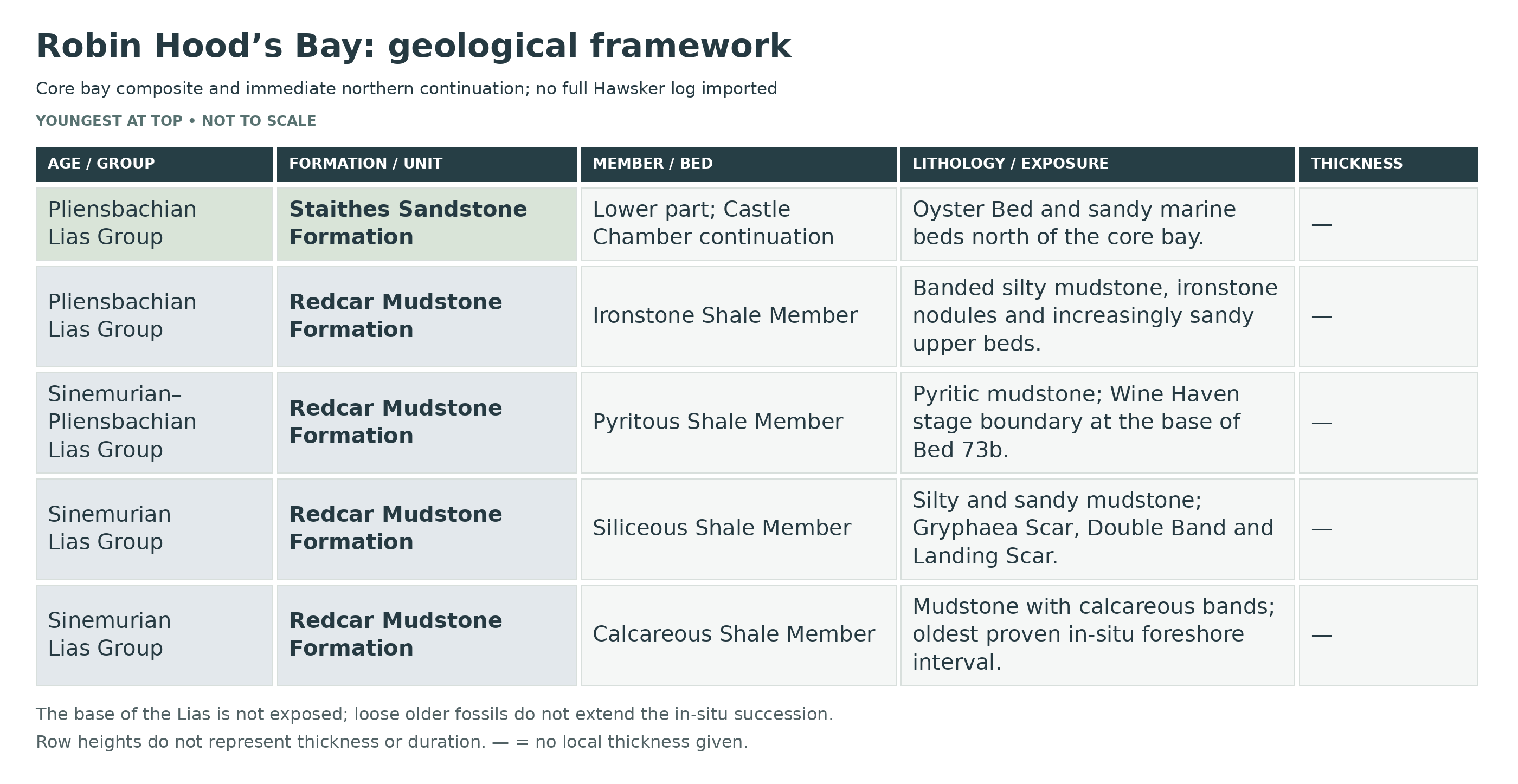
The central Robin Hood’s Bay foreshore is dominated by the Redcar Mudstone Formation, with its four members exposed around a broad dome. The sequence continues northwards into the lower Staithes Sandstone Formation at Castle Chamber. The Cleveland Ironstone and Whitby Mudstone formations belong to the farther continuation towards Hawsker Bottoms and to younger strata across the Peak Fault; they are not additional units stacked above every part of the core bay section.
The lowest exposed rocks belong to the Redcar Mudstone Formation, consisting of dark grey marine mudstones deposited in relatively low-energy offshore settings. These fine sediments accumulated slowly on the seabed and often contain organic material, giving them their characteristic darker colour. Above this, the sequence passes into the Staithes Sandstone Formation, which represents a shift to more energetic, shallow marine conditions. These sandstones and siltstones were deposited under the influence of stronger currents and storms, and sedimentary structures such as ripple marks and cross-bedding can often be observed on the foreshore.
In the farther northward coastal continuation towards Hawsker Bottoms, overlying these units is the Cleveland Ironstone Formation, composed of alternating mudstones and ironstone bands. These ironstone seams formed under specific chemical conditions when iron became concentrated on the seabed during periods of reduced sediment input. The cyclical nature of these deposits reflects repeated environmental changes and they were historically important as part of the Cleveland ironstone mining industry.
Higher in that wider coastal continuation are the darker, more organic-rich shales of the Whitby Mudstone Formation, deposited during the Toarcian Stage. These sediments formed in deeper marine conditions, often under reduced oxygen levels. This formation records significant environmental change, including the Toarcian Oceanic Anoxic Event, when oxygen levels in the oceans declined on a global scale, leading to the preservation of organic-rich sediments.
The broad Robin Hood’s Bay dome brings older strata to the central foreshore. Another major structural feature is the Peak Fault, which runs through the southern side at South Cheek. This fault has displaced the rock sequence, meaning that younger Toarcian shales are found in the south of the bay, while older Pliensbachian strata are more prominent in the north. As a result, rocks of different ages are exposed over relatively short distances, adding to the geological complexity and making Robin Hood’s Bay one of the most informative and important Jurassic sites on the Yorkshire coast.

This is a composite stratigraphic breakdown of Robin Hood’s Bay, where the wave-cut platform of the Robin Hood’s Bay Dome exposes one of Europe’s most complete Sinemurian to lower Pliensbachian successions, including type sections for all four members of the Redcar Mudstone Formation. The south side at Wine Haven contains the internationally ratified GSSP for the base of the Pliensbachian, while the north side of the bay and its immediate continuation carry the sequence upward into the lower Staithes Sandstone Formation at Castle Chamber.
Section Architecture
Robin Hood’s Bay is not a single simple cliff log. The key section is the extensive foreshore cut across the Robin Hood’s Bay Dome, running from Boggle Hole and Wine Haven on the south side of the bay, around Bay Town and North Cheek, and northward into the Castle Chamber continuation. The base of the Lias is not exposed even at the lowest tides, much of the back of the bay is masked by glacial till and landslip, and small faults radiate across the foreshore from the dome structure, so the locality must be treated as a composite wave-cut platform section rather than a single vertical cliff face.
Lowest Exposure Note
The oldest beds proved in situ on the foreshore belong to the upper part of the Semicostatum Zone, Sauzeanum Subzone, within the Calcareous Shale Member. Older Hettangian and lower Sinemurian ammonites are known from beach material and from the district more generally, but they should not be forced into a false in-situ Robin Hood’s Bay cliff log.
Formal Numbering Note
The RHB labels below are practical page headings only. Older GCR composite numbering is retained where stated; the ratified Wine Haven boundary log is explicitly distinguished at RHB17. Formal published bed numbers are retained exactly in each title. The upper Sinemurian and boundary beds mostly follow the Hesselbo & Jenkyns numbering used in the modern GCR summary, whereas parts of the higher lower Pliensbachian north-side section are more commonly cited in the Phelps and Howarth numbering used between North Cheek and Castle Chamber. Where the literature changes numbering system, that change is preserved rather than artificially simplified.
LIAS GROUP
Redcar Mudstone Formation (Lower Jurassic: Hettangian To Pliensbachian; Robin Hood’s Bay Exposures Mainly Upper Sinemurian To Lower Pliensbachian)
The Robin Hood’s Bay dome exposes the classic type sections of the Calcareous Shale, Siliceous Shale, Pyritous Shale and Ironstone Shale members of the Redcar Mudstone Formation. The boundaries between those members are transitional and facies-controlled, so they do not coincide exactly with ammonite-zonal boundaries; this is one of the reasons why the bay has remained so important in British Lower Jurassic correlation.
Calcareous Shale Member
Bed RHB1 — Beds 1–12 (part), Lowest Exposed Calcareous Shales (>11 m)
These are the lowest beds seen in situ on the central and south-eastern foreshore at the very lowest tides. They consist mainly of medium-grey mudstones with several harder silty bands forming reefs in the centre of the bay, together with scattered calcareous lenticles and some nodule bands. Arnioceras is common at several levels, including beds conventionally correlated with the Sauzeanum Subzone, and recorded associates include Arnioceras cf. semicostatum, Euagassiceras and Pararnioceras. The lower part of the member was deposited in a relatively proximal muddy shelf setting influenced by storms, and some of the harder bands and scour-related features show stronger current activity than higher in the member.
Bed RHB2 — Bed 12 (c. 0.30 m Below Top)–14, Brooki Subzone Package (2.5 m)
Mudstones with a harder calcareous band near the middle and another near the top. Caenisites, including C. cf. brooki, is recorded from the upper part of this interval and identifies the Brooki biohorizon. Lithologically these beds remain dominantly muddy, but the indurated bands show repeated brief pauses in sedimentation and early cementation on the sea floor.
Bed RHB3 — Bed 14 (0.97 m Below Top)–21, Birchi Subzone Package (7.11 m)
Medium-grey mudstones with silty bands and some nodule horizons, preserving the typical lower Robin Hood’s Bay shelf facies. Promicroceras capricornoides and Microderoceras birchi are recorded from this package. Fossils are more scattered than in some higher Sinemurian intervals, but the beds remain consistently fossiliferous and preserve the gradual upward passage from the lower Sinemurian into richer upper Sinemurian faunas.
Bed RHB4 — Bed 22, Upper Calcareous Shale Member / Obtusum Subzone (1.71 m)
Mudstone with two bands of calcareous nodules yielding Asteroceras, Promicroceras, Xipheroceras and Cymbites. This bed package marks the top of the Calcareous Shale Member at Robin Hood’s Bay and shows the increasingly fossiliferous and nodule-rich character of the upper Sinemurian. Shell beds within the higher part of the member are commonly dominated by broken but little-worn Gryphaea, suggesting winnowing on a sea floor lying around storm wave-base.
Total Exposed Thickness Of Calcareous Shale Member In The Robin Hood’s Bay Dome Section: More Than 22 Metres, With Older Beds Continuing Offshore Beyond The Lowest Tidal Exposure
Siliceous Shale Member
The Siliceous Shale Member is the most obviously cyclic part of the Robin Hood’s Bay Sinemurian succession. Very fine quartz sand occurs as thin beds, scour fills and muddy sand scars within silty mudstone, producing a series of coarsening-upward cycles that can be followed around both sides of the bay. Benthic faunas are concentrated in the sandier tops of cycles and include Gresslya, Pholadomya and Pleuromya, together with rich trace-fossil assemblages including Teichichnus, Rhizocorallium, Ophiomorpha, Diplocraterion and Chondrites. Some scour floors are sealed by dark clay drapes beneath which articulated asteroids, ophiuroids, echinoids and the crinoid Hispidocrinus scalaris have been preserved, showing episodic rapid burial after reworking.
Bed RHB5 — Bed 23, Basal Siliceous Scar (0.6 m)
A calcareous sandstone forming a prominent scar, with a concretionary band immediately below. This is the first strongly recognisable sandy marker above the Calcareous Shale Member and marks the change into the more obviously cyclic Siliceous Shale facies. It represents a firm, current-worked sea floor developed during a coarser pulse in sediment supply.
Bed RHB6 — Beds 24–26, Gryphaea Scar Package (c. 2.75 m)
Silty mudstone with a nodule band near the middle, capped by the hard calcareous Gryphaea Scar of Bed 26. Promicroceras and Epophioceras occur in the softer beds, while the scar itself is rich in Gryphaea and probably provided the source of some large ex situ Asteroceras of stellare type. This interval records repeated shell accumulation and reworking on a storm-influenced marine shelf.
Beds 24–25 — 2.60 m
Silty mudstone includes a central nodule band and crushed ammonites near the base, including Promicroceras and Epophioceras.
Bed 26 — Gryphaea Scar, 0.15 m
A hard calcareous horizon rich in Gryphaea forms the top of the scar. Asteroceras occurs; large loose specimens may derive from this level.
Bed RHB7 — Beds ?27–33 (Except Topmost c. 0.1 m), Stellare Subzone Package (c. 3.3 m)
Mudstones, silty in part, with scattered lenticles and nodules, overlain by a triple band of siltstone and calcareous concretions, many formed in ammonite body chambers. Asteroceras of the blakei group and Promicroceras are common in the lower part, while Aegasteroceras sagittarium characterizes the upper part. This package contains some of the key stellare-age biohorizon stratotypes for the bay and shows the interplay of muddy background deposition with episodic winnowing and early concretion growth.
Beds ?27–31 — 1.90 m
Partly silty mudstone contains scattered lenticles and nodules, including concretions in ammonite body chambers; Asteroceras of the blakei group and Promicroceras are common.
Beds 32–33, Excluding The Topmost c. 0.1 m — 1.40 m
Mudstone includes a triple band of siltstone and calcareous concretions, often in ammonite body chambers. Aegasteroceras sagittarium occurs in the lower part of Bed 33; this is the sagittarium biohorizon reference interval.
Bed RHB8 — Bed 33 (Topmost c. 0.1 m)–38, Denotatus Subzone Package (c. 4.95 m)
Mudrock with scattered calcareous nodules, lenticles and a distinct denotatus nodule band in Bed 37. Eparietites impendens and allied forms occur low in the package, and Eparietites denotatus is frequent in the nodule band, which is one of the important denotatus biohorizon levels of the bay. This is a richly ammonitic upper Siliceous Shale interval in which the sandy phases are less visually dominant than below, but nodule formation and faunal concentration remain strong.
Bed 33, Topmost c. 0.1 m, To Bed 34, Basal c. 0.15 m — 0.25 m
Nodular mudrock yields Eparietites impendens and Aegasteroceras of the sagittarium group. The GCR notes a small disagreement between published numbering/correlation schemes; the precise partial-bed interval is retained.
Bed 34, Upper Part, To Bed 37, Lower Part — 3.00 m
Mudstone has scattered nodules and lenticles. Aegasteroceras cf. simile occurs at the top of Bed 34 and Eparietites in Bed 36; the interval probably includes the fowleri biohorizon.
Bed 37, c. 1.0–0.5 m Below Its Top — 0.50 m
A calcareous concretion band in mudrock contains frequent Eparietites denotatus and very rare possible Cymbites.
Bed 37, Topmost c. 0.5 m, To Bed 38 — 1.20 m
Mudstone succeeds the denotatus concretion interval. The separately described topmost c. 0.1 m of Bed 38 belongs to the following Simpsoni package.
Bed RHB9 — Bed 38 (Topmost c. 0.1 m)–42, Simpsoni Subzone Package (c. 2.1 m)
A silty seam and nodular mudstone at the base yield Oxynoticeras simpsoni and Gagaticeras of the exortum group; higher up, Bed 41 is a calcareous nodule band with locally abundant Gagaticeras of the gagateum group, and Bed 42 is mudstone with a harder silty band near the top. This is one of the most historically important parts of the whole Robin Hood’s Bay succession because it includes the classic simpsoni and gagateum-type faunas on which much early Sinemurian biostratigraphy was founded.
Bed 38, Topmost c. 0.1 m, To Bed 39 — 0.20 m
A silty seam is overlain by nodular mudstone with common Oxynoticeras simpsoni and Gagaticeras of the exortum group, plus occasional Palaeoechioceras aff. pierrei.
Bed 41 — 0.10 m
Calcareous nodules locally contain abundant Gagaticeras of the gagateum group and occasional Oxynoticeras simpsoni.
Bed 42 — 1.80 m
Mudstone has a thin harder silty bed near the top. The source records Oxynoticeras oxynotum 0.86 m above its base. No separate description of Bed 40 is invented where this published synthesis does not provide one.
Bed RHB10 — Bed 43, Double Band (0.4 m)
The famous Double Band is a conspicuous bipartite bed of bioturbated fine sandstone, best seen on the north side of Boggle Hole at the base of a small promontory. It is one of the most useful field markers in the entire bay. Rich trace fossils include Diplocraterion, Teichichnus, Ophiomorpha and Chondrites. The bed marks a short-lived influx of sand and benthic colonization in otherwise mud-dominated shelf sedimentation.
Bed RHB11 — Beds 44–53 (lower part), Upper Oxynotum Package (c. 7.5 m)
Above the Double Band lies a thicker upper Oxynotum package of mudstones with calcareous concretions, resistant silty bands and a major silty sandstone pair represented by Bed 51. Large Oxynoticeras of the oxynotum group occur in the lower part, with rarer Bifericeras bifer and related forms, while Bed 44 may represent the oxynotum biohorizon itself. These beds show repeated alternation between quieter mud accumulation and stronger event deposition, still on a shallow offshore shelf.
Bed 44 — 1.60 m
Mudstone has a lower calcareous nodule band rich in small bivalves, with Oxynoticeras of the oxynotum group and possible Cenoceras.
Beds 45–47 — 2.10 m
Mudstone contains resistant silty bands and lenticles; Bifericeras occurs about 0.20 m above the base.
Beds ?48–?49 — 1.30 m
Scar-forming silty sandstone is followed by mudstone. Large Oxynoticeras of the oxynotum group and rare Bifericeras bifer occur near the top of ?48 and in ?49.
Beds 50–53, Lower Part — 2.50 m
Mudstone includes nodules and lenticles and the prominent double calcareous silty sandstone of Bed 51, about 0.40 m thick. The upper band of Bed 53 remains with the next Densinodulum interval.
Bed RHB12 — Beds 53 (upper band)–55, Densinodulum Subzone Package (1.2 m)
A thin but important sandy and nodular package. The upper band of Bed 53 is a silty calcareous bed with small nodules yielding Crucilobiceras densinodulum, overlain by mudstone and then a second thin sandy bed. This interval probably includes the lymense biohorizon and marks the first clearly recognised densinodulum fauna in the bay.
Bed RHB13 — Beds 56–60, Raricostatum Subzone Package (Combined Thickness Unassigned)
Mudrock with a thin sandy siltstone band above, followed by silty mudstone with abundant crushed Echioceras of the raricostatum group and capped by Bed 60, a nodule-bearing mudstone yielding Echioceras cf. intermedium and Eoderoceras. This subzone is especially notable because crushed ammonites become relatively abundant in the shales themselves, not just in discrete nodules.
Beds 56–57 — 0.90 m
Mudrock passes up into thin sandy siltstone; juvenile Echioceras occurs in Bed 56.
Bed 58
Partly silty mudstone contains abundant Echioceras of the raricostatum group, mainly flattened in shale. The printed synthesis does not give a separate thickness here.
Bed 59 — 0.20 m
Calcareous sandstone separates the muddy fossil-bearing intervals.
Bed 60 — 0.60 m
Mudstone contains carbonate lenticles and nodules with Echioceras cf. intermedium and Eoderoceras.
Bed RHB14 — Beds 61–67, Macdonnelli Subzone Package (c. 6.4 m)
Silty mudstones with ferruginous and calcareous lenticles and nodules, including the prominent East Scar of Bed 63. Leptechioceras of the planum and macdonnelli groups, together with Eoderoceras and Radstockiceras, identify the macdonnelli fauna. The member remains distinctly sandy and cyclic here, but the ammonite assemblage changes decisively from oxynotid-dominated faunas below into echioceratid and eoderoceratid assemblages characteristic of the highest Sinemurian.
Beds 61–62 — 1.90 m
Partly silty mudstone contains iron-rich calcareous lenticles. Leptechioceras planum in Bed 61 supports the meigeni/planum biohorizon correlation.
Bed 63 — East Scar, 0.70 m
Siltstone passes into silty sandstone with a bioturbated top, forming East Scar.
Bed 64, Lower Part — 1.00 m
Mudstone forms the lower part of the succeeding cycle and is assigned provisionally to the Macdonnelli Subzone.
Bed 64, Upper c. 0.8 m?, To Bed 67 — 2.80 m
Mudstone with silty horizons contains ferruginous and calcareous nodules and lenticles; fossils include Leptechioceras macdonnelli, the L. meigeni group, Eoderoceras and Radstockiceras.
Bed RHB15 — Bed 68, Landing Scar (0.8 m)
A silty sandstone, bioturbated in its upper part, forming Landing Scar at Bay Town. Leptechioceras of the meigeni group are recorded from this bed. It is one of the clearest practical field datums in the bay and marks the top of the obviously sandy Siliceous Shale facies before the darker boundary mudstones above.
Total Thickness Of The Siliceous Shale Member In The Robin Hood’s Bay Composite Section: Approximately 34 Metres
Pyritous Shale Member
The Pyritous Shale Member comprises dark grey to black pyritic mudstones spanning the uppermost Sinemurian and lowest Pliensbachian boundary interval. It is much darker and less overtly sandy than the member below, although scour fills occur near its base and top. Benthic fossils are relatively sparse, bioturbation is mainly pyritized Chondrites with subordinate Rhizocorallium, Ophiomorpha and Teichichnus, and the whole facies records a relative deepening and more dysaerobic sea floor.
Bed RHB16 — Beds 69–70, Aureolum–Aplanatum Boundary Package (c. 2.4 m)
Grey to dark-grey mudstones with a siltstone horizon and nodule bands, capped by a red-weathering nodular horizon. Paltechioceras aureolum occurs in the lower part, while the top carries Paltechioceras aplanatum, Eoderoceras and probable Gleviceras. These beds include the aureolum and aplanatum biohorizon stratotypes and form the immediate pre-boundary uppermost Sinemurian sequence at Wine Haven.
Bed 69, Main Lower Part — 2.20 m In The Older GCR Log
Mudstone contains a siltstone horizon and basal nodules; Paltechioceras aureolum occurs from at least 0.20 m above the base. This is the aureolum biohorizon reference interval.
Bed 69, Topmost c. 0.15 m, To ?Bed 70 — 0.20 m
Grey mudstone includes a red-weathering nodular horizon above an intermittent greyer nodule band, with Paltechioceras aplanatum, Eoderoceras and possible Gleviceras. The uncertain upper bed assignment is retained.
Bed RHB17 — Donovani Boundary Interval: Older GCR Bed 71 And Ratified Wine Haven Bed 73b
The older GCR synthesis describes the proposed boundary interval under Bed 71, comprising mudstone and a thin fossil-rich interval with small, commonly pyritised Bifericeras donovani, rare juvenile Apoderoceras and Gleviceras. This older log notation must not be mistaken for the ratified GSSP bed number. The international definition published by Meister and colleagues in 2006 and maintained by the International Commission on Stratigraphy places the base of the Pliensbachian at the base of Bed 73b in the Wine Haven boundary log, 6 cm above the mid-line of the Bed 72 nodules. The defining association is Bifericeras donovani with Apoderoceras. The surrounding rocks pass from pale-grey and buff sandy mudstone into dark-grey silty shale. The 2.3 m grouped interval in the older summary is not a thickness for Bed 73b.
Bed 71, Lower Part — 1.70 m In The Older GCR Log
Mudstone is assigned to the upper Sinemurian Aplanatum interval in the older synthesis.
Bed 71, Donovani Interval — 0.20 m In The Older GCR Log
Small fossils, commonly pyritised, include Bifericeras donovani, with rarer Apoderoceras and Gleviceras. The interval lies approximately 0.60–0.40 m below the top of the older Bed 71.
Bed 71, Uppermost Part — 0.40 m In The Older GCR Log
Mudstone above the thin donovani interval completes the older grouped Bed 71. These historical subdivisions are not substituted for the ratified Wine Haven Bed 73b definition above.
Bed RHB18 — Beds 72–101 Of The Older GCR Composite, Pyritous Shales Proper (21 m)
Dark mudrocks with bands of ferruginous nodules and concretions forming the main body of the Pyritous Shale Member. Large Apoderoceras occur at least in the lower part, and Phricodoceras is also recorded. Thin-shelled benthos occurs chiefly near the base and top of the member, but otherwise the facies is relatively low-diversity and pyrite-rich. This interval records the continuation of relatively deep, stressed shelf deposition after the stage boundary, before the more obviously banded lower Ironstone Shale facies develops above.
Total Thickness Of The Pyritous Shale Member At Robin Hood’s Bay: About 26 Metres Including The Boundary Package
Ironstone Shale Member
Member Note
The lower Ironstone Shale Member is exceptionally well exposed on the north side of Robin Hood’s Bay between Bay Town and Castle Chamber. It comprises alternating dark and pale silty mudstones, ferruginous nodule bands, sideritic concretions and locally sandy units. The lower part, especially across the Polymorphus, Brevispina and Jamesoni subzones, forms the classic “Banded Shales”, in which the paler beds are coarser grained, more carbonate-rich and benthos-rich, while the darker beds are more organic and finer grained. From around the Ibex Zone upward, large Pinna become a conspicuous feature, locally in life position and elsewhere current-sorted parallel to bedding. Because published numbering changes within this member, both numbering systems are retained exactly below.
Bed RHB19 — Beds 102–106, Upper Taylori Transition Beds
Mudstones with bands of calcareous nodules forming the transition from the dark Pyritous Shale Member into the lower Ironstone Shale facies. Although less fossiliferous in published summaries than the beds above, these beds are important because they show that the lithological shift at the base of the Ironstone Shale Member is gradual rather than abrupt.
Bed RHB20 — Beds 107–?113 (part), Polymorphus Subzone Banded Shales (c. 9.5 m)
Alternating dark and pale mudstones, in part silty, with ferruginous nodules and concretions. Polymorphites is the characteristic ammonite, and the facies is the classic lower “Banded Shales” expression of the Ironstone Shale Member. The alternation of paler, coarser, more benthos-rich beds with darker, finer, more organic beds is especially clear in this part of the member and has been central to discussion of climatic cyclicity and shallow-marine shelf sedimentation in the Cleveland Basin.
The 9.5 m estimate follows Hesselbo and Jenkyns’s Ironstone Shale-facies interpretation. Bairstow’s records, quoted in Cope and colleagues, give about 6 m and include some Pyritous Shale facies. These are different published estimates, not interchangeable local measurements.
Bed RHB21 — Beds ?113 (?part)–?116 (?part), Brevispina Subzone Banded Shales (c. 3.5 m)
Dark-and-pale mudstone alternations with ferruginous nodules and concretions, yielding Platypleuroceras, including P. brevispina, and allied polymorphitids. Lithologically similar to the beds below, these strata continue the banded shallow-shelf rhythm but with a distinct ammonite fauna and slightly more persistent concretion horizons.
Hesselbo and Jenkyns estimate about 3.5 m for this subzone; Bairstow’s records quoted in Cope and colleagues indicate about 6 m. The uncertain bed limits and disagreement are retained.
Bed RHB22 — Beds ?117 (?part)–121 (part), Jamesoni Subzone Banded Shales (c. 7 m)
Mudstone alternations, dark and pale, in part silty, with ferruginous nodules. Published faunal records are less complete here than in some other subzones, but Uptonia jamesoni and Lytoceras occur in the upper part. These beds complete the Jamesoni-Zone banded shale development and are important because they bridge the transition into the higher, more fossil-rich Ibex-Zone part of the north-side section.
The approximately 7 m estimate follows Hesselbo and Jenkyns. Bairstow’s records quoted in Cope and colleagues give about 3.5 m. Faunal records are incomplete; the GCR securely notes Uptonia jamesoni and Lytoceras in the upper 1.5 m.
Bed RHB23 — Bed 121 (part) And Beds 1–4, Arietiforme To Valdani Interval (Combined Thickness Unassigned)
The published numbering changes at this level. The basal part includes dark-and-pale mudstone alternations with ferruginous lenticles, followed by ferruginous nodule bands and alternating dark and pale silty mudstones. Recorded faunas include Cymbites in the lower part, Liparoceras cheltiense in Beds 2–3, and Acanthopleuroceras lepidum in Bed 4b, with Acanthopleuroceras maugenesti in the ferruginous nodule band at Bed 1. This is the incoming of classic Ibex-Zone liparoceratid–acanthopleuroceratid faunas on the north side of the bay.
Bed 121, Part — 1.10 m
Alternating dark and pale mudstone with ferruginous lenticles yields Cymbites. This is the Hesselbo–Jenkyns interval identified as 0 or 200 in Phelps’s scheme.
Restarted Bed 1 — 0.10 m
A ferruginous nodule band yields Acanthopleuroceras maugenesti. The numbering restart is retained explicitly.
Restarted Beds 2–3 — Thickness Unassigned In The GCR Table
Alternating dark and pale, partly silty mudstones have a ferruginous nodule band and Liparoceras cheltiense. No individual thickness is inferred by subtracting other values from the grouped estimate.
Restarted Bed 4 — 1.70 m
Dark and pale mudstone alternations are partly silty; Acanthopleuroceras lepidum occurs in subdivision 4b.
Bed RHB24 — Beds 5–18, Rotundum To Luridum Interval (c. 20.1 m)
Mainly dark mudstones with ferruginous nodule bands below, passing upward into darker silty mudstones and concretion-rich beds of Luridum age. Characteristic ammonites include Beaniceras crassum, B. luridum, Liparoceras heptangulare, L. naptonense and Lytoceras. From about this level upward through much of the Ibex Zone, large Pinna become conspicuous and may be seen either in life position or current-sorted parallel to bedding, giving one of the most distinctive faunal signatures of the Robin Hood’s Bay lower Pliensbachian. The beds record shallow-marine mud sedimentation with strong current influence, episodic storm reworking and repeated siderite growth.
Beds 5–6 — 2.00 m
Dark mudstone has a ferruginous concretion band with Lytoceras and Tragophylloceras; the Rotundum assignment is queried in the source.
Beds 7–14 — 10.80 m
Mostly dark mudstone with iron-rich nodules yields Beaniceras crassum, transitional forms in Bed 7, Liparoceras and Lytoceras.
Beds 15–18 — 7.30 m
Dark, partly silty mudstone with ferruginous nodules contains Beaniceras luridum, its geyeri variety, Liparoceras and Lytoceras fimbriatum.
Bed RHB25 — Beds 19–35, Sparsicosta Interval (15.5 m)
Darker grey mudstones below, generally becoming more silty upward and including a sandy unit toward the middle, with calcareous ferruginous nodules and one especially important oolitic ironstone level. The fauna of Beds 21–29 includes Aegoceras maculatum var. atavum, Androgynoceras heterogenes, A. sparsicosta, Liparoceras heptangulare, L. naptonense, Pagophylloceras and Lytoceras. Bed 21 is particularly significant: it is a nodular oolitic ironstone with large subvertical burrows filled with chamositic ooliths and represents the lowest Jurassic level in the Cleveland Basin where true oolitic ironstone is developed. Higher in the interval, shell-rich beds, woody debris and continuing Pinna levels indicate increasingly active, shallow, current-swept shelf conditions.
Bed RHB26 — Beds 36–40, Maculatum Interval (2.7 m)
Silty mudstone with ferruginous nodule bands yielding Androgynoceras maculatum and its heterogenes–leckenbyi variants. This is the uppermost Ironstone Shale Member interval included in the core Robin Hood’s Bay lower Pliensbachian succession. The beds are comparatively finer than some of the coarser Ibex-Zone intervals below, but the facies remains shallow marine and transitional upward toward the basal sandy Staithes Sandstone sea-floor.
Staithes Sandstone Formation (Pliensbachian)
Formation Note
Only the lower part of the Staithes Sandstone Formation is included here, where it comes down to shore level at Castle Chamber and the immediate northward continuation. The formation is dominated by bioturbated siltstones and fine sandstones with small-scale coarsening- and fining-upward cycles, wave ripples, gutter casts and shell-rich horizons. The base is taken at the distinctive ferruginous shelly Oyster Bed.
Bed RHB27 — Bed 41, Oyster Bed (0.2 m)
A ferruginous concretionary shell band forming the base of the Staithes Sandstone Formation in the Castle Chamber continuation. Aegoceras ?capricornus is recorded. This thin but distinctive bed is one of the sharpest practical lithological markers in the whole Robin Hood’s Bay lower Pliensbachian succession.
Bed RHB28 — Beds 42–45, Capricornus Beds (1.3 m)
Siltstones with a band of ferruginous nodules and concretions, carrying Aegoceras capricornus, A. lataecosta and allied forms. These beds are already much sandier and more bioturbated than the Ironstone Shale Member below, reflecting the arrival of a shallower and more energetic shelf regime.
Bed RHB29 — Beds 46–48, Crescens Interval (c. 1.6 m)
Siltstone with ferruginous concretions, including a basal nodule band. Aegoceras crescens occurs, including forms transitional upward toward Oistoceras angulatum. This is a classic transitional shallow-water ammonite-bearing interval in the lower Staithes Sandstone.
Bed RHB30 — Beds 49–58, Angulatum Interval (c. 6.4 m)
Siltstone with concretionary bands in the upper part and mudstone with ferruginous concretions near the base, yielding Oistoceras angulatum, related transitional forms and Liparoceras divaricosta. The facies is heavily bioturbated in places, but hummocky cross-bedding, wave ripples and minor scour gutters show that these were storm-agitated shallow-marine sands and silts rather than quiet offshore muds.
Bed RHB31 — Beds 59–61, Castle Chamber Floor Sandstone (c. 2.15 m)
Hard ferruginous sandstone forming the floor of Castle Chamber. Oistoceras angulatum is characteristic. The bed has long been one of the key field markers at Castle Chamber because it forms the shelter floor and clearly displays the more arenaceous style of the Staithes Sandstone Formation. Scour at the base indicates energetic erosion before deposition of the sandstone body.
Bed RHB32 — Beds 62–65, Figulinum Interval (0.45 m)
Two bands of red calcareous concretions separated by sandy shale and siltstone, yielding Oistoceras figulinum, O. curvicorne and forms transitional toward later Amaltheus. This is the highest lower Pliensbachian interval included in the core Robin Hood’s Bay page and forms the top of the lower Staithes section before the overlying upper Pliensbachian Amaltheus-bearing sands of the Hawsker continuation.
Higher Continuation Note
Immediately above the lower Staithes beds logged here, the Castle Chamber roof sandstones and the first Amaltheus mark the onset of the upper Pliensbachian Hawsker Bottoms succession. Those younger Stokesi-, Margaritatus- and Toarcian beds are best treated as the Castle Chamber–Hawsker continuation and are not forced into this Robin Hood’s Bay page.
Depositional Environment
The Robin Hood’s Bay succession records repeated shifts across a shallow but fully marine Jurassic shelf on the margin of the Cleveland Basin. The Calcareous Shale Member represents relatively proximal muddy shelf sedimentation with silty storm-influenced beds and local shell concentrations. The Siliceous Shale Member records stronger rhythmic alternation between mud and very fine sand, with scour hollows, sandy foreshore scars, abundant trace fossils and periodic winnowing around storm wave-base. The Pyritous Shale Member marks a relative deepening and more dysaerobic sea floor across the latest Sinemurian to earliest Pliensbachian interval, culminating in the internationally important donovani horizon and the Pliensbachian GSSP at Wine Haven. The Ironstone Shale Member records a return to more strongly cyclical, banded shallow-marine mudstone and siltstone deposition with ferruginous nodules, early oolitic ironstone, large Pinna communities and increasing upward coarsening. The lower Staithes Sandstone Formation completes the section with bioturbated storm-worked silts and fine sands deposited in a shallower, higher-energy shelf setting.
Composite Thickness: Individually Scoped Intervals, Without An Unverified Grand Total
References
Howarth, M.K. (2002). The Lower Lias of Robin Hood’s Bay, Yorkshire, and the work of Leslie Bairstow.
Hesselbo, S.P. & Jenkyns, H.C. (1995). Detailed stratigraphy and sequence stratigraphy of the Hettangian to mid-Pliensbachian Robin Hood’s Bay succession.
Dommergues, J.-L. & Meister, C. (1992) on the Sinemurian–Pliensbachian ammonite succession and the Bifericeras donovani horizon at Wine Haven.
Meister, C. and co-authors (2006). The Global Boundary Stratotype Section and Point (GSSP) for the base of the Pliensbachian Stage, Wine Haven, Robin Hood’s Bay.
Howarth, M.K. (1955, 1973, 1992) on the Pliensbachian and Toarcian ammonite succession of the Yorkshire coast.
Howard, A.S. (1985). Lithostratigraphy of the Staithes Sandstone and Cleveland Ironstone formations of north-east Yorkshire.
Phelps, M. (1985) on the Castle Chamber and lower Staithes Sandstone succession.
Page, K.N. (1992, 1995) on Lower Jurassic biohorizons and Robin Hood’s Bay stratotypes.
British Geological Survey Lexicon: Redcar Mudstone Formation, Calcareous Shale Member, Siliceous Shale Member, Pyritous Shale Member, Ironstone Shale Member and Staithes Sandstone Formation.
Geological Conservation Review accounts: Normanby Stye Batts–Miller’s Nab (Robin Hood’s Bay), North Yorkshire, and Castlechamber to Maw Wyke, North Yorkshire.
SAFETY
Common sense when collecting at all locations should be used and knowledge of tide times is essential. This part of the coastline is very dangerous as a result of tidal conditions, so make sure you return before the tide turns. Keep away from the base of the cliffs, as rock falls are very common. Hard hats are recommended.
EQUIPMENT
At Robin Hood’s Bay, fossil collecting often requires more effort than at other Yorkshire localities, so the right equipment is particularly important. A geological hammer and flat chisel may be useful for permitted loose nodules or fallen blocks on the open foreshore. Do not hammer the in-situ reefs or cliffs; use a hand lens and photographs to study fossils still in bedrock. Eye protection should always be worn when splitting rock, and strong, waterproof boots with good grip are essential, as the wave-cut platforms can be extremely slippery and uneven, especially at low tide. Because access to the reefs depends on tide times, always check tide tables before setting out to avoid being cut off. Any fossils collected should be wrapped securely in protective material and placed in a rigid container or rucksack to prevent damage during transport.
CLEANING AND TREATING
Begin by removing any loose sediment very carefully using a soft toothbrush. Take your time, as many fossils—particularly pyritic specimens—are fragile and easily damaged. Keep delicate shale and pyritic fossils supported in their matrix, and assess whether the specimen can tolerate water before any wet cleaning. Do not apply a fixed soaking time to every fossil. After any appropriate wet cleaning, allow specimens to dry naturally at room temperature. Do not dry them on radiators or other heat sources, as rapid drying can cause cracking or long-term damage.
Use Paraloid B-72 selectively where consolidation is needed, after assessing the fossil and matrix. It can be re-dissolved, although complete removal from a porous specimen may not be possible. Coating is not a substitute for dry, monitored storage of pyritic fossils and does not cure pyrite decay.
Avoid routine artists’ varnish or cosmetic coatings, even on common ammonites. Preserve the original surface and record any treatment; for fragile or potentially important finds, seek preparation or conservation advice before further work.
IDENTIFY YOUR FINDS
Need help identifying a fossil? Share clear photos, where you found it and its size with the community.
FURTHER READING
Deposits – The Rotunda Museum, Scarborough
Yorkshire Geological Society – Robin Hood’s Bay to Hawsker Bottoms
Whitby Museum – Geology and Fossils
British Geological Survey – Cleveland Ironstone Formation
ACCESS RIGHTS
This site is a site of special scientific interest (SSSI). This means you can visit the site, but hammering the bedrock is not permitted. For full information about the reasons for the status of the site and restrictions, download the PDF from Natural England
It is important to follow our ‘Code of Conduct’ when collecting fossils or visiting any site. Please also read our ‘Terms and Conditions‘
LINKS
♦ Fossil Discussions
♦ Fossil Articles
♦ Buy Fossils, Tools and Equipment
♦ Buy Crystals, Meteorites, and Artefacts
♦ Join Fossil Hunts
♦ UK Fossils Network