Ringstead Bay is a wonderful location, with rocks and fossils from the Corallian, Kimmeridge Clay, Purbeck Beds and Portland Beds to be found. The site consists mostly of Kimmeridge Clay from the Upper Jurassic. It is rich in fossils and with easy parking, toilets and refreshments nearby; it’s an ideal, safe location for the family. The site is productive in either direction from the access point. This location is also just a short walk away from other good sites and makes for an ideal day trip.


FIND FREQUENCY: ♦♦♦♦ – Fossils at Ringstead Bay are common. The giant oysters (Deltoideum delta) are found in the cliffs and foreshore. Other fossils also occur but the site is certainly more productive during scouring conditions in the winter months.
CHILDREN: ♦♦♦♦ – An excellent site for children. They can usually pick up various fossils along the coast and the beautiful location also makes a wonderful family walk.
ACCESS: ♦♦♦♦♦ – Access is very easy with parking at the car park. From the car park, walk towards the beach, bearing right and then descend to the beach, by way of a concrete slipway. . Turn left (east) for the high Kimmeridge Clay cliffs and fossils from this formation and from the Purbeck and Portland Formations. Turn right (west) for the low Kimmeridge Clay cliffs and Corallian rocks. However, the best time to visit is after winter storms.
TYPE: Look for loose fossils on the open foreshore, well clear of the cliffs, fresh falls and soft mud. Do not prise fossils from the cliff base.
DIRECTIONS
♦ Ringstead Bay and car park can be accessed by taking the A353 out of Weymouth, through Osmington village and turning right (signposted Ringstead Bay & Beach Cafe) before Poxwell village. Wind down the narrow lane until the road forks. Bear right onto the old toll road and descend to the coast
♦ There is a daily rate charge at the car park (April to November) and the beach café/shop is open during the summer season, with toilets close by.
♦ What3Words: ///emulating.jigging.nicknames
♦ Postcode: DT2 8NG, Google Maps Link.
VIDEO FILM
FOSSIL HUNTING
Westwards towards Bran Point, the uppermost Corallian Group includes the Ringstead Clay Member and the overlying Osmington Mills Ironstone Member of the Sandsfoot Formation. The Ringstead Coral Bed is a local coral-bearing facies of the latter member, not an old name for the whole formation. Above it, the Inconstans Bed marks the base of the Kimmeridge Clay Formation and contains the distinctive asymmetrical brachiopod Torquirhynchia inconstans. Large shells of the oyster Deltoideum delta occur in the succeeding clay succession.
At this location, the Corallian consists of brown and dark green sandy clay, often with rich oolitic ironstone present. Occasionally, isolated corals can be found but in the main, colonial corals form part of a thin but distinguishable layer of limestone, protruding from the low cliffs at beach level. The layer comprises corals, bivalves and other fauna often found in broken rocks beneath the low, slumped cliffs at this section. Recorded corals include Thecosmilia annularis, a branching coral that may be found as isolated pieces, together with Thamnasteria and Protoseris.
On the foreshore and as off-shore reefs, especially at low tide, can be seen the prominent Corallian rocks of the Osmington Oolite Formation and Clavellata Formation, consisting of the worn surfaces of thousands of thick shells within an incredibly hard limestone. This rock extends out into the sea as a wave-cut platform with distinct reefs. The shells mostly belong to the large marine bivalve, Myophorella clavellata are very common in Corallian rocks between Ringstead and Weymouth. These shells are very difficult to extract and collection should be left to isolated specimens and single, wave-worn specimens, which often turn up on the beach.
Walking left (east) from the access point, along the shingle beach towards White Nothe, past the small caravan site and rock armour, the tall cliffs of slumped, badly weathered Kimmeridge Clay forms the majority of the rock type found. The cliffs at the eastern end of the bay are known as Burning Cliff, due to a spontaneous combustion of the organic-rich bituminous oil shales within the clay. The fires burned from 1826 to 1830 but there has been no recent occurrence!
The Late Jurassic Kimmeridge Clay here is fossiliferous with ammonites (Pictonia densicostata, Rasenia cymodoce, Aulacostephanus sp., Amoeboceras (Nannocardioceras) sp.), bivalves (e.g. Lopha gregarea) and gastropods (including Bathrotomaria reticulata and Bourgetia). These are often quite fragile. Worm tubes (Cycloserpula intestinalis) are common finds. Large bivalves, Ctenostreon proboscideum, embedded in the rocks as partial specimens, are also frequently found. Marine reptile remains are rare but do occur.
High in the cliffs, east of Burning Cliff and west of Holworth House (and also frequently seen as slipped masses at beach level), are the strata of the Portland Stone Formation and the basal part of the Lulworth Formation of the Purbeck Group.
The rocks here are folded and faulted, forming a spectacular unconformity, with the Chalk dipping to the right and the Portland and Purbeck Beds dipping to the left. Loose rocks on the beach may contain fossil shells; examine only permitted loose material on firm, open foreshore, well clear of cliff bases, fresh falls and slipped ground.


Some of the most significant fossil discoveries and scientific milestones from Ringstead Bay include the classic Ringstead Coral Bed, early work on the Oxfordian–Kimmeridgian boundary, the long use of the section as the recommended basal boundary stratotype for the Kimmeridgian Stage, and notable later fossil finds from the bay.
1865 – the Oxfordian–Kimmeridgian boundary at Ringstead was already being recorded in the literature
The junction between the Ringstead Coral Bed and the overlying Kimmeridge Clay at Ringstead was recorded in nineteenth-century work, making the bay one of the classic Dorset localities for the base of the Kimmeridgian succession.
1877 – Blake and Hudleston further documented the Ringstead boundary beds
Later nineteenth-century work refined knowledge of the Ringstead succession and helped establish the importance of the bay for the uppermost Corallian and lowermost Kimmeridge Clay beds.
1914 – Salfeld recorded the boundary beds and ammonite succession at Ringstead
Early twentieth-century work continued to build the case for Ringstead as one of the most important localities for understanding the Oxfordian–Kimmeridgian transition in southern England.
1933–1936 – W. J. Arkell published his classic work on the Ringstead Corallian succession
Arkell’s studies of the Corallian beds between Osmington and Ringstead became the classic reference for the area. His bed-by-bed work helped fix the importance of Ringstead for corals, oysters, ammonites and other Upper Jurassic fossils.
1947 – Arkell’s later synthesis cemented Ringstead as a classic Upper Jurassic Dorset locality
Arkell’s later publications kept Ringstead central to discussions of Dorset Upper Jurassic stratigraphy and fossil faunas, especially the richly fossiliferous upper Corallian beds below the Kimmeridge Clay.
1969 – Ringstead was recommended as the basal boundary stratotype for the Kimmeridgian Stage
For many years, the basal beds at Ringstead Bay were the recommended boundary stratotype for the base of the Kimmeridgian Stage. This made the site internationally important, not just as a fossil locality, but as a reference point in Jurassic stratigraphy.
1978–1981 – the Ringstead boundary beds were revised in detail
Later twentieth-century work by Brookfield and by Cox and Gallois refined the lithostratigraphy and faunas of the upper Oxfordian and lower Kimmeridgian beds at Ringstead. This improved understanding of the Inconstans Bed and the faunal changes across the stage boundary.
1986 – the Ringstead Coral Bed was highlighted as a distinctive coral-rich Upper Jurassic bed
Modern work showed that the Ringstead Coral Bed, with masses of Thamnasteria arachnoides, remained one of the most distinctive fossil horizons in the bay. It is unusual in south Dorset because it is the only Corallian bed there to contain abundant corals.
1994 – Ringstead was still being treated as the recommended boundary stratotype for the base of the Kimmeridgian
Detailed studies of the Oxfordian–Kimmeridgian boundary beds continued to use Ringstead as the recommended basal boundary stratotype for the Kimmeridgian Stage, confirming the long-standing importance of the bay in international Jurassic correlation.
1996 – a rare giant chalk ammonite was found at Ringstead Bay
A fine specimen of the rare chalk ammonite Parapuzosia leptophylla, about 3 feet in diameter, was found at Ringstead Bay by two members of the Bournemouth Natural Science Society. It is one of the more notable individual fossil finds reported from the locality.
Late 1990s–2000s – Ringstead remained central to debate over the Kimmeridgian boundary
Although later work favoured other sections for the eventual formal global boundary, Ringstead continued to be recognised as one of the classic Dorset reference localities for the base of the Kimmeridgian and the transition from the Corallian into the Kimmeridge Clay.
2021 – the formal global boundary for the base of the Kimmeridgian was fixed elsewhere, but Ringstead retained its historic importance
The formal global reference point for the base of the Kimmeridgian was ratified at Flodigarry on the Isle of Skye in 2021. Ringstead had been an important earlier candidate and recommended reference section; it was never the ratified global GSSP. Its boundary beds remain important for the history and correlation of the Dorset succession.
GEOLOGY
The geology of Ringstead Bay records a long and complex history of changing Jurassic environments, preserved in a succession of sedimentary rocks that span several million years. Much of the bay is dominated by Kimmeridge Clay, a dark, fine-grained mudstone deposited in a relatively deep, low-energy marine setting during the Late Jurassic. These sediments accumulated offshore under oxygen-poor conditions, allowing large quantities of organic material to be preserved within the clay. Today, the Kimmeridge Clay forms steep, heavily weathered cliffs that are prone to landslip and erosion, giving rise to the slumped profiles and frequent rock falls that characterise much of the eastern side of the bay.
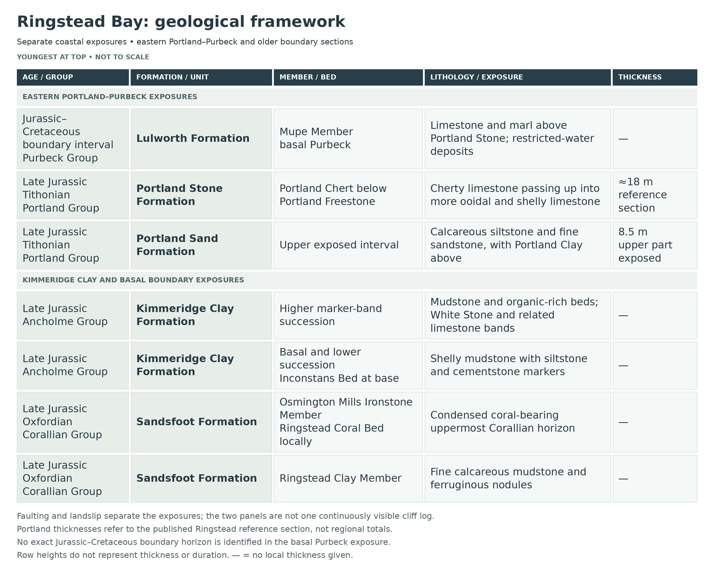
In the eastern part of the bay, the faulted and landslipped succession includes the Portland Sand and Portland Stone formations above the Kimmeridge Clay. The Portland Stone contains the Portland Chert and Portland Freestone members, recording shallower-water carbonate deposition. The overlying basal Lulworth Formation of the Purbeck Group includes the Mupe Member, with limestone and marl formed in more restricted environments. These separate eastern exposures should not be confused with the older Corallian–Kimmeridge boundary sections elsewhere in the bay.
The western bay exposes older Corallian rocks. In upward order, the regional succession passes from the Osmington Oolite Formation into the shell-rich Clavellata Formation, and then into the younger Sandsfoot Formation. Around Ringstead the upper Sandsfoot is represented by quiet-water Ringstead Clay and the condensed coral-bearing Osmington Mills Ironstone Member beneath the Kimmeridge Clay. This records changing shallow-marine conditions, with restricted muddy intervals interrupted by renewed marine colonisation. The coral bed is a thin horizon within that succession, rather than an extensive reef or the whole Sandsfoot Formation.

Ringstead Bay is a composite Upper Jurassic section in which the uppermost Corallian Ringstead Clay and Ringstead Coral Bed pass into the basal Kimmeridge Clay boundary beds, while higher, landslipped and faulted exposures farther east preserve higher Kimmeridge Clay marker bands beneath the Portland Group. It is one of the classic Dorset localities for the Oxfordian–Kimmeridgian transition, for the Inconstans and Nana beds at the base of the Kimmeridge Clay, and for correlation of named Kimmeridge marker beds across the type area.
This account retains separate western boundary, eastern Kimmeridge and faulted Holworth House Portland–Purbeck sections. Traditional British “Upper Kimmeridgian” terminology in older sources is not treated as identical to the modern international stage: the higher Kimmeridge Clay and Portland succession extends into the Tithonian. RB labels are editorial identifiers; Arkell numbers and source question marks remain explicit.
CORALLIAN GROUP
Sandsfoot Formation (Upper Oxfordian)
Oxfordian Section Character At Ringstead Bay
At Ringstead Bay the uppermost Sandsfoot Formation is exposed in low, landslipped clifflets and foreshore embayments rather than in a single clean wall. The type Ringstead Clay Member and Bed 25 are the key Oxfordian units here; the underlying Sandsfoot Grit is attenuated and is much better exposed westwards toward Black Head and Osmington Mills, so it is not forced into a false bed-by-bed Ringstead log below.
Ringstead Clay Member
Bed RB1 — Lower Ringstead Clay (Arkell Beds 24a–24b; up to c. 1.0 m visible at the type locality)
At Ringstead Bay, favourable foreshore conditions expose pale grey, very fine-grained, variably calcareous mudstone with numerous fine carbonate laminae that are little affected by bioturbation. This lower part of the old Ringstead Waxy Clay includes Arkell’s Beds 24a–24b and records quiet, restricted mud accumulation in a shallow sheltered lagoon or embayment. Fossils are sparse, but thin-shelled bivalves occur locally and Deltoideum delta may appear toward the base. Westward the member rests sharply and non-sequentially on ferruginous sandy beds of the Sandsfoot Grit. Only part of the member is normally seen at Ringstead, but the cited GCR gives about 3.5 m for the member. The broader BGS coastal range is 3.5–5 m; neither value means the entire member is currently visible in one type-locality exposure.
Bed RB2 — Upper Ringstead Clay (Arkell Beds 24c–24d; c. 0.5 m visible at the type locality)
Above the pale laminated mudstone lies reddish laminated silty mudstone with siltstone lenses and numerous red-weathering, lens-shaped sideritic concretions and nodules, representing the upper part of Arkell’s Beds 24c–24d. Ringsteadia anglica was recorded from this level, and the ferruginous concretions are one of the most useful field characters of the member across south Dorset. The fine unbioturbated lamination, the very limited fauna and the presence of siderite all indicate strongly restricted bottom-water circulation, probably lagoonal and possibly locally hypersaline, with conditions stressful or toxic for much of the benthos.
Osmington Mills Ironstone Member
Bed 25 — Ringstead Coral Bed (Ringstead Coral Facies Of The Osmington Mills Ironstone Member; c. 0.16 m at Ringstead Bay)
This very thin but famous limestone is the youngest Oxfordian horizon at Ringstead and the type locality of the Ringstead Coral Bed. It represents the Ringstead coral facies of Bed 25 within the Osmington Mills Ironstone Member; westward, the same condensed member is only about 0.48 m thick and consists of dark silty clay overlain by limonite-oolite calcareous mudstone, and the facies change can be followed within the bay. At Ringstead the bed is a hard marly limestone in clay, crowded with serpulids, bivalves and corals. Tabular to foliaceous colonies of Thamnasteria concinna, occasional isolated specimens of Thecosmilia annularis, and bivalves including Nanogyra nana, Lopha genuflecta, Astarte and Chlamys nattheimensis are typical; the coral colonies are partly in life position, partly broken, bored or abraded in a fine micritic matrix. The locality also gives its name to the late Oxfordian ammonite genus Ringsteadia. The bed records a short-lived return to fully marine, very slow sedimentation in a low-clastic setting below fairweather wave base, with coral and bivalve colonization followed by only gentle reworking.
ANCHOLME GROUP
Kimmeridge Clay Formation — Lower And Higher Parts Of The Local Succession
Section Character
Ringstead Bay should not be treated as a single simple measured cliff log. The basal Kimmeridge beds crop out in low grassy landslip sections near the village slipway; much of the lower formation is obscured or destroyed by landslip; the next good exposures lie farther east in small overlapping Eudoxus–Autissiodorensis sections; and the highest beds reappear beneath the Portland Group near Burning Cliff on the downthrown side of the Holworth House Fault. In the breakdown below, published Arkell bed numbers are retained where they exist; the RB beds above them are site-use interval labels only, based directly on named marker horizons and composite east-bay sections.
Bed 26 — Inconstans Bed (c. 0.61 m)
Purplish-grey clay, locally hardened, with large serpulid tubes and rolled or bored phosphatic pebbles. Characteristic fossils include Torquirhynchia inconstans, Pictonia densicostata, Nanogyra nana and Exogyra praevirgula. This condensed, slightly erosive marine bed marks the base of the Kimmeridge Clay Formation and the traditional local Oxfordian–Kimmeridgian boundary in the cited Dorset framework. It is the classic basal Baylei Zone marker at Ringstead and records renewed open-marine mud deposition after the restricted late Oxfordian Ringstead Clay and Coral Bed interval.
Bed 27 — Nana Bed (c. 0.2–0.3 m)
A dark shell-packed bed dominated by the small oyster Nanogyra nana, locally cemented into a hard limestone-like band. Rare Pictonia occurs in situ. Although thin, this is one of the most immediately recognizable beds in the basal Kimmeridge at Ringstead. It represents a condensed shelly marine horizon formed under very low net sedimentation on the mud-dominated shelf immediately above the stage boundary.
Bed 28 — Deltoideum Delta Mudstones (historically seen to c. 4.6 m)
Blue shaly clay with repeated shell layers rich in Deltoideum delta. This interval continues the basal lower Kimmeridgian mudstone succession above the Nana Bed and records quieter offshore shelf sedimentation than the more condensed boundary beds below. Thin shelly partings, soft weathering and slumping make it less conspicuous than Beds 26–27, but it is important because it shows the boundary interval passing quickly into typical Kimmeridge clay deposition.
Bed RB3 — Wyke Siltstone And Black Head Siltstone Interval
Higher in the lower Kimmeridge, the Wyke Siltstone and Black Head Siltstone are the next securely recognized named markers at Ringstead. They occur within otherwise mud-dominated lower Kimmeridge strata and record short-lived increases in silt input and slightly more energetic bottom conditions on the marine shelf. Because exposure is discontinuous, they are best treated here as correlation horizons rather than as a single clean measured run of beds, but they are crucial for tying Ringstead into the wider Dorset type-area framework.
Wyke Siltstone — Intermittently Exposed Marker
The GCR recognises this lower Kimmeridge siltstone at Ringstead but stresses that exposure is fortuitous. Its position below the Black Head Siltstone is retained without borrowing a thickness or full fauna from Wyke Regis.
Black Head Siltstone — Separate Higher Marker
This second siltstone is independently recognised in the Ringstead correlation framework. The two named beds remain separate even where the intervening mudstones cannot be logged continuously.
Bed RB4 — Landslipped Lower–Middle Kimmeridge Composite Interval (Lower Formation Of Order 95 m In Total)
Between the basal boundary beds and the next well-measured east-bay sections, a large part of the lower formation is either unexposed or too damaged by landslip for accurate bed-by-bed logging. Cox and Gallois estimated the Lower Kimmeridge at Ringstead to be of the order of 95 m thick overall. This obscured tract must include much of the intervening lower and middle Kimmeridgian zonal succession represented more clearly elsewhere on the Dorset coast, but Ringstead does not provide a trustworthy single continuous log through it. Any usable website stratigraphy therefore has to preserve the composite nature of the section rather than invent continuity that the cliff does not possess.
Lowest Logged Eastern Oil Shales, Below The Possible Hobarrow Marker
The actual GCR Figure 2.15 begins with oil shale and mudstone interbeds bearing Amoebites, Nannocardioceras and large Nanogyra virgula. This package lies below the densely cemented possible Hobarrow Bay equivalent, rather than starting the section at that stone band.
Bed RB5 — ?Hobarrow Bay Stone Band And Lower Nannocardioceras Oil Shales
Within the lowest better-exposed eastern section, above the basal shelly oil-shale package, a densely cemented oil shale is tentatively correlated as the ?Hobarrow Bay Stone Band. The figure also questions its coccolith-rich character. It passes into dark oil shales and bituminous mudstones with Nannocardioceras, abundant large Nanogyra virgula and associated ammonites. This is an organic-rich open-marine shelf facies deposited under low-oxygen bottom conditions with episodic carbonate concentration. At Ringstead this interval belongs to the upper part of the Eudoxus-zone succession recognized in the small overlapping east-bay exposures.
Bed RB6 — Nannocardioceras Cementstone
Above the lower oil shales lies the Nannocardioceras Cementstone, an important marker horizon composed of oil shale with septarian nodules, in which Nannocardioceras may occur preserved in translucent calcite. The bed provides one of the clearest tie-points between Ringstead and the better known Kimmeridge Bay and Hounstout sections. Its cementstone character reflects early diagenetic carbonate concentration within otherwise bituminous clay-rich sediment on the offshore shelf.
Bed RB7 — Upper Eudoxus To Mid-Autissiodorensis Rhythmic Mudstones
Overlying the cementstone are rhythmic alternations of oil shale, bituminous mudstone and calcareous mudstone with scattered ammonites including Aulacostephanus and Nannocardioceras; higher in the interval crushed pectinatitid ammonites become more important. Some beds are shelly, others nearly barren, and several carry septarian concretions. This composite interval spans the upper part of the Eudoxus Zone to about the middle of the Autissiodorensis Zone and records repeated small-scale shifts in organic productivity, carbonate supply and bottom oxygenation on the offshore marine shelf.
Lower Autissiodorensis Interbeds
Above the Nannocardioceras Cementstone, the primary log separates bituminous and calcareous mudstones, locally shelly with Aulacostephanus and Sutneria, from overlying shelly oil shales rich in Nannocardioceras.
Autissiodorensis Rhythms And The First Exposure Gap
Rhythmic oil shale, bituminous mudstone and calcareous mudstone carry sparse crushed ammonites including Aulacostephanus autissiodorensis. The next approximately 8 m is explicitly unexposed in the figure, so no continuous bed sequence is reconstructed.
Three Septarian Levels In The Ambiguous Elegans/Autissiodorensis Interval
The succeeding alternations contain 0.2–0.4 m-long septarian concretions at three levels and sparse pectinatitids. These are concretion lengths, not bed thicknesses. The primary figure retains uncertainty between the Elegans and Autissiodorensis zones here.
Second Exposure Gap — Approximately 2 m
A further unexposed interval separates those beds from the higher pectinatitid-bearing section and possible Cattle Ledge marker.
Bed RB8 — ?Cattle Ledge Stone Band, ?Grey Ledge Stone Band And ?Blackstone Interval
Farther up, an almost continuous tabular cementstone with characteristic dicey weathering is correlated with the ?Cattle Ledge Stone Band. Nearby sections also show widely spaced septarian concretion levels, a prominent ?Grey Ledge equivalent and a thick oil shale with calcareous concretions interpreted as the ?Blackstone. At Ringstead this Blackstone-equivalent interval is commonly deeply weathered, and the tiny pyritized plates of the pelagic crinoid Saccocoma, so conspicuous in fresher type-area examples, have not been recorded. These beds belong to the higher upper Kimmeridge marker-band succession above the obscured boundary between the traditional Lower and Upper Kimmeridge Clay divisions.
Possible Cattle Ledge Stone Band
The tabular, blocky-weathering cementstone is a tentative correlation in GCR Figure 2.15. Above it the column records widely separated septarian concretions as much as 0.5 m long; the figure questions the next zonal boundary.
Possible Grey Ledge Stone Band
The next overlapping higher section starts with blocky-weathering cementstones provisionally correlated with Grey Ledge, followed by poorly exposed mudstone containing thin oil-shale bands.
Weakly Cemented Oil Shale And Pectinatitid Interbeds
A separately drawn weakly cemented oil shale is followed by thin oil shales and mudstones containing pectinatitid ammonites. These subdivisions precede the possible Blackstone.
Possible Blackstone
Massive oil shale with carbonate concretions is the proposed Blackstone equivalent. Its deeply weathered state and the absence of recorded Saccocoma plates are retained as limits on the identification.
Mudstones Above The Possible Blackstone
The source distinguishes poorly exposed calcareous mudstones above the possible Blackstone before the White Stone Band. The Hudlestoni zonal label belongs to this composite framework; it is not a new precisely located boundary in the modern cliff.
Bed RB9 — White Stone Band
The White Stone Band is a prominent finely laminated coccolith-rich limestone, locally with an oil-shale parting near its base. At Ringstead it forms one of the most easily recognized upper Kimmeridge marker beds and can be followed into the eastern faulted cliffs. Its hard pale weathering contrasts strongly with the surrounding dark mudstones and oil shales, reflecting a brief interval of concentrated carbonate accumulation within the otherwise clay-rich, organic-bearing offshore succession.
Bed RB10 — ?Middle White Stone Band Interval
Above the White Stone Band, the log marks a laminated coccolith-rich oil shale provisionally identified as the ?Middle White Stone Band. Higher still, a separately annotated poorly exposed interval is mostly calcareous mudstone and is 4.5 m thick; that value is not the thickness of the possible Middle White marker itself. Pectinatitid ammonites occur higher in the interval. Though commonly obscured by vegetation and slipped material, this package is stratigraphically important because it bridges the White Stone Band upward into the highest preserved marker-band part of the Ringstead upper Kimmeridge section.
Bed RB11 — Freshwater Steps Stone Band
The Freshwater Steps Stone Band is another finely laminated coccolith-rich limestone high in the upper Kimmeridge succession and was used as the top marker of the classic measured Ringstead upper section. Its presence shows that Ringstead Bay reaches well up into the pectinatitid-dominated higher Kimmeridge Clay marker-bed interval even though the succession is not exposed as a single continuous cliff log.
Bed RB12 — Burning Cliff And The Highest Kimmeridge Beds Beneath The Portland Group
At the east end of the bay, the high cliff west of Holworth House is the famous Burning Cliff, where a bituminous shale caught fire spontaneously in 1826 and burned for several years. The combusted shale is almost certainly the local equivalent of the Blackstone. The Holworth House Fault downthrows the succession eastward by about 45 m, and on its downthrown side the highest Kimmeridge beds, at least from the level of the White Stone Band upward, are intermittently exposed beneath the Portland Group. This is therefore a faulted composite top-of-formation section rather than a single undisturbed terminal Kimmeridge log; the very top Fittoni-zone part of the succession was regarded as probably present, though not firmly proved in the classic exposed sections.
PORTLAND GROUP
Portland Sand Formation (Upper Jurassic)
Bed RB13 — Upper Portland Sand Interval (Upper 8.5 m Exposed At Ringstead Bay)
On the downthrown Holworth House block the Portland Group overlies the highest Kimmeridge. At Ringstead Bay the reference section shows only the upper 8.5 m of the Portland Sand Formation, from within the Upper Black Nore Beds up to the Portland Clay. Lithologies are mixed siliciclastic–carbonate mudstones, siltstones and fine sandstones that become more calcareous upward. These beds record the shift away from the organic-rich Kimmeridge mud shelf into sandier, shallower latest Jurassic shelf conditions.
Upper Black Nore Beds — Exposed Upper Part Only
The BGS Ringstead reference column starts within this lower siliciclastic–carbonate package. The local upper 8.5 m total is incomplete at its base; the fuller Clay Ope or Purbeck thicknesses are not transferred here.
Exogyra Bed
The BGS Figure 26 shows this shell-rich marker separately in the Ringstead column above the Upper Black Nore Beds. Its local thickness is not stated, so the Isle of Portland measurement is not imported.
Cast Beds
A second, separately named shelly interval follows the Exogyra marker in the modern Ringstead correlation. It remains an informal division rather than a formal member.
West Weare Sandstones
This is the next substantial package in the Ringstead column. Despite the inherited sandstone name, the BGS regional petrographical account identifies finely crystalline dolomite in this division; it is not simply a uniform quartz sand.
Portland Clay
The thin uppermost Portland Sand division is separately indicated at Ringstead immediately below the Lower Cherty Beds. Its name does not justify importing the much thicker Clay Ope interval.
Portland Stone Formation (Upper Jurassic)
Portland Chert Member
Bed RB14 — Lower Cherty Beds
The lower part of the Portland Stone at Ringstead Bay belongs to the Portland Chert Member. Pale brown to grey bioturbated calcilutites with peloids, sponge spicules, shell debris and common black nodular chert make up this interval. In the Ringstead Bay reference section these beds rest on Portland Clay and mark the strong lithological change from dominantly siliciclastic Portland Sand to more carbonate-rich Portland Stone.
Lower Cherty Beds
BGS records a thin local development beneath the Basal Shell Bed, rather than beginning all the Ringstead chert-bearing succession at the shell bed.
Basal Shell Bed Equivalent
At Ringstead [SY 7600 8140], BGS specifically records abundant tubes of Glomerula gordialis in the shell-rich equivalent. The 2.7 m measurement and long fossil list from the Isle of Portland are not assigned to this local horizon.
Upper Cherty Beds
The BGS local column shows the upper chert-bearing interval between the shell bed and the Freestone. Together the lower cherty, shell-bed and upper cherty divisions form a 12 m Portland Chert Member in the 2011 account.
Portland Freestone Member
Bed RB15 — Portland Freestone Limestones
Above the cherty beds, the Portland Stone passes into thick-bedded ooidal, shell-rich calcilutites of the Portland Freestone Member. Bioclastic material increases upward, and small patch-reef development by the red alga Solenopora is characteristic of the upper part of the formation in Dorset. The BGS 2011 account gives 6 m for the local Freestone Member. At Ringstead Bay the full Portland Stone reference section is about 18 m thick in total from the base of the cherty beds to the top of the Freestone Member. These limestones represent much shallower, higher-energy carbonate-shelf conditions than the mudstones below.
PURBECK GROUP
Lulworth Formation (Latest Jurassic To Earliest Cretaceous)
Mupe Member
Bed RB16 — Basal Purbeck Ostracod-Rich Limestones And Marls
The Portland Stone is sharply overlain by the Mupe Member of the Lulworth Formation, marking the start of Purbeck sedimentation. The boundary is defined by the first finely laminated, ostracod-rich limestones above the more massive Portland limestone. In Dorset the basal Lulworth succession includes pale-weathering rippled calcarenites, stromatolitic or algal micrites, evaporitic material and interbedded mudstones, recording the familiar switch from open-marine Portland carbonate sedimentation to highly variable restricted lagoonal, sabkha, brackish and freshwater Purbeck environments. At Ringstead these beds belong to the faulted eastern part of the bay rather than to the classic Kimmeridge boundary section.
Historical Comparison — Outside The Modern Mupe Member Description
Historical Holworth House Comparison — Independent Numbering And Boundaries
West reproduces Arkell’s local HHPT scheme. Approximate metric values below retain that historical context; boundaries differ from the modern framework. Beds 1–6 remain grouped as published. No complete modern crosswalk is implied.
HHPT 1–6 — Greenish sandy marls; about 15 m seen.
The historical grouped exposure consists of soft greenish-brown sandy marls with partly hardened bands. Its base remains concealed by vegetation and debris; it is not a complete formation measurement.
HHPT 7 — Oyster-rich sandy cementstone; about 0.76 m.
Rubbly, sandy carbonate rock is packed with Nanogyra nana. The reproduction also reports small Glaucolithites ammonites and clavellate trigoniid bivalves.
HHPT 8 — Soft shell-mould sandstone; about 0.30 m.
This soft, rubbly, calcareous sandstone contains abundant trigoniid shell moulds, distinguishing it from the harder cementstone above.
HHPT 9 — Fossiliferous rubbly cementstone; about 1.06 m.
A relatively soft, rubbly sandy micrite has a strong odour when freshly broken. Reported fossils include Glaucolithites and moulds of Myophorella incurva, Modiola autissiodorensis, Protocardia calcarea and Plicatula.
HHPT 10 — Hard sandy cementstone; about 0.76 m.
The harder sandy micrite is less nodular and less cherty than Bed 11. Together with the projecting lower part of that bed it forms a bluff. Historical identifications include Glaucolithites, Ostrea expansa, Isognomon, possible Lima moulds, Glomerula gordialis patches and Nanogyra nana.
HHPT 11 — Nodular cherty cementstone; about 1.52 m.
The sandy limestone contains nodules with chert-rich centres. Its lower part is especially hard and projects from the exposure; an even bedding surface separates it from Bed 10.
HHPT 12 — Marl and marly clay; about 0.76 m.
Marly clay passes into marl that becomes more firmly cemented toward the base. It is distinct from the black clay above.
HHPT 13 — Black clay; about 0.46 m.
The reproduced log records black clay as a separate thin interval; no additional fauna or internal subdivision is supplied.
HHPT 14 — Splintery pale cementstone; about 0.91 m.
Whitish muddy micrite breaks irregularly into splintery or locally rounded forms and can weather red. The description is retained under its historical cementstone terminology.
HHPT 15 — Fractured muddy limestone; about 0.30 m.
Muddy micritic limestone shows vertical fractures. The older boundary above this bed is not forced to coincide with the modern Portland Sand–Stone boundary.
HHPT 16 — Basal shelly limestone; about 0.60 m.
The historical Basal Shell Bed is limestone crowded with shells, preserved as calcite, including trigoniids. Its comparison with the Isle of Portland shell bed is a correlation, not a transfer of that island’s thickness.
HHPT 17 — Glomerula-rich micrite; about 1.52 m.
A pale, fine-grained limestone is densely occupied by tubes identified as Glomerula gordialis, hence the historical serpulite name.
HHPT 18 — Isognomon limestone; about 0.60 m.
This shelly limestone contains large Isognomon and is explicitly recorded as lacking chert, interrupting the predominantly cherty higher succession.
HHPT 19 — Chert-nodular micrite; about 3.50 m.
Pale micritic limestone contains large black chert nodules and broken shells. Glomerula gordialis is specifically recorded in its lower part, rather than uniformly through the whole bed.
HHPT 20 — Continuous chert; 0.08–0.30 m.
A laterally continuous chert band separates the thick nodular-chert limestone from the higher white limestone.
HHPT 21 — Chert-banded white limestone; about 1.8 m.
White limestone contains multiple chert bands; the source supplies no finer numbered subdivisions.
HHPT 22 — Oolite with chert; about 0.6 m.
Oolitic limestone contains more chert than the overlying Bed 23, preserving a useful upward contrast.
HHPT 23 — Oolite, sparse chert; about 1.5 m.
The upper oolite contains only a few thin chert seams, beneath the historically quarried Freestone interval.
HHPT 24 — Quarried oolite; approximately 3.66 m estimated.
This generally chert-free ooid limestone had been quarried. Arkell’s estimate was made when debris hid the exposure; West reports that later landslipping improved visibility without presenting a replacement measured thickness.
HHPT 25 — Micritic freestone/roach; about 1.37 m.
Massive white limestone grades downward into micritic roach with bivalve moulds. Isognomon listeri is specifically reported as common.
HHPT 26 — Soft micritic freestone/roach; about 1.07 m.
Soft white massive limestone, possibly slightly argillaceous, contains broken shells. Its lower two-thirds pass into micritic roach with abundant bivalve moulds of the same assemblage described for the overlying roach.
HHPT 27 — Shell-mould micritic roach; 1 ft 2 in reported.
The micritic roach contains moulds identified as Laevitrigonia gibbosa, Protocardia dissimilis and Pleuromya, with calcitic Lima rustica and Camptonectes lamellosus shells. Unlike the Isle of Portland roach used for comparison, the historical Holworth example is micritic rather than oolitic.
Historical Measurement And Boundary Cautions
The reproduction assigns HHPT 1–15 to its Portland Sand, 16–23 to its Cherty Series and 24–27 to Freestone. Those old limits are kept as source terminology, outside the modern member sequence above. Its heading labels a roughly 10.5 m subtotal as “Freestone”, although the adjacent listed entries are the Cherty Series; this contradictory subtotal is not adopted. Its HHPT 27 pairing of 1 ft 2 in with 0.39 m is arithmetically inconsistent, so the original imperial value is retained without asserting the printed metric conversion. HHPT 24 was estimated under poor exposure. The older roughly 22 m Portland Sand treatment is not equated with the BGS upper 8.5 m reference exposure. No historical and modern totals are added together.
Depositional Environment
Ringstead Bay captures environmental changes from the latest Oxfordian through the Kimmeridge Clay succession and into the Tithonian Portland and basal Purbeck strata. The Ringstead Clay records quiet restricted lagoonal mud deposition with poor circulation and possible hypersalinity; the Ringstead Coral Bed marks a brief fully marine condensed interval with corals, serpulids and bivalves on a low-sedimentation sea floor; the Kimmeridge Clay records return to open-marine bituminous shelf mud sedimentation with repeated coccolith limestones, cementstones, oil shales and shell-bearing marker bands, interrupted by condensation at the stage boundary and later modified by landslip and faulting; and the Portland–Purbeck succession at the east end shows the later shift into shallower sandy and carbonate shelf conditions followed by restricted lagoonal to evaporitic and freshwater facies.
Total Thickness And Stratigraphic Range Represented Here
Ringstead Bay does not provide a single continuously measurable cliff section, but the composite exposures represent nearly the whole local Upper Jurassic passage from the uppermost Oxfordian Ringstead Clay and Ringstead Coral Bed through a near-complete composite Kimmeridge Clay succession and into the Portland Group, with basal Purbeck above on the faulted eastern block. The lower Kimmeridge alone is of the order of 95 m thick, though much of it is obscured or landslipped; the Ringstead Clay Member is about 3.5–5 m thick regionally; the Portland Sand shows 8.5 m in the Ringstead Bay reference section; and the Portland Stone is about 18 m thick there. An almost complete traditional British Kimmeridge Clay zonal sequence is represented, although the very top Fittoni interval is inferred rather than securely proved in the classic exposed sections.
References
Cox, B.M. & Gallois, R.W. (1981). The stratigraphy of the Kimmeridge Clay of the Dorset type area and its correlation with some other Kimmeridgian sequences. Report of the Institute of Geological Sciences, 80/4, 44 pp.
Arkell, W.J. (1947). The Geology of the Country around Weymouth, Swanage, Corfe and Lulworth. Memoir of the Geological Survey of Great Britain (England and Wales).
Arkell, W.J. (1933). The Jurassic System in Great Britain.
Arkell, W.J. (1949). “The Kimeridge Clay succession at Burning Cliff, Ringstead.” Proceedings of the Dorset Natural History and Archaeological Society, 70, 124.
Brookfield, M.E. (1978). “The lithostratigraphy of the Upper Oxfordian and Lower Kimmeridgian beds of south Dorset.” Proceedings of the Geologists’ Association, 89, 1–32.
Wright, J.K. (1986). “A new look at the stratigraphy, sedimentology and ammonite fauna of the Corallian Group (Oxfordian) of south Dorset.” Proceedings of the Geologists’ Association, 97, 1–21.
Cox, B.M. & Sumbler, M.G. (1994). “The Oxfordian–Kimmeridgian boundary beds in southern England (Dorset to Fenland).” Geobios, Mémoire Spécial, 17, 133–140.
JNCC Geological Conservation Review site accounts: Ringstead (B.M. Cox) and Osmington (J.K. Wright).
British Geological Survey Lexicon entries: Sandsfoot Formation, Ringstead Clay Member, Kimmeridge Clay Formation, Portland Sand Formation, Portland Stone Formation and Lulworth Formation.
House, M.R. (1989). Geology of the Dorset Coast. Geologists’ Association Guide.
GCR 21, Osmington and Ringstead accounts, including Figure 2.15: exact local bed packages and exposure gaps. BGS 2011, Portland Group text and Figure 26: Ringstead-specific named subdivisions, 12 m Chert and 6 m Freestone measurements.
SAFETY
Common sense when collecting at all locations should be used and prior knowledge of tide times is essential. Care should be taken of tides, especially during the winter months. Stay well clear of cliffs, fresh rockfalls and mudflows, and visit only in settled weather and sea conditions with a safe return route.
EQUIPMENT
Where collecting is permitted, pick up loose fossils or use a steel point carefully on loose pieces of clay on the firm foreshore, well clear of cliff bases and fresh falls. The fossils can be very fragile, especially the ammonites, so separate containers filled with fine sand or tissue paper are ideal for safe transport. Use a geological hammer and chisel only on permitted loose pieces of Portland or Purbeck rock on firm, open foreshore, well clear of cliff bases, fresh falls and slipped ground. Wear protective goggles if attempting this. Do not hammer or dig into the cliff, as this is an SSSI site.
CLEANING AND TREATING
Gently remove loose surface dirt from stable specimens with a soft dry brush. Fragile Kimmeridge Clay ammonites and bone should remain supported in their matrix; do not scrub them or force away the surrounding rock. Wet bone needs a specimen-specific drying plan from an experienced preparator rather than a routine damp-cloth treatment. Robust coral-bearing limestone and delicate clay fossils require different preparation.
Do not coat sound fossils routinely. Paraloid B-72 can be useful when a specimen genuinely needs consolidation, but treatment should be chosen and documented by someone familiar with the material. Solubility does not guarantee complete removal from porous fossils. A resin coating is not a substitute for dry storage or a cure for pyrite decay.
IDENTIFY YOUR FINDS
Need help identifying a fossil? Share clear photos, where you found it and its size with the community.
FURTHER READING
Deposits Magazine – From Ringstead Bay to British Cenozoic fossils: A collector’s journey into fossil field guides
Ringstead – Geological Conservation Review
Osmington Mills to Ringstead – Ian West’s geological field guide
Ringstead Bay to White Nothe – Ian West’s geological field guide
South Dorset and south-east Devon and its World Heritage Coast – BGS Special Memoir
ACCESS RIGHTS
This site is an SSSI and forms part of the UNESCO World Heritage Jurassic Coast. This means you can visit the site, but hammering the bedrock is not permitted. For full information about the reasons for the status of the site and restrictions please download the PDF from Natural England – SSSI Information – South Dorset
It is important to follow our ‘Code of Conduct’ when collecting fossils or visiting any site. Please also read our ‘Terms and Conditions‘
LINKS
♦ Fossil Discussions
♦ Fossil Articles
♦ Buy Fossils, Tools and Equipment
♦ Buy Crystals, Meteorites, and Artefacts
♦ Join Fossil Hunts
♦ UK Fossils Network