St Audries Bay is a quieter stretch of the Somerset coast, where Blue Lias cliffs and wave-cut platformsexpose fossil-bearing beds. The foreshore can yield ammonites, reptile remains and marine shells, particularly after erosion, and although less productive than nearby sites, its lower footfall makes it an appealing location for collectors seeking a more peaceful experience.


FIND FREQUENCY: ♦♦♦ – On the foreshore, St Audries Bay can be very productive and the best time to collect is during scouring conditions. Beach cover and the state of the tide strongly affect how much fossil-bearing rock is visible.
CHILDREN: ♦♦♦♦ – This location is suitable for families
ACCESS: ♦♦♦ – A car park at St Audries Bay takes you directly onto the beach and it is easy to find.
TYPE: St Audries Bay is a foreshore and cliff location, and fossils can be found in both. However, the vast majority of fossils are found in rocks on the foreshore or exposed during scouring tides.
DIRECTIONS
♦ Access is by parking at the Pay and Display car park at St Audries Bay.
♦ From here follow the coastal path East where you will find steps to the beach.
♦ If visiting Doniford, you can walk along the beach, and even return via the coastal footpath, but please note between Doniford and St Audries Bay, is a water crossing called ‘The Swill’, after heavy rain and during winter the water can be fast flowing and deep.
♦ Postcode to the Car Park: TA4 4DP; Google Maps
♦ What3Words to best area: ///sweetly.clearcut.dinner
VIDEO FILM
FOSSIL HUNTING
Fossil collecting at St Audries Bay is mainly carried out on the foreshore, where the Lower Jurassic rocks are exposed across a wide wave-cut platform. Conditions here can vary greatly. At times the beach may be covered by sand or shingle, making collecting difficult, while after strong tides or winter storms the foreshore can be well scoured, exposing fresh rock surfaces and newly fallen material. When this happens the site can be very productive.
From the beach steps, walk westwards towards the headland where the Lower Jurassic Lias rocks are exposed. Search the wave-cut platform and loose fallen blocks on the open foreshore, well clear of cliff bases and fresh falls. Do not enter cliff-foot scree or approach the cliff face to extract fossils. A hard hat does not make working beneath unstable cliffs safe.
Ammonites are characteristic fossils of the lower Blue Lias at St Audries Bay. The local measured cliff section records Psiloceras planorbis in shales of beds 13–15 and 17–19, with abundant specimens in the laminated shale interval of beds 23–24. Higher laminated mudstones contain Caloceras johnstoni and C. intermedium in beds 36–37. These are different horizons, rather than one ammonite layer above an oyster bed. Look for coiled outlines on naturally split loose shale and limestone, retaining matrix that supports a fragile shell.
Further west along the St Audries–Doniford cliff section, younger Hettangian mudstones contain Waehneroceras and Laqueoceras, followed by Schlotheimia higher in the succession. The measured St Audries cliff log ends in the Angulata Zone; younger Sinemurian exposures on the Doniford foreshore and in separate coastal fault blocks must be distinguished from it. A loose ammonite’s beach position alone does not establish its original bed.
Bivalves are an important part of the St Audries fauna. The lower Blue Lias contains oysters assigned to Liostrea, thin-shelled Anningella-like bivalves and Pteromya; fish and echinoid fragments also occur in the measured section. Higher Hettangian beds contain a more varied shelly fauna, including Plagiostoma, while gryphaeid oysters and the brachiopod Calcirhynchia calcaria characterise parts of the wider upper-Hettangian succession. Keep these bed-dependent associations separate rather than treating every shell as a fossil of the same basal oyster layer.
Erosion releases fossil-rich limestone blocks onto the beach. Search loose blocks only where they lie well away from the cliffs and fresh falls, after storm conditions have passed. After storms it is not unusual to find large ammonites weathered out of these fallen rocks lying loose on the foreshore. Because the cliffs here are continually eroding, new material is constantly being released, meaning that patient searching of the beach and boulder fields can often reward the careful collector.


Dated milestones in the study of St Audries Bay’s Triassic–Jurassic boundary succession, distinguished from the wider Watchet type area.
1824 – the Watchet ammonite Psiloceras planorbis is figured
J. de C. Sowerby figured the specimen later selected as lectotype of Psiloceras planorbis. Its type locality is Watchet, not a securely identified St Audries bed. St Audries contains important comparative populations, but the 2008 boundary dossier notes that the lectotype probably originated in or west of Doniford Bay.
1873 – an early published section at St Audries Slip
Bristow and Etheridge published a section at St Audries Slip, documenting the succession that later became central to regional boundary studies.
1911 – Richardson describes the St Audries succession
Richardson’s measured account recorded the Rhaetian beds, pale limestones and basal paper shales. His bed labels remain important when comparing historical logs with later BGS and alternative lithostratigraphic schemes.
1967–1969 – the west Somerset coast enters boundary proposals
British stratigraphers recommended a type section somewhere between Blue Anchor and Quantock’s Head. St Audries lay within that proposed tract, but no exact point had yet been selected.
1994 – St Audries Bay proposed as a Jurassic-boundary candidate
Warrington and colleagues proposed the first definite Psiloceras planorbis at the base of bed 13 in the western headland as a candidate reference point for the base of the Jurassic and Hettangian.
1995 – older ammonites shift the proposed local reference level
Following reports of ammonites in beds 8 and 9, Warrington and Ivimey-Cook adopted the base of bed 8 for the Planorbis Subzone. Later work stressed that the St Audries specimens from these beds were too poorly preserved for secure species identification.
2008 – an updated St Audries boundary dossier
The revised proposal assembled ammonite, microfossil, magnetic and geochemical evidence for the section. It returned to the first definite P. planorbis in bed 13 as the proposed point. St Audries remains a major British reference section; the international Jurassic-boundary GSSP was ultimately established at Kuhjoch in Austria.
GEOLOGY
St Audries Bay displays one of the most complete and varied geological sections on the Somerset coast. The bay exposes rocks ranging from the Upper Triassic Mercia Mudstone Group through the Penarth Group and into the Lower Jurassic Blue Lias Formation, illustrating the major environmental changes that occurred at the end of the Triassic and the beginning of the Jurassic.
To the east of the bay the cliffs expose the distinctive red and brown mudstones of the Mercia Mudstone Group, deposited during the late Triassic in arid continental environments dominated by mudflats, lagoons and ephemeral lakes. These sediments were laid down in a largely desert-like climate before the sea flooded the region at the end of the Triassic. The headland known as Blue Ben clearly shows where these Triassic rocks are faulted against the younger Jurassic beds, creating a striking contrast between the red marls of the Mercia Mudstone and the darker grey marine sediments of the Jurassic.
Above the Mercia Mudstone Group lie the transitional marine sediments of the Penarth Group, which record the initial flooding of the area as sea levels rose during the Rhaetian Stage of the latest Triassic. These rocks represent the gradual shift from continental to marine conditions as the sea spread across southern Britain.
To the west of the bay the cliffs and foreshore are dominated by the Blue Lias Formation of the Lower Jurassic. These rocks consist of alternating bands of dark grey or black shale and pale limestone that form the distinctive stepped cliffs seen along much of the Somerset coast. The Blue Lias was deposited in a shallow marine sea around 200 million years ago, across the latest Triassic and earliest Jurassic interval. The alternating layers reflect periodic changes in sedimentation and water chemistry, producing cycles of mudstone and limestone deposition.
Within the Blue Lias at St Audries Bay, the basal paper shales and overlying limestone–mudstone beds form a broad wave-cut platform when beach cover is low. Bivalves occur below the first well-established Psiloceras planorbis horizons. The detailed section uses the published Whittaker–Green bed numbers and distinguishes them from alternative boundary schemes.
Moving further west along the coast reveals progressively younger parts of the Blue Lias sequence. The cliffs and foreshore here provide excellent exposures of the early Jurassic marine sediments, showing the repeating limestone and shale cycles that characterise this formation. These rocks record the establishment of stable marine conditions following the Triassic–Jurassic transition and form an important part of the geological story of the Somerset coastline.

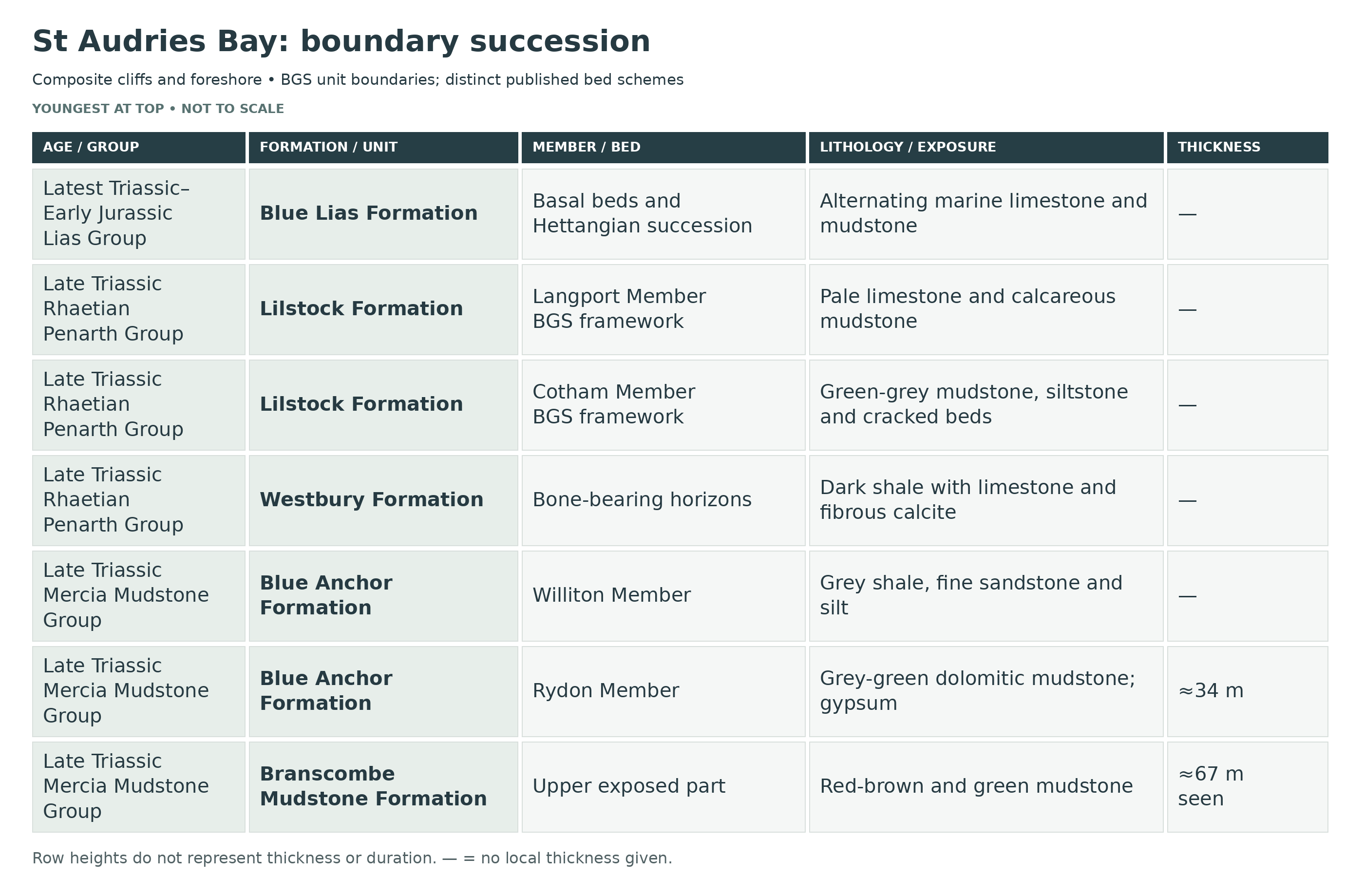
This is a detailed stratigraphic breakdown of St Audries Bay, one of Britain’s classic upper Triassic to lower Jurassic boundary sections, where the upper Branscombe Mudstone Formation, the Blue Anchor Formation, the Penarth Group and a long lower Blue Lias succession are exposed in a west-younging cliff-and-foreshore section. The locality is especially important for its Rhaetian marginal-marine and lagoonal beds, its historical role in debate over the base of the Jurassic, and the lower Hettangian ammonite succession of the wider Watchet Psiloceras planorbis type area.
Section Architecture
St Audries Bay is a composite cliff-and-foreshore section rather than a single simple vertical cliff log. The beds dip south-west, so progressively younger strata are exposed from east to west; the upper Mercia Mudstone Group dominates the eastern cliffs, the Penarth Group is best seen on the western side of the bay and on the foreshore, and the basal Blue Lias is most easily followed west of St Audries Slip and into the immediate westward continuation of the coast. Small faults, active landslip and foreshore stripping continually refresh the exposure, but they can also cause local repetition, omission and concealment.
Boundary And Nomenclature Note
The BGS Lilstock Formation is divided into Cotham and Langport members. Gallois (2009) uses a different division into Cotham, White Lias and Watchet Mudstone formations: his bed C7 lies at the base of the BGS Langport Member, so his whole C1–C10 succession cannot be relabelled as the BGS Cotham Member. Both source schemes are distinguished below. St Audries Bay was long discussed as a candidate reference section for the base of the Jurassic, but it is best treated as a key British boundary section rather than forced into a single globally definitive boundary horizon.
MERCIA MUDSTONE GROUP
Branscombe Mudstone Formation (Upper Triassic: Norian–Rhaetian)
Upper Branscombe Mudstone Formation (c. 67–68 m Seen)
The highest exposed Branscombe Mudstone Formation at St Audries Bay consists of red-brown to reddish and green mudstones with a few green siltstone beds. The mudstones weather blockily, and gypsum or anhydrite was originally abundant in nodules and veins, much of it now weathered out or represented by cavities and softer disrupted zones in the cliff; older cliff descriptions simply treated these as the red and green mudstones beneath the Tea Green Marl. Small faults affect the section, so minor repetition and omission can occur. Interpretation: low-relief continental mudflat, playa-lake and sabkha deposition close to sea level under strongly evaporitic conditions; body fossils are scarce and the unit is chiefly important as the substrate to the boundary succession above.
Blue Anchor Formation (Upper Triassic: Latest Norian–Rhaetian)
Rydon Member
Rydon Member (c. 29 m In The 2008 Account; 34 m In The GCR Compilation)
The Rydon Member forms the classic Tea Green Marl and Grey Marl interval of older Somerset usage. At St Audries Bay it consists of grey, black, green and occasional red-brown dolomitic mudstones with more resistant dolomite bands, especially in the higher part of the member, and with common gypsum crystals that have often dissolved to leave cavities and local collapse breccias. The overall colour change from the red Branscombe mudstones below to cooler green-grey dolomitic beds above is very distinctive in the cliff. Fossils are sparse through most of the member, but bivalves, gastropods and fish remains occur in its upper 2 m. The 2008 account interprets the upper part as the earliest evidence of marine transgression. Interpretation: evaporitic playa and supratidal mudflat deposition below, passing into marginal-marine conditions in the upper part.
Williton Member
Williton Member (c. 2–3 m)
The thin Williton Member rests disconformably on the Rydon Member across an erosional surface penetrated by Diplocraterion burrows. It consists predominantly of grey and dark grey shales and marls with flaser- and lenticular-bedded fine sandstone and silt, together with harder siltstones at the top; older literature commonly referred to these beds as the Sully Beds. This is the most overtly marine part of the Blue Anchor Formation at St Audries Bay. The 2008 account records fish remains, a bivalve and well-developed bioturbation in the Williton Member, together with miospores and dinoflagellate cysts near its top. The broader Blue Anchor Formation record in GCR24 includes fragmentary gastropods and vertebrate remains such as Gyrolepis and Hybodus; those formation-wide records should not all be assigned to the Williton Member. GCR24 describes the palynomorph assemblage at the top of the Williton Member as one of Britain’s most diverse from beds of that age. Interpretation: shallow marine to marginal-marine transgression across the evaporitic plain, with tidal or storm-reworked silt and sand laminae.
Thickness And Measurement Scope
The 2008 boundary dossier records about 67 m of Branscombe Mudstone and 31.18 m of Blue Anchor Formation, including about 29 m of Rydon Member and 2 m of Williton Member. The earlier GCR compilation quotes 34 m and 3 m for the two members, giving about 37 m for the Blue Anchor Formation. These published measurements should not be combined into a single precise total; local faults and different logs also affect comparisons.
PENARTH GROUP
Westbury Formation (Rhaetian)
Basal Westbury Transgressive Shale And Bone-Bed Interval (Basal c. 0.36 m)
The basal Westbury Formation marks the main Rhaetian marine transgression at St Audries Bay. The lowest c. 0.36 m is black shale with minor bone-bed material and vertebrate debris, locally with reworked coarse particles and phosphatic grains, forming the classic transgressive lag at the base of the Penarth Group. Pyrite is common, and the fauna is already fully marine in aspect. Published records from the Westbury Formation at St Audries Bay include scales and teeth of fishes such as Acrodus, Birgeria, Dalatias, Gyrolepis and Hybodus, together with rarer reptile debris. Interpretation: rapid marine flooding of the west Somerset shelf, with storm reworking and concentration of vertebrate remains into thin laggy horizons.
Main Westbury Shale–Limestone–Beef Cycles (Partial Upper Log; Not The Whole Formation)
Above the basal lag, the Westbury Formation consists of repeated black shale–dark limestone–beef cycles. Thinly laminated black and very dark grey shales with green marl wisps and partings alternate with hard dark grey earthy limestones, dark silty calcareous marl and several fibrous calcite “beef” seams with cone-in-cone structure. Crushed bivalves are common at many levels, and the fauna includes Chlamys, Protocardia and Rhaetavicula, together with ophiuroids, fish remains and marine reptile debris. Interpretation: shallow marine shelf sedimentation under fluctuating energy conditions, with low-energy organic-rich mud deposition punctuated by storm reworking, shell concentration and early diagenetic cementation.
Individual Horizons In The Partial Upper Westbury Log
Listed upwards from the lowest seen shale in GCR24. Repeated shale and calcite entries are separate horizons; the log starts within the formation and is not its complete thickness.
Basal seen black shale (0.15 m seen)
This locally measured horizon is retained separately in the published shale–limestone–marl succession.
Fibrous calcite seam (0.03 m)
This fibrous calcite “beef” seam records mineral growth within the sedimentary sequence.
Dark earthy limestone (0.13–0.20 m)
This locally measured horizon is retained separately in the published shale–limestone–marl succession.
Black shale (0.03 m)
This locally measured horizon is retained separately in the published shale–limestone–marl succession.
Dark-grey earthy limestone (0.08–0.10 m)
This locally measured horizon is retained separately in the published shale–limestone–marl succession.
Fibrous calcite seam (0.05–0.08 m)
This fibrous calcite “beef” seam records mineral growth within the sedimentary sequence.
Black shale (0.91–0.97 m)
This locally measured horizon is retained separately in the published shale–limestone–marl succession.
Fibrous calcite seam (0.03–0.08 m)
This fibrous calcite “beef” seam records mineral growth within the sedimentary sequence.
Very dark earthy limestone (0.03–0.05 m)
This locally measured horizon is retained separately in the published shale–limestone–marl succession.
Fibrous calcite seam (0.03–0.05 m)
This fibrous calcite “beef” seam records mineral growth within the sedimentary sequence.
Black shale (0.53–0.61 m)
This locally measured horizon is retained separately in the published shale–limestone–marl succession.
Fibrous calcite seam (0.03–0.05 m)
This fibrous calcite “beef” seam records mineral growth within the sedimentary sequence.
Hard silty calcareous marl (0.05–0.08 m)
This locally measured horizon is retained separately in the published shale–limestone–marl succession.
Black shale with green marl wisps (0.05–0.08 m)
This locally measured horizon is retained separately in the published shale–limestone–marl succession.
Black shale with green marl lens (0.03–0.05 m)
This locally measured horizon is retained separately in the published shale–limestone–marl succession.
Top black shale (0.05 m)
This locally measured horizon is retained separately in the published shale–limestone–marl succession.
Lilstock Formation (Rhaetian)
Conventional BGS Composite Member Log
These bottom-to-top entries reproduce the geological distinctions of the local Whittaker–Green log presented in GCR24. They belong to that particular composite exposure and are not added to the separately measured Gallois platform log.
Cotham Member
Basal pale-green marl (0.63 m)
Fissile marl contains contorted harder layers in places.
Calcareous siltstone or silty marl (0.15–0.19 m)
Hard partly laminated sediment has lens-like partings.
Green to olive mudstone (0.43 m)
Marly mudstone is more fissile at its upper and lower margins.
Contorted siltstone (0.20–0.28 m)
Hard calcareous siltstone is laminated below and slumped in its upper half.
Dark greenish-grey sandstone (0.03–0.04 m)
A thin sandstone separates the contorted interval from the overlying marl.
Fissile green marl (0.03 m)
This very thin marl separates the two sandstone horizons.
Greenish-grey sandstone (0.15–0.18 m)
Lamination occurs near the base; a cavity-bearing band lies below the top.
Upper laminated shale (0.38–0.46 m)
Greenish-grey shale becomes blockier in its uppermost part.
Langport Member
Basal porcellanous limestone (0–0.05 m)
A pale splintery fine limestone is locally absent.
Grey marl parting (0.03 m)
Marl separates the basal lens from the next limestone.
Laminated fine limestone (0.10–0.15 m)
Very fine grey limestone contains vertical calcite stringers.
Dark grey marly mudstone (0.06 m)
A shaly mudstone parting separates successive limestones.
Pyritic splintery limestone (0.10 m)
The hard grey limestone locally splits into two beds with a mudstone seam.
Grey blocky marl (0.05–0.06 m)
This thin mudstone lies below the silty limestone.
Pale-grey silty limestone (0.09–0.10 m)
A comparatively uniform limestone contains calcite stringers.
Greenish-grey silty mudstone (0.30–0.33 m)
Blocky marly mudstone becomes more fissile in its lowest part.
Four-bed limestone package (0.30–0.33 m)
Hard splintery brownish-grey limestones have irregular surfaces and a rubbly lowest bed.
Upper green-tinted mudstone (0.34 m)
Grey mudstone includes impersistent limestone beds.
Alternative Platform Log: Gallois (2009), C1–C10
The following published bed labels and measurements belong to Gallois’s alternative framework. C1–C6 correspond approximately to the conventional Cotham interval; C7 and higher lie in the BGS Langport interval. They are retained as a comparative local log, not as extra strata to be added to the BGS succession.
Bed C1 — Basal Slumped Lag Bed (0.12–0.35 m)
This published basal Cotham bed is one of the most distinctive soft-sediment horizons in the whole St Audries Bay boundary section. It is highly variable laterally, made up mainly of greenish-grey calcareous mudstones and silty mudstones with irregular slumped masses of more strongly cemented mudstone, streaks and clasts of dark grey Westbury mudstone, and an irregular erosive base. A basal lag with fish debris, sand grains and small black phosphatic pebbles is developed locally. Interpretation: abrupt change from open-marine Westbury shelf muds to very shallow Cotham lagoonal sedimentation, accompanied by erosion, reworking and local slumping of still-unconsolidated substrate.
Bed C2–C4 — Lower Cotham Slumped Mudstone And Muddy-Limestone Package (c. 1.0 m)
Beds C2 to C4 comprise a lower Cotham alternation of muddy limestones and greenish-grey weakly calcareous mudstone. Bed C3 is laminated and thinly bedded with coarse-silt lenses and isolated ripple patches, and both limestone beds may be locally slumped or internally disturbed. The interval records repeated early cementation of parts of the substrate within otherwise soft lagoonal mud. Interpretation: shallow-water lagoon or broad mudflat with intermittent traction currents, local dewatering and slump deformation.
Bed C5 — Rippled Sandstone / Calcarenite With Desiccation Cracks (0.33 m)
Bed C5 is a key marker horizon in the Somerset Cotham succession. It is a fine- to medium-grained sandstone or calcarenite with shell debris and siltstone, showing stacked wave-ripple sets, wavy bedding and mudstone partings. Small desiccation polygons occur within the bed, and larger sand-filled cracks descend from its base into the beds below. Interpretation: very shallow lagoonal or tidal-flat sand sheet laid down under wave or current action and then exposed, cracked and locally reworked.
Bed C6–C9 — Upper Cotham Mudstones And Porcellanous Limestones (c. 1.33–1.47 m)
The upper Cotham succession is thicker on the Somerset coast than in the Penarth area and at St Audries Bay forms a greenish-grey mudstone and muddy-limestone package with two especially important marker beds. Bed C7 is a thinly bedded laminated porcellanous micritic limestone that splits into thin slabs and has long been compared with a Cotham Marble equivalent; Bed C8 is laterally very variable, passing between mudstone, muddy limestone and porcellanous limestone in alternating lenticular or nodular beds; Bed C9 returns to greenish-grey mudstone. Bed C6 below remains thinly bedded, with laminated clay-rich beds alternating with more calcareous beds. Interpretation: fluctuating shallow lagoonal deposition with periodic carbonate precipitation, local emergence and strong lateral facies variability.
Bed C10 — Burrowed Hardground Limestone (0.07 m)
Bed C10 is a thin but highly significant limestone at the top of the Cotham Formation in Gallois’s scheme. It is argillaceous and strongly bioturbated, with abundant Thalassinoides and other burrow systems, and is capped by an irregular mineralized hardground with encrusting oysters. This surface marks a marked omission and forms the immediate foundation for the White Lias facies above. Interpretation: firmground to hardground development at the top of a very shallow lagoon or restricted shelf, following reduced sedimentation and marine reworking.
Gallois White Lias And Watchet Mudstone Above C10
Gallois White Lias Limestone Pair Within The Conventional Langport Interval (0.20–0.21 m In The Platform Section)
In the Gallois platform log the White Lias begins with a dense micritic laminated porcellanous limestone pair, two beds about 0.10 m thick separated by a very thin calcareous mudstone that fills hollows on the irregular top of the lower limestone. This is the classic White Lias facies of the Somerset coast and corresponds to the pale Sun Bed interval below the basal Blue Lias mudstone. The rock is hard, splintery and locally conchoidal, and forms one of the sharpest and most laterally persistent marker beds in the entire boundary succession. Interpretation: warm, very shallow carbonate lagoon or emergent carbonate-flat deposition with rapid precipitation of fine micrite.
Upper Langport Calcareous Mudstones And Shelly Limestones (0.28 m In The Platform Section; Thicker In The Composite Cliff Log)
Above the White Lias lies the interval named Watchet Mudstone Formation by Gallois. On the St Audries wave-cut platform it comprises pale grey to pale grey-green calcareous mudstone infilling hollows on the White Lias, a tightly cemented argillaceous limestone with moulds of Liostrea, Modiolus and other bivalves, and a further pale calcareous mudstone at the top; in the classical composite cliff log the same interval expands into several green-tinged marls and hard splintery limestones with pyrite and calcite stringers. It forms the hard grey calcareous mudstone package immediately beneath the fissile basal Blue Lias shale. Interpretation: slightly deeper but still very shallow restricted marine shelf or lagoonal mud deposition above the White Lias carbonate-flat phase.
Gallois Watchet Mudstone Sub-beds, Oldest To Youngest
Basal mudstone (0.10 m). Pale greyish-green mudstone fills hollows in the uneven White Lias surface below.
Middle shelly limestone (0.08–0.10 m). Tightly cemented, medium-grey argillaceous limestone contains abundant moulds of Liostrea, Modiolus and other bivalves.
Upper calcareous mudstone (0.08–0.10 m). Pale-grey mudstone weathers with a subconchoidal fracture, contains common crushed bivalve fragments and fills hollows in the bed below. Gallois gives 0.28 m for the formation in this platform section; individual ranges reflect local variation and should not be added as a separate succession.
Thickness Scope: Published Full Westbury Measurements Are About 9.6–10.6 m; The Short Upper Log Is Incomplete. Lilstock Is About 3 m In The Conventional BGS Scheme
Individual Beds Within The Grouped Platform Packages
Bed C2 (0.20 m)
Muddy limestone, locally slumped, forms a more strongly cemented part of the lower package.
Bed C3 (0.60 m)
Greenish-grey mudstone with thin lamination, silt lenses and isolated coarse-silt ripples is locally slumped.
Bed C4 (0.20 m)
Muddy limestone resembles a cemented version of C3, with isolated siltstone ripples and thin lenses; local slumping persists.
Bed C6 (0.50–0.60 m)
Greenish-grey mudstone alternates between laminated clay-rich layers and thicker, more calcareous layers.
Bed C7 (0.08–0.12 m)
Laminated porcellanous micritic limestone splits into thin slabs. This is the critical horizon placed at the Langport base in the BGS scheme.
Bed C8 (0.45 m)
Lenticular or nodular beds vary laterally from weakly cemented mudstone through muddy limestone to porcellanous limestone.
Bed C9 (0.30 m)
Greenish-grey mudstone, weakly calcareous in places, underlies the burrowed C10 limestone.
LIAS GROUP
Blue Lias Formation (Triassic–Jurassic Boundary Interval And Lower Jurassic)
Blue Lias Bed Numbering Note
The numbered beds below follow the formal Whittaker & Green bed numbering used throughout the west Somerset Lower Jurassic literature. At St Audries Bay the lowest Blue Lias is best seen in the cliff and foreshore west of St Audries Slip, and because the beds dip south-west and are locally faulted, the succession is followed laterally rather than as one single simple vertical face.
Beds 1–7 — Ammonite-Free Basal Interval (Basal c. 5 m)
Beds 1–7 are the ammonite-free basal interval. Historically the term Pre-planorbis Beds included beds 1–12; subsequent discoveries demonstrated ammonites in beds 8–12. At the very base, the Blue Lias begins at the sharp planar base of a fissile organic-rich mudstone resting on the hard grey calcareous mudstone at the top of the Langport Member; in the platform log this basal fissile mudstone is about 1.40 m thick and is capped by a 0.11 m tightly cemented bluish-grey argillaceous limestone. Higher beds in this lower package continue as mudstone–nodular limestone couplets. The macrofauna is dominated by bivalves, especially Liostrea hisingeri, with Camptonectes, Protocardia and Pteromya also recorded, but unequivocal ammonites were not recognized in the original scheme. Interpretation: normal-marine offshore shelf mud deposition with repeated early cementation into nodular limestones, representing the lowermost Blue Lias boundary interval.
Beds 8–12 — Lower Psiloceratid Boundary Interval
Beds 8–12 yield the lowest psiloceratids known from the St Audries Bay section and are critical to boundary work. The detailed bed 8 and bed 9 species identifications belong to adjacent Doniford specimens. St Audries specimens from those levels are too poorly preserved for comparable species determinations. Lithologically the interval still belongs to the basal Blue Lias rhythm of mudstones and rather nodular limestones, and preservation of ammonites is generally poorer than in the higher laminated mudstones. Stratigraphic significance: this is the lowest ammonite-bearing part of the St Audries Bay boundary succession and the level on which much of the British base-Jurassic discussion at the site has turned.
Beds 13–19 — Main Psiloceras planorbis Interval
Beds 13–19 contain unequivocal Psiloceras planorbis and form a classic lower Hettangian ammonite interval in the St Audries cliff section. The local log records P. planorbis, Liostrea irregularis, echinoid fragments and thin-shelled bivalves compared with Anningella in beds 13–15, and P. planorbis in beds 17–19. The intervening bed 16 is limestone. The broader Planorbis-zone fauna described for the Blue Anchor–Lilstock coast also includes Diademopsis and Eodiadema bechei, but that regional list does not establish those taxa in each of these St Audries beds.
Beds 20–24 — Upper Planorbis Subzone, Including Bed 24
Beds 20–24 form the upper part of the Planorbis Subzone. In the local measured cliff log, beds 20–22 comprise 0.28 m of limestone and beds 23–24 comprise 1.93 m of shale with abundant Psiloceras planorbis, P. plicatulum, Anningella faberi, echinoid fragments and fish remains. The wider-coast GCR account describes bed 24 as 2 m or more of indurated laminated mudstone containing crushed iridescent ammonites, and records small pyritised Heterastraea colonies and vertebrate remains in the regional Planorbis-zone succession. Those broader records and measurements should not be substituted for the St Audries cliff log.
Beds 25–42 — Johnstoni Subzone
Bed 25 is a limestone band marking the first appearance of Caloceras and therefore the base of the Johnstoni Subzone. Beds 25–42 comprise limestones and mudstones, including hard laminated mudstone horizons that have yielded Caloceras johnstoni in Bed 36 and C. intermedium in Bed 37. The GCR synthesis gives 3.4 m for the subzone, whereas the separate thicknesses in the detailed Whittaker–Green log below sum to about 4.1 m for beds 25–42. Published placements of the subzone base have also varied between beds 25, 29 and 30; retain the source-specific bed descriptions rather than treating these summaries as interchangeable measurements. Interpretation: continued offshore Blue Lias deposition, with laminated mudstone episodes and recurring limestone development in a fully marine shelf setting.
Beds 43–79 — Liasicus Zone (c. 28 m)
The appearance of Waehneroceras sensu lato in Bed 43 marks the base of the Liasicus Zone. Beds 43–79 total about 28 m and are dominated, especially below about Bed 69, by mudstones with only subordinate limestones. Laqueoceras appears around Bed 67 and marks the boundary between the Portlocki and Laqueus subzones. The wider Blue Anchor–Lilstock coast synthesis describes a more diverse Liasicus-zone fauna than in the Planorbis-zone beds below, including Camptonectes, Gervillia, Lucina, Liostrea, Modiolus, Plagiostoma, Pseudolimea and the earliest Gryphaea cf. obliquata reported in that regional succession. Interpretation: relatively expanded offshore mudstone deposition in the Bristol Channel Basin, with fewer limestones and a more mature early Jurassic marine benthos.
Beds 80–145 — Angulata Zone (c. 40 m To The Hettangian–Sinemurian Boundary Interval)
The base of the Angulata Zone is taken at the first appearance of Schlotheimia cf. amblygonia in Bed 80. From Bed 80 to Bed 145, a further c. 40 m of mudstones and nodular limestones are documented in the regional west Somerset reference succession, with the Complanata Subzone beginning at Bed 95 and the Depressa Subzone at Bed 134. The fauna is relatively sparse compared with lower Hettangian levels, but Gryphaea arcuata becomes increasingly common and the brachiopod Calcirhynchia calcaria is characteristic. These beds lead up to the Hettangian–Sinemurian boundary interval in Bed 145 in the regional framework; the formal GSSP is east of this bay at East Quantoxhead. Interpretation: continued open-marine Blue Lias deposition in a thick, basinward Hettangian succession.
Total Thickness Of The Blue Lias Formation Covered Here: About 74 Metres In The St Audries–Doniford Cliff Section, With Higher Intervals In Doniford Foreshore Exposures, With Higher Lower Jurassic Beds Exposed In Other Fault Blocks Along The Coast; East Quantoxhead And Lilstock Are East Of This Bay
Measured St Audries–Doniford Scope
The 2008 ISJS dossier describes about 74 m in the approximately 1.2 km cliff section from St Audries towards Doniford. Beds 80–135 account for about 32.8 m in the cliffs; beds 136–145, about 8.4 m, and beds 146–158, about 7.5 m, are measured on the Doniford foreshore. The formal Sinemurian GSSP lies about 3.5 km east-north-east at East Quantoxhead. These scopes must remain separate from a single St Audries cliff measurement.
Beds 13–15 — Locally Measured Shale Interval
The ISJS account records 0.61 m of shale between 5.42 and 6.03 m above the Blue Lias base in the local measured succession. This is an individually scoped interval within the broader planorbis-bearing package described above.
Individual Blue Lias Marker Horizons
The lower markers accompany the St Audries basal succession. The entries explicitly labelled regional belong to the wider correlated Somerset coast and are not an assertion of a complete St Audries cliff exposure.
Bed 8 — Lowest Local Psiloceras
Ammonites occur at this level, but the St Audries material is too poorly preserved for the detailed species comparison established from Doniford specimens.
Bed 9 — Neophyllites And Early Psiloceratids
The detailed Neophyllites and early Psiloceras determinations belong to adjacent Doniford specimens; St Audries bed 9 specimens are less securely identified.
Bed 24 — Laminated Planorbis Mudstone
This indurated laminated mudstone records abundant crushed iridescent Psiloceras in the regional correlation. The separately discussed grouped interval retains its detailed fossil and thickness context.
Bed 25 — Basal Johnstoni Limestone
The incoming of Caloceras marks this limestone and the base of the Johnstoni Subzone.
Bed 36 — Caloceras johnstoni Horizon
Hard laminated mudstone carries the published Caloceras johnstoni record.
Bed 37 — Caloceras intermedium Horizon
The adjacent numbered mudstone horizon carries the distinct Caloceras intermedium record.
Regional Bed 43 — Liasicus-Zone Marker
The incoming of Waehneroceras sensu lato identifies the regional zonal boundary; it is not a separate formal member.
Regional Bed 67 — Laqueus-Subzone Marker
The first Laqueoceras record is placed around this bed in the regional framework.
Regional Bed 80 — Angulata-Zone Marker
The source uses Schlotheimia cf. amblygonia to identify this regional boundary.
Regional Bed 95 — Complanata-Subzone Base
This numbered marker begins the regional Complanata subdivision of the upper Hettangian.
Regional Bed 134 — Depressa-Subzone Base
This is the published regional lower boundary of the Depressa interval below bed145.
Depositional Environment
The St Audries Bay succession records a major environmental shift across the late Triassic–early Jurassic transition. The upper Branscombe Mudstone Formation represents continental playa-lake and sabkha deposition on a low-relief evaporitic plain; the Rydon Member passes from evaporitic lake and mudflat facies into marginal-marine conditions in its upper part; the Williton Member records more clearly developed shallow-marine deposition. The Westbury Formation marks a fully marine transgression across the shelf, with black shales, storm-reworked shell debris, beef seams and vertebrate-rich lag deposits. The Cotham Member records a return to very shallow lagoonal, tidal-flat and intermittently emergent conditions, including dewatering, slumping and desiccation cracking, while the Langport Member formed in warm very shallow carbonate lagoons and restricted shelf settings. The Blue Lias Formation then records establishment of an offshore early Jurassic sea in the Bristol Channel Basin, with alternating mudstones and limestones, progressive development of ammonite zonation from the lowest psiloceratids upward, and one of the fullest British Hettangian successions known onshore.
Composite-Section Scope: Do Not Sum Incompatible Platform, Cliff And Regional Logs Into One Exposed Thickness
Published BGS Measured Cliff Log: Beds 1–135
Whittaker and Green describe the traverse starting near Doniford at ST 0979 4332 and working east. Their Figure 13 identifies beds 1–135 as measured in the St Audries cliffs; the ISJS account scopes this as the approximately 1.2 km St Audries–Doniford cliff section. This is the exact local traverse, not the whole 20 km Somerset composite. Entries follow the source from youngest to oldest. Bed numbers, ranges and unnumbered sub-beds are kept distinct. Fossil names and zone labels are historical identifications as published, not a new taxonomic revision. Thicknesses are local measurements or estimates, not present-day exposure guarantees.
Blue Lias Formation
Historical source division: Schlotheimia angulata Zone
Blue Lias Formation
Published bed 130–135 — Shales with two limestone bands at middle and base (1.12 m)
Shales with two limestone bands at middle and base.
Published bed 129 — Shale with nodular and lenticular limestones near the base (1.85 m)
Shale with nodular and lenticular limestones near the base.
Published bed 128 — Limestone (0.10–0.15 m)
This limestone interval is lenticular in places.
Published bed 127 — Shale (0.76 m)
The recorded interval consists of shale.
Published bed 126 — Limestone (0.30–0.33 m)
The limestone contains the brachiopod Calcirhynchia sp., as listed in the 2008 reproduction of the local measured log.
Published bed 124–125 — Shale (2.04 m)
Shale. Large Schlotheimia.
Published bed 117–123 — Limestones in three bands alternating with shales (1.14 m)
Limestones in three bands alternating with shales.
Published bed 115–116 — Shale (2.87 m)
The recorded interval consists of shale.
Published bed 107–114 — Limestones in four bands alternating with shales (1.26 m)
Limestones in four bands alternating with shales.
Published bed 106 — Shale (1.50 m)
The recorded interval consists of shale.
Published bed 103–105 — Limestones in two bands with shale between (0.43 m)
Limestones in two bands with shale between.
Published bed 102 — Shale (1.22 m)
The recorded interval consists of shale.
Published bed 101 — Limestones with a shale parting (0.46 m)
Limestones with a shale parting.
Published bed 100 — Shale (0.41 m)
The recorded interval consists of shale.
Published bed 99 — Limestones in three bands separated by shales (0.69 m)
Limestones in three bands separated by shales.
Published bed 98 — Shale (0.41 m)
The recorded interval consists of shale.
Published bed 97 — Limestone (0.33 m)
The recorded interval consists of limestone.
Published bed 96 — Shales with three limestone bands (2.43 m)
Shales with three limestone bands.
Published bed 94–95 — Limestones in two bands alternating with shale (1.93 m)
Limestones in two bands alternating with shale.
Published bed 93 — Limestone (0.05–0.10 m)
This limestone interval is lenticular.
Published bed 92 — Shale (0.91 m)
The recorded interval consists of shale.
Published bed 91 — Limestone (0.05–0.10 m)
This limestone interval is lenticular.
Shale (0.13 m)
The recorded interval consists of shale.
Limestone (0.09 m)
This limestone interval is slabby and regular.
Published bed 90 — Shale (1.40 m)
The recorded interval consists of shale.
Published bed 89 — Limestones in five bands alternating with shales (1.59 m)
Limestones in five bands alternating with shales.
Published bed 88 — Shale (1.63 m)
The recorded interval consists of shale.
Published bed 87 — Limestones in three bands separated by shales (0.84 m)
Limestones in three bands separated by shales.
Published bed 80–86 — Shales with two bands of limestone (4.78 m)
Shales with two bands of limestone.
Historical source division: Alsatites liasicus Zone
Published bed 79 — Limestones in nine bands alternating with shales (2.46 m)
Limestones in nine bands alternating with shales.
Published bed 78 — Shales with three limestone bands (2.10 m)
Shales with three limestone bands.
Published bed 77 — Limestone (0–0.10 m)
This limestone interval is lenticular.
Published bed 76 — Shale (1.09 m)
The recorded interval consists of shale.
Published bed 75 — Limestone (0.20–0.28 m)
This limestone interval is in places present as two beds.
Published bed 74 — Shale (1.09 m)
The recorded interval consists of shale.
Published bed 73 — Limestones with a mudstone parting (0.38 m)
Limestones with a mudstone parting.
Published bed 72 — Mudstone (0.43 m)
The recorded interval consists of mudstone.
Published bed 71 — Limestone (0.05–0.10 m)
This limestone interval is lenticular.
Published bed 70 — Shale (0.20–0.25 m)
The recorded interval consists of shale.
Published bed 69 — Limestone (0.23–0.25 m)
This limestone interval is persistent but slightly lenticular in places.
Published bed 66–68 — Shales (4.37 m)
This shales interval is mainly fissile but some calcareous and blocky. Laqueoceras laqueus, Waehneroceras cf. megastoma and W. portlocki.
Published bed 65 — Limestone (0.08–0.10 m)
This limestone interval is persistent.
Published bed 62–64 — Shale (2.28 m)
This shale interval is blocky in lowest 0.30 m. Waehneroceras cf. megastoma and W. portlocki.
Published bed 57–61 — Shale (2.21 m)
This shale interval is with flat limestone lenses and nodules in topmost 0.05 m. Heterastrea sp., Waehneroceras megastoma, W. portlocki and Psilophyllites sp.
Published bed 56 — Mudstone (0.51 m)
The recorded interval consists of mudstone.
Published bed 55 — Limestone (0–0.15 m)
This limestone interval is persistent nodule bed.
Published bed 50–54 — Shale and calcareous mudstone (4.53 m)
Shale and calcareous mudstone. Psilophyllites? and Waehneroceras sp.
Published bed 49 — Shale and mudstone (0.46 m)
Shale and mudstone, very calcareous.
Limestone (0–0.20 m)
This limestone interval is elongated large nodules.
Published bed 46–48 — Shale and mudstone (0.71 m)
Shale and mudstone. Lucina limbata.
Published bed 45 — Shale (2.23 m)
Shale. Psilophyllites sp. and Waehneroceras sp.
Limestone nodules (0–0.10 m)
Limestone nodules.
Published bed 43–44 — Shale and mudstone (2.67 m)
Shale and mudstone. Camptonectes sp. and Plagiostoma sp.; Waehneroceras prometheus at the base.
Historical source division: Psiloceras planorbis Zone
Published bed 38–42 — Limestones in two bands with mudstone parting (0.41 m)
Limestones in two bands with mudstone parting.
Published bed 36–37 — Shale (1.42 m)
This shale interval is blocky in the topmost 0.48 m. Caloceras johnstoni and C. intermedium.
Published bed 35 — Limestones in two bands with a shale parting (0.22 m)
Limestones in two bands with a shale parting.
Published bed 32–34 — Shales with a limestone band (0.29 m)
Shales with a limestone band.
Published bed 31 — Limestone (0.10 m)
This limestone interval is ‘beefy’.
Shale (0.15–0.18 m)
The recorded interval consists of shale.
Limestone (0.19 m)
The recorded interval consists of limestone.
Published bed 30 — Shale (0.38–0.46 m)
Shale. Caloceras sp.
Published bed 25–29 — Limestones in three bands alternating with mudstones (0.89 m)
Limestones in three bands alternating with mudstones.
Published bed 23–24 — Shale (1.93 m)
Shale. Abundant Psiloceras planorbis, P. plicatulum, Anningella faberi, echinoid and fish fragments.
Published bed 20–22 — Limestone (0.28 m)
The recorded interval consists of limestone.
Published bed 17–19 — Shale (0.64 m)
Shale. P. planorbis.
Published bed 16 — Limestone (0.30 m)
The recorded interval consists of limestone.
Published bed 13–15 — Shale (0.61 m)
Shale. P. planorbis, Liostrea irregularis, echinoid fragments and thin-shelled bivalves cf. Anningella.
Historical source division: Pre-planorbis Beds (Triassic)
Published bed 12 — Limestone in one or two nodular beds (0.13–0.20 m)
Limestone in one or two nodular beds.
Published bed 9–11 — Shale (0.20–0.23 m)
The recorded interval consists of shale.
Published bed 8 — Limestone (0.22 m)
This limestone interval is slightly lenticular.
Published bed 7 — Shales with a limestone band near base (0.78 m)
Shales with a limestone band near base.
Limestone (0.06 m)
This limestone interval is passing laterally into hard calcareous mudstone.
Shale (0.24 m)
Shale. Protocardia sp. and echinoid fragments.
Limestone or hard calcareous mudstone (0.08 m)
Limestone or hard calcareous mudstone.
Shale (0.05 m)
The recorded interval consists of shale.
Limestone (0.08 m)
The recorded interval consists of limestone.
Shale (0.44 m)
Shale. Pteromya tatei.
Published bed 6 — Limestone (0.10–0.17 m)
This limestone interval is persistent but lenticular.
Shale (0.17 m)
This shale interval is with nodular limestone up to 0.13 m thick and with bivalves.
Limestone (0.30–0.33 m)
This limestone interval is massive, somewhat ‘beefy’.
Published bed 5 — Shale (0.43 m)
This shale interval is with persistent shelly bands and silty laminae. Plagiostoma sp. and Pteromya tatei.
Published bed 4 — Limestone (0–0.08 m)
This limestone interval is impersistent.
Shale parting (0–0.03 m)
Shale parting, not always present.
Limestone (0.38–0.46 m)
This limestone interval is with shelly bands; somewhat ‘beefy’ and laminated in places.
Published bed 3 — Shale (0.23 m)
The recorded interval consists of shale.
Published bed 2 — Limestone (0.11 m)
This limestone interval is laminated.
Published bed 1 — Shale with silty laminations (1.42 m)
Shale with silty laminations.
Additional BGS Measured Logs: Earlier Beds And Lateral Sections
The following supplementary logs preserve the finer published detail of the St Audries exposures described by Whittaker and Green (1983). Each log follows the original source from youngest to oldest; the succession therefore runs downwards through time within each log. They complement the descriptions above. Alternative cliff and foreshore sections overlap and must not be added together. Quoted thicknesses are historical measurements, not guarantees of present exposure. Fossil names are the historical identifications in the source, with obvious transcription errors corrected; they are not a new taxonomic revision.
MERCIA MUDSTONE GROUP
Branscombe Mudstone Formation
Red And Green Mudstone Cliff Log Below The Blue Anchor Formation
This log was measured in the St Audries cliffs west of the Blue Ben Fault, between ST 1055 4312 and ST 1200 4375. It records about 67 m below the Blue Anchor Formation. The labels A1–A29 identify beds sampled for palynology; they are sample labels, not a formal numbered-bed scheme. The first entry is immediately below the Blue Anchor Formation; the last is the lowest exposed layer in the published log.
Unnumbered mudstone layer (0.20 m)
Mudstone, red, with indistinct top and bottom.
Sampled layer A29 — Mudstone (0.61 m)
Mudstone, green, blocky. Hard, massive and moderately well-jointed for 0.15 m at 0.25 m from the top. Rather more fissile in the lowest 0.20 m (A29) (In St. Audrey’s Bay section, samples were collected from the numbered beds for palynological examination).
Unnumbered siltstone layer (0.15 m)
Siltstone, greenish grey, hard and massive.
Unnumbered siltstone layer (0.09 m)
Siltstone, greenish grey, moderately laminated and with siltstone nodules in the lowest 0.02 m.
Unnumbered mudstone layer (0.32 m)
Mudstone, pale greenish grey, rather soft.
Unnumbered mudstone layer (0.53 m)
Mudstone, green, blocky, and with an indistinct 0.03-m red band 0.15 m above the base.
Unnumbered mudstone layer (0.23 m)
Mudstone, red and blocky, but becoming purple and green in the lowest 0.08 m.
Unnumbered mudstone layer (0.61 m)
Mudstone, green, blocky.
Unnumbered mudstone layer (0.84 m)
Mudstone, red, with some green patches.
Sampled layer A28 — Mudstone (0.20 m)
Mudstone, green, indistinct base (A28).
Unnumbered mudstone layer (1.40 m)
Mudstone, red, alternating with green mudstone, in beds with indistinct tops and bases.
Unnumbered mudstone layer (0.15 m)
Mudstone, green, silty and blocky.
Sampled layer A27 — Mudstone (0.06 m)
Mudstone, green, fissile and shaly; laminated with silt wisps and partings (A27).
Unnumbered mudstone layer (0.34 m)
Mudstone, green, blocky.
Unnumbered mudstone layer (0.43 m)
Mudstone, red, with a few green patches, gradual colour change at base.
Unnumbered mudstone layer (1.57 m)
Mudstone, green, alternating with red mudstone.
Sampled layer A26 — Mudstone (0.20 m)
Mudstone, green, blocky, but with a 0.09-m-thick more shaly and darker green band in the middle (A26).
Unnumbered mudstone layer (0.08 m)
Mudstone, pale pink, hard.
Unnumbered mudstone layer (0.15 m)
Mudstone, dark green, blocky.
Unnumbered mudstone layer (0.05 m)
Mudstone, pale red.
Unnumbered mudstone layer (0.05 m)
Mudstone, green, soft and blocky.
Unnumbered mudstone layer (0.02 m)
Mudstone, green, harder than above.
Unnumbered mudstone layer (0.20 m)
Mudstone, red.
Unnumbered mudstone layer (0.56 m)
Mudstone, green, blocky; hard and silty above a pink band which is 0.15 m thick 0.10 m above the base.
Unnumbered mudstone layer (0.78 m)
Mudstone, red, with 0.25 m green mudstone.
Sampled layer A25 — Mudstone (0.15 m)
Mudstone, dark greyish green (A25).
Unnumbered mudstone layer (0.13 m)
Mudstone, red.
Unnumbered siltstone layer (0.28 m)
Siltstone, greenish grey, rather hard and with cavities.
Unnumbered mudstone layer (0.29 m)
Mudstone, red.
Sampled layer A24 — Mudstone (0.16 m)
Mudstone, dark greenish grey, silty, with some poor lighter grey siltstone laminae near the base (A24).
Unnumbered mudstone layer (0.41 m)
Mudstone, red, with 0.06 m green mudstone.
Sampled layer A23 — Mudstone (1.91 m)
Mudstone, greyish green, silty and blocky with some red patches and four pale pink bands (A23).
Sampled layer A22 — Mudstone (0.06 m)
Mudstone, dark grey to black, silty (A22).
Unnumbered siltstone layer (0.11 m)
Siltstone, grey, hard.
Unnumbered mudstone layer (0.16 m)
Mudstone, greyish green, coarsely blocky.
Sampled layer A21 — Mudstone (0.13 m)
Mudstone, dark grey (A21).
Unnumbered mudstone layer (0.36 m)
Mudstone, green, coarsely blocky.
Sampled layer A20 — Mudstone (0.23 m)
Mudstone, green, fairly fissile (A20).
Unnumbered mudstone layer (0.36 m)
Mudstone, green, coarsely blocky.
Unnumbered siltstone layer (0.18 m)
Siltstone, buffish grey, hard, with poor laminae and partings.
Sampled layer A19 — Siltstone (0.23 m)
Siltstone, grey and greenish grey, hard and poorly laminated (A19).
Unnumbered mudstone layer (0.38 m)
Mudstone, green, hard and silty; grey in the top 0.05 m.
Unnumbered mudstone layer (0.68 m)
Mudstone, pinkish red, alternating with green mudstone.
Sampled layer A18 — Mudstone (0.20 m)
Mudstone, greyish green, silty and blocky (A18).
Unnumbered mudstone layer (0.23 m)
Mudstone, green, with red traces near the top.
Unnumbered mudstone layer (0.10 m)
Mudstone, red.
Sampled layer A17 — Mudstone (0.20 m)
Mudstone, dark green, finely blocky (A17).
Unnumbered mudstone layer (0.15 m)
Mudstone, greyish green, coarsely blocky.
Unnumbered siltstone layer (0.13 m)
Siltstone, greenish grey, very hard.
Unnumbered mudstone layer (0.33 m)
Mudstone, green, silty and blocky.
Unnumbered mudstone layer (0.40 m)
Mudstone, red, with 0.14 m green mudstone.
Sampled layer A16 — Mudstone (0.21 m)
Mudstone, green, coarsely blocky in the lowest 0.10 m, finer and darker green above (A16).
Unnumbered mudstone layer (0.03 m)
Mudstone, red, with green patches.
Unnumbered mudstone layer (0.26 m)
Mudstone, green, silty and with red patches.
Unnumbered mudstone layer (0.09 m)
Mudstone, red, with green patches.
Unnumbered mudstone layer (0.19 m)
Mudstone, green, with red patches and some hard siltstone wisps.
Unnumbered mudstone layer (0.38 m)
Mudstone, red, coarsely blocky.
Unnumbered mudstone layer (0.15 m)
Mudstone, green, silty and with a 0.05-m siltstone band.
Unnumbered mudstone layer (0.13 m)
Mudstone, red, blocky.
Unnumbered siltstone layer (0.15 m)
Siltstone, green, blocky and somewhat laminated in the lowest 0.06 m.
Unnumbered mudstone layer (0.03 m)
Mudstone, purple, faintly laminated, with a green band.
Sampled layer A15 — Siltstone (0.09 m)
Siltstone, green, laminated (A15).
Unnumbered mudstone layer (0.26 m)
Mudstone, purplish red.
Sampled layer A14 — Siltstone (0.18 m)
Siltstone, green, strongly laminated in the middle 0.05 m (A14).
Unnumbered mudstone layer (0.48 m)
Mudstone, red.
Sampled layer A13 — Siltstone (0.18 m)
Siltstone, greyish green and hard in the middle 0.15 m but marly in the topmost and bottom-most 0.03 m (A13).
Unnumbered mudstone layer (0.86 m)
Mudstone, red, with green patches particularly in the top 0.15 m.
Sampled layer A12 — Mudstone (0.15 m)
Mudstone, green, soft, slightly fissile and darker in colour in the middle 0.05 m (A12).
Unnumbered mudstone layer (1.09 m)
Mudstone, red, blocky and with green patches.
Unnumbered mudstone layer (0.04 m)
Mudstone, green, with red patches.
Unnumbered mudstone layer (0.10 m)
Mudstone, green.
Unnumbered mudstone layer (0.71 m)
Mudstone, red, with green patches.
Sampled layer A11 — Siltstone (0.69 m)
Siltstone, green, with red patches and patchy red bands (A11).
Unnumbered mudstone layer (3.11 m)
Mudstone, red, with green patches.
Unnumbered mudstone layer (0.03 m)
Mudstone, green, mottled.
Unnumbered siltstone layer (0.11 m)
Siltstone, green, hard.
Unnumbered mudstone layer (0.86 m)
Mudstone, red, with green patches and a 0.05-m green band at the top.
Unnumbered siltstone layer (0.23 m)
Siltstone, green, very hard, massive.
Sampled layer A10 — Mudstone (0.04 m)
Mudstone, green (A10).
Unnumbered siltstone layer (0.12 m)
Siltstone, green, hard.
Unnumbered mudstone layer (0.30 m)
Mudstone, red, coarsely blocky.
Unnumbered mudstone layer (0.09 m)
Mudstone, red, with abundant green patches.
Unnumbered mudstone layer (0.38 m)
Mudstone, red, with green patches and spots.
Unnumbered mudstone layer (0.10 m)
Mudstone, red, with many green patches.
Unnumbered mudstone layer (0.98 m)
Mudstone, red, with 0.08 m green mudstone.
Sampled layer A9 — Mudstone (0.15 m)
Mudstone, green, blocky; laminated in the middle part (A9).
Unnumbered mudstone layer (0.81 m)
Mudstone, red.
Unnumbered mudstone layer (0.85 m)
Mudstone, red, with green patches.
Unnumbered mudstone layer (0.04 m)
Mudstone, green, silty.
Unnumbered mudstone layer (0.33 m)
Mudstone, red.
Sampled layer A8 — Siltstone (0.20 m)
Siltstone, green, hard and marly (A8).
Unnumbered mudstone layer (0.98 m)
Mudstone, red.
Unnumbered mudstone layer (0.47 m)
Mudstone, red, with green patches near top.
Unnumbered mudstone layer (0.09 m)
Mudstone, green.
Unnumbered mudstone layer (1.02 m)
Mudstone, red, blocky, with ‘fish eyes’ and green patches.
Unnumbered mudstone layer (0.44 m)
Mudstone, red, with 0.08 m green mudstone.
Unnumbered mudstone layer (0.16 m)
Mudstone, green, blocky.
Sampled layer A7 — Siltstone (0.08 m)
Siltstone, green, laminated (A7).
Unnumbered mudstone layer (0.03 m)
Mudstone, green, silty and blocky.
Unnumbered mudstone layer (0.16 m)
Mudstone, red, with green patches.
Unnumbered mudstone layer (0.15 m)
Mudstone, green, hard and silty.
Unnumbered mudstone layer (0.42 m)
Mudstone, red, blocky.
Sampled layer A6 — Siltstone (0.15 m)
Siltstone, green, laminated in the lowest 0.06 m (A6).
Unnumbered mudstone layer (0.36 m)
Mudstone, red, coarsely blocky.
Unnumbered mudstone layer (0.10 m)
Mudstone, green, blocky.
Unnumbered mudstone layer (1.50 m)
Mudstone, red, with green patches and spots.
Unnumbered mudstone layer (1.35 m)
Mudstone, red, coarsely blocky.
Unnumbered mudstone layer (2.99 m)
Mudstone, red, blocky, and with many green patches near the top.
Unnumbered mudstone layer (0.08 m)
Mudstone, red, rich in green spots and patches.
Unnumbered mudstone layer (1.78 m)
Mudstone, red, blocky, with ‘fish eyes’.
Sampled layer A5 — Mudstone (0.15 m)
Mudstone, mainly green but with red patches (A5).
Unnumbered mudstone layer (1.35 m)
Mudstone, red, blocky, with ‘fish eyes’.
Unnumbered mudstone layer (0.15 m)
Mudstone, mainly green but with red patches.
Unnumbered mudstone layer (0.56 m)
Mudstone, red.
Unnumbered mudstone layer (3.05 m)
Mudstone, red, blocky, with green spots and patches.
Unnumbered mudstone layer (2.69 m)
Mudstone, red, with green spots.
Unnumbered mudstone layer (0.10 m)
Mudstone, brick red, silty, with many green patches.
Unnumbered mudstone layer (0.85 m)
Mudstone, red, soft and silty.
Sampled layer A4 — Mudstone (3.98 m)
Mudstone, red, blocky, with ‘fish eyes’; softer bands with green patches present (A4).
Sampled layer A3 — Siltstone (0.22 m)
Siltstone, green, hard and sandy; red mottles near base (A3).
Unnumbered mudstone layer (0.20 m)
Mudstone, red, blocky, mottled near the top.
Unnumbered siltstone layer (0.09 m)
Siltstone, green, hard and sandy, with red mottles.
Unnumbered mudstone layer (0.41 m)
Mudstone, red, blocky, with small ‘fish eyes’.
Sampled layer A2 — Sandstone (0.04 m)
Sandstone, green, hard and silty (A2).
Unnumbered mudstone layer (0.86 m)
Mudstone, red, blocky.
Sampled layer A1 — Mudstone (0.23 m)
Mudstone, green, silty and blocky (A1).
Unnumbered mudstone layer (4.57 m)
Mudstone, red, blocky.
Unnumbered mudstone layer (0.08 m)
Mudstone, red, sandy.
Unnumbered mudstone layer (0.15 m)
Mudstone, red, with green patches, hard.
Unnumbered mudstone layer (3.66 m)
Mudstone, red, blocky, with green ‘fish eyes’ seen.
The A13 sampled siltstone retains the source’s reported 0.18 m thickness and its description of a hard middle 0.15 m with marly top and bottom margins of 0.03 m each. Those component figures do not add exactly; no revised thickness is inferred here. The 2008 account additionally highlights a roughly 4 m green-to-grey interval, including dark-grey mudstone, between about 15 and 11 m below the formation top; this is part of the succession above, not an extra unit.
Blue Anchor Formation
Cliff Log Immediately West Of St Audries Slip
This section was measured west of the Slip at ST 1053 4314. Its beds dip west-south-west and crop out in the cliff and adjacent foreshore. The memoir uses the historical lithological labels Grey Marl and Tea Green Marl, and informal units A, B and C. These are preserved below without treating them as additional formations or equating the entire Grey Marl with the modern Williton Member. The modern Rydon–Williton interpretation and differing published total thicknesses are discussed above.
Historical Source Division: Grey Marl
Unnumbered siltstone layer (0.20 m)
Siltstone, grey, hard, calcareous, with poor laminations and wisps of very dark grey marl in top 0.13 m. A fairly massive and poorly jointed bed.
Unnumbered siltstone layer (0.25 m)
Siltstone, pale grey, hard, rather blocky and poorly jointed; rather irregular base in places.
Unnumbered marl layer (0.12 m)
Marl, very dark grey, blocky, with wisps of paler grey marl.
Unnumbered shale layer (0.03 m)
Shale, black.
Unnumbered marl layer (0.28 m)
Marl, very dark grey, blocky.
Unnumbered siltstone layer (0.09–0.10 m)
Siltstone, dark grey, hard, marly, with a black shale parting in the middle.
Unnumbered marl layer (0.10–0.13 m)
Marl, black, shaly.
Unnumbered siltstone layer (0.13 m)
Siltstone, grey, hard, with wisps of black marl; poorly jointed.
Unnumbered marl layer (0.20 m)
Marl, grey, shaly and with black marl partings.
Unnumbered shale layer (0.23 m)
Shale, black, with 0.03 m very dark grey hard siltstone at the base.
Unnumbered marl layer (2.06 m)
Marl, dark greenish grey, blocky and with harder silty bands in the lowest 0.46 m; contains Gyrolepis, Hybodus cf. cloacinus, ‘Sargodon‘, and ‘Sphaerodus‘-type teeth, fish fragments, gastropod fragments and Mytilus?
Unnumbered marl layer (0.48 m)
Marl, khaki greenish grey, blocky and in places with harder, nodular silty patches.
Unnumbered marl layer (0.25 m)
Marl, very dark grey or black with a harder black marl band (0.04 m thick) in the middle; below this becoming black shale.
Unnumbered marl layer (0.20 m)
Marl, grey, silty, hard and slightly nodular, with black marl wisps.
Unnumbered shale layer (0.28 m)
Shale, black, with lensoid bands of hard silty marl.
Unit C — Marl (1.60 m)
Unit C: Marl, shaly, black or very dark grey. A hard lensoid band of dark grey hard silty marl is 0.05 m thick 0.20 m from the top.
Unnumbered marl layer (0.20 m)
Marl, grey, hard, blocky; softer in the top 0.08 m.
Unnumbered marl layer (0.13–0.15 m)
Marl, very dark grey or black, shaly.
Unnumbered marl layer (0.20 m)
Marl, greenish grey, blocky.
Unnumbered marl layer (0.08 m)
Marl, greenish grey, softer than above.
Unnumbered marl layer (0.18 m)
Marl, black, shaly.
Unnumbered marl layer (0.05–0.13 m)
Marl, pale grey, slightly silty.
Unnumbered marl layer (0.25 m)
Marl, greenish grey.
Unnumbered marl layer (0.33 m)
Marl, very dark grey, blocky, with pale grey laminations; 0.08 m harder band at the base.
Unnumbered marl layer (0.41 m)
Marl, dark grey, with shaly partings and occasional harder marl bands.
Unnumbered marl layer (0.15 m)
Marl, very dark grey, shaly, with black shale in lowest 0.05 m.
Unnumbered siltstone layer (0.05 m)
Siltstone, dark grey, hard.
Unnumbered marl layer (0.03–0.05 m)
Marl, black and shaly.
Unnumbered siltstone layer (0.05 m)
Siltstone, grey, hard and marly.
Unnumbered marl layer (0.10–0.13 m)
Marl, grey, with a lensoid harder band in the middle.
Unnumbered marl layer (0.36 m)
Marl, dark greenish grey, hard and blocky, with laminations of paler grey silty material.
Unnumbered marl layer (0.53 m)
Marl, dark grey, slightly shaly and hard, with paler grey laminations.
Unnumbered marl layer (0.08–0.13 m)
Marl, greenish grey.
Unnumbered shale layer (0.05 m)
Shale, black.
Unnumbered marl layer (0.40 m)
Marl, dark greenish grey, blocky, with 0.05 m black shale at middle.
Unnumbered marl layer (0.08 m)
Marl, greenish grey.
Unnumbered shale layer (0.20 m)
Shale, black, with 0.10 m dark greenish grey at middle.
Unnumbered marl layer (0.36 m)
Marl, dark greenish grey, blocky.
Unnumbered marl layer (0.13 m)
Marl, greenish grey, finely blocky.
Unnumbered shale layer (0.03–0.05 m)
Shale, black.
Unnumbered marl layer (0.18 m)
Marl, dark greenish grey, blocky.
Unnumbered marl layer (0.10 m)
Marl, very dark grey to black, shaly.
Unnumbered marl layer (0.30 m)
Marl, very dark grey, slightly shaly for 0.08 m at 0.15 m from the top.
Unnumbered shale layer (0.08 m)
Shale, black, or shaly marl.
Unnumbered marl layer (0.18 m)
Marl, dark grey, blocky, poorly jointed.
Unnumbered shale layer (0.05 m)
Shale, dark grey.
Unnumbered marl layer (0.18 m)
Marl, dark grey, somewhat massive, poorly jointed.
Unnumbered shale layer (0.05 m)
Shale, black, marly.
Unnumbered marl layer (0.05 m)
Marl, grey, hard.
Unnumbered marl layer (0.08 m)
Marl, dark grey and greenish grey, shaly.
Unnumbered marl layer (0.25 m)
Marl, greenish grey, silty, hard and fairly massive.
Unnumbered marl layer (0.08 m)
Marl, dark grey, shaly.
Unnumbered marl layer (0.33 m)
Marl, greenish grey, hard and somewhat massive.
Unit B — Marls (1.22 m)
Unit B: Marls, green and buff, blocky, alternating in bands up to 0.20 m thick.
Unnumbered siltstone layer (0.10 m)
Siltstone, pinkish buff and grey, hard and lenticular.
Unnumbered marls layer (3.63 m)
Marls, green and buff, blocky, alternating in bands up to 0.20 m thick.
Unnumbered marl layer (1.07 m)
Marl, greenish grey, hard and blocky, alternating with very dark grey to black shales, in bands up to 0.15 m thick.
Unnumbered marl layer (1.57 m)
Marl, alternately greenish grey and buff, blocky, with a hard pinkish buff siltstone band 0.23 m thick 0.71 m from the top.
Unit A — Marl (about 0.91 m)
Unit A: Marl, green, blocky, with a 0.03-m red band 0.08 m from the top and a 0.28-m hard band of greenish grey siltstone with poor laminations at the base. This bed contains abundant cavities.
Unnumbered marl layer (0.51 m)
Marl, green, blocky.
Unnumbered marls layer (2.13 m)
Marls, dark greenish grey, hard and blocky, alternating with very dark grey marl and shaly marl. Individual bands average about 0.15 m in thickness.
Historical Source Division: Tea Green Marl
Unnumbered marl layer (1.58 m)
Marl, green, blocky.
Unnumbered marl layer (0.08 m)
Marl, green, hard, silty and poorly laminated.
Unnumbered marl layer (1.78 m)
Marl, green and dark greenish grey, blocky; parts of this bed are laminated and silty throughout.
Unnumbered marl layer (0.15 m)
Marl, green, silty, massive but rather blocky.
Unnumbered marl layer (1.60 m)
Marl, green and greenish grey, blocky, in four beds.
The memoir notes that bedded nodular gypsum is absent from this local Grey Marl section, although gypsum veins occur. It also cites Bristow and Etheridge’s records of fish scales, burrows and the bivalve reported as “Gervillia praecursor” from the topmost 1.52 m. The separately described fossiliferous 2.06 m marl above is retained at its actual position in the historical log, without an unsupported assignment to a modern member.
PENARTH GROUP
Separate Cliff Section At ST 1043 4306
This is the second local section described by Whittaker and Green, measured behind and south of a patch of landslipped strata visible at beach level. It is a lateral alternative to the previously described cliff-foot log at ST 1032 4327, not its continuation. Strike faults locally affect the Cotham–Westbury contact, so the Cotham Member may be incompletely represented. The bed labels follow Richardson (1911), with the memoir’s amended formation/member assignments. The succession is again described from youngest to oldest.
Lilstock Formation
Langport Member
Unnumbered mudstone layer (0.36 m)
Mudstone, greenish grey or grey, with impersistent limestones.
Richardson beds 1–3 — Limestone (0.30–0.33 m)
Limestone, in two beds. The top bed is fine-grained, blue hearted and 0.10 to 0.13 m thick; it is separated by a shale parting up to 0.03 m thick from the 0.18 to 0.20 m thick rubbly and nodular lower limestone bed. Montlivaltiid?, Dimyopsis intusstriata, Liostrea hisingeri and Plagiostoma sp.
Richardson bed 4 — Marl (0.25 m)
Marl, grey, silty, blocky. Meleagrinella?, Modiolus hillanoides, Pleuromya? and Protocardia?.
Richardson bed 5 — Limestone (0.10–0.15 m)
Limestone, grey, hard, silty, somewhat lenticular.
Richardson bed 6 — Marl (0.10–0.13 m)
Marl, grey, shaly; in places with about 0.03 m silty limestone lenticle in the lowest 0.05 m.
Unnumbered limestone layer (0.05 m)
Limestone, grey, fine-grained; rather porcellanous and laminated in places.
Richardson beds 7–11 — Shale (0.03 m)
Shale, grey.
Unnumbered limestone layer (0.05–0.08 m)
Limestone, as penultimate above.
Unnumbered shale layer (0.03 m)
Shale.
Unnumbered limestone layer (0.15 m)
Limestone, as penultimate above but with a slightly irregular base.
Cotham Member
Richardson beds 2–3 — Marl (0.61 m)
Marl, greenish grey, silty. Somewhat laminated in top 0.25 m and only slightly blockier below. Silty laminae are particularly noticeable in the lower parts of the bed and some lenses of speckled sandstone are present.
Richardson bed 3 — Siltstone (0.30–0.48 m)
Siltstone, greenish grey and buff, hard, marly. Bedding contortions are present throughout and pipes of sandstone from the overlying bed penetrate down into this bed.
Richardson bed 4 — Marl (0.33–0.36 m)
Marl, greenish grey, shaly.
Unnumbered siltstone layer (0.15–0.18 m)
Siltstone, greenish grey, hard, marly, with laminae of buff siltstone.
Unnumbered marl layer (0–0.05 m)
Marl, greenish grey, shaly (not everywhere present).
Unnumbered siltstone layer (0–0.05 m)
Siltstone, greenish and buffish grey, hard, with laminae in the top 0.03 m (not everywhere present).
Westbury Formation
Richardson bed 5a — Shales (0.20 m)
Shales, black, with fine alternations of greenish grey shales and siltstones.
Unnumbered ‘beef’ layer (0.03–0.05 m)
‘Beef’.
Unnumbered limestone layer (0.08 m)
Limestone, very dark grey, argillaceous. Chlamys valoniensis.
Unnumbered shale layer (0.89–0.91 m)
Shale, black.
Unnumbered ‘beef’ layer (0.03 m)
‘Beef’.
Unnumbered limestone layer (0.08–0.13 m)
Limestone, dark grey, earthy.
Unnumbered ‘beef’ layer (0.03 m)
‘Beef’.
Unnumbered shale layer (0.65 m)
Shale, black, rather blocky in places and with a shelly band near the base. C. valoniensis, Eotrapezium concentricum, Protocardia rhaetica, Rhaetavicula contorta and Tutcheria cloacina.
Richardson beds 5b-7 — ‘Beef’ (0.05–0.08 m)
‘Beef’.
Unnumbered limestone layer (0.10 m)
Limestone, dark grey, earthy. C. valoniensis, Liostrea? and Placunopsis alpina.
Unnumbered shale layer (0.03 m)
Shale.
Unnumbered limestone layer (0.28 m)
Limestone, dark grey, argillaceous, hard and not very regular.
Richardson bed 8 — Shales (1.30 m seen)
Shales, black, rather blocky, with a blue tint in places. Cercomya?, E. concentricum, Modiolus sp., P. rhaetica and R. contorta.
Historical Lower-Westbury Continuation: Richardson Beds 8–25
Landslipped material obscured the lower beds when the later BGS section was described. The memoir therefore reproduced Richardson’s 1911 account of beds 8–25, with metricated thicknesses and revised formation terminology. This log overlaps the preceding section at bed 8, where the BGS observed 1.30 m but Richardson described 1.88 m in total. It is not an extra 1.88 m below the 1.30 m already listed. The entries retain Richardson’s historical descriptions and include more than one vertebrate-rich horizon; his bed 15 Bone-bed is distinct from the basal bone-bed in bed 25.
Richardson bed 8 — Shales (1.88 m)
Shales, black, laminated, with layers of ‘beef’ at 0.10, 0.74 and 1.12 m from the base. Many gypseous aggregations in the shale between the laminae. The lowest 0.10 m non-laminated. Hard, greyish black, shelly limestone at the base.
Richardson bed 9 — Limestone (0.20 m)
Limestone, hard, grey, with shells too firmly encased for extraction.
Richardson bed 10 — Shales (about 0.76 m)
Shales, hard, thinly laminated.
Richardson bed 11 — ‘Beef’ (0.05 m)
‘Beef’, resting upon a thin grey earthy limestone with shell debris.
Richardson bed 12 — Shales (1.07 m)
Shales.
Richardson bed 13 — Limestone (0.20 m)
Limestone, very hard, crystalline, pinkish grey, slightly pyritic, in two beds. The upper bed is 0.05 m thick, Pleurophorus Bed; the lower is 0.13 m thick, with a layer of ‘beef’ and shale intervening.
Richardson bed 14 — Shales (0.38–0.53 m)
Shales, black, laminated.
Richardson bed 15 — The Bone-bed: five layers of a dull grey siliceous rock with rolled pieces of limestone (0.13 m)
The Bone-bed: five layers of a dull grey siliceous rock with rolled pieces of limestone, and at the base a layer free from pebbles.
Richardson bed 16 — Shales (0.38 m)
Shales, black.
Unnumbered sandstone layers layer (0.08 m)
Sandstone layers, thin, greenish yellow, with black shale.
Unnumbered shales layer (0.46 m)
Shales, black.
Richardson bed 17 — Limestone (0.13 m)
Limestone, hard, grey. Selenite and baryto-celestine, and fibrous calcite (beef) in joints.
Richardson beds 18–22 — Shales (1.45 m)
Shales, black.
Richardson bed 23 — Limestone nodules (0–0.05 m)
Limestone nodules, hard, black.
Richardson bed 24 — Shales (0.46 m)
Shales, black and green speckled.
Richardson bed 25 — Black earthy shale (0.08 m)
Black earthy shale, with lumps of pale grey marl. Basal bone-bed.
These logs complete the source-supported measured succession presented here without merging separate outcrops or alternative nomenclatural schemes. The BGS memoir and the 2008 boundary account are listed in the references below.
References
Whittaker, A. & Green, G.W. (1983). Geology of the Country around Weston-super-Mare.
Mayall, M.J. (1979, 1981, 1983) on the sedimentology and depositional environments of the Blue Anchor Formation and Penarth Group at St Audries Bay.
MacQuaker, J.H.S. (1984, 1994) on Westbury Formation sedimentology, cyclicity and transgressive bone-bed reworking.
Warrington, G. & Whittaker, A. (1984) on the Blue Anchor Formation and Triassic–Jurassic boundary beds of west Somerset.
Warrington, G., Cope, J.C.W. & Ivimey-Cook, H.C. (1994) on St Audries Bay as a candidate reference section for the base of the Jurassic System.
Warrington, G. & Ivimey-Cook, H.C. (1995) on the Triassic and Jurassic boundary succession of the Blue Anchor–Lilstock coast.
Page, K.N. & Bloos, G. (1998), and Bloos, G. & Page, K.N. (2000a, 2000b, 2002), on the basal Hettangian ammonite succession and the Hettangian–Sinemurian boundary in west Somerset.
Hounslow, M.W., Posen, P.E. & Warrington, G. (2004) on magnetostratigraphy and biostratigraphy at St Audries Bay.
Gallois, R.W. (2009). Lithostratigraphy of the Penarth Group of the Severn Estuary region and Somerset coast.
Benton, M.J., Cook, E. & Turner, P. (2002). Permian and Triassic Red Beds and the Penarth Group of Great Britain — St Audries Bay GCR account.
Simms, M.J., Chidlaw, N., Morton, N. & Page, K.N. (2004). British Lower Jurassic Stratigraphy — Blue Anchor–Lilstock Coast GCR account.
British Geological Survey Lexicon of Named Rock Units: Branscombe Mudstone Formation, Blue Anchor Formation, Westbury Formation, Lilstock Formation, Cotham Member, Langport Member and Blue Lias Formation.
GCR24: St Audries Bay
GCR30: Blue Anchor–Lilstock coast
Gallois (2009), Penarth Group Severn Estuary
Warrington et al., St Audries Bay GSSP proposal dossier (2008)
Whittaker & Green (1983), BGS Weston-super-Mare memoir
SAFETY
Common sense when collecting at all locations should be used and knowledge of tide times is essential. You can easily be cut off by the tide as the sea always reaches parts of the cliff. Be careful of falling rocks, as the cliffs are quite high and regularly fall.
EQUIPMENT
Equipment for fossil collecting at St Audries Bay is fairly simple, but a few tools can make searching more productive. A geological hammer and splitting chisel are useful for opening loose rocks and nodules on the foreshore, particularly limestone blocks that may contain ammonites or shells. However, it is important to remember that St Audries Bay is part of a Site of Special Scientific Interest (SSSI), and hammering on in situ bedrock or the cliffs is not permitted. Collecting should therefore be limited to loose material that has naturally fallen onto the beach.
Many fossils can also be found simply by carefully searching the foreshore, especially after scouring tides when sand has been removed and the wave-cut platform is exposed. A good eye is often the most useful tool, as fossils frequently weather out onto bedding surfaces or lie amongst the boulders.
It is advisable to bring wrapping materials such as tissue, newspaper or bubble wrap to protect fragile finds, along with small containers for transporting specimens safely. Sturdy walking boots with good grip are recommended, as the foreshore can be uneven and slippery, particularly when wet or covered in algae. Safety goggles are also recommended when using hammers to split loose rocks.
CLEANING AND TREATING
Support fragile flattened ammonites in a rigid container and retain the surrounding shale. Brush off loose grit only if the surface is sound; do not scrub the delicate shell or wash fragile shale. Avoid heating or rapid drying, and obtain preparation advice if a specimen is wet, flaking or beginning to crumble.
Paraloid B-72 can help selected fragile areas after testing, but sound fossils do not automatically need sealing. Although the resin can be redissolved, complete removal from porous matrix is not guaranteed. Record any treatment and seek advice for important specimens.
Avoid routine decorative varnishing. A coating may change the appearance of the shell and obscure fine detail; formulations also differ in their ageing and removability. Photograph the untreated fossil and assess whether any conservation treatment is actually necessary.
IDENTIFY YOUR FINDS
Need help identifying a fossil? Share clear photos, where you found it and its size with the community.
FURTHER READING
Deposits Magazine – Fossils of the West Somerset coast (regional coast overview)
GCR / GeoGuide – St Audries Bay, near Watchet, Somerset
GCR / GeoGuide – Blue Anchor–Lilstock Coast, Somerset (regional stratigraphy)
British Geological Survey – Excursion to Minehead and district, West Somerset, 20–24 June 1913
ACCESS RIGHTS
This locality lies within the Blue Anchor to Lilstock Coast SSSI. The local Fossil Collecting Code allows a few representative fossils from loose material or fallen blocks; do not hammer the bedrock or cliffs or use rock saws. Leave large fossils in place and report unusual finds. Obtain permission before collecting on private land. See the existing SSSI information for the site’s geological interest.
It is important to follow our ‘Code of Conduct’ when collecting fossils or visiting any site. Please also read our ‘Terms and Conditions‘
LINKS
♦ Fossil Discussions
♦ Fossil Articles
♦ Buy Fossils, Tools and Equipment
♦ Buy Crystals, Meteorites, and Artefacts
♦ Join Fossil Hunts
♦ UK Fossils Network