Helwell Bay at Doniford is one of the best locations in Somerset for collecting iridescent ammonites, a highlight of the Blue Lias. The extensive foreshore also yields small white ammonites, reptile bones and a variety of bivalves, often exposed after erosion, making it a highly rewarding site for collectors. Classic Helwell Bay finds include the early Jurassic ammonites Psiloceras planorbis and Caloceras johnstoni.


FIND FREQUENCY: ♦♦♦♦ – The foreshore at Helwell Bay (Doniford) can be very productive and the best time to collect is during scouring conditions. iridescent ammonites are commonly found.
CHILDREN: ♦♦♦♦ – Helwell Bay is ideal for family trips, however there can be a bit of a walk as the old car park is now closed. Access is either by Watchet, or a lay-by with a walk along a dangerous road.
ACCESS: ♦♦ – The old car park that once provided easy access has been closed for several years. A small lay-by with space for two cars remains along the road, but the road itself can be dangerous for families to walk along. This is now the only access point to the steps in the centre of the bay. For safer access, families are advised to approach from the Watchet end, where steps at the western end of the bay provide a better route down to the shore.
TYPE: Helwell Bay is a foreshore location. Fossils are found in the rocks and shale on the foreshore and are best exposed during scouring tides.
DIRECTIONS
♦ The former car park at Doniford Bay that once provided easy access has been closed for several years.
♦ The only access to the steps in the centre of the bay is now from a small lay-by along the road with space for two cars. However, the road can be dangerous for families to walk along. If using this route, continue east along the road. You will pass the former parking area, now closed by a large gate. After rounding a bend, a footpath leads down to the steps to the beach. If you reach the farm shop, you have gone too far and missed the path.
♦ A safer and more convenient access point is from the Watchet end of the bay, where steps at the western end lead down to the foreshore. Parking is available at Watchet Harbour, and a cliff-top coastal path leads around the headland at Helwell Bay to the steps down to the shore.
♦ Postcode to the small Lay-by: TA23 0TQ; Google Maps
♦ Postcode to access from Watchet, Harbour Road Car Park, TA23 0AQ: Google Maps
♦ What3Words to best area: ///torched.major.nylon
VIDEO FILM
FOSSIL HUNTING
Helwell Bay is best known for its Early Jurassic ammonites, with most finds coming from the foreshore shales, fallen blocks, and nodule-rich layers exposed on scouring tides. Rather than searching the cliff (which can be unstable), focus on the intertidal zone: scan freshly broken shale slabs and the edges of hard, oval concretions where an ammonite’s outer whorl often “gives itself away” as a pale curve or ribbed band around the margin. If you split one fossiliferous block, it’s common to find several more ammonites within the same piece, as many horizons here contain dense “patches” of individuals. Some specimens are distorted or flattened by compaction, so splitting gently along bedding and natural cracks usually gives the best results.
Ammonite diversity can be excellent, and the site is famous for spectacular iridescent examples. Classic Helwell Bay finds include the early Jurassic ammonites Psiloceras planorbis and Caloceras johnstoni, which can preserve brilliant “mother-of-pearl” colours when the original shell layer survives. Other common ammonites on the Watchet–Doniford coast include Arnioceras, which can often be found in ledges and foreshore exposures. Keep an eye on the distribution of beds around the Watchet Fault: different horizons appear at different tidal levels and distances along the shore, and some of the best-preserved Psiloceras turn up on low-tide exposures in the right strata.
Helwell Bay also has distinctive nautilid and attached-animal associations. The Cenoceras-rich limestone horizons documented as BGS beds 228 and 231 contrast with the ammonite-rich beds elsewhere on the shore. Some nautilid shells supported encrusting organisms on the sea floor. Bivalves and crinoid remains add to the fauna. Look at the chambering, sutures and attached fossils on naturally exposed surfaces; photograph large in-situ specimens and leave the bedrock intact.
The wider Doniford–Helwell coastline has also produced important vertebrate material. Marine reptile bones do turn up, usually as isolated elements rather than tidy skeletons, and significant ichthyosaur finds from the Doniford coast have been documented from historic collecting and professional recovery. Once conditions are calm, look for loose bone-bearing blocks on firm, open foreshore, well clear of cliffs and fresh falls. Do not approach a new fall or enter soft mud; keep a safe return route before the tide rises.
Finally, Helwell Bay’s “glacial beds” (more accurately, Ice Age fluvio-periglacial gravels and associated deposits) are part of what makes this locality special. These deposits have yielded mammal material in the past — including woolly mammoth remains — alongside evidence of ancient human activity. While they’re not the main fossil-hunting target for ammonite collectors, they add an extra layer of interest to the site’s history and explain why the bay can occasionally turn up unexpected Pleistocene finds.
Why some Helwell Bay ammonites are iridescent: the rainbow colours are not caused by oil in the shale. They’re a structural effect that occurs when the original nacreous (aragonite) shell layer is preserved as extremely thin, stacked micro-layers. Light reflecting within these layers produces interference colours, much like modern mother-of-pearl. Helwell Bay’s organic-rich shales and rapid burial conditions can sometimes protect that delicate shell structure from dissolving or recrystallising, which is why truly iridescent specimens are prized and comparatively uncommon.


Dated research and fossil milestones for Helwell Bay and the adjoining Doniford exposures, keeping their separate horizons and specimen histories distinct.
1908 – Ussher describes the Quaternary deposits
Ussher’s account is the earliest description identified in the Geological Conservation Review for the Doniford gravels and associated sediments. These deposits are separate from the much older fossil-bearing Lias bedrock.
1950 and 1963 – mammal remains and stone tools are documented
A. L. Wedlake and R. Wedlake recorded important finds from the Doniford deposits, including woolly mammoth remains and Palaeolithic artefacts. Many older objects are rolled or reworked, so their age cannot simply be applied to the enclosing gravel.
1975 – a detailed periglacial interpretation
Gilbertson and Mottershead analysed the gravels, loams and disturbed bedding, interpreting river deposition combined with cold-climate slope movement rather than direct deposition by glacier ice.
1980s – the National Museum Wales ichthyosaur is collected
A small, nearly complete ichthyosaur later catalogued as NMW 93.5G.2 was collected from Doniford Bay. It became central to the 2016 re-examination of Ichthyosaurus conybeari.
Mid-1990s – the future Hannover embryo-bearing specimen is found
Peter Langham collected a large ichthyosaur at Doniford Bay. This is the separate specimen later studied as NLMH 106234, not a second collecting date for the National Museum Wales skeleton.
2016 – Ichthyosaurus conybeari is confirmed from Somerset
Massare and Lomax identified NMW 93.5G.2 as Ichthyosaurus conybeari, documenting the first Somerset occurrence of the species and new anatomical information, including its pelvis.
2017 – articulated early Jurassic echinoids are described
Page and Paul documented small Diademopsis echinoids from the lower Planorbis succession at Helwell Bay. Beds 14 and 18 preserve distinct assemblages, including associated spines; these are much lower than the nautilid-rich Sinemurian beds.
2017 – the Hannover ichthyosaur and its embryo are studied
Lomax and Sachs assigned the Doniford specimen NLMH 106234 to Ichthyosaurus somersetensis and documented an embryo. They also showed that most of its displayed tail had been added, an important distinction between the original fossil and its composite reconstruction.
2019 – the “Cenoceras islands” study is published
Evans and King described the nautilid-dominated horizons at Helwell Bay and the organisms living on exposed shells. Their paper concerns beds 228 and 231; the study was published in 2019.
2023 – Doniford’s two Rhaetian bone beds are compared
Tayler and colleagues studied the Westbury Formation microvertebrates and taphonomy. The lower and upper bone beds differ in texture, preservation and assemblage, making their separate provenance scientifically important.
2025 – dating refines the Quaternary history
Basell and colleagues published a luminescence chronology and detailed sedimentological study of the Doniford deposits. Their results date successive gravel units, support fluvial and periglacial processes, and clarify the reworking of older fauna and artefacts.
GEOLOGY
Helwell Bay, near Doniford on the Somerset coast, exposes an interesting geological succession that spans from the Late Triassic into the Early Jurassic, together with younger Pleistocene deposits that cap the cliffs and valley sides. This combination of ancient marine sediments and much younger superficial deposits makes the bay geologically varied and particularly instructive. The foreshore reveals the older bedrock, while the cliffs display later sediments that were laid down during the Ice Age.
The oldest rocks visible at Helwell Bay belong to the Upper Triassic succession, including parts of the Mercia Mudstone Group and the overlying Penarth Group. These sediments were deposited in shallow coastal and lagoonal environments towards the end of the Triassic Period. The rocks often appear as red, green or grey mudstones and marls, reflecting fluctuating conditions between marine and marginal environments as the Jurassic sea began to spread across the region.
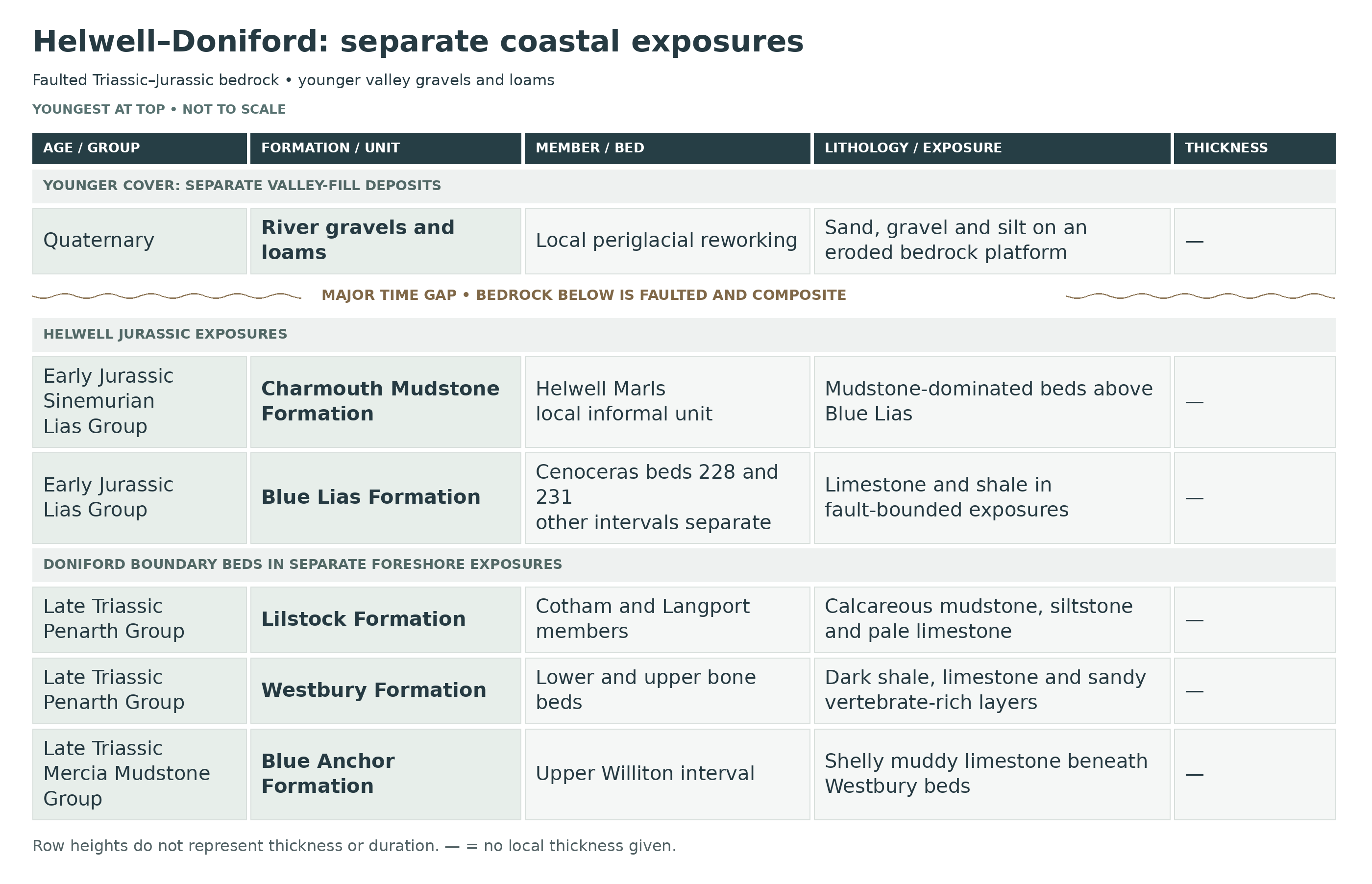
The Jurassic bedrock is exposed in separate fault-bounded sections. Low Hettangian Psiloceras and Caloceras horizons occur on the Doniford foreshore, while higher beds at Helwell include the Cenoceras-rich limestones and mudstone-dominated Helwell Marls. These belong to the Blue Lias and basal Charmouth Mudstone formations respectively. Their juxtaposition is structural, so the shore is not one continuously ascending vertical log.
Overlying the Jurassic and Triassic bedrock are much younger superficial deposits dating from the Pleistocene Ice Age. These deposits form much of the material seen in the cliffs and upper slopes around the bay. They consist mainly of gravels, sands and silts that were laid down by ancient river systems and subsequently modified by cold-climate processes during periods of periglacial activity. Freeze–thaw cycles and mass movement caused these sediments to slump and deform, producing the irregular and unstable cliff sections visible today.
These so-called “glacial” or periglacial deposits are exposed along Helwell Bay towards the Swill, with thickness changing as the underlying rock platform slopes eastwards. Evidence for the investigated late Pleistocene sequence indicates that the British–Irish ice sheet did not cover this coast during MIS3–2, the climate during the Ice Age was severe enough to produce extensive periglacial conditions, which shaped the landscape and reworked earlier sediments.

This is a composite stratigraphic breakdown of Helwell Bay and the adjacent Doniford foreshore, where a heavily faulted uppermost Triassic to lower Jurassic succession is exposed from the upper Blue Anchor Formation through the Penarth Group into the Blue Lias and basal Charmouth Mudstone. The locality is especially important for the paired Rhaetian bone beds at Doniford, the lowest west Somerset psiloceratid succession, and the lower Sinemurian Helwell Marls and Cenoceras beds of the upper foreshore at Helwell Bay.
Earlier HB identifiers were editorial labels rather than published bed numbers. Named horizons and the genuine Whittaker–Green numbers are retained. Page’s broad proposed Black Ven Mudstone Member is not the same unit as the BGS Black Ven Marl Member; the local Helwell Marls are therefore left at their supported informal rank here.
Section Architecture
Helwell Bay and Doniford do not form one simple continuous cliff log. The Rhaetian boundary beds are best seen at very low tide on the Doniford foreshore east of Watchet, whereas Helwell Bay itself exposes much higher Blue Lias and basal Charmouth Mudstone in low cliffs and foreshore platforms north of the railway line and beside the revetment and groynes. Pleistocene gravels and head locally cap or obscure the western cliffline, and modern beach cover can hide large parts of the bedrock for long periods.
Structural Note
This is a faulted composite locality. Rhaetian strata on the Doniford foreshore are folded and heavily faulted; the Doniford Bay Fault brings lower Sinemurian strata down against Mercia Mudstone, and the Helwell Bay Fault throws Blue Lias against Mercia Mudstone farther west. The result is that upper Triassic and lower Jurassic rocks are juxtaposed in short coastal distances, and some intervals are repeated, truncated or concealed. The succession below therefore follows published bed numbers where they exist, but it is not presented as a falsely continuous single face.
MERCIA MUDSTONE GROUP
Blue Anchor Formation (Upper Triassic: Latest Norian–Rhaetian)
Rydon Member
Highest Exposed Rydon Member Mudstones And Siltstones
The highest exposed Blue Anchor strata at Doniford consist of green to dark grey dolomitic mudstones and siltstones with thin laminae, local dolomitized siltstone beds and the evaporitic overprint typical of the upper Mercia Mudstone Group. In regional terms these beds correspond to the Tea Green Marl–Grey Marl interval of older usage, but at Doniford they are seen only in fault slices beneath the Rhaetian marine beds. Their lithology and sparse marine influence indicate a subtidal to supratidal sabkha or ephemeral coastal-flat setting, more marine than the classic red Mercia mudstones below but still markedly restricted.
Williton Member
Williton Member / Sully Beds Equivalent
Immediately beneath the basal Westbury bone bed at Doniford is a thin but distinctive muddy, calcite-cemented limestone bed rich in Rhaetavicula contorta. This is the local expression of the Williton Member, the North Somerset and South Wales transgressive unit formerly called the Sully Beds. Its shell-rich lithology and stratigraphic position record marine influence before the main Westbury transgression; the contact beneath the basal bone bed shows erosion. At Doniford it is much thinner than at some other Somerset sections, but it remains one of the most important indicators that the marine flooding began before the classic basal bone-bed lag was laid down.
PENARTH GROUP
Westbury Formation (Rhaetian)
Lower Bone Bed (c. 5 cm, But Variable)
The lower Doniford bone bed is a black sandy marl with an eroded upper surface and local conglomeratic development where marly limestone intraclasts have been ripped up from below. It is dominated by well-rounded quartz grains, mostly 0.1–2 mm across, with wavy lamination and a thin calcitic matrix; small black and brown abraded bones and teeth are common. The bed rests on a bored and burrowed hardground at the top of the Blue Anchor Formation, and it is best interpreted as the principal lag of the initial Rhaetian transgression. Typical fossils are fish teeth and scales with rarer reptile material, all showing abrasion and reworking. This is one of the classic Somerset basal bone-bed facies.
Intervening Basal Westbury Shales And Limestones (c. 50–60 cm)
Above the lower bone bed lies an interval of black shales, laminated marly limestone and more massive limestone. The beds are pyritic, dark and clearly marine, but they still retain the variable, storm-influenced and restricted character typical of the lower Westbury Formation. Sedimentary structures and lithological contrasts suggest alternating quiet muddy deposition and brief higher-energy events. This short interval is important because it separates the two Doniford bone beds and shows that the upper bed is not simply a reworked residue from the lower one.
Upper Bone Bed (c. 6.5 cm)
The upper bone bed is a black siltstone to fine sandstone with wavy bedding and isolated vertebrate remains. Unlike the lower bone bed it lacks conspicuous intraclasts, contains much less calcite, and its fossils are more sparsely distributed within a finer, darker matrix. Some larger fossils are pyritized, including reported ichthyosaur material. This bed represents a second concentration horizon within the lower Westbury, distinct in both lithology and faunal taphonomy from the lower bone bed, and probably formed during a separate reworking event under restricted shallow-marine conditions.
Main Westbury Shale–Limestone–Beef Succession
Above the upper bone bed the Westbury Formation continues as grey to black laminated pyritic shales, mudstones and fine sandstones with occasional silty or muddy limestones, commonly associated with fibrous calcite “beef”. Ripple marks and trace fossils show that these were deposited in shallow water, but the strongly pyritic, dark character indicates restricted bottom conditions and at least episodic oxygen deficiency. Bivalves, fish debris and shell-rich horizons occur patchily. The overall environment was a shallow marine embayment or shelf-lagoon system with rapid fluctuations in salinity, water depth and oxygenation, probably intensified by storm events.
Lilstock Formation (Rhaetian)
Cotham Member
Basal Contorted Cotham Bed
The base of the Cotham Member at Doniford is marked by a disturbed bed with contorted bedding, long recognized as a laterally traceable deformed unit and commonly interpreted as a seismite. Greenish-grey calcareous mudstones and siltstones are internally disrupted and rest abruptly above the darker Westbury marine beds. This bed records an abrupt change from the open restricted-marine Westbury setting to very shallow brackish Cotham conditions, accompanied by synsedimentary disturbance, dewatering or slump-like deformation.
Lower Cotham Calcareous Mudstones And Siltstones
The lower and middle Cotham succession at Doniford consists of greenish-grey calcareous mudstones and siltstones with occasional argillaceous limestones, the limestone proportion increasing upward. The beds are cyclic and were deposited under very shallow brackish to lagoonal conditions during a prolonged phase of lower relative sea level. Fossils are much sparser than in the Westbury and the facies is more restricted. The rhythmic alternation of mud-rich and carbonate-rich beds shows repeated shifts between quieter water, firmer substrate and short-lived exposure-prone shallows.
Desiccation-Cracked Sandstone / Calcarenite Level
At one level in the Cotham succession a more arenaceous bed occurs, represented by a thin sandstone or calcarenitic horizon with evidence of subaerial exposure, including desiccation cracking. This is one of the clearest indicators that the Doniford Cotham beds were deposited on very shallow flats or lagoon margins that periodically dried out. It marks a brief higher-energy influx within an otherwise mud-dominated restricted succession and is an important environmental marker even where the exact bed geometry is obscured by weathering or faulting.
Alternative Gallois Cotham Upper Interval: Porcellanous Limestones And Burrowed Top
The upper Cotham beds comprise greenish-grey mudstones with laterally variable porcellanous and argillaceous limestones, including pale dense micritic beds comparable to the more conspicuous marker limestones seen farther east at St Audries Bay. The top of Gallois’s Cotham Formation, rather than the BGS Cotham Member, is capped by a strongly bioturbated limestone with abundant burrow systems and hardground development. These features are described in Gallois’s alternative Cotham Formation scheme, which extends above the conventional BGS Cotham Member. In the BGS scheme the C7 porcellanous marker and higher beds lie within the Langport Member. The two sets of boundaries must not be conflated.
Langport Member
Langport White Lias Limestones And Sun Bed
The Langport Member at Doniford is better developed than at some other British boundary sections and consists of light grey laminated micritic limestones with rare calcareous shales. The limestones are dense, pale and splintery, and several are capped by desiccated erosional surfaces showing repeated brief emergence. Corals indicate clearer and more oxic water than in the underlying Cotham or Westbury beds, yet the fauna remains low-diversity and the environment was still highly stressed. The top bed has long been called the “Sun Bed” because of its dried and cracked appearance and is the most distinctive uppermost Penarth marker at the locality.
Upper Marly Langport Interval / Former Watchet Beds (c. 0.5 m Near Watchet)
Above the pale White Lias limestones lies a thin marly interval of grey fissile and locally bituminous calcareous mudstones with occasional silty limestones. Older literature often separated these as the Watchet Beds or Watchet Mudstone, but they are retained here as the upper muddy part of the Langport Member in keeping with current broad usage. Published measurements vary with exposure and boundary scheme; a regional half-metre estimate is not imposed on every Doniford section. It records renewed deepening, greyer marine mud deposition and the first signs of the darker organic-rich facies that become more fully established in the basal Blue Lias.
LIAS GROUP
Blue Lias Formation (Latest Rhaetian To Lower Sinemurian)
Blue Lias Numbering Note
The standard west Somerset bed numbers of Whittaker & Green are retained below where they are well established in the literature. Doniford provides the key basal Hettangian ammonite succession, whereas Helwell Bay exposes much higher Blue Lias and the transition into Charmouth Mudstone facies. The sequence is therefore composite: it uses formal published bed numbers where available, but it follows the beds laterally across foreshore and low cliff sections rather than pretending that Helwell Bay and Doniford form one uninterrupted wall section.
Beds 1–7, Pre-planorbis Beds (c. 5 m)
The basal Blue Lias at Doniford consists of calcareous silty mudstones, laminated “paper shales” and thinner argillaceous micritic limestones. These lowest beds are largely ammonite-barren in the classical sense, though rich in marine bivalves such as Liostrea hisingeri, and they record the first establishment of a more open offshore marine regime above the Penarth boundary facies. The lithology already shows the classic Blue Lias alternation of mudstone and limestone, but the basal interval still carries the latest Rhaetian to earliest Hettangian boundary signature and remains central to discussion of the practical base of the Jurassic in Britain.
Beds 8–9, Lowest Psiloceratid Interval
Bed 8 has yielded the earliest known psiloceratids in the west Somerset coastal succession, including weakly ribbed forms referred to Psiloceras cf. erugatum, while Bed 9 has yielded cf. Neophyllites and very early psiloceratid material. Lithologically these beds are still part of the lower Blue Lias alternation of laminated mudstones and rather nodular limestones, but biostratigraphically they are crucial because they demonstrate that ammonites enter before the main Psiloceras planorbis interval higher in the succession.
Beds 13–19, Main Psiloceras planorbis Interval
These beds contain abundant unequivocal Psiloceras planorbis and form the main lower Hettangian marker interval at Doniford. The rocks remain typical Blue Lias mudstone–limestone alternations, but the ammonite fauna is now well established and provides one of the best regional correlations in the basal Jurassic. Associated fossils include common bivalves and small echinoids; articulated Diademopsis tests and spines are known from beds within this lower Planorbis succession. The interval is fully marine, offshore and low-energy, with periodic limestone formation during pauses in mud accumulation.
Beds 20–24, Upper Planorbis Subzone And Laminated Bed 24
The upper part of the Planorbis succession becomes more mudstone-rich and culminates in the famous Bed 24, more than 2 m of indurated laminated mudstone packed with crushed iridescent ammonites of the Psiloceras planorbis group. The upper part of the bed has also yielded more bluntly ribbed forms referred to Psiloceras ex gr. plicatulum. Bed 24 is one of the most distinctive lower Jurassic fossil beds on the Somerset coast, and it is a leading candidate source for some of the historic nacreous Watchet-area ammonites, though exact old provenance is not always certain. The fine lamination indicates quiet bottom-water conditions with fine-sediment accumulation and limited disturbance.
Beds 25–37, Johnstoni Subzone And Lower Caloceras Interval
Bed 25 marks the first appearance of Caloceras and therefore the base of the Johnstoni Subzone. Through beds 25–37 the Blue Lias continues as alternating mudstones, laminated shales and limestones; Caloceras johnstoni occurs in Bed 36 and C. intermedium in Bed 37. This is a key interval for detailed west Somerset Hettangian subdivision and is one of the horizons that helped establish Doniford as the superior ammonite section to St Audries Bay for the lowermost Jurassic biostratigraphy. Fossils are commonly flattened in the darker mudstones and better preserved in the limestones.
Higher Blue Lias Continuation At Doniford And Helwell Bay
Above the basal Hettangian psiloceratid succession, the Blue Lias continues through many tens of metres of alternating medium- to dark-grey calcareous blocky mudstones, laminated bituminous shales and hard blue-grey limestones. In the wider west Somerset standard section these higher beds span the later Hettangian and pass upward into lower Sinemurian strata, but within the Helwell Bay–Doniford locality they are exposed as faulted slices rather than a single measured continuous run. The faunas diversify upward and include Arnioceras, Coroniceras, Paracoroniceras, oysters and rare vertebrate remains, while the lithology becomes increasingly mudstone-dominated toward the uppermost Blue Lias facies seen at Helwell Bay.
Helwell Bay Upper Blue Lias Beds Below The Main Cenoceras Bed
In Helwell Bay the upper Blue Lias is exposed in low cliff sections and east–west foreshore ledges as gently northward-dipping dark shales, paler grey calcareous mudstones and occasional persistent limestones. The beds immediately below the main nautilid horizon include grey-black shale, blocky grey mudstone and calcareous mudstone, with bioturbation and local uneven limestone tops. They lie in the lower Sinemurian Semicostatum Chronozone and lead up toward the local Lyra Subchronozone ammonite horizons that characterize the Blue Lias–Charmouth transition in west Somerset.
Main Cenoceras Bed (Whittaker & Green Bed 228)
Paul (2018, as dated on the paper’s title page) studied the local nautilid–crinoid association in Palmer’s series E, bed V. He reports the suggested correlation with Whittaker and Green bed 228, but explicitly discusses uncertainty in matching Palmer’s Helwell numbering to that framework. Paul places his horizon in the upper Bucklandi Subzone, whereas Evans and King (2019) assign their BGS 228/231 horizons to the Lyra Subzone. These differing identifications are kept separate. Paul measures his bed at about 0.30 m thick and describes exposed stretches about 160 m and 130 m long on opposite sides of the groynes; these are observations of his study, not additional measurements assigned to the later BGS 228 row. E(V) is therefore retained as an attributed historical comparison, rather than an unconditional second bed label.
This is the most distinctive Helwell Bay bed for lower Sinemurian collectors and palaeoecologists. It is a persistent limestone horizon crowded in places with nautilids referred to Cenoceras, many lying on bedding surfaces and commonly associated with encrusters that formed small shell-supported “islands” above the surrounding sediment. Ammonites are relatively sparse compared with the sheer abundance of nautilids. The bed records a phase of slow sedimentation or localized shell concentration on the sea floor rather than a simple storm lag, and it has become one of the best-known faunal marker beds in the upper Blue Lias of west Somerset.
Intervening Mudstones And Upper Cenoceras Bed (Bed 231; c. 0.7 m Above Bed 228)
About 0.7 m above the Main Cenoceras Bed lies a second nautilid-rich horizon, the Upper Cenoceras Bed. The intervening beds are grey mudstones and calcareous mudstones with minor limestones, and the upper bed is a thinner, impersistent nodular limestone containing fewer nautilids than the Main Cenoceras Bed, according to Evans and King (2019). Together the two beds define a short interval of unusual nautilid dominance within the lower Sinemurian Blue Lias. Their limited thickness range, persistence and strong faunal contrast make them exceptionally useful local markers in the Helwell Bay upper foreshore sequence.
Doniford Shales, Uppermost Blue Lias Transitional Interval
The highest local Blue Lias facies in the Helwell Bay–Doniford area are Palmer’s Doniford Shales, transitional beds between the limestone–mudstone alternations of the Blue Lias below and the more uniform Charmouth Mudstone facies above. They comprise dark shales, paler calcareous mudstones and thin limestones. The highest ammonite fauna in this interval represents Sn15b within the Lyra Subchronozone, and the beds are closely associated with forms such as Coroniceras lyra. They are important because they show that on the west Somerset coast the Blue Lias–Charmouth boundary is relatively complete rather than strongly condensed.
Charmouth Mudstone Formation (Lower Sinemurian)
Helwell Marls: Local Informal Unit
Basal Helwell Marls / Basal Charmouth Mudstone
The basal Charmouth Mudstone at Helwell Bay is represented by Palmer’s Helwell Marls, a local informal unit within the basal Charmouth Mudstone Formation. These beds are dark grey thinly interbedded mudstones and organic-rich mudstones with a few thin muddy limestones or doggers, markedly less rhythmic than the Blue Lias below. The lowest fauna represents Sn16, and low levels in the Helwell Marls have yielded Arnioceras bodleyi. This marks the formal incoming of true Charmouth Mudstone facies on the west Somerset coast.
Higher Helwell Marls
Higher in the Helwell Marls the mudstones remain dark, fissile and marl-rich, with only sparse limestone development. The next fauna upward represents Sn17a and includes early Paracoroniceras together with Arnioceras. These beds continue the lower Sinemurian marine mudstone regime and show that the Blue Lias–Charmouth transition at Helwell Bay is stratigraphically fuller than in many more condensed south-western sections. In practical field terms they form the highest Jurassic mudrocks normally examined at the site.
Separate Quaternary Valley-Fill Succession
River, slope and freeze–thaw deposits overlie an eroded Liassic rock platform. They are separated from the Mesozoic bedrock by a very long gap and are not additional Lias beds. The following historical GCR units are local descriptive beds, not formal formations or members.
Bed 2 — Cobbly Gravels (up to 2.9 m in the historical section)
Poorly sorted gravel contains angular to partly rounded cobbles and boulders, many split by cold-climate processes. Local sand lenses and cross-bedded channel fills record stream reworking.
Bed 3 — Red Sandy Silt (up to 0.3 m)
Fine lamination and dispersed small gravel distinguish this silty layer above the cobbly deposit.
Bed 4 — Buff Silty Loam (up to 0.6 m)
Buff silt includes layers and lenses of angular stones and weakly developed prismatic structure.
Bed 5 — Red Clay-Silt (up to 0.6 m)
Red loam shows stronger prismatic fractures and angular fragments of local Lias rock.
Bed 6 — Brown Loam (up to 0.6 m)
The upper loam is commonly structureless, locally thinly bedded, and contains occasional pebbles; archaeological evidence supports a Holocene component.
The historical GCR beds above describe particular exposures. Basell and colleagues’ 2025 study adds sixteen logs along a 138 m section, distinguishing the Doniford gravel from overlying Swill sediments. Their principal units are described separately below; they are not mechanically equated with the older GCR bed numbers. Older fossils and artefacts can be reworked and do not directly date the enclosing gravel.
2025 Doniford study: a separate, laterally variable unit framework
The study’s numbered units include numerous lettered subdivisions that change between adjacent logs. These are channel fills, lenses and lateral variants, not one continuous vertical stack. Made ground caps the natural succession. The separately mapped Helwell Bay gravel lies farther west and was not included in the detailed Doniford log.
Doniford Member — 2025 study
The Doniford Member forms more than half the logged thickness and extends across the exposure. Quartz, quartz-rich sandstone, cleaved sandstone and fine sandstone or siltstone clasts are consistent with local sources, including Exmoor and river-terrace deposits. Bedding, erosion surfaces and channel forms record river deposition, overprinted to varying degrees by freezing and slope movement.
Doniford DM1 — basal river gravel and finer channel-bar deposits
The base cuts sharply into Lias bedrock. Poorly sorted, commonly clast-supported gravel contains cobbles, mostly no more than about 100 mm across but occasionally reaching 200 mm; imbrication and near-horizontal bedding survive. Finer sand, silt and clay, including clay drapes, are particularly developed in the western logs and alternate with gravel-rich layers. Reworked Lias clay occurs as beds and blocks, locally containing bedded small rock fragments. The paper interprets initial high-energy scour and gravel deposition followed by development of a finer-grained river bar, while strong flows continued nearby. A large angular Lias block may have been moved while frozen. The contact with DM2 is commonly disrupted by frost action.
Doniford DM2 — deeper channel fills with strong frost disturbance
In logs 4–12, weakly bedded, poorly sorted gravel is generally rich in clasts but supported by its matrix; stones around 100 mm are common. Deep channels, larger than those in DM1, can have coarse clast-supported gravel at their bases, upward-fining fills and local lenses of open-framework or inclined, better-sorted gravel. Some clasts carry manganese staining. Frost-shattered stones, involutions and chaotic fabrics show strong subsequent periglacial disturbance. Small organic-rich sandy lumps occur locally near the base. The combination records variable river flow rather than direct deposition by glacier ice.
Doniford DM3 — broad, shallow braided-river channels
Also recorded in logs 4–12, this gravel is clast-rich and matrix-supported, with generally subrounded stones. Sorting remains poor but is better than in DM2. Broad shallow channels, some more than 5 m wide, cut clearly into the underlying deposits; bedding and preferred clast orientations are locally preserved. Some parts are cryoturbated, and two small organic-rich lumps were recorded in one subdivision. The principal depositional interpretation is a braided stream.
Doniford DM4 — solifluction gravel beneath the Swill Member
This compact, indurated matrix-supported gravel directly underlies the Swill Member over much of the exposure. Its coarse-sand, grit and brecciated-mudstone matrix changes from yellow-orange in the east to red in the west. Subrounded stones are mostly chaotically arranged, with occasional weak bedding; no organic remains were observed. It is interpreted as a solifluction deposit subsequently affected by frost disturbance. The upper boundary is conspicuous because grain size and colour change, although cryoturbation locally disrupts it. A small channel was recognised towards the western part of the logged exposure.
Swill Member — 2025 study
The Swill Member is approximately 2 m thick across most of the logged section. Its clay-rich silts contain weakly developed soil horizons interpreted as alluvial palaeosols formed on floodplain flats, locally under low-energy or ponded conditions. A possible wind-blown silt component remains unconfirmed. Iron and carbonate redistribution during soil formation help explain the colours; the study does not attribute them solely to different source rocks.
Swill SM1 — discontinuous lower clayey silt
An orange-brown clayey silt with sand, grit and occasional stones occurs in logs 5–12. It usually grades into SM2 above and is absent from the easternmost logs, where SM2 directly overlies the Doniford Member.
Swill SM2 — carbonate-rich yellow sediment
This comparatively continuous yellow clay-rich sediment grades upward into SM3. Carbonate becomes more conspicuous westwards as pale involutions and nodules, and the contact becomes increasingly disturbed. Pipes of material from higher Swill units locally penetrate SM2 and SM1; these structures must not be mistaken for a simple undisturbed sequence.
Swill SM3 — orange-red soil-forming silt
This clay-rich orange-red silt contains grit and occasional well-rounded, flattened stones, heavily weathered enough to obscure their original rock type. Rootlet traces occur throughout. One fallen block showed a friable, blocky fabric and a shell fragment. SM2 and SM3 recur with lateral changes in appearance and composition; their disturbed western boundaries are interpreted as probably reflecting root activity and other bioturbation.
Swill SM4 — a discontinuous gravel between soil-forming intervals
A platy gravel occurs in eastern logs 1–3 and pinches out between logs 3 and 4. Its subangular stones lie in orange-brown silt, without clear bedding or preferred orientation. It separates the lower soil-forming sediments from SM5–6 above, whose base is sharp in the east. The interpretation is an overbank deposit disturbed by bioturbation or solifluction. Its interruption of soil formation indicates at least two palaeosol episodes. The study relates this gravel interval to Norman’s older b–d subdivision, but this correlation does not make the different schemes interchangeable.
Local Swill SM3a — western gravel lens
A smaller, less clearly defined gravel lens occurs in logs 10–11. It is a separate local feature within the laterally varying Swill sediments, not an additional bed that should be inserted everywhere into the eastern sequence.
Swill SM5 and SM6 — upper eastern clayey silts
Above SM4, yellow-brown silty clay (SM5) grades into orange-brown silty clay (SM6). Both have rootlet traces and small clasts averaging about 20 mm and reaching 40 mm. Road metalling and made ground truncate the top. The upper sediments are disturbed around Log 4 and by drainage pipes between logs 4 and 5, preventing straightforward westward tracing.
Swill SM9 — probable western equivalent of the upper silts
From Log 5 westwards, an orange-brown clayey silt lacks the colour subdivision seen in SM5–6. The authors tentatively correlate SM9 with those two eastern units and suggest that this upper group corresponds to Norman’s Mesolithic-artefact-bearing a interval. Neither the unit correlation nor the artefact association supplies a direct numerical date for every part of the Swill Member.
Helwell Bay Member — separate western exposure
Beyond the detailed Doniford log, higher gravel rests directly on several metres of exposed Lias bedrock. The study distinguishes two mapped areas by altitude, but difficult access prevented detailed logging or dating. The gravel is approximately 0.5–2 m thick, has well-developed frost-disturbance structures, and is overlain by a weak palaeosol about 0.5–1 m thick and made ground. Its highest upper surface is estimated at about 16–17 m OD, whereas the Doniford Member’s upper surface lies around 9–10 m OD. These separate exposures must not be presented as successive beds in one stack.
Luminescence chronology and its limits
The analytically acceptable OSL estimates are 65 ± 5 thousand years for DM1 (sample GL05059), 49 ± 5 thousand years for DM2 (GL05061) and 25 ± 3 thousand years for DM3 (GL05062). Ages are relative to sampling in 2005, with quoted one-standard-deviation uncertainties. Two further DM1 estimates, 50 ± 4 and 45 ± 5 thousand years, failed the dose-recovery test and are treated cautiously. The small sample set, lateral separation and disagreement between DM1 estimates limit precision; the paper gives greatest weight to GL05059 for that basal unit. These dates support Devensian river deposition and subsequent periglacial reworking. They do not directly date the separate western Helwell gravel, every Swill soil horizon, or reworked fossils and artefacts.
The modern study supports cold-climate river and slope processes without local ice-sheet coverage during MIS 3–2.
Depositional Environment
The Helwell Bay–Doniford succession records the late Triassic to early Jurassic marine flooding of the Bristol Channel Basin in exceptional detail. The upper Blue Anchor Formation represents restricted sabkha and coastal-flat sedimentation with increasing marine influence upward, culminating in the Williton Member transgressive shell bed. The Westbury Formation records shallow restricted marine conditions, commonly pyritic and probably at times anoxic, with storm-reworked and transgressive bone-bed lags at its base. The Cotham Member marks very shallow brackish lagoonal to tidal-flat conditions with contorted beds, cyclic lime-mud deposition and local emergence; the Langport Member records clear-water restricted carbonate sedimentation repeatedly interrupted by desiccation, followed by the marlier upper Langport or Watchet facies and renewed deepening. The Blue Lias then records establishment of an open offshore early Jurassic sea with alternating mudstone and limestone, increasingly rich ammonite faunas and locally exceptional nacreous preservation in laminated mudstones. At Helwell Bay the uppermost Blue Lias passes into the more persistent marine mudstones of the Charmouth Mudstone Formation, showing continuation of lower Sinemurian offshore deposition rather than abrupt local omission.
Total Thickness Note
The uppermost Blue Anchor and Penarth boundary succession at Doniford is only a few to several metres thick in any one fault slice, but it preserves a highly detailed Rhaetian transgressive record. Above it, the wider Watchet–Helwell coastal tract represents nearly 205 m of Blue Lias and lower Charmouth Mudstone strata in published composite logs, although at Helwell Bay and Doniford these lower Jurassic beds are exposed only in faulted and partly beach-masked slices rather than as one continuous measurable face.
Separate Blue Anchor Foreshore Log At ST 0770 4355
Whittaker and Green measured this section across foreshore reefs approximately 500 m east of Watchet harbour. The following entries retain their youngest-to-oldest order, local measurements and historical Grey Marl/Tea Green Marl divisions. Those older lithological names are not treated as exact equivalents of the Rydon and Williton members. Units A, B and C are the source’s informal marker intervals; their local thicknesses must not be transferred to the western Watchet cliff or St Audries. Beach cover and faulting mean that the full historical measurement is not necessarily visible on a visit.
MERCIA MUDSTONE GROUP
Blue Anchor Formation
Historical source division: Grey Marl
Marl (0.28 m)
Marl, greenish grey, silty, hard and blocky.
Shale and shaly marl (0.81 m)
Shale and shaly marl, greyish green, blocky near the top.
Marl (1.07 m)
Marl, greenish grey, shaly, becoming silty and hard in top 0.13 to 0.15 m.
Siltstones and silty marls (1.14 m)
Siltstones and silty marls, greenish grey, with a thin shaly band near the base.
Partly obscured interval (3.05 m)
Strata mainly obscured, but 0.01 m of dark grey marl is present at the top and greyish green marls are present at the base.
Marl (0.69 m)
Marl, greenish grey, shaly and hard.
Unit C — alternating marls (3.58 m)
Unit C: Marls, dark grey, fine-grained and blocky, alternating with grey marls, each band up to 0.30 m thick except for the topmost dark band which is about 0.91 m thick.
Marls (0.13 m)
Marls, greyish green and grey, silty and hard, with a 0.03-m soft grey marl band in the middle.
Marl (0.48 m)
Marl, greyish green.
Marl (0.66 m)
Marl, dark greyish green, shaly and with laminated silty mudstone.
Marls (1.75 m)
Marls, alternating dark grey and pale greenish buff, with hard greenish grey siltstone in the middle.
Marl (0.66 m)
Marl, greenish grey, hard and silty, alternating with soft grey and dark grey marl.
Marl (1.85 m)
Marl, greenish grey, hard and with intercalations of dark grey marl except in lowest 0.25 m.
Unit B — alternating marls (6.25 m)
Unit B: Marl, alternately green and dark grey, hard, with each bed 0.10 to 0.15 m thick; rather disturbed appearance.
Marl (1.83 m)
Marl, in alternating green and dark grey bands up to 0.23 m thick.
Siltstone (0.15 m)
Siltstone, dark greenish grey, laminated, hard.
Marl (0.38 m)
Marl, grey, soft.
Siltstone (0.23 m)
Siltstone, grey, hard and poorly laminated; marly near the top.
Unit A — green marl with red band (1.04 m)
Unit A: Marl, green, with a 0.03 to 0.05-m red band 0.30 m above the base.
Marl (0.20 m)
Marl, greyish green, silty, with a 0.08-m laminated band at the top.
Marl (0.43 m)
Marl, grey and green, laminated, silty in places.
Marl (0.20–0.30 m)
Marl, greyish green, silty, hard and laminated.
Marls (1.80 m)
Marls, green, with a few dark grey bands.
Marls (0.76 m)
Marls, alternating greyish green and dark grey bands up to 0.10 m thick.
Marl (0.38 m)
Marl, greyish green, hard.
Marl (0.08–0.10 m)
Marl, dark grey.
Historical source division: Tea Green Marl
Marl (0.15 m)
Marl, greyish green, hard and laminated.
Marl (0.48 m)
Marl, pale green, soft.
Marl (1.27 m)
Marl, pale green, silty and hard in top 0.08 m.
Marl (0.05 m)
Marl, greyish green, hard, silty and flat-bedded with ?trace fossils.
Marl (0.51 m)
Marl, green, soft except in lowest 0.08 m.
Marl (1.32 m)
Marl, pale green, soft.
Marl (0.05 m)
Marl, greyish green, hard and silty.
Marl (0.15 m)
Marl, pale green, soft.
Marl (0.15 m)
Marl, pale green, hard and silty.
Marl (1.32 m)
Marl, grey and green, shaly.
Marl (0.08 m)
Marl, pale green, hard.
Marl (0.38 m)
Marl, dark green.
Penarth: Westbury Foreshore At ST 0765 4362
The BGS measured this Westbury section near Helwell Bay just east of Watchet harbour. Thicknesses of broader shale outcrops were calculated from dip and outcrop width, so small errors are possible. Entries follow the source from youngest to oldest. Bed numbers, ranges and unnumbered sub-beds are kept distinct. Fossil names and zone labels are historical identifications as published, not a new taxonomic revision. Thicknesses are local measurements or estimates, not present-day exposure guarantees.
PENARTH GROUP
Westbury Formation
Published bed 5a — Shale (0.08–0.10 m)
This shale interval is dark grey to black.
Limestone (0–0.30 m)
This limestone interval is dark grey, lenticular and locally with ‘beef’ at the top.
Shale (1.22–1.52 m)
This shale interval is dark grey, with thin (0.3 m) sandy limestone bands near the top.
‘Beef’ (0.03 m)
A fibrous-calcite seam is recorded.
Limestone (0.10 m)
This limestone interval is dark and earthy.
‘Beef’ (0.03 m)
A fibrous-calcite seam is recorded.
Shale (0.71 m)
This shale interval is dark grey.
Published bed 5b — ‘Beef’ (0.03–0.05 m)
A fibrous-calcite seam is recorded.
Limestone (0.10 m)
This limestone interval is dark grey and earthy.
Published bed 6–7 — Shale (0.03 m)
This shale interval is dark grey.
Limestone (0.05–0.13 m)
This limestone interval is dark grey, earthy and lenticular. A bone bed is present locally near the top.
‘Beef’ (0.03–0.05 m)
A fibrous-calcite seam is recorded.
Published bed 8 — Shale (1.60 m)
This shale interval is dark grey.
Published bed 9 — Limestone (0–0.30 m)
This limestone interval is dark grey, earthy, hard and very nodular, with up to 0.05 m of dark grey sandy mudstone.
Published bed 10–12 — Shale (3.11 m)
This shale interval is dark grey to black.
‘Beef’ (0.03 m)
A fibrous-calcite seam is recorded.
Published bed 13 — Limestone (0.03 m)
This limestone interval is dark grey, earthy, with shells.
Published bed 14 — Mudstone (0.38 m)
This mudstone interval is dark grey, shaly.
Published bed 15 — Sandstone (0.03 m)
This sandstone interval is dark grey. Bone bed.
Limestone (0.05–0.10 m)
This limestone interval is dark grey, earthy, with shells.
Published bed 16 — Shale (0.76 m)
This shale interval is dark grey.
Published bed 17 — Marl (0.03 m)
This marl interval is dark grey, calcareous, very hard.
Sandstone (0.01 m)
This sandstone interval is dark grey, with bones.
Limestone (0.03–0.05 m)
This limestone interval is dark grey, earthy and pyritic, with shells on the top surface.
Published bed 18 — Shale (0.33–0.38 m)
This shale interval is dark grey, with green wisps and partings.
Published bed 19–25 — Limestone (0.03 m)
This limestone interval is dark grey, shaly and arenaceous.
Limestone (0.03 m)
This limestone interval is dark grey, earthy and sandy.
Shale (0.13 m)
This shale interval is dark grey.
Limestone (0.15–0.36 m)
This limestone interval is dark grey, earthy, lenticular, locally with 0.01 m ‘beef’ at the top.
Published bed 26 — Shale (2.51 m)
This shale interval is dark grey to black.
Published bed 27 — Sandstone (0.03 m)
This sandstone interval is dark grey, medium-grained, with pyrite, some calcite and gypsum.
Limestone (0–0.03 m)
This limestone interval is dark grey, nodular.
Published bed 28 — Shale (0.25 m)
This shale interval is dark grey.
Published bed 29 — Sandstone or sandy shale (0.05 m)
Sandstone or sandy shale, dark grey, with sandstone pebbles.
Shale (0.08 m)
This shale interval is dark grey, with fragments of sandstone.
Sandstone (0.03 m)
This sandstone interval is dark grey, pyritic.
Mudstone (0.03 m)
This mudstone interval is dark grey, shaly, with green laminae and patches.
Sandstone (0.03 m)
This sandstone interval is dark grey, with pyrite.
Published bed 30 — Mudstone (0.13 m)
This mudstone interval is dark grey, shaly, with green laminae and patches.
Sandstone (0.08 m)
This sandstone interval is dark grey and pyritic, with polygonal infillings on the top surface.
Mudstone (0.18–0.20 m)
This mudstone interval is dark grey, shaly, with green wisps and partings.
Published bed 31 — Sandstone (0.05–0.08 m)
This sandstone interval is dark grey, hard, with much pyrite.
Limestone (0.18–0.30 m)
This limestone interval is grey, hard, fine-grained and splintery, with bones and teeth.
Penarth Foreshore Reefs At ST 0827 4345
This separate Doniford foreshore section uses Richardson’s St Audries bed numbering with the BGS change that his Cotham Bed 1 lies in the Langport Member. Entries follow the source from youngest to oldest. Bed numbers, ranges and unnumbered sub-beds are kept distinct. Fossil names and zone labels are historical identifications as published, not a new taxonomic revision. Thicknesses are local measurements or estimates, not present-day exposure guarantees.
PENARTH GROUP
Lilstock Formation
Langport Member
Mudstone (0.36 m)
This mudstone interval is greenish grey, with lenticular limestones.
Published bed 1 — Limestone (0.10 m)
This limestone interval is pale brownish grey, fine-grained and with a slightly irregular top.
Published bed 2 — Limestone (0.10 m)
This limestone interval is pale brownish grey, fine-grained.
Published bed 3 — Limestone (0.13 m)
This limestone interval is pale brownish grey, coarse-grained and crystalline in places; locally Shelly.
Published bed 4 — Mudstone (0.28 m)
This mudstone interval is grey, blocky and non-fissile.
Published bed 5 — Limestone (0.08 m)
This limestone interval is grey, slightly silty, persistent and unfossiliferous.
Published bed 6 — Mudstone (0.03 m)
The recorded interval consists of mudstone.
Limestone (0.10–0.15 m)
This limestone interval is grey, silty, in places lenticular.
Mudstone (0.13 m)
This mudstone interval is grey, silty and marly.
Published bed 7 — Limestone (0.03–0.05 m)
This limestone interval is medium to pale brownish grey, fairly fine-grained; some shells in places.
Published bed 8–11 — Limestone (0–0.10 m)
This limestone interval is dark grey and brownish grey, very fine-grained and rather porcellanous. Lenticular. Laminated appearance in places.
Lilstock Formation
Cotham Member
Published bed 2 — Mudstone (0.48–0.51 m)
This mudstone interval is greenish grey, slightly fissile and with irregular lenticular masses (up to 0.10 m thick) of greenish grey hard laminated limestone; the latter are most abundant in the lowest 0.03 m.
Published bed 3 — Limestones (0.36 m)
Limestones, greenish grey and lenticular, very fine-grained in places and faintly laminated, and green fine-grained shaly marls. Some of the lenticles are green. Medium-grained spotted sandstones are present near the base.
Published bed 4 — Siltstone (0.25–0.48 m)
This siltstone interval is greenish grey, hard and calcareous. Strongly ripple-marked upper surface. Shows contortions of bedding. In the lowest part are partings and wisps of green marl. The bed is variable in thickness and commonly projects down very abruptly into the underlying Westbury Formation. Cardinia cf. regularis, Chlamys valoniensis, Dimyopsis intusstriatus, Eotrapezium concentricum, ‘Gervillia‘ praecursor, Placunopsis alpina?, Protocardia rhaetica and Tutcheria cloacina.
Mudstone (0–0.05 m)
This mudstone interval is green, marly.
Westbury Formation (see (Figure 11) )
Published bed 5a — ‘Beef’ (0–0.50 m)
A fibrous-calcite seam is recorded, not everywhere present but usually developed where the overlying bed projects down.
Limestones (0.20–0.30 m)
Limestones, dark grey, medium-grained, lenticular and nodular; in places with interbedded black and greenish grey shales and marls.
Shales (0.15–0.30 m)
This shales interval is black. E. concentricum, Modiolus sp., P. rhaetica and Rhaetavicula contorta.
Black Shale And Thin Earthy Limestone Alternations (0.30 m)
Black shales alternating with thin (up to 0.05 m) dark grey earthy limestones.
Shale (0.58–0.61 m)
This shale interval is black, with lenticles (0.50 m thick) of dark grey earthy limestone 0.05 m above base. Ophiolepis sp., E. concentricum, E. elongatus, ‘G.‘ praecursor, Lyriomyophoria postera, Modiolus sodburiensis, P. alpina, R. contorta, T. cloacina and ‘Natica‘ oppelii.
‘Beef’ (0.03 m)
A fibrous-calcite seam is recorded.
Limestone (0.10 m)
This limestone interval is dark grey, argillaceous, in places with ‘beef’ at base.
Shale (0.55 m)
This shale interval is black.
‘Beef’ (0.05–0.08 m)
A fibrous-calcite seam is recorded.
Published bed 5b — Limestone (0.20 m)
This limestone interval is very dark grey, argillaceous, with some partings and wisps of black shale.
Published bed 6 — Limestone (0.18–0.20 m)
This limestone interval is dark grey, earthy, massive and hard.
Published bed 7 — Limestone (0.13 m)
This limestone interval is dark grey, earthy, with partings of black shale; lenticular in places along the strike.
Published bed 8 — Shale (0.81 m)
This shale interval is black.
Limestone (0–0.03 m)
This limestone interval is dark grey, earthy and Shelly; not everywhere present.
‘Beef’ (0–0.03 m)
A fibrous-calcite seam is recorded, not everywhere present.
Shale (0.78 m)
This shale interval is black. E. concentricum, P. alpina, ‘Pleurophorus‘ elongatus, Pr. rhaetica, R. contorta, T. cloacina and fish fragments.
Published bed 9 — Limestone (0.08–0.25 m)
This limestone interval is very dark grey, earthy, nodular. C. valoniensis, P. alpina and R. contorta.
Published bed 10–12 — Shale (2.84 m)
This shale interval is black. Poorly exposed and possibly faulted. Cardinia sp., Eotrapezium sp., Lyriomyophoria postera, Modiolus cf. hillanus, Modiolus sp.,’Pleurophorus‘ elongatus, Protocardia rhaetica, R. contorta, T. cloacina, ‘N.‘ oppelii and fish fragments.
‘Beef’ (0–0.03 m)
A fibrous-calcite seam is recorded.
Published bed 13 — Limestone (0.05–0.08 m)
This limestone interval is dark grey, earthy, with pyritised shells including ‘P.‘ elongatus.
Published bed 14 — Shale (0.38 m)
This shale interval is black, Modiolus sp., Pr. rhaetica and R. contorta.
Published bed 15 — Limestone (0.03–0.05 m)
This limestone interval is dark grey, earthy and sandy. Bone bed.
Published bed 16 — Shale (0.58 m)
This shale interval is black. Eotrapezium sp., Lyriomyophoria postera, R. contorta and ‘N.‘ oppelii.
Published bed 17 — Sandstone (0.03–0.05 m)
This sandstone interval is grey, gritty, with fine-grained limestone pebbles. Much pyrite, especially in joints: Eotrapezium sp. nov.?, Modiolus? and Rhaetavicula?. Abundant fish remains include Gyrolepis alberti and Hybodus minor.
Published bed 18–25 — Shale (0.20 m)
This shale interval is black.
Shales (0.03 m)
This shales interval is very dark grey, with hard greenish grey siltstone laminae; irregular top surface.
Shale (0.18 m)
This shale interval is black, with rare green siltstone laminae.
Siltstone and shale (0.03 m)
Siltstone and shale, as penultimate above.
Shale (0.08–0.15 m)
This shale interval is black.
Limestone (0.18–0.30 m)
This limestone interval is grey, fine-grained with some shells; coarser grained in places; a persistent bed. ‘Pleurophorus‘sp., Pteromya cf. crowcombeia, Acrodus minimus, G. alberti and fish fragments.
Published bed 26 — Shale (2.65 m)
This shale interval is black, C. valoniensis, E. concentricum, Lyriomyophoria?, M. sodburiensis, Modiolus sp., P. alpina, Pr. rhaetica, R. contorta; ‘N.‘ oppelii, A. minimus, G. alberti and other fish fragments.
‘Beef’ (0–0.03 m)
A fibrous-calcite seam is recorded.
Published bed 27 — Limestone (0.05–0.10 m)
This limestone interval is dark grey, earthy and shelly. Indet. bivalves and A. minimus.
Published bed 28–30 — Shale (0.25 m)
This shale interval is black. C. valoniensis, Eotrapezium sp., P. rhaetica, R. contorta and fish fragments.
Shale (0.46 m)
This shale interval is black, with two hard green shaly calcareous siltstone bands.
Limestone (0.05 m)
This limestone interval is grey, fairly coarse-grained and Shelly; some green marl present and much pyrite. Eotrapezium? and Liostrea?.
Shale (0.25 m)
This shale interval is black. Eotrapezium sp.,’G.‘ praecursor, Modiolus sp., R. contorta, T. cloacina and fish fragments.
Limestone (0.18–0.20 m)
This limestone interval is grey, medium-grained, hard; base not seen.
Jurassic Offshore Reefs North Of The Doniford Bay Fault
This exact-local reef log north of the fault at ST 0870 4355 records beds dipping north-north-east. It must not be merged into the southern foreshore or cliff sections. Historical zones are retained as source labels; current formation membership is shown separately. Entries follow the source from youngest to oldest. Bed numbers, ranges and unnumbered sub-beds are kept distinct. Fossil names and zone labels are historical identifications as published, not a new taxonomic revision. Thicknesses are local measurements or estimates, not present-day exposure guarantees.
LIAS GROUP
Blue Lias Formation
Historical source division: Arietites bucklandi Zone, conybeari Subzone Bed No.
Blue Lias Formation
Published bed 158 — Shale (0.46 m)
Shale. Abundant Vermiceras sp. In the lists that follow, generic names given alone are field identifications; where sp. or a trivial name has been added material was collected or it was recorded and identified from photographs.
Published bed 157 — Limestone (0.15–0.23 m)
The recorded interval consists of limestone.
Published bed 156 — Shale and mudstone (0.30 m)
Shale and mudstone. ‘Chondrites‘.
Published bed 155 — Limestone (0.28 m)
The recorded interval consists of limestone.
Published bed 154 — Shale with thin mudstone near base (2.17 m)
Shale with thin mudstone near base. Vermiceras sp.
Published bed 153 — Limestone (0.19 m)
The recorded interval consists of limestone.
Published bed 152 — Shale and mudstone (0.58 m)
Shale and mudstone. ‘Chondrites‘.
Published bed 151 — Limestone (0.03–0.13 m)
This limestone interval is very nodular and lenticular.
Published bed 150 — Mudstone (0.46 m)
The recorded interval consists of mudstone.
Published bed 149 — Limestone (0.30 m)
This limestone interval is massive and persistent.
Published bed 148 — Shale and mudstone (0.58 m)
Shale and mudstone, dark grey.
Published bed 147 — Limestone in three bands separated by mudstone (0.91 m)
Limestone in three bands separated by mudstone.
Mudstone (0.05 m)
The recorded interval consists of mudstone.
Limestone (0–0.10 m)
This limestone interval is nodular and lenticular.
Published bed 146 — Shale (0.83 m)
Shale. Vermiceras solaroides.
Historical source division: Schlotheimia angulata Zone
Published bed 145 — Shale (1.45 m)
Shale. Schlotheimia.
Published bed 144 — Limestone nodules (0–0.23 m)
Limestone nodules.
Published bed 143 — Shale (0.66 m)
The recorded interval consists of shale.
Published bed 142 — Limestone (0.38 m)
This limestone interval is massive.
Published bed 141 — Shale (0.46 m)
This shale interval is calcareous mudstone near top.
Published bed 140 — Limestone (0.23 m)
The recorded interval consists of limestone.
Published bed 139 — Shale (1.69 m)
This shale interval is mudstone at base.
Published bed 138 — Limestone (0.03–0.08 m)
This limestone interval is lenticular.
Mudstone (0.23 m)
The recorded interval consists of mudstone.
Limestone (0.20 m)
The recorded interval consists of limestone.
Published bed 137 — Shale (2.53 m)
The recorded interval consists of shale.
Mudstone (0.08 m)
Mudstone. Schlotheimia.
Published bed 136 — Limestone (0.30 m)
This limestone interval is massive and persistent. Schlotheimia angulata.
Published bed 135 — Shale (0.46 m)
Shale. Abundant Schlotheimia.
Published bed 134 — Limestone (0.05–0.08 m)
This limestone interval is somewhat lenticular. Gryphaea arcuata.
Mudstone (0.05–0.08 m)
The recorded interval consists of mudstone.
Limestone (0.18 m)
The recorded interval consists of limestone.
Published bed 133 — Mudstone (0.20 m)
Mudstone. ‘Chondrites‘.
Published bed 132 — Limestone (0.18–0.23 m)
The recorded interval consists of limestone.
Published bed 131 — Mudstone (0.20 m)
The recorded interval consists of mudstone.
Published bed 130 — Limestone (0.20 m)
The recorded interval consists of limestone.
Published bed 129 — Shale (1.55 m)
Shale. S. angulata.
Mudstone (0.36 m)
This mudstone interval is calcareous, with two impersistent nodule beds. Calcirhynchia calcaria.
Published bed 128 — Limestone (0.23 m)
This limestone interval is massive and persistent.
Published bed 127 — Mudstone (1.01 m)
The recorded interval consists of mudstone.
Published bed 126 — Limestone (0.30 m)
This limestone interval is massive and persistent.
Published bed 124–125 — Mudstone (3.16 m)
This mudstone interval is shaly.
Published bed 123 — Limestone (0.10–0.13 m)
This limestone interval is nodular top. Schlotheimia.
Published bed 122 — Mudstone (0.05 m)
The recorded interval consists of mudstone.
Published bed 121 — Limestone (0.23 m)
This limestone interval is massive and persistent.
Published bed 120 — Mudstone (0.30 m)
This mudstone interval is calcareous.
Published bed 119 — Limestone (0.13 m)
The recorded interval consists of limestone.
Published bed 118 — Mudstone (0.10 m)
The recorded interval consists of mudstone.
Published bed 117 — Limestone (0.25 m)
This limestone interval is persistent. Schlotheimia.
Published bed 115–116 — Shale and mudstone (3.16 m)
Shale and mudstone.
Published bed 114 — Limestone (0.18 m)
This limestone interval is massive and persistent.
Published bed 112–113 — Mudstone (0.33 m)
This mudstone interval is calcareous, passing laterally into nodular limestone.
Published bed 111 — Limestone (0.15 m)
This limestone interval is persistent. S. angulata and C. calcaria.
Published bed 110 — Mudstone (0.03 m)
This mudstone interval is calcareous. S. angulata and C. calcaria.
Published bed 109 — Limestone (0.18 m)
This limestone interval is massive and persistent.
Published bed 108 — Mudstone (0.15 m)
The recorded interval consists of mudstone.
Published bed 107 — Limestone (0.10–0.15 m)
This limestone interval is lenticular.
Published bed 106 — Shale and calcareous mudstone (1.14 m)
Shale and calcareous mudstone.
Published bed 105 — Limestone (0.10–0.13 m)
This limestone interval is persistent.
Published bed 104 — Mudstone (0.13 m)
The recorded interval consists of mudstone.
Published bed 103 — Limestone (0.23 m)
This limestone interval is persistent.
Published bed 102 — Mudstone (1.30 m)
This mudstone interval is shaly.
Published bed 101 — Limestone (0.13–0.15 m)
This limestone interval is persistent.
Mudstone (0.05 m)
The recorded interval consists of mudstone.
Limestone (0.10–0.15 m)
This limestone interval is rather nodular.
Published bed 100 — Mudstone (0.38 m)
The recorded interval consists of mudstone.
Published bed 98–99 — Limestone (0.08–0.15 m)
This limestone interval is rather lenticular.
Mudstone with two nodular limestone horizons (1.49 m)
Mudstone with two nodular limestone horizons.
Published bed 97 — Limestone with nodular top (0.15 m)
Limestone with nodular top.
Published bed 93–96 — Mudstone with several nodular limestone horizons (1.46 m)
Mudstone with several nodular limestone horizons. Schlotheimia.
Published bed 92 — Mudstone (1.66 m)
This mudstone interval is with two nodular limestone horizons.
Published bed 91 — Limestone (0–0.13 m)
This limestone interval is lenticular.
Mudstone (0.05 m)
The recorded interval consists of mudstone.
Limestone (0–0.13 m)
This limestone interval is nodular.
Published bed 90 — Mudstone (1.34 m)
This mudstone interval is shaly.
Published bed 89 — Limestone (0–0.08 m)
This limestone interval is nodular.
Mudstones with a limestone band (0.36 m)
Mudstones with a limestone band.
Limestone (0–0.05 m)
This limestone interval is nodular.
Mudstone (0.55 m)
This mudstone interval is shaly.
Limestone (0.03–0.08 m)
This limestone interval is platy and flat. Schlotheimia.
Mudstone (0.64 m)
This mudstone interval is shaly.
Limestone (0.08 m)
This limestone interval is flat-topped and platy.
Published bed 88 — Mudstone (1.46 m)
This mudstone interval is shaly.
Published bed 87 — Limestone in three nodular bands with mudstones between (0.76 m)
Limestone in three nodular bands with mudstones between.
Mudstone (0.25 m)
The recorded interval consists of mudstone.
Limestone (0.08–0.13 m)
This limestone interval is persistent.
Published bed 86 — Mudstone (0.53 m)
This mudstone interval is shaly.
Published bed 85 — Limestone (0.13 m)
The recorded interval consists of limestone.
Mudstone (0.15 m)
The recorded interval consists of mudstone.
Limestone (0–0.08 m)
This limestone interval is lenticular.
Published bed 84 — Mudstone (1.02 m)
The recorded interval consists of mudstone.
Published bed 83 — Limestone (0.15 m)
This limestone interval is nodular in places.
Published bed 80–82 — Mudstone (2.66 m)
This mudstone interval is shaly, calcareous near base. Schlotheimia amblygonia.
Historical source division: Alsatites liasicus Zone
Published bed 79 — Limestones (0.86 m)
Limestones, very nodular, up to six bands, with thin mudstone partings between.
Mudstone (0.46 m)
The recorded interval consists of mudstone.
Limestone (0.10–0.13 m)
This limestone interval is very nodular top.
Mudstone with nodular limestone near middle (0.53 m)
Mudstone with nodular limestone near middle.
Limestone (0–0.13 m)
This limestone interval is lenticular in places.
Mudstone (0.46 m)
This mudstone interval is calcareous.
Limestone (0.08–0.13 m)
The recorded interval consists of limestone.
Published bed 78 — Mudstone with a nodular limestone (1.07 m)
Mudstone with a nodular limestone.
Mudstones with two limestone bands (1.21 m)
Mudstones with two limestone bands.
Published bed 77 — Limestone (0–0.15 m)
This limestone interval is nodular.
Published bed 76 — Mudstone (1.74 m)
This mudstone interval is shaly. Caloceras cf. bloomfieldense, C. leptoptychum and Waehneroceras sp.
Published bed 75 — Limestones in two very nodular bands separated by mudstone (0.41 m)
Limestones in two very nodular bands separated by mudstone.
Published bed 74 — Shale and mudstone (1.42 m)
Shale and mudstone. Alsatites?, Laqueoceras?, Psilophyllites sp. and Waehneroceras sp.
Published bed 73 — Limestones in two nodular bands separated by mudstone (0.34 m)
Limestones in two nodular bands separated by mudstone.
Published bed 72 — Mudstone (0.91 m)
This mudstone interval is shaly.
Published bed 71 — Limestone (0–0.10 m)
This limestone interval is lenticular and nodular.
Published bed 70 — Mudstone (0.30 m)
This mudstone interval is grey.
Published bed 69 — Limestone (0.18 m)
This limestone interval is persistent.
Published bed 68 — Mudstone (0.89 m)
The recorded interval consists of mudstone.
Published bed 67 — Shale (2.19 m)
Shale. Laqueoceras sublaqueus and Waehneroceras sp.
Published bed 64–66 — Mudstone in two bands separated by a 0.08 m limestone (3.72 m)
Mudstone in two bands separated by a 0.08-m persistent limestone.
Published bed 63 — Shale (0.23 m)
Shale. Waehneroceras.
Published bed 62 — Mudstone (0.63 m)
The recorded interval consists of mudstone.
Published bed 61 — Shale (0.61 m)
Shale. Psilophyllites and Waehneroceras.
Published bed 58–60 — Mudstone and shale (1.90 m)
Mudstone and shale.
Published bed 57 — Shale (1.36 m)
Shale. Waehneroceras.
Published bed 54–56 — Mudstone (2.19 m)
This mudstone interval is with darker bands and a persistent line of limestone nodules near the top.
Published bed 51–53 — Shale and mudstone (1.72 m)
Shale and mudstone.
Published bed 49–50 — Mudstone with a persistent line of limestone nodules near the base (3.08 m)
Mudstone with a persistent line of limestone nodules near the base.
Published bed 45–48 — Shale and mudstone alternating (3.82 m)
Shale and mudstone alternating.
Published bed 44 — Shale (0.15 m)
Shale. Waehneroceras.
Published bed 43 — Mudstone (2.24 m)
Mudstone. Schlotheimids.
Historical source division: Psiloceras planorbis Zone
Published bed 42 — Limestone (0–0.10 m)
This limestone interval is very nodular.
Published bed 41 — Mudstone (0.05–0.08 m)
The recorded interval consists of mudstone.
Published bed 40 — Limestone (0.08–0.10 m)
This limestone interval is rather persistent.
Published bed 39 — Mudstone (0.15 m)
The recorded interval consists of mudstone.
Published bed 38 — Limestone (0–0.10 m)
This limestone interval is nodular.
Published bed 36–37 — Shale with mudstone at the top (1.12 m)
Shale with mudstone at the top. Abundant Caloceras intermedium and C. johnstoni.
Published bed 33–35 — Two limestone bands with 0.74 m of mudstone between (0.97 m)
Limestone in two bands with 0.74 m of mudstone between.
Published bed 32 — Shale and mudstone (0.38 m)
Shale and mudstone.
Published bed 29–31 — Limestones with Caloceras (0.96 m)
Limestones with Caloceras, in two bands with mudstone between.
Published bed 28 — Mudstone (0.03–0.15 m)
The recorded interval consists of mudstone.
Published bed 27 — Limestone (0.15–0.20 m)
This limestone interval is very rubbly and with a nodular top.
Published bed 26 — Mudstone (0.30 m)
The recorded interval consists of mudstone.
Published bed 25 — Limestone (0.13–0.15 m)
This limestone interval is rather nodular.
Published bed 24 — Shale and mudstone (2.71 m)
Shale and mudstone. Abundant Psiloceras planorbis.
Published bed 23 — Mudstone (0.15 m)
The recorded interval consists of mudstone.
Published bed 22 — Limestone (0.05–0.08 m)
Limestone. Protocardia cf. philippiana, Pteromya tatei and echinoid fragments.
Published bed 19–21 — Mudstones in two bands separated by limestone (0.34 m)
Mudstones in two bands separated by limestone.
Published bed 18 — Shale (0.38 m)
Shale. P. planorbis.
Published bed 15–17 — Mudstones in two bands separated by massive limestone (0.66 m)
Mudstones in two bands separated by massive limestone.
Published bed 14 — Shale (0.30 m)
Shale. P. planorbis.
Historical source division: Pre-planorbis Beds (Triassic)
Published bed 13 — Mudstone (0.33 m)
The recorded interval consists of mudstone.
Published bed 10–12 — Limestones in two bands separated by shaly mudstone (0.35 m)
Limestones in two bands separated by shaly mudstone.
Published bed 9 — Shale and mudstone with some limestone nodules (0.33 m)
Shale and mudstone with some limestone nodules.
Published bed 8 — Limestone (0.15 m)
The recorded interval consists of limestone.
Published bed 7 — Shale and mudstone (1.60 m)
Shale and mudstone.
Published bed 6 — Limestone with two shale partings (0.71 m)
Limestone with two shale partings.
Published bed 2–5 — Strata obscured by sand and mud (2.55 m)
Strata obscured by sand and mud.
Mudstone (0.13 m)
This mudstone interval is shaly and calcareous.
Published bed 1 — Shale (1.42 m)
The recorded interval consists of shale.
Jurassic Foreshore South Of The Doniford Bay Fault
This measured foreshore section south of the fault covers the higher shale-rich Jurassic interval. The nearby cliff locality is ST 0783 4325; these are separate from the lower reef section. Entries follow the source from youngest to oldest. Bed numbers, ranges and unnumbered sub-beds are kept distinct. Fossil names and zone labels are historical identifications as published, not a new taxonomic revision. Thicknesses are local measurements or estimates, not present-day exposure guarantees.
LIAS GROUP
Blue Lias Formation
Historical source division: Arnioceras semicostatum Zone
Charmouth Mudstone Formation
Published bed 252 — Shale (Seen 4.27 m)
This shale interval is partly bituminous.
Published bed 251 — Shale; small oblique faults cross the beds (3.54 m)
Shale; small oblique faults cross the beds.
Published bed 250 — Limestone (0–0.10 m)
This limestone interval is nodules or hard calcareous mudstone.
Published bed 249 — Shale (2.77 m)
Shale. Arnioceras cf. bodleyi and A. cf. semicostatum.
Published bed 248 — Shale (2.92 m)
Shale. A. cf. bodleyi.
Published bed 247 — Limestone (0.05–0.15 m)
This limestone interval is nodular. Coroniceras lyra, C. subrotiforme and C. (Paracoroniceras) charlesi.
Published bed 243–246 — Shale with a 0.05 m calcareous-mudstone band (6.68 m)
Shale with a 0.05 m nodular band of calcareous mudstone at 2.23 m below the top. C. subrotiforme and C. (P.) charlesi.
Published bed 242 — Limestone (0.13 m)
This limestone interval is well jointed.
Published bed 239–241 — Shale (8.15 m)
Shale. A. cf. bodleyi, A. cf. miserabile, C. (P.) charlesi and Sulciferites sp.
Blue Lias Formation
Published bed 238 — Limestone (0.18 m)
This limestone interval is rather poorly jointed.
Published bed 236–237 — Shale (3.36 m)
Shale. A. bodleyi.
Published bed 235 — Limestone (0.03–0.41 m)
This limestone interval is persistent but poorly jointed.
Published bed 228–234 — Mudstone (0.51 m)
Mudstone. Arnioceras sp.
Shale (0.97 m)
The recorded interval consists of shale.
Mudstone (0.20 m)
The recorded interval consists of mudstone.
Limestone or hard calcareous mudstone (0.15–0.25 m)
Limestone or hard calcareous mudstone.
Shale (0.23 m)
The recorded interval consists of shale.
Limestone or very calcareous mudstone (0.08–0.10 m)
Limestone or very calcareous mudstone, lenticular.
Mudstone (0.15–0.20 m)
The recorded interval consists of mudstone.
Limestone (0–0.05 m)
This limestone interval is lenticular. Arnioceras sp. and Coroniceras sp.
Mudstone (0.15–0.20 m)
This mudstone interval is very calcareous.
Shale (0.36–0.41 m)
Shale. Cenoceras sp. and Coroniceras lyra.
Limestone (0.20–0.33 m)
This limestone interval is massive, well jointed and fossiliferous. Sulciferites sp.
Published bed 227 — Shale (1.27–1.30 m)
Shale. Lucina sp. and Coroniceras sp.
Published bed 226 — Limestone or very calcareous mudstone (0.05–0.10 m)
Limestone or very calcareous mudstone.
Published bed 225 — Shale (1.32–1.35 m)
The recorded interval consists of shale.
Published Bed 224 — Limestone (thickness not recorded)
This limestone interval is lowest pavement exposed.
Higher Lower Jurassic Beds: Western Helwell Cliff
These highest local Lower Jurassic beds were measured in the western Helwell cliffs towards the fault near ST 0780 4337. BGS explicitly calls the measurements approximate because numerous small dislocations disrupt the mudstone succession. The heading means the upper part of this local Lower Jurassic succession, not the Upper Jurassic Series. Entries follow the source from youngest to oldest. Bed numbers, ranges and unnumbered sub-beds are kept distinct. Fossil names and zone labels are historical identifications as published, not a new taxonomic revision. Thicknesses are local measurements or estimates, not present-day exposure guarantees.
LIAS GROUP
Charmouth Mudstone Formation
Historical source division: Arnioceras semicostatum Zone
Charmouth Mudstone Formation
Published bed 257 — Mudstone (Seen 10.36 m)
This mudstone interval is shaly, disturbed in the higher part and with several (0.15-m-thick) limestone bands in faulted strata at the top.
Published bed 256 — Mudstone (About 6.71 m)
This mudstone interval is faulted in places.
Published bed 255 — Mudstone (3.58 m)
Mudstone. Abundant Arnioceras.
Published bed 254 — Shale (About 7.32 m)
Shale. Abundant Arnioceras. In the topmost 2.44 m are numerous lenticular calcareous mudstone horizons.
Published bed 253 — Mudstone (0.46 m)
This mudstone interval is calcareous.
Published bed 252 — Shale (4.27 m)
The recorded interval consists of shale.
Published bed 251 — Mudstone and shale (2.06 m)
Mudstone and shale. Many Arnioceras in basal shale.
Published bed 250 — Mudstone (1.09–1.14 m)
This mudstone interval is calcareous.
Published bed 248–249 — Shale (8.08 m)
This shale interval is rather bituminous-looking. Coroniceras.
Published bed 247 — Limestone in two lenticular and nodular bands with shale between (0.30 m)
Limestone in two lenticular and nodular bands with shale between. Coroniceras lyra and C. sp.
Published bed 246 — Shale with ammonites (1.98 m)
Shale with ammonites.
Published bed 243–245 — Shale and mudstone alternating (4.03 m)
Shale and mudstone alternating.
Published bed 242 — Limestone (0.10–0.15 m)
This limestone interval is rather lenticular.
References
Tayler, J., Duffin, C.J., Hildebrandt, C., Parker, A. & Benton, M.J. (2023). Geology and microvertebrate faunas of the Rhaetian Westbury Formation of Doniford Bay, Somerset.
Whittaker, A. & Green, G.W. (1983). Geology of the Country around Weston-super-Mare.
Mayall, M.J. (1981, 1983) on the Williton Member, Blue Anchor Formation and Cotham sedimentology of west Somerset.
Gallois, R.W. (2009). The lithostratigraphy of the Penarth Group (late Triassic) of the Severn Estuary area, UK.
Warrington, G., Ivimey-Cook, H.C. & Cope, J.C.W. (1994), and Warrington, G. and co-authors (2008), on the St Audrie’s Bay–Doniford Bay boundary succession and Jurassic boundary proposal.
Page, K.N. & Bloos, G. (1998); Bloos, G. & Page, K.N. (2000a, 2000b, 2002) on the basal Hettangian and lower Sinemurian ammonite succession of west Somerset.
Page, K.N. (1994). On the sequence of ammonite-correlated chronostratigraphical horizons in the British Sinemurian.
Page, K.N. (2009). High resolution ammonite stratigraphy of the Charmouth Mudstone Formation (Lower Jurassic: Sinemurian–Lower Pliensbachian) in south-west England, UK.
Page, K. & Paul, C.R.C. (2017). Articulated echinoids from the basal Blue Lias Formation (Lower Jurassic) near Watchet, Somerset, England.
Paul, C.R.C. (2018). An unexpected crinoid–cephalopod association from the Blue Lias Formation (Lower Sinemurian, Lower Jurassic) near Watchet, Somerset, England.
Evans, D.H. & King, A.H. (2019). ‘Cenoceras islands’ in the Blue Lias Formation (Lower Jurassic) of West Somerset, UK: nautilid dominance and influence on benthic faunas.
British Geological Survey Lexicon of Named Rock Units: Blue Anchor Formation, Williton Member, Westbury Formation, Cotham Member, Langport Member, Blue Lias Formation, Charmouth Mudstone Formation and Black Ven Marl Member.
Geological Conservation Review accounts: Blue Anchor–Lilstock Coast and Doniford.
Tayler et al. (2023), Doniford Westbury Formation
Whittaker & Green (1983), BGS Weston-super-Mare memoir
Page (2009), Charmouth Mudstone ammonite stratigraphy
Evans & King (2019), Cenoceras islands
Gallois (2009), Penarth Group
GCR14: Doniford
Basell et al. (2025), Doniford latePleistocene chronology
GCR30 BlueAnchor–Lilstock
SAFETY
When collecting fossils at Helwell Bay, always remain aware of tide times and plan your visit accordingly, as parts of the foreshore can become cut off as the tide rises. The cliffs along this stretch of coast are unstable and prone to rockfall, so never work directly beneath them or close to freshly fallen debris. Many of the rocks and shale surfaces can also be very slippery, particularly when covered with algae or after rain, so sturdy footwear with good grip is essential.
At the extreme foreshore, especially during very low tides, areas of soft mud and silty sediment may be exposed. These can be deceptively unstable and it is possible to become stuck if you walk onto them. Do not step onto soft mud or silt to test whether it will hold your weight. Keep to accessible firm ground and turn back if mud, water or the rising tide obstructs your route. Taking care on uneven rocks and being mindful of slippery and muddy areas will help ensure a safe and enjoyable fossil hunting trip.
EQUIPMENT
At Helwell Bay, most fossils are found loose on the foreshore or within naturally broken shale blocks, so heavy tools are often unnecessary. A small geological hammer and a flat splitting chisel can be useful for carefully opening shale slabs or nodules when needed, but gentle splitting along natural bedding planes is usually sufficient. The most important item to bring is something to protect your finds, as many of the ammonites — particularly the iridescent specimens — are extremely delicate. Wrapping materials such as tissue, newspaper or bubble wrap are essential, along with a rigid container or tray to prevent damage during transport. Sturdy footwear with good grip should also be worn due to uneven rocks and slippery surfaces, and collectors should always remain aware of the tide and avoid working directly beneath unstable cliff sections.
CLEANING AND TREATING
Support fragile flattened ammonites in a rigid container and retain the surrounding shale. Brush off loose grit only if the surface is sound; do not scrub the delicate shell or wash fragile shale. Avoid heating or rapid drying, and obtain preparation advice if a specimen is wet, flaking or beginning to crumble.
Paraloid B-72 can help selected fragile areas after testing, but sound fossils do not automatically need sealing. Although the resin can be redissolved, complete removal from porous matrix is not guaranteed. Record any treatment and seek advice for important specimens.
Avoid routine decorative varnishing. A coating may change the appearance of the shell and obscure fine detail; formulations also differ in their ageing and removability. Photograph the untreated fossil and assess whether any conservation treatment is actually necessary.
IDENTIFY YOUR FINDS
Need help identifying a fossil? Share clear photos, where you found it and its size with the community.
FURTHER READING
Deposits Magazine – Fossils of the West Somerset coast (regional coast overview)
Deposits Magazine – Geology museums of Britain: Watchet Market House Museum, Somerset
GCR / GeoGuide – Blue Anchor–Lilstock Coast, Somerset (regional stratigraphy)
Watchet Market House Museum – Fossils of the Watchet-area coast (regional collection)
ACCESS RIGHTS
This locality lies within the Blue Anchor to Lilstock Coast SSSI. The local Fossil Collecting Code allows a few representative fossils from loose material or fallen blocks; do not hammer the bedrock or cliffs or use rock saws. Leave large fossils in place and report unusual finds. Obtain permission before collecting on private land. See the existing SSSI information for the site’s geological interest.
It is important to follow our ‘Code of Conduct’ when collecting fossils or visiting any site. Please also read our ‘Terms and Conditions‘
LINKS
♦ Fossil Discussions
♦ Fossil Articles
♦ Buy Fossils, Tools and Equipment
♦ Buy Crystals, Meteorites, and Artefacts
♦ Join Fossil Hunts
♦ UK Fossils Network