Gurnard Ledge is a classic location for finding insects but fish, turtle and crocodile remains can also be found. Today, the famous insect bed has become less productive, but insects and leaves can still be found. Over 200 species of insects have been recorded, including delicate remains such as beetles, flies and wings.


FIND FREQUENCY: ♦♦♦ – The Bembridge Insect Bed is not always exposed, because it is often covered by landslips, or is overgrown or covered in mud. Search only permitted loose blocks on firm, open foreshore, well clear of cliff bases, slips and mudflats. However you can still find crocodile, turtle and fish remains in the Hamstead Beds, similar to Bouldnor Cliff and Hamstead Cliff.
CHILDREN: ♦♦♦ – This location can be a fair walk and can contain some mudflats, which can be dangerous. Therefore, we suggest that older children (supervised by an adult) visit this location.
ACCESS: ♦♦ – This location involves a bit of a walk as the coastal path from Gurnard Bay is closed. The only access is currently via Thorness Bay.
TYPE: – Fossils are mostly found either loose for the vertebrate material or in blocks of limestone for the insects and shell blocks.
DIRECTIONS
♦ Gurnard Ledge is west of Cowes. The coastal footpath is currently closed from Gurnard Bay, and the route that side is very rocky with seaweed.
♦ Instead, the best access point is via Thorness Bay.
♦ Access at Thorness Bay is best via the Thorness Bay Holiday Park. You can drive to the top of the park near the bay and parking can be found just before a track that takes you to the beach.
♦ Postcode to parking: PO31 8NJ; Google maps link.
♦ What3Word collecting area; ///strict.toggle.spindles
VIDEO FILM
FOSSIL HUNTING
Gurnard Bay is a classic Isle of Wight locality, best known for the remarkable Bembridge Insect Bed, one of the most important fossil insect sites in Europe. Although it is less productive today due to slumping and foreshore cover, it can still yield exceptional finds under favourable conditions. The insect bed dips gently from north to south towards the foreshore but is frequently obscured by landslips and mud, meaning exposures are often temporary and require good timing.
The Bembridge Insect Bed itself is a finely laminated limestone horizon within the Bembridge Marls, preserving an extraordinary diversity of life from the late Eocene. Over 200 species of insects have been recorded, including delicate remains such as beetles, flies and wings from species such as Bibio, Tipula and Formica. Preservation is often exceptional, with fine structural detail visible. In addition to insects, rarer finds include bird feathers, making this one of the few UK localities where such fragile material is preserved.
The surrounding Bembridge Marls, consisting of grey to blue-green laminated mudstones and marls, are also highly fossiliferous. These beds frequently yield vertebrate material, including crocodile remains such as Diplocynodon, with teeth and scutes commonly found. Turtle fossils are also present, including both soft-shelled forms such as Trionyx and hard-shelled turtles such as Emys, usually preserved as fragments of shell or plate.
Fish remains are regularly encountered within these sediments and include scales, vertebrae and teeth from a variety of species. These are often small and require careful searching or sieving to recover. Small samples of permitted loose sediment can be examined by sieving for fish remains, tiny bones and plant debris. Record the sample position and matrix, and obtain any required permission before collecting; do not excavate the cliffs, banks or attached beds.
Molluscs are also present within the Bembridge Marls, including bivalves such as Corbicula, Polymesoda and Ostrea, along with gastropods such as Melanoides and Hydrobia. These assemblages reflect the freshwater to brackish lagoonal conditions that dominated the area at the time of deposition.


Some of the most significant fossil discoveries and scientific milestones from Gurnard, Isle of Wight include the earliest published records of the famous Bembridge Insect Limestone, the long collecting work of James A’Court Smith, the naming of important insect and plant fossils from the site, and later studies that established Gurnard as one of Britain’s most important late Eocene insect and plant localities. Historic specimens labelled Gurnard or Gurnet Bay can come from the wider West Cowes–Newtown River collecting coast, so those labels do not establish an exact modern collecting spot.
Mid 19th century – Gurnard began attracting geological attention for its fossil-bearing Bembridge beds
Gurnard has attracted the attention of geologists since the middle of the nineteenth century, especially for the fossil-rich horizon now known as the Bembridge Insect Limestone. This marks the beginning of the site’s scientific importance.
c. 1850s–1870s – James A’Court Smith built the classic Gurnard fossil collections
Much of the knowledge of the Gurnard fossil flora and insect fauna comes from the collecting of the local amateur and retired sailor James A’Court Smith, who spent around thirty years building up an important collection from these beds. His work was fundamental to the later scientific study of the site.
1874 – James A’Court Smith published the early records of the insect fossils
Early references to the Gurnard insect fossils were published by A’Court Smith in 1874. This was one of the first major published milestones for the site and helped establish the Gurnard Insect Limestone as an important British Tertiary insect locality.
1878 – Brodie recorded fossil insects and associated fossils from the Isle of Wight beds including Gurnard
Work by P. B. Brodie in 1878 added to the early published history of the Gurnard insect beds and also forms part of the record of rare fossil bird feathers from the locality. These early studies helped show that the site yielded more than just isolated insect fragments.
1879 – Branchipodites vectensis described from the Gurnard insect-bearing beds
The fairy shrimp Branchipodites vectensis was one of the early named invertebrates from the Gurnard fauna. It remains one of the characteristic fossils of the Insect Limestone assemblage.
1888 – Eoatypus woodwardii described from the Gurnard Insect Limestone
The spider Eoatypus woodwardii was described from the Gurnard Insect Limestone in 1888. It became the classic early spider fossil from the site and was later re-studied in the light of better material.
1913 – Mastotermes anglicus recorded from Gurnard
The termite Mastotermes anglicus is one of the notable insects from Gurnard and helped demonstrate the unusual diversity of the fauna. Its presence adds to the wider palaeoenvironmental importance of the site.
1915 – several important insect fossils were named by Cockerell
Important Gurnard insects described by T. D. A. Cockerell in 1915 include Sciara lacoei, Odontomyia brodiei and Oecophylla perdita. These names mark one of the major phases in the formal scientific description of the Gurnard insect fauna.
1917 – Aeolothrips brodiei added to the known Gurnard insect fauna
The naming of Aeolothrips brodiei further expanded the range of insect groups known from Gurnard and helped show how taxonomically varied the site really is.
1921 – Cockerell published a major account of Oligocene insects from Gurnard Bay
Cockerell’s 1921 paper on Oligocene insects from Gurnard Bay was one of the major milestones in the study of the locality. The species now known as Carsidarina hooleyi was described in this 1921 work. The account also included species such as Pterotriamescaptor primus, Psocus acourti, Pterostichus gurnetensis, Bittacus veternus and Beraeodes anglica.
1925–1926 – Chandler and Reid described important plant fossils from the Gurnard Insect Limestone
Much of the classic fossil flora from the Gurnard Insect Limestone was described in the 1920s by Reid and Chandler, largely from the A’Court Smith collection. These studies established the site as a major British late Eocene plant locality as well as an insect site.
1972 – Martini provided a modern account of the Gurnard isopods
Martini’s work on the isopods was part of the twentieth-century revival of scientific attention on the Gurnard fauna. It showed that the site still had much to contribute beyond the older historic collections.
1976 and 1980 – Jarzembowski produced major modern work on the Gurnard insect fauna
E. A. Jarzembowski’s studies in the late 1970s and 1980 were among the most important modern contributions to understanding the Gurnard insects. His work helped establish the fauna as the largest known insect assemblage in the British Tertiary.
1980 – new named fossils such as Paratriaxomasia solentensis and Megalomus tinctus were described
Jarzembowski’s 1980 work added further named insect fossils to the Gurnard fauna, helping expand the already impressive list of recorded species from the site.
2001 – Vectaraneus yulei described and the classic spider fauna revised
Selden described the spider Vectaraneus yulei in 2001 and re-described Eoatypus woodwardii. This was an important milestone because it showed that even the best-known parts of the Gurnard fauna could still yield important new discoveries.
2005 – the Gurnard insect fauna was shown to represent about 167 known families
By 2005 the known insect fauna of Gurnard had expanded so much that around 167 families were recognised, with new finds including an earwig and a praying mantis. This underlined the extraordinary diversity of the site.
Modern understanding – Gurnard is recognised as one of Britain’s most important late Eocene insect and plant fossil sites
Today Gurnard is regarded as a classic and internationally important site for the Bembridge Marls Insect Limestone, with about 220 insect species, several spiders, over 100 plant species, rare bird feathers, crustaceans, gastropods, bivalves and even a fragment of lizard skin recorded from the beds. Its importance lies not only in the diversity of the fossils, but in the exceptional preservation of delicate tissues and structures close to the Eocene–Oligocene transition.
GEOLOGY
The geology at Gurnard Bay reflects a sequence of late Eocene to early Oligocene deposits, recording a transition from lagoonal environments into more complex coastal and floodplain systems. At the base of the sequence, the Bembridge Limestone forms the prominent ledges seen towards Gurnard Point. This unit consists of pale limestones deposited in shallow, often freshwater conditions and is responsible for the flat reef-like platforms visible on the foreshore.
Above the limestone lie the Bembridge Marls, which form the main fossil-bearing unit at this location. These grey to blue-green mudstones and marls were deposited in low-energy lagoonal environments, with periodic fluctuations between freshwater and brackish conditions. Within these beds lies the famous Bembridge Insect Bed, representing a period of extremely calm conditions where fine sediment allowed for the preservation of delicate organisms.
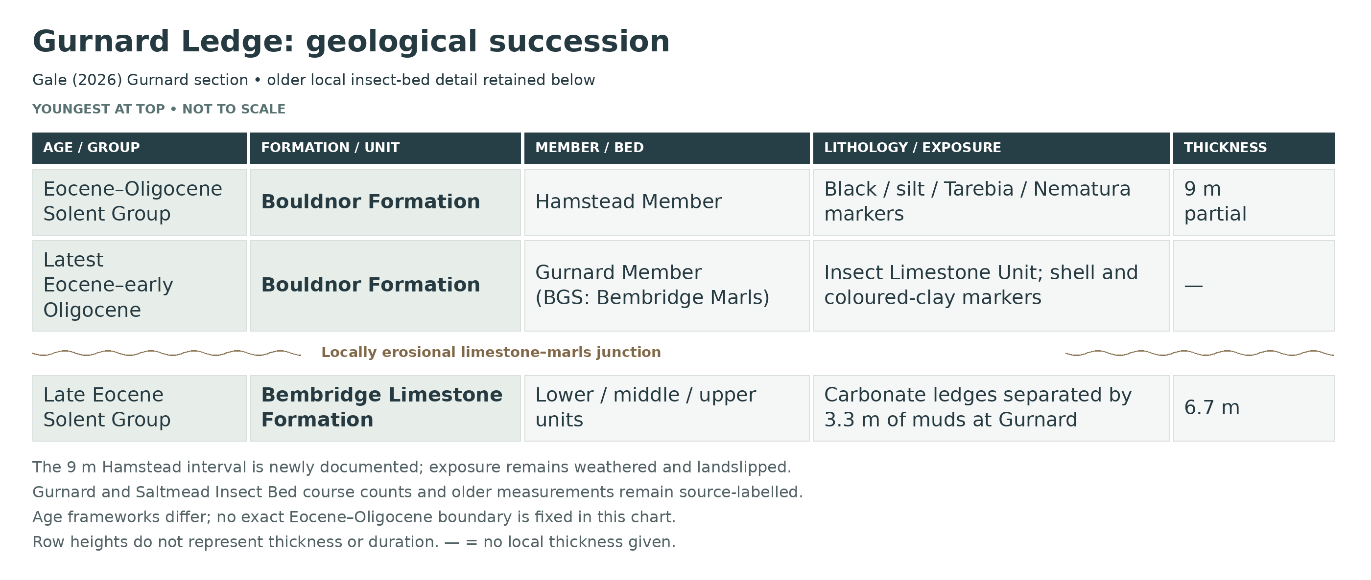
The Bembridge Marls are the basal member of the Bouldnor Formation, named Gurnard Member in the King (2016) and Gale (2026) scheme. Gale (2026) additionally documents 9 m of the Hamstead Member high in the landslipped cliffs, including the silt marker, Tarebia Bed and Nematura Bed above the basal Black Band. These sediments consist of clays and silts deposited in freshwater to estuarine environments, reflecting a shift towards river-dominated conditions. The beds are highly prone to slumping, and frequent landslips often obscure the underlying Bembridge Marls and insect bed, making exposures variable and short-lived.
The combination of laminated lagoonal sediments, limestone ledges and overlying clays makes Gurnard Ledge an important site for understanding environmental change at the end of the Eocene. Despite challenging conditions, it remains one of the most scientifically significant fossil localities on the Isle of Wight.

This is a detailed composite account of the Gurnard Ledge and adjacent northern Thorness Bay coast. The Bembridge Limestone is overlain by the Gurnard Member, termed Bembridge Marls Member in BGS (2015), and part of the Hamstead Member. Gale (2026) adds a measured 9 m local Hamstead interval to the older accounts. The insect-bearing beds, shell markers, palaeosols and the eroded limestone contact are described individually, with measurements tied to their own exposures.
Gale (2026): new Gurnard measured section
This account uses Gurnard Member for the unit called Bembridge Marls Member in BGS (2015). The names refer to the same member-level interval and are not stacked twice. The new measurements are from the partly degraded and landslipped cliff between northern Thorness Bay and Gurnard.
SOLENT GROUP
Bouldnor Formation
Gurnard Member (Bembridge Marls Member in BGS 2015)
Basal Bembridge Oyster Bed
The basal shell horizon lies on the eroded top of the Bembridge Limestone. Figure 11 shows this contact below the Insect Limestone Unit; it is a transgressive shell concentration rather than a thick imported Whitecliff sandstone.
Insect Limestone Unit
The new local log distinguishes the Insect Limestone Unit near the member base. Abundant lenses of micritic limestone preserve the exceptionally diverse insect and arachnid fauna. The older GUR IV two-course measurement remains useful as a separately attributed local observation.
T/P marker
The T/P marker caps the Insect Limestone Unit. Figure 11 distinguishes it above the micritic limestone lenses; the abbreviation is retained without assigning an unverified expanded name.
Serpulid marker
The serpulid-bearing level is separately shown above T/P and below Pc in Figure 11. It forms part of the same lower-member marker succession that Gale correlates along the northwestern coast.
Pc marker
A separate Pc marker follows the serpulid horizon. The published abbreviated label is retained; it is not assigned an invented thickness or taxonomic expansion.
Green clay above Pc
A green clay interval above the Pc marker precedes the dark clay marker. The graphic log retains this coloured-clay distinction within the rhythmically bedded lower succession.
Dark clay marker
The dark clay marker is distinct from the green intervals above and below. It lies below the prominent middle green-clay marker in the local log.
Middle green-clay marker
This conspicuous green interval lies between the dark clay marker and the Potamomya horizon. The lower succession contains grey and green clays, silts, desiccation surfaces and soil-modified cycle tops.
Potamomya marker
The Potamomya-bearing marker is separately identified between the middle and upper green intervals. Gale correlates it with the corresponding shell marker at Thorness and Hamstead, without implying identical thickness.
Upper green-clay marker
A further green-clay marker above the Potamomya horizon is separately shown in Figure 11. It is not merged with the lower green beds simply because their colours are similar.
Polymesoda obovata marker
The brackish Polymesoda obovata shell marker lies above the lower coloured-clay sequence. Figure 11 identifies it separately above the lower green markers. The correlated northwestern marker rests on a burrowed omission surface.
Upper Gurnard clay cycles
The upper succession is dominated by rhythmic clays, thin dark laminated cycle bases, rooted surfaces and concretions. These higher beds are deeply weathered and commonly poorly exposed; the old 21.5 m estimate and the new illustrated section must remain source-labelled rather than combined.
Nystia Bed
The thin brackish-gastropod horizon is retained separately near the top of the member. Gale’s text and Figure 11 differ in its precise plotted level, so no reconciled height is inferred here. Its position below the Black Band is secure.
Upper-member silt marker below Black Band
Figure 11 shows a thin silt between the Nystia Bed and the Black Band. It is distinct from the more conspicuous silt marker above the Black Band in the Hamstead Member.
Hamstead Member
Black Band and basal palaeosol
The Black Band defines the base of the Hamstead Member above the rooted top of the Gurnard Member. It is illustrated in the new Gurnard log below a substantial further Hamstead interval, extending the older account that concentrated on the poorly exposed basal marker.
Lower Hamstead clays and silts
The new section documents 9 m of Hamstead Member high in the landslipped cliffs between northern Thorness Bay and Gurnard. The beds are deeply weathered. This is a partial local section; it does not establish the complete Hamstead or Cranmore succession here.
Hamstead silt marker
A conspicuous silt marker lies above the Black Band and below the Tarebia Bed in Figure 11. Figure 15 correlates this lower Hamstead horizon with the other northwestern sections, while allowing lateral thickness variation.
Tarebia Bed
The Tarebia shell marker is identifiable above the silt marker and below the Nematura interval. Gale recognises it despite deep weathering of the Gurnard section. The separate Log Bed with giant conifer trunks at Hamstead–Bouldnor is not imported into this local section.
Nematura Bed at Gurnard
Gale identifies the Nematura Bed near the top of the newly documented local Hamstead interval. Its presence extends the older account beyond the basal Black Band. No Bouldnor White Band, Water-Lily Bed or Cranmore section is assigned to this Gurnard exposure.
Published age frameworks differ. Gale (2026) revises his earlier interpretation of the basal normal-polarity interval from C13n to C15n, agreeing with King (2016). Broad chart ages retain that uncertainty; no exact Eocene–Oligocene boundary is identified in these local sections.
Older local bed and fossil accounts
The following older descriptive framework preserves its useful numbered beds, fossils and local thicknesses. It is a separate reference scheme; newly measured member limits above supersede any earlier impression that only the Black Band was known locally.
The GL numbers are editorial guide labels. Published GUR, THOR and BW codes refer to different measured local sections; matching Roman numbers do not automatically establish correlation. Member totals quoted for Gurnard Ledge are kept tied to that section, and the separate Saltmead/Burnt Wood Insect Bed measurements are identified by locality.
Section Architecture
This locality is not a single simple cliff log. The useful section is a composite of low cliff and foreshore exposures around and immediately south of Gurnard Ledge on the northern limb of the Thorness Bay Syncline, together with equivalent beds in east Thorness Bay on the southern limb, especially north-west of Pilgrim’s Park. Exposures are generally best near the base; the higher Bembridge Marls are commonly vegetated, slipped or beach-masked, and the Black Band is only poorly exposed just south of Gurnard Ledge.
Local Stratigraphic Note
The sequence exposed in the Gurnard–east Thorness tract was formerly described from the Bembridge Limestone Formation to the basal Hamstead Black Band. Gale (2026) documents an additional 9 m local Hamstead interval, so the older less-than-30-metre summary is not a current maximum. The stratigraphy is formally documented, but the Gurnard page is best written using real lithological packages and named local horizons rather than pretending that every part of the succession is continuously visible in one face. The key published local horizon names retained here are GUR IV for the main Insect Bed at Gurnard Ledge and THOR III for a lower Bembridge Marls horizon in east Thorness Bay.
SOLENT GROUP
Bembridge Limestone Formation (Upper Eocene)
Bed GL1 — Lower Carbonate Unit Of The Bembridge Limestone
The lower part of the Bembridge Limestone at Gurnard is a buff freshwater limestone and marl package forming the main rock platform of Gurnard Ledge. It belongs to the distinctive palustrine–lacustrine Bembridge Limestone facies of the north Isle of Wight, deposited in very shallow carbonate-rich ponds and lakes subject to repeated pedogenic overprint. Ferruginous chert concretions occur in the uppermost limestone bed of this lower carbonate unit near Gurnard Ledge, and these are locally notable for silica pseudomorphs after microlenticular gypsum, showing evaporitic and pedogenic modification within the limestone. Typical fossils are freshwater gastropods and plant remains, but land-snail faunas such as those known from Prospect Quarry are not a characteristic feature of this Gurnard section.
Bed GL2 — Middle Muddy Sequence / Gurnard Bembridge Limestone Muds (c. 3.3 m)
A muddy sequence 3.3 m thick separates the lower and upper carbonate units at Gurnard. These muds and marls form the soft middle part of the local Bembridge Limestone succession and are important because the lowest parts of the Gurnard cliffs have yielded fruits and seeds from this interval. In regional terms this muddy package probably corresponds in part to the “middle muds” recognized elsewhere in the Bembridge Limestone, but the Gurnard summaries do not support a finer formal local subdivision. Depositional conditions were quieter and muddier than in the limestone packages above and below, representing shallow standing water on a low-relief carbonate plain with intermittent marsh or pond development.
Bed GL3 — Upper Carbonate Unit Of The Bembridge Limestone
The upper Bembridge Limestone at Gurnard is again composed of buff limestones and marls, but the lithology varies laterally toward the south-west and this variation has been interpreted in part as the result of contemporaneous erosion before deposition of the Bembridge Marls. The top of the unit is therefore important structurally as well as stratigraphically. Like the lower carbonate unit, it represents very shallow lacustrine to palustrine carbonate sedimentation with repeated emergence and soil-forming modification. The upper surface is locally erosional, and at Thorness Bay this contact relationship was one of the key pieces of evidence used to demonstrate previously unrecognized intra-Palaeogene warping on the Isle of Wight.
Total Thickness Of The Bembridge Limestone Formation At Gurnard Ledge: 6.7 Metres
Bouldnor Formation (Latest Eocene To Early Oligocene)
Bembridge Marls Member
Bed GL4 — Basal Oyster-Bearing And Brackish Shell-Band Interval
At Gurnard and east Thorness Bay the base of the Bembridge Marls Member rests on an erosion surface cut into the Bembridge Limestone. Unlike Whitecliff Bay, there is no well-developed basal sandy oyster bed here, but oysters do occur in two shell bands at the base of the succession, and the lower part broadly represents the local equivalent of the traditional lower “oyster-bed” interval. The lithology is mainly grey, blue-green and green mud with marlier beds low in the sequence. Numerous burrowing bivalves occur in life position toward the base, and shell preservation varies strongly with lithology: shells are best preserved in grey clays, whereas those from blue-green clays may be friable, chalky or completely decalcified. This basal package records the initial brackish to hyposaline flooding of the Gurnard carbonate surface in a quiet, sluggish estuarine or lagoonal setting.
GUR III — Shell band below the Insect Bed
Jarzembowski’s local section shows a shell-rich band with corbiculid bivalves, small Tarebia and larger Potamides below GUR IV. This is distinct from the upper shell marker GUR V.
THOR III — Southern-limb algal horizon
West of Pilgrims Park, the GCR records the shell-encrusting alga Epivalvia edwardsii in lower Bembridge Marls bed THOR III. This is a separate local section on the southern limb and is not placed above GUR IV merely because it is discussed alongside the Gurnard succession.
Bed GL5 — Bembridge Insect Bed / “Insect Limestone” / GUR IV
The Bembridge Insect Bed lies near the base of the Bembridge Marls Member at Gurnard; Jarzembowski’s Figure 3 shows 0.66–0.82 m of basal GUR I–II beds below the GUR III shell band that underlies it and is the most important single horizon in the whole Gurnard section. Although traditionally called the “Insect Limestone”, it is not one simple limestone bed; at Gurnard it consists of a predominantly argillaceous horizon with discontinuous concretionary limestones, hard marls and, in places, a more tabular micritic limestone commonly around 10 cm thick, whereas Jarzembowski measured the whole GUR IV interval at 0.65–0.75 m, comprising a lower relatively continuous limestone course and an upper discontinuous concretionary course. Fossils include an exceptionally rich insect fauna, spiders, fairy shrimp, isopods, ostracods, rare bird feathers, a fragment of lizard skin, freshwater gastropods such as Galba, the brackish bivalve Polymesoda, and abundant plant remains including Typha, Potamogeton, Limnocarpus and seeds of Stratiotes. Preservation is famously exquisite, with three-dimensional insect and spider tissues mineralized in calcite. The associated fairy shrimp, the scarcity of fish, and pseudomorphs after halite in the bed and gypsum in adjacent marls indicate episodes of abnormal, probably hypersaline, water chemistry within an otherwise brackish to freshwater marsh-lagoon system.
Individual calcareous courses in the older local logs
These descriptions follow Jarzembowski’s figures from field observations in 1976–77. The two named local sections are kept separate; no course-specific fossil list or scale-derived thickness is added.
Gurnard GUR IV: lower limestone course
Jarzembowski’s 1976–77 Gurnard log shows a lower, relatively continuous limestone course within the 0.65–0.75 m whole Insect Bed. That whole-bed range does not measure this lower course alone.
Gurnard GUR IV: upper concretionary course
A separate upper course comprises discontinuous concretions in the clay-rich interval. These two Gurnard courses differ from the four-course Saltmead development. No one-to-one numerical matching of individual courses, or distinct course-specific insect fauna, is established.
Saltmead BW IV: lower nodular course
Jarzembowski’s 1976–77 Saltmead observations distinguish a lowermost nodular calcareous course within the laminated marly-clay Insect Bed. It lies above the BW III shell band. Its course thickness is not read from the drawing’s scale.
Saltmead BW IV: second limestone and hard-marl course
The next calcareous course contains limestone and hard marl, separated from the lower nodular development by more argillaceous sediment. It remains one course within BW IV, not a separately named formal bed.
Saltmead BW IV: very thin third hard-marl course
A particularly thin hard-marl course is individually shown above the second course. Its separate position is retained without inventing a numerical thickness or a diagnostic fossil assemblage.
Saltmead BW IV: upper large-concretion course
The upper course consists of comparatively large, discontinuous limestone concretions within the marly-clay interval below BW V. The four-course Saltmead architecture is a historical exact-locality observation, not a four-bed template imposed on every Insect Limestone exposure.
GUR V — Shell band above the Insect Bed
The published Gurnard section shows a second shell band above the muddy, two-course Insect Bed. The lower and upper shell bands bracket GUR IV and are useful markers; they are not additional limestone courses within it.
Bed GL6 — Lower To Middle Bembridge Marls Above The Insect Bed
Above the Insect Bed the Bembridge Marls continue as black, grey and green muds with scattered marls and shell-bearing levels. These beds contain good brackish to freshwater molluscan assemblages and show the strongly fluctuating salinity typical of the member as a whole. The marls above Gurnard Ledge and their southern-limb equivalents were deposited in shallow, low-energy waters with extensive marshland and intermittent open water.
GUR IX — Serpulid-rich marker
The GCR identifies a very thin serpulid-rich unit in the lower Bembridge Marls as GUR IX after Daley (1973). It is a useful traceable faunal marker above the Insect Bed, but no separate measured thickness is supplied here.
Bed GL7 — Upper Bembridge Marls Varicoloured Mud Sequence
The upper part of the Bembridge Marls at Gurnard is dominated by black, grey and green muds and silts with shell seams and local ironstone nodules. Some plant remains described historically from the Gurnard section came from these higher Bembridge Marls rather than from the Insect Bed itself, and the ironstone nodules are mainly associated with freshwater gastropod-bearing levels. Modern vegetation and slipping obscure much of this interval, but the published Gurnard log does distinguish shell horizons and exposure gaps. These recorded subdivisions are retained below rather than discarded because present visibility is poor. The overall trend is regressive, with fluctuating salinity but increasing freshwater influence upward through sluggish marsh, lagoon and low-energy fluvial-margin environments.
Corbicula Bed — GUR XXIV
GCR Figure 5.45 marks a conspicuous corbiculid shell concentration at GUR XXIV, approximately mid-member. It lies among muddy and locally shelly intervals, rather than forming a separate formation or member.
Upper exposure gaps and Nystia Band
The same local log records about 3 m without exposure below GUR XXX and a further gap of about 0.5 m beneath GUR XXXIII. The Nystia Band is marked at the base of the highest logged package. These are documented gaps and a named shell horizon; none is replaced by invented continuous bed descriptions.
Additional individual horizons in the older Gurnard Ledge log
The following entries follow the actual numbered graphic in GCR Figure 5.45, after Daley (1973). They supplement the retained GUR IX, Corbicula and Nystia descriptions. Numbered levels and graphical lithologies stay in that historical scheme; no exact crosswalk to Gale (2026) or thickness measured from the drawing is implied.
GUR XV — Separate shell horizon
Figure 5.45 shows a shell-bearing level at XV below the laminated XVI–XVII interval. It is retained as a distinct molluscan concentration without supplying a species list or a scale-derived thickness.
GUR XVI–XVII — Laminated interval
The interval between the XV and XVIII shell levels is separately shown with fine sedimentary lamination. It is not merged into one structureless clay package.
GUR XVIII — Shell horizon above the laminated beds
A further shell-bearing level at XVIII caps the preceding laminated interval. Its position distinguishes it from XV below and the later shell concentrations higher in the member.
GUR XX — Laminated lower part
The numbered XX package includes a laminated lower interval above XIX. The figure does not establish an independent thickness or formal bed name for that laminated component.
GUR XXII — Shell horizon
The shell-bearing XXII level lies above XXI and below the thicker XXIII mud interval that precedes the Corbicula Bed. Its fauna is not automatically equated with that named higher shell bed.
GUR XXVI — Shell horizon above the Corbicula interval
A separate shell concentration at XXVI follows the intervening XXV muds above the Corbicula Bed at XXIV. Several shell incursions are therefore represented, not one continuous corbiculid band.
GUR XXVII — Laminated and rooted upper part
The upper part of the XXVII clay package is laminated and rooted beneath the dark lignitic band. These contacts record a change within the older log rather than an inferred new formation boundary.
GUR XXVIII–XXIX — Lignitic band and overlying clay
The conspicuous dark lignitic level at XXVIII overlies the rooted top of XXVII and is followed by the XXIX clay interval. The approximately 3 m non-exposure gap lies above this package in the published log; it is not filled with invented lithologies.
GUR XXX–XXXII — Clay package with dark seams
Above the larger exposure gap, Figure 5.45 shows clays numbered XXX–XXXI with a dark seam at their junction and another dark boundary near XXXII. A separate non-exposure gap of about 0.5 m follows below the Nystia-bearing highest package.
GUR XXXIV — Clay above the Nystia Band
The Nystia shell marker at XXXIII is followed by the XXXIV clay interval. No direct equivalence with a particular Gale cycle is imposed.
GUR XXXV — Separate hard band
A distinct hard band is shown in the upper part of the old graphical log at XXXV. Its independent position is retained without naming an unverified mineral composition or calculating a thickness from the illustration.
GUR XXXVI — Laminated upper interval
The laminated XXXVI interval lies above the separate hard band. It provides another visible sedimentary subdivision near the top of the old Gurnard Ledge log.
GUR XXXVII — Rooted top
The uppermost numbered interval bears roots beneath the Hamstead Member. This rooted contact is distinct from the lower lignitic and rooted levels and is preserved as part of the old graphic scheme.
Total Thickness Of The Bembridge Marls Member At Gurnard Ledge: 21.5 Metres
Hamstead Member
Bed GL8 — Black Band (c. 0.4 m; Poorly Exposed Just South Of Gurnard Ledge)
The Black Band is the basal marker bed of the Hamstead Member and is only poorly exposed in this locality, just south of Gurnard Ledge. Where recognizable it is a dark brown to black shelly organic-rich clay with scattered angular flint pebbles, lying above an omission surface and a rooted palaeosol with calcrete-like concretions developed at the top of the Bembridge Marls. It contains a freshwater fauna and flora and marks a sharp environmental change from the varicoloured brackish to freshwater Bembridge Marls below into the more fully continental lower Hamstead regime above. The older account emphasised this poorly exposed basal marker; Gale (2026) now provides a fuller local Hamstead log above it.
Depositional Environment
The Gurnard Ledge–east Thorness Bay tract records repeated shifts across a low-relief late Eocene to earliest Oligocene marginal basin. The Bembridge Limestone formed in very shallow carbonate-rich lakes, ponds and palustrine flats under relatively arid conditions, with pedogenic modification, local evaporitic gypsum growth and repeated emergence. The overlying Bembridge Marls record a broad regressive brackish to freshwater succession deposited in a sluggish estuary or lagoon with extensive marshland, some open water, nearby woodland and intermittent fluvial influence. Salinity fluctuated repeatedly: the basal shell-band interval records the initial flooding of the Bembridge Limestone surface, the Insect Bed reflects a very quiet but chemically unusual pool or marsh-water setting with exceptional fossil preservation and local hypersaline episodes, and the higher marls record continued marsh, lagoonal and low-energy freshwater deposition leading up to the palaeosol and Black Band at the base of the Hamstead Member. The erosional and locally unconformable junction between the Bembridge Limestone and Bembridge Marls shows that sedimentation here was influenced by intra-Palaeogene warping as well as by simple facies change.
Older GCR Thickness Framework: 6.7 Metres Of Bembridge Limestone And 21.5 Metres Of Bembridge Marls; Newer Hamstead Exposure Described Separately
References
Hopson, P.M. & Farrant, A.R. (2015). Geology of the Isle of Wight, British Geological Survey sheet explanation.
British Geological Survey Lexicon of Named Rock Units: Bembridge Limestone Formation, Bembridge Marls Member and Hamstead Member.
Daley, B. (1972a, 1972b, 1972c, 1973a, 1974) on the Bembridge Marls succession, macroinvertebrate assemblages, deformation structures and algal remains of Thorness Bay and Gurnard.
Daley, B. & Balson, P. (1999). British Tertiary Stratigraphy, Geological Conservation Review accounts for Thorness Bay and Gurnard.
Daley, B. & Edwards, N. (1971). Palaeogene warping in the Isle of Wight.
Daley, B. & Edwards, N. (1990). Stratigraphical revision of the Bembridge Limestone, Isle of Wight.
Insole, A. & Daley, B. (1985). Revision of the late Eocene and early Oligocene lithostratigraphy of the Hampshire Basin.
Armenteros, I., Daley, B. & García, E. (1997). Lacustrine and palustrine facies in the Bembridge Limestone of the Isle of Wight.
Jarzembowski, E.A. (1980a, 1980b) on the insect fauna of the Bembridge Insect Bed.
McCobb, L.M.E., Jarzembowski, E.A. and co-authors (1998) on the lithology and taphonomy of the Insect Bed.
Collinson, M.E. and co-authors on the Bembridge Flora and the contrasting floras of the Bembridge Limestone and Bembridge Marls at Gurnard.
Checked sources: Hopson and Farrant (2015), Isle of Wight, Solent Group; Daley and Balson (1999), GCR15: Thorness Bay and Gurnard, Figures5.43–5.45; Cleal and colleagues (2001), GCR22: Thorness Bay; Jarzembowski (1980), Fossil insects from the Bembridge Marls, pp.240–243, Figs2–3; Ross and Self (2014), The fauna and flora of the Insect Limestone: introduction, history and geology.
Additional source: Gale (2026), Bouldnor Formation stratigraphy, section 4, Figures 11, 14–16.
SAFETY
Common sense should always be used when collecting, and checking tide times is essential. The sea can reach the base of the cliffs, so it is important to begin your return before the tide turns, as it is easy to become cut off along this stretch of coast.
The foreshore can be hazardous, with slippery rocks, especially when wet or covered in algae, so extra care should be taken when walking. In addition, there are often areas of deep, soft mud on the lower foreshore, which can be difficult to cross and may pose a risk of becoming stuck—these areas should be avoided.
Cliff falls and slumping also occur, so do not stand close to the cliff base and remain aware of your surroundings at all times.
EQUIPMENT
A geological hammer and fine chisel can be useful on permitted loose pieces of Bembridge Insect Bed limestone on firm, open foreshore, well clear of cliff bases and unstable ground. Wear safety goggles, keep others clear and inspect each split surface before striking again. If a fossil appears, stop and retain both matching pieces.
For permitted loose marl samples, a small trowel and labelled sample bags or containers can help with later examination and sieving. Do not use digging tools in cliffs, banks or attached beds.
It is also important to bring tissue or padding, as many fossils—especially insects, shells and delicate fragments—can be extremely fragile and easily damaged. A sturdy bag or backpack will help safely carry both tools and finds.
As conditions can often be muddy and slippery, waterproof footwear with good grip is strongly recommended.
CLEANING AND TREATING
Keep insect-bearing slabs and their matching counterparts supported, labelled and separate. Do not brush directly across wings, cuticle or other delicate impressions. Do not routinely soak every find for 24 hours: water may soften clay-rich matrix or harm unstable material, and salt removal needs a specimen-specific plan. Avoid heat and rapid drying; seek preparation advice before treating an important or crumbling specimen.
Paraloid B-72 can help selected fragile areas after testing, but sound fossils do not automatically need coating. It is not a waterproof seal, and complete removal from porous fossil or matrix cannot be guaranteed. Keep specimens supported in stable storage and document any treatment. Delicate impressions and scientifically important finds should be assessed before applying adhesive or consolidant.
IDENTIFY YOUR FINDS
Need help identifying a fossil? Share clear photos, where you found it and its size with the community.
FURTHER READING
GCR / GeoGuide – Thorness Bay and Gurnard, Isle of Wight
GCR / GeoGuide – Thorness Bay — fossil plants
UCL research paper – Vertebrate remains from the Insect Limestone (latest Eocene), Isle of Wight, UK (wider Insect Limestone outcrop; PDF)
British Geological Survey – Geology of the Isle of Wight (island-wide geological context)
ACCESS RIGHTS
Use lawful public access, follow current local signs and any closures, and obtain any collecting permission needed. Collect only permitted loose material; do not dig into the cliffs or hammer attached bedrock. Follow the UK Fossils Code of Conduct.
It is important to follow our ‘Code of Conduct’ when collecting fossils or visiting any site. Please also read our ‘Terms and Conditions‘
LINKS
♦ Fossil Discussions
♦ Fossil Articles
♦ Buy Fossils, Tools and Equipment
♦ Buy Crystals, Meteorites, and Artefacts
♦ Join Fossil Hunts
♦ UK Fossils Network