Hinkley Point is a productive coastal site where fish and reptile remains, including ichthyosaur vertebrae, are commonly found loose along the foreshore. The beach also yields ammonites and marine shells, often exposed after erosion, making it a rewarding location for collectors searching for vertebrate material.


FIND FREQUENCY: ♦♦♦ – This location is highly productive after winter storms for reptile and fish remains, but ammonites and shells are less common.
CHILDREN: ♦♦♦ – Although this location is suitable for families, it is best suited to the fossil enthusiast because most of the fossils can only be found after winter storms and high tides.
ACCESS: ♦♦ – Access to the beach can be made from Knighton. It’s a fairly long walk and the car parking area is along an unmade track.
TYPE: This is a foreshore and cliff location, so fossils can be found in both. However, the vast majority of fossils are found exposed loose on the foreshore after high tides, or during scouring conditions.
DIRECTIONS
♦ This location is best accessed from Knighton, but is poorly signposted. The best way is to drive to Stogursey and, from there, you will see a signpost to the village of Burton. At Burton, a narrow road leads to Knighton. It is signposted on the right hand side as ‘Knighton’ across a wall. This cannot be seen if driving from Shurton and is easily missed.
♦ Follow the road through the village. It will then come to a left hand bend and a farm track. Follow this track up and over the hill, and up and over the next hill. This is an unmade road and full of potholes, used mostly by farm vehicles. You will see a large sign saying vehicles are not permitted past this point. However, there are plenty of parking spaces before it, you will need to walk the remainder of track.
♦ Continue to follow the farm track by foot until you reach the cliff. Walk right until the cliff dips. Here, you can easily descend to the shore. Carry on walking to the right along the foreshore.
♦ Car Parking Postcode: TA5 1QD; Google Maps Link
♦ Site location: What3Words: ///whirlpool.trading.engages
VIDEO FILM
FOSSIL HUNTING
Hinkley Point is a highly productive fossil-hunting locality, best known for its abundance of Early Jurassic marine reptiles and associated marine fauna. Regular tidal action continually exposes new material, making careful searching of the foreshore particularly rewarding.


Marine reptile remains are among the most frequent and recognisable finds. Ichthyosaur material is very common here, but isolated vertebrae, ribs and bone fragments cannot usually be assigned securely to a genus or species without diagnostic material and specialist comparison. Typical finds include vertebrae, ribs, limb elements and occasional jaw fragments, with teeth being found less frequently. Most material is disarticulated, but the density of remains makes this an excellent site for reptile collectors.
Ammonites are widespread and occur in a range of sizes. The published Hinkley foreshore section records ammonites including Schlotheimia, Vermiceras, Coroniceras and Arnioceras, from successive late Hettangian and early Sinemurian beds. Many specimens show a pronounced ammonite keel, which can sometimes be seen weathering out on exposed surfaces. Ammonites are most often found within blocks of Blue Lias limestone rather than loose on the beach, and these blocks rarely split cleanly. If a specimen is visible as a clear ammonite keel or partial whorl protruding from the rock, it is usually best to collect the entire block and prepare it later rather than attempting to split it in the field.
Bivalves and other shells are frequent and include flattened and partial specimens, with better-preserved examples appearing after periods of erosion. While not always visually striking, they are an important part of the site’s fossil assemblage.
Fish remains are another notable feature of Hinkley Point. Scales, vertebrae and fin elements are commonly found, particularly within shale. Isolated scales and fragments need specialist comparison before a genus or species can be assigned. With careful searching, partially articulated fish and, more rarely, near-complete specimens can be found exposed on the foreshore. These fossils are delicate and should be handled with care.
Crinoid material is also present, most notably as crinoid-rich limestone blocks. They may contain columnals, stem fragments and occasionally more complex articulated sections; isolated stem pieces should not automatically be assigned to a particular crinoid genus. Such blocks are usually heavy and weather slowly, but can yield attractive specimens with preparation.
At the base of the cliffs, fossils are frequently found within the first metre above normal beach height. After high tides, bones and fossil fragments are often washed out and redistributed across the foreshore, making post-tide searches particularly productive. Always maintain a safe distance from the cliffs, as rock falls can occur without warning.

Some of the most significant fossil discoveries and scientific milestones from Hinkley Point include important Early Jurassic marine reptile finds, notable ichthyosaur discoveries from the foreshore and nearby Bridgwater Bay, and modern fossil rescues connected with the Hinkley Point coast.
1983 – Whittaker and Green publish the Hinkley reef-bed log
Whittaker and Green’s Geological Survey memoir documented the measured section across the reefs at Hinkley Point Power Station, numbered beds 130–238. The published log records limestone, mudstone and shale, with ammonite evidence spanning the Angulata, Bucklandi and lower Semicostatum zones; some thicknesses were calculated where direct measurement was not possible.
2002 – large Ichthyosaurus skeleton found at Hinkley Point by Alister Cruickshanks
In 2002, Alister Cruickshanks discovered about three quarters of an Ichthyosaurus skeleton at Hinkley Point. This became one of the most notable modern marine reptile finds from the locality and showed how productive the foreshore can still be after scouring conditions.
2003 – the Collard plesiosaur found near Hinkley Point in Bridgwater Bay
In 2003, Nicholas Collard discovered the famous Collard plesiosaur in Bridgwater Bay near Hinkley Point. It was especially important because it was described as the only complete and fully articulated plesiosaur skeleton found in Britain for over 100 years.
2010 – detailed preparation and study of the Collard plesiosaur published
The Collard plesiosaur was later prepared and studied in detail using both physical preparation and imaging techniques. This work turned the discovery into one of the best documented marine reptile fossils from the wider Hinkley Point coast.
2019 – ichthyosaur bone discovered during Hinkley Point C works
In 2019, Rachel Trick spotted a 4 × 5 cm fossil bone during works at Hinkley Point C. It was identified as coming from an ichthyosaur and was removed for preservation, showing that important marine reptile material is still being found in the Hinkley Point area today.
GEOLOGY
The coastline at Hinkley Point exposes a classic sequence of Lower Jurassic (Early Jurassic) strata, making it one of the most important and instructive geological sections in Somerset. The cliffs and foreshore here are dominated by the Blue Lias Formation, a unit well known for its alternating limestones and shales and its exceptional fossil content.
The Blue Lias at Hinkley Point is characterised by rhythmic bedding, with harder limestone layers interbedded with softer, darker shales. These repeating layers reflect changes in sedimentation during the Early Jurassic, with quieter marine conditions allowing fine muds to settle, interrupted by periods of increased carbonate deposition forming limestone beds. This alternating sequence is clearly visible along the cliff faces and across the foreshore, particularly at low tide.
The limestone beds form prominent ledges and platforms on the foreshore and are generally more resistant to erosion. These beds often weather into large, blocky slabs that may contain fossils but rarely split cleanly. In contrast, the shale layers are much softer and erode more rapidly, breaking down into muds and thin fragments. This differential erosion plays a major role in fossil exposure, as fossils weather out of the softer shales and are released onto the beach.

The cliffs themselves are actively eroding, with frequent small-scale collapses and slumping. This erosion is a key factor in continually refreshing the fossil supply, as new material is regularly exposed and washed down onto the foreshore. However, this also makes the area hazardous, and the cliff base should be treated with caution at all times.
The foreshore geology is strongly influenced by tidal action, with high tides and storm events redistributing loose material and exposing fresh surfaces. After periods of rough weather, newly eroded shale patches and freshly broken limestone blocks are often visible, offering the best opportunities for finding fossils. Between tides, the foreshore can appear relatively barren, but subtle changes in erosion frequently reveal new material.
Localised variations within the Blue Lias sequence can be observed along the coast, with some beds being more fossiliferous or more prone to erosion than others. These variations explain why certain stretches of foreshore are consistently more productive than others, even over relatively short distances.

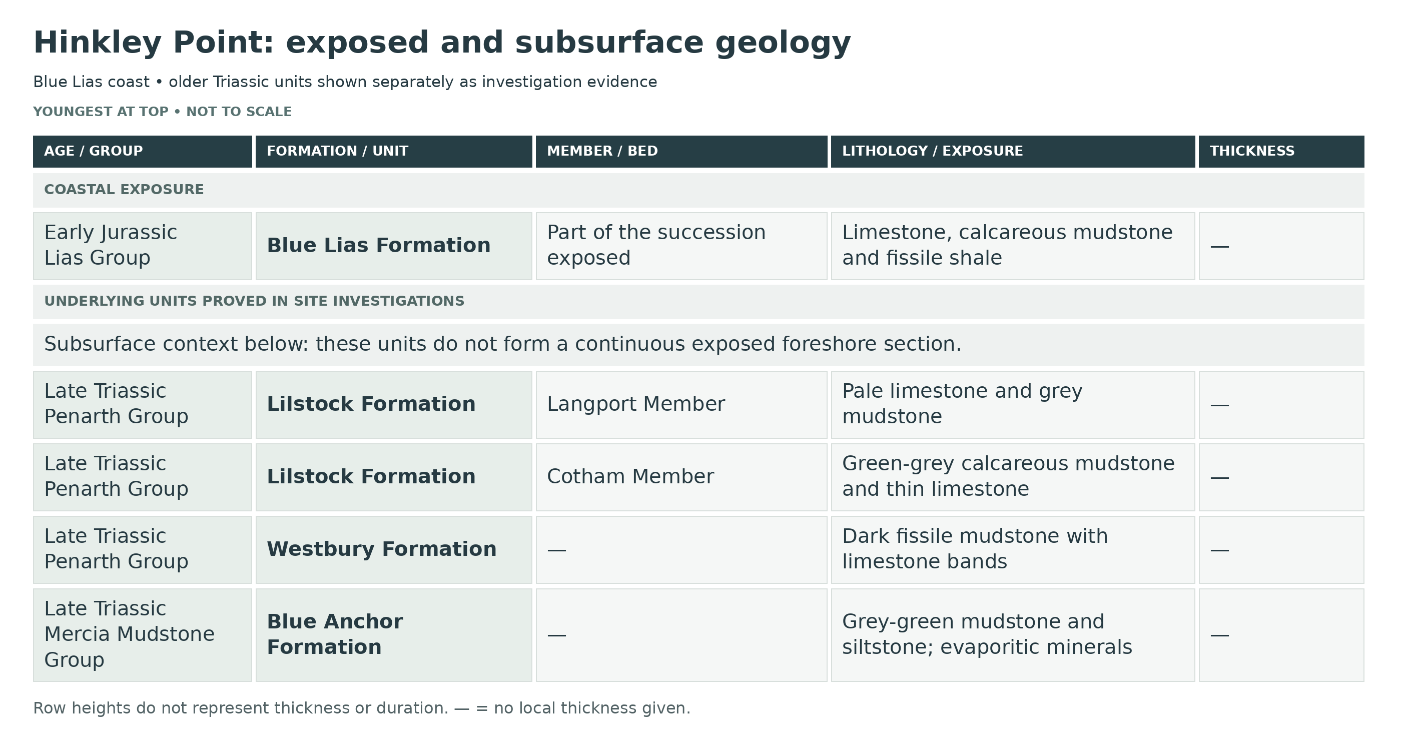
This is a detailed stratigraphic breakdown of the late Triassic to early Jurassic succession at Hinkley Point, where low foreshore cliffs and rock platforms expose part of the Blue Lias Formation while boreholes beneath the headland prove the underlying Blue Anchor Formation and Penarth Group. The section is important as the eastern end of the classic west Somerset Blue Lias coast and for showing how the expanded Hettangian–lower Sinemurian marine limestone–mudstone cycles rest on thin Rhaetian transgressive beds.
MERCIA MUDSTONE GROUP
Only the Blue Lias is normally exposed in the Hinkley Point sea cliffs and foreshore. The underlying Blue Anchor Formation and Penarth Group are not usually visible in the coastal face but are securely proved beneath the point by site investigations, and they are included here because they form the full local pre-Lias succession below the exposed Jurassic beds.
Blue Anchor Formation (Upper Triassic)
Blue Anchor Formation (Subsurface; Earlier Summary Up To 38 m)
The uppermost Mercia Mudstone Group beneath Hinkley Point consists of pale to dark grey-green silty mudstones and siltstones, locally dolomitic, with thin laminae, dolomitic bands and evaporitic components including gypsum, anhydrite and occasional halite. At Hinkley it is known chiefly from boreholes and geotechnical investigations rather than from the sea cliff itself. These beds represent the final marginal-marine to restricted shallow-water phase of Mercia sedimentation before the full Rhaetian marine transgression. Their green-grey colour, fine lamination and evaporitic overprint indicate fluctuating salinity and periodic restriction, very different from the darker open-marine mudstones of the Penarth Group above.
Depositional Environment
Restricted lagoonal to sabkha-influenced mudflat and shallow-marine conditions, with intermittent marine influence and evaporite formation near the top of the Triassic basin fill.
PENARTH GROUP
Westbury Formation (Upper Triassic)
Westbury Formation And Basal Bone-Bed Facies (Subsurface; Earlier Summary Up To 14 m)
At Hinkley Point the Westbury Formation is proved beneath the Blue Lias as a package of very dark shaly mudstones with dark grey argillaceous limestones. Regionally this formation commonly begins with one or more erosive phosphatic bone beds above the top of the Blue Anchor Formation, followed by black to dark grey marine shales and thin shelly limestones. In west Somerset the Westbury marks the main Rhaetian marine flooding event, and the dark colour, pyrite-rich aspect and shell-poor black-shale facies indicate oxygen-restricted bottom conditions. The Hinkley borehole sequence is entirely consistent with that interpretation, even though the sea cliff itself does not normally expose these beds.
Typical Fossils
Typical west Somerset Westbury fossils include bone-bed debris, fish teeth and scales, phosphatic nodules, oysters and other marine bivalves, with rare marine reptile material regionally. Those fossil concentrations are important to the local Triassic–Jurassic transition, but they are not currently known as a regularly exposed Hinkley Point foreshore horizon.
Depositional Environment
Shallow marine transgressive muds deposited under restricted to dysoxic bottom-water conditions during the major Rhaetian sea-level rise.
Lilstock Formation (Upper Triassic)
Cotham Member
Cotham Member (Subsurface; Earlier Summary Up To 2 m)
The Cotham Member beneath Hinkley Point is a thin but important interval of pale grey to greenish-grey calcareous mudstones with thin limestones, siltstones and sandstones. In regional west Somerset sections it is generally soft, laminated and only sparsely fossiliferous except near the base, and it commonly records fluctuating salinity, intermittent emergence and low-energy lagoonal deposition. The member is rarely more than a couple of metres thick, but it is a key marker because it separates the dark marine Westbury shales from the harder pale limestones of the Langport Member above.
Depositional Environment
Restricted lagoonal to mudflat conditions with fluctuating salinity, episodic exposure and only limited benthic faunal development.
Langport Member
Langport Member / Sun Bed Interval (Subsurface; Earlier Summary Up To 2 m)
The Langport Member at Hinkley Point is a thin but distinctive pale limestone-and-mudstone interval forming the top of the Penarth Group. Site investigations describe pale grey limestones with interbedded grey to bluish grey mudstones; regionally, these are the hard, pale, fine-grained limestones long known as White Lias. The topmost Sun Bed is the key marker horizon at the Triassic–Jurassic transition across southern Britain and may show signs of boring or emergence on its upper surface. At Hinkley Point this unit is not usually visible in the low coast section, but it is critical because the Blue Lias begins immediately above it.
Typical Fossils
The Langport Member carries a restricted shallow-water fauna of bivalves, gastropods and ostracods, with plant fragments and rare simple corals locally in west Somerset correlative sections. The fauna is generally low diversity, reflecting very shallow, intermittently stressed marine conditions close to the top of the Triassic.
Depositional Environment
Very shallow restricted marine carbonate sedimentation with intermittent emergence at the top of the member.
LIAS GROUP
Blue Lias Formation (Latest Triassic To Lower Jurassic)
At Hinkley Point the coastal exposure is a low 5–10 m cliff and foreshore pavement rather than a high continuously measurable cliff. The sea front exposes only Blue Lias, the beds dip northwards at about 7–9°, and the locality is best understood as the eastern end of the expanded west Somerset Blue Lias coast rather than as a standalone numbered type section.
The BGS memoir correlates Hinkley Point foundation excavations and boreholes with beds 60–204 of the numbered coastal succession. It also publishes a separate bed 130–238 section across the reefs at the power station, spanning the Angulata, Bucklandi and lower Semicostatum zones. Some reef thicknesses, especially in shale, were calculated where direct measurement was impossible. The subsurface correlations and coastal log are distinguished below; neither is a claim that every bed is exposed in one cliff or accessible on every tide.
Basal Blue Lias Above The Sun Bed (subsurface local correlative)
The base of the Blue Lias at Hinkley Point is the base of the first fissile mudstone above the Langport Member Sun Bed. As elsewhere on the west Somerset coast, the lowest few metres are likely to include latest Rhaetian pre-Planorbis beds passing up into the first psiloceratid-bearing Hettangian strata. Hard grey limestones, calcareous mudstones and dark fissile paper shales characterize this transition. Although this basal interval is not described in a formal Hinkley Point measured coastal log, it is a necessary local correlative because the Penarth Group is proved directly beneath the exposed Blue Lias in site investigations.
Lower Blue Lias Limestone–Mudstone Cycles (main exposed foreshore interval)
The main visible Hinkley Point section consists of repeated thin limestone–mudstone cycles. Argillaceous limestones, commonly about 0.10–0.30 m thick, alternate with calcareous mudstones and fissile dark grey to black shales; some beds are laminated, some nodular, and weathered mudstones break down to clay while the limestones stand out as low ledges and pavements on the foreshore. This is the characteristic lower Blue Lias offshore facies of the Bristol Channel Basin, deposited well away from littoral carbonate shoals, with repeated small-scale changes in carbonate precipitation, mud supply and bottom-water oxygenation.
Ammonite-Bearing Hettangian To Lower Sinemurian Levels In The Hinkley District
The numbered Hinkley reef section provides direct late Hettangian to early Sinemurian ammonite control. Nearby inland exposures provide additional evidence for older Blue Lias beds in the district. Old quarries east of Stogursey and near Cockwood yielded interbedded shales and limestones with Psiloceras planorbis, while a nearby pit south of Hill Farm also contained P. planorbis; another pit very close by yielded Coroniceras and was thought to lie in the Bucklandi Zone. These records show that beds of lower Hettangian and lower Sinemurian age are present on the Hinkley–Stogursey block and help anchor the Hinkley Point Blue Lias within the Planorbis to Bucklandi part of the regional succession.
Higher Blue Lias District Continuation And The Unconfirmed Top Of The Formation At Hinkley Point
Across the wider west Somerset coast between Blue Anchor and Hinkley Point, the Blue Lias continues upward to about the middle of the Semicostatum Zone, and mudstone-dominated upper parts farther west include shale-rich and locally bituminous intervals with fewer limestones. The earlier environmental-appraisal summary listed up to 140 m for the Blue Lias in its stratigraphic framework. The later site report records a maximum encountered vertical thickness of approximately 72 m in the northern site; neither value is a measured thickness of the present foreshore cliff. The overlying Charmouth Mudstone Formation has not been confirmed in the Hinkley Point cliff sections or in the main onshore investigations, so the point should be treated as a Blue Lias locality rather than as a complete lower Lias coast section.
Structural Style And Preservation Of The Section
The Hinkley Point beds are gently but consistently north-dipping and are affected locally by east–west faults associated with the Hinkley Point structural zone. Small-scale faulting and differential weathering can repeat or truncate individual beds on the foreshore, and the section should not be forced into a single uninterrupted cliff log. Inland, the same structural setting brings Penarth Group and upper Mercia strata closer to the surface south of the point, helping explain why the locality combines low coastal Blue Lias exposure with a much fuller subsurface Triassic–Jurassic record.
Published Hinkley Bed Correlations
Beds 60–64: Liasicus-Zone Correlation
The BGS records Waehneroceras?, Psilophyllites and schlotheimiids around 59.54–60.25 m depth in the cited Hinkley borehole. These occurrences identify the lower part of the locally investigated succession and retain the source’s uncertainty in the first identification.
Beds Below 147: Angulata–Bucklandi Transition
In the Hinkley borehole, Angulata-Zone ammonites were recorded 1.60 m below the base of bed 147. The memoir places the Bucklandi-Zone base in the thick mudstone below that limestone. This is a local correlation and must not be confused with the formal East Quantoxhead GSSP itself.
Bed 154 Equivalent: Lower Sinemurian Limestone And Mudstone
Hinkley strata correlated with coastal bed 154 yielded Vermiceras solaroides and Vermiceras conybeari in the historical BGS account. The names and bed attribution are retained as the published correlation, without asserting a newly verified modern species identification.
Beds 159–161 And The Metophioceras Bed
The memoir relates the youngest beds in the main historic investigation area to beds 159–161. Its regional description traces the recognisable bed 161, traditionally called the Metophioceras Bed, eastwards to Hinkley Point, with large arietitid ammonites on the lower surface. Historical subzone assignments differ from later zonations, so the bed number is retained without forcing an outdated subzone boundary.
Published Hinkley Reef Log — Beds 130–238
The following bottom-to-top inventory follows the BGS Benhole Farm–Stolford table for the reefs at Hinkley Point Power Station. Thicknesses are in metres and include calculated values where direct measurement was not possible. Grouped numbers are retained where the source logs beds together; multiple thicknesses within a bed refer to its component layers in the source’s top-to-bottom order. Fossil names and zonal positions are those of the historical account, not new identifications. This is a geological record, not advice to reach offshore reefs or a guarantee of present exposure.
Schlotheimia angulata Zone — historical BGS zonation
Bed 130 (0.17 m)
Slightly lenticular limestone.
Beds 131–133 (0.32 m)
Mudstones with two thin limestone bands.
Bed 134 (0.22 m)
Limestone.
Bed 135 (1.10 m)
Shale.
Bed 136 (0.46 m)
Limestones with a mudstone parting.
Beds 137–141 (4.01 m)
Shales with two 0.3-m limestone bands.
Beds 142–144 (0.47 m)
Limestones with a 0.01-m mudstone parting.
Bed 145 (1.74 m)
Shale. Schlotheimia.
Arietites bucklandi Zone — historical BGS zonation
Bed 146 (0.61 m)
Shale. Vermiceras.
Bed 147 (0.75 m)
Limestone in three bands with mudstone partings.
Beds 148–152 (0.90 m)
Shale, poorly exposed.
Beds 153–157 (1.74 m)
Limestone in three bands separated by shales.
Bed 158 (1.79 m)
Shales with a 0.20-m rather lenticular limestone. Vermiceras in lower shale.
Bed 159 (0.18 m)
Persistent limestone.
Bed 160 (0.43 m)
Shale.
Bed 161 (0.28 m)
Massive and persistent limestone; the Metophioceras Bed.
Beds 162–164 (1.90 m)
Shale, poorly exposed.
Bed 165 (0.29 m)
Massive and persistent limestone.
Beds 166–172 (4.39 m)
Shales, poorly exposed.
Bed 173 (0.23 m)
Limestone.
Beds 174–175 (1.67 m)
Shales.
Bed 176 (0.08–0.13 m)
Lenticular limestone.
Beds 177–178 (1.15 m)
Mudstone.
Bed 179 (0.13 m)
Limestone.
Bed 180 (3.27 m)
Shale. Coroniceras.
Bed 181 (0.03–0.08 m)
Very lenticular and nodular limestone.
Beds 182–186 (3.98 m)
Shale, with some hard, calcareous mudstone horizons. Meleagrinella cf. olifex and Coroniceras cf. rotiforme throughout. Large bell-shaped mounds of limestone some 2.83 m below the top.
Beds 187–189 (2.02 m)
Shale with 0.10 m of limestone at top and bottom.
Bed 190 (0–0.10; 0.23 m)
Lenticular limestone; mudstone with Coroniceras rotiforme.
Bed 191 (2.50 m)
Shale, largely obscured.
Bed 192 (0.03–0.08; 0.15; 0.05–0.08 m)
Mudstone, passing laterally into limestone; Shale; Limestone.
Bed 193 (5.55 m)
Shale, largely obscured by sand.
Bed 194 (0.15 m)
Limestone.
Bed 195 (6.17 m)
Mudstone.
Bed 196 (0.13 m)
Limestone.
Beds 197–198 (1.08 m)
Mudstone.
Bed 199 (0.62 m)
Limestones in two bands separated by 0.28 m of mudstone.
Bed 200 (1.04 m)
Mudstone.
Bed 201 (0–0.08 m)
Lenticular limestone.
Bed 202 (1.78 m)
Mudstone. Coroniceras cf. caprotinum and Coroniceras hyatti.
Bed 203 (0.94; 0.16 m)
Mudstone. Coroniceratid ammonites; Limestone, with a nodular top.
Bed 204 (0.59 m)
Massive limestone, in places split into two beds by a 0.03-m mudstone parting 0.23 m below the top; bottom bed somewhat lenticular in places.
Bed 205 (2.58 m)
Shale. Vermiceras? near base.
Bed 206 (0.55 m)
Mudstone, hard and calcareous. Pinna sp.
Bed 207 (0.66 m)
Shale. Coroniceras sp. (hyatti group), Cymbites laevigatus and Vermiceras scylla.
Bed 208 (0.08–0.13 m)
Rather irregular limestone.
Arnioceras semicostatum Zone — historical BGS zonation
Bed 209 (0.62 m)
Mudstone. Meleagrinella cf. olifex and Arnioceras cf. semicostatum.
Bed 210 (0.25–0.28 m)
Massive and persistent limestone.
Bed 211 (1.31 m)
Shale. Meleagrinella olifex, Cymbites sp. and Vermiceras scylla.
Bed 212 (0.15–0.20 m)
Limestone.
Bed 213 (0.80 m)
Shale. Arnioceras, Coroniceras cf. hyatti and Vermiceras scylla.
Bed 214 (0.05–0.10 m)
Rather nodular but persistent limestone.
Bed 215 (0.52 m)
Mudstone. Arnioceras and Sulciferites sp.
Bed 216 (1.31 m)
Shale. Arnioceras and Coroniceras.
Bed 217 (0.11 m)
Mudstone, hard and calcareous, with a large arietitid.
Bed 218 (0.41 m)
Mudstone. Arnioceras bodleyi.
Bed 219 (1.17 m)
Shale.
Bed 220 (1.31 m)
Shale. Arnioceras?.
Bed 221 (1.10 m)
Mudstone. Large coroniceratids, Arnioceras bodleyi and Vermiceras?.
Bed 222 (0.24 m)
Limestone with a nodular top.
Bed 223 (0.42 m)
Mudstone, shaly. Gryphaea arcuata and Arnioceras sp.
Bed 224 (0.23 m)
Limestone. Arnioceras bodleyi, Coroniceras sp. and Cymbites sp.
Bed 225 (1.27 m)
Shale. Arnioceras cf. nodulosum.
Bed 226 (0.13 m)
Limestone or hard calcareous mudstone.
Bed 227 (0.68 m)
Shale. Arnioceras bodleyi, Coroniceras cf. lyra and Cymbites laevigatus.
Bed 228 (0.10 m)
Limestone or hard calcareous mudstone.
Beds 229–231 (0.93 m)
Shales with 0.09 m of limestone.
Bed 232 (1.45 m)
Mudstone.
Beds 233–235 (1.15 m)
Shale with 0.10 m of limestone at top and bottom.
Bed 236 (2.44 m)
Shale.
Bed 237 (0.53 m)
Mudstone. Coroniceras.
Bed 238 (0.10 m)
Limestone.
Ammonite Zonation
Regionally, the Blue Lias of the Hinkley Point district belongs within the expanded west Somerset succession that ranges from latest Rhaetian pre-Planorbis beds through the Hettangian Planorbis Zone (including its Johnstoni Subzone), Liasicus Zone and Angulata Zone into the lower Sinemurian Bucklandi and Semicostatum zones. The Hinkley Point frontage itself is not the place where all these zonal boundaries are exposed continuously, but the local and nearby records show that at least the lower part of this ammonite-controlled sequence is present beneath and beside the point.
Typical Fossils
Typical fossils in Hinkley Point and correlative west Somerset Blue Lias beds include Liostrea hisingeri in the lowest Hettangian, psiloceratid ammonites such as Psiloceras planorbis, Caloceras in the Johnstoni Subzone, later arietitids such as Coroniceras and Arnioceras, together with oysters and gryphaeids, other marine bivalves, brachiopods, occasional nautiloids, fish remains and sporadic marine reptile material. At Hinkley Point, fossils are most likely to be found in freshly weathered foreshore blocks and bed surfaces rather than in a tall, continuously accessible cliff.
Depositional Environment
The Hinkley Point succession records the final late Triassic change from marginal-marine evaporitic mudflat conditions in the Blue Anchor Formation into the Rhaetian transgressive black-shale seas of the Westbury Formation, followed by restricted lagoonal and very shallow carbonate sedimentation in the Cotham and Langport members. Above that, the Blue Lias records a much more open offshore marine shelf setting below normal wave base, with rhythmic alternations of limestone, calcareous mudstone and fissile shale reflecting repeated changes in carbonate supply, clastic mud input and bottom-water oxygenation during the earliest Jurassic.
Later Site-Investigation Measurements
The 2017 HPC report records 31.95–35.10 m for the Blue Anchor Formation in its investigation area. Gypsum and anhydrite layers, each less than 0.5 m thick, are concentrated approximately 5–25 m below its top. The Lilstock Formation is generally about 2.5 m, with recorded values of 1.31–3.18 m, and its Sun Bed is approximately 1 m. These later investigation measurements are distinct from the older environmental-appraisal upper-limit figures; they are not exposed cliff thicknesses.
Total Thickness Covered Here
The earlier environmental-appraisal table gives upper-limit framework figures of 38 m for Blue Anchor, 14 m for Westbury, 2 m each for Cotham and Langport, and 140 m for Blue Lias. These must not be added to claim a single 196 m measured Hinkley section. The later site report records approximately 72 m maximum encountered vertical Blue Lias thickness and 8.75–10.09 m of Westbury in its investigation area. Investigation depth, vertical intercept, formation thickness and visible cliff height are different quantities.
References
Whittaker, A. & Green, G.W. (1983). Geology of the Country around Weston-super-Mare. Memoir of the Geological Survey of Great Britain, Sheet 279 with parts of sheets 263 and 295.
Palmer, C.P. (1972). “The Lower Lias (Lower Jurassic) between Watchet and Lilstock in north Somerset (United Kingdom).” Newsletter on Stratigraphy, 2, 1–30.
Warrington, G. & Ivimey-Cook, H.C. (1995). “The Late Triassic and Early Jurassic of coastal sections in west Somerset and South and Mid-Glamorgan.” In Taylor, P.D. (ed.), Field Geology of the British Jurassic.
Simms, M.J., Chidlaw, N., Morton, N. & Page, K.N. (2004). British Lower Jurassic Stratigraphy. Geological Conservation Review Series No. 30, especially the Blue Anchor–Lilstock Coast account.
Newell, A., Woods, M. & Graham, R. (2024). UK Stratigraphical Framework Series: Lias Group. British Geological Survey Open Report OR/24/016.
British Geological Survey Lexicon: Blue Anchor Formation, Westbury Formation, Lilstock Formation and Blue Lias Formation.
British Geological Survey Earthwise: Penarth Group, Permo-Triassic, Bristol and Gloucester region and Lower Lias, Jurassic, Bristol and Gloucester region.
EDF Energy / NNB. Hinkley Point C Environmental Appraisal, especially Groundwater and Geology and Description of the Existing Site and Surrounding Area, for the local Hinkley Point subsurface and cliff context.
Whittaker & Green (1983), Weston-super-Mare memoir
EDF, Hinkley Point C Environmental Appraisal, Groundwater and Geology
EDF, HPC Pre-Construction Safety Report3, Site Description
GCR30 Blue Anchor–Lilstock Coast
SAFETY
Common sense when collecting at all locations should be used and knowledge of tide times is essential. You can easily be cut off by the tide as the sea always reaches parts of the cliff and wear a hard hat. There are also regular cliff falls along this part of the coast, so keep well away from the base of the cliff.
EQUIPMENT
Hinkley Point often depends on beach conditions to reveal loose fossils. Take a hand lens, camera, wrapping and rigid boxes. A hammer and chisel are useful only for suitable loose blocks where collecting and tool use are permitted; wear eye protection and avoid splitting fragile bone-bearing material in the field.
CLEANING AND TREATING
Start with gentle dry brushing. Sound limestone may tolerate a brief fresh-water rinse, but do not routinely soak shale, pyritic material or delicate fish and reptile remains. There is no universal 24-hour desalination treatment. Support fragile specimens and seek conservation advice before washing or drying important finds. Keep untreated material away from heat.
Sound fossils need no routine coating. Where consolidation is necessary, a conservator may recommend a suitable reversible material such as Paraloid B-72. Its use must suit the specimen and future research; a surface coating does not reliably stop pyrite decay. Keep pyritic material dry and monitor it for powdering or cracking.
Avoid decorative varnishes, oils and household acids. Leave unusual or articulated remains unprepared for specialist assessment, and retain locality and bed information with every specimen.
IDENTIFY YOUR FINDS
Need help identifying a fossil? Share clear photos, where you found it and its size with the community.
FURTHER READING
Deposits – Fossils of the West Somerset coast
British Geological Survey – Bristol and Gloucester region
British Geological Survey – Blue Lias Formation
Geological Conservation Review – Blue Anchor–Lilstock Coast (neighbouring coast)
ACCESS RIGHTS
This is a protected coast. Check the exact boundary in Natural England’s records for Bridgwater Bay SSSI and the adjoining Blue Anchor to Lilstock Coast SSSI. SSSI designation does not itself give collecting permission or impose an identical rule on every loose fossil. Obtain the relevant landowner’s permission and establish whether conservation consent is needed before removing material. Do not excavate the foreshore, hammer protected bedrock or disturb wildlife without the necessary permissions.
PLEASE NOTE: Hinkley Point Power Station has some of the highest security measures, please keep away from the station, keep to the footpath and foreshore.
It is important to follow our ‘Code of Conduct’ when collecting fossils or visiting any site. Please also read our ‘Terms and Conditions‘
LINKS
♦ Fossil Discussions
♦ Fossil Articles
♦ Buy Fossils, Tools and Equipment
♦ Buy Crystals, Meteorites, and Artefacts
♦ Join Fossil Hunts
♦ UK Fossils Network