Thorness Bay exposes the Bembridge Limestone and fossil-rich Bouldnor Formation, linking the classic Isle of Wight localities of Hamstead and Gurnard Bay. Although generally less productive than those better-known sites, the bay can still yield shells, plant remains, insects and occasional vertebrate fossils, particularly after erosion exposes fresh material along the foreshore and low cliffs.


FIND FREQUENCY: ♦♦♦ – Fossils can be found throughout Thorness Bay, but the productive exposures are limited mainly to the northern and southern ends of the bay. The beds are thinner and generally less fossiliferous than at nearby Hamstead Bay and Yarmouth, so finds are usually less frequent and heavily dependent on recent erosion and beach scour.
CHILDREN: ♦♦♦ – Suitable for older children with supervision, although parts of the foreshore can contain dangerous mud flats and soft ground.
ACCESS: ♦♦♦ – Thorness Bay is reasonably accessible, although it involves a walk from Gurnard Bay as there is no direct public access through the private roads leading to the bay.
TYPE: – Foreshore and low cliff exposures. Fossils are mostly found loose within the shingle or washed from the cliffs, although samples can also be taken from the softer marls for sieving. The famous Bembridge Insect Bed can occasionally be exposed at beach level during scouring conditions.
DIRECTIONS
♦ From Cowes, follow Marsh Road westwards through Gurnard and continue towards Thorness Bay Holiday Park.
♦ Limited parking may be available near the holiday park or along nearby roads, depending on season and restrictions.
♦ From the holiday park area, follow the public access paths down towards the beach at Thorness Bay.
♦ Once on the foreshore, you can walk north-east towards Gurnard Point or south-west along the bay, searching the low cliff exposures and foreshore as conditions allow.
♦ This coastline should only be visited on a falling tide, as parts of the foreshore and mud flats can become difficult or inaccessible as the tide rises.
♦ Postcode to parking: PO31 8NJ; Google maps link.
♦ What3Word collecting area; ///scam.exonerate.haven
VIDEO FILM
FOSSIL HUNTING
The coastline between Gurnard Bay and Thorness Bay is one of the classic Isle of Wight localities for fossils from the Bembridge Marls and Hamstead Beds, although the exposures here are generally thinner and less productive than at nearby Gurnard or Hamstead.
The most famous horizon is the Bembridge Insect Bed, which occurs within the Bembridge Marls and can occasionally be exposed during scouring conditions below beach level. This distinctive bed consists of finely laminated grey and blue-green mudstones with buff-coloured marl and limestone layers. Although much less productive than it once was, blocks can still occasionally be found after erosion.
The Insect Bed is internationally important, with more than 200 species of fossil insects recorded. These include delicate beetles, flies, ants and other small insects preserved within the laminated limestone. Rare and fragile fossils such as bird feathers have also been discovered from this horizon. Most material is extremely delicate and usually preserved within thin limestone slabs.
Beach sediment, vegetation and slipped clay can conceal substantial parts of the succession, so an apparently barren stretch does not establish that the underlying beds lack fossils. The Bembridge Limestone and overlying marls recur around the shallow Thorness Bay Syncline; naturally exposed shell bands and insect-bearing limestone blocks provide more useful clues than assuming that every part of the bay exposes the same bed.
Crocodile and turtle material is the most sought-after fossil here. Remains of the crocodile Diplocynodon can occasionally be found loose along the foreshore, including teeth, scutes and bone fragments. Turtle material is also known, including shell fragments from genera such as Trionyx and Emys. A complete turtle has previously been discovered from these beds, demonstrating the preservation potential of the locality.
Fish remains, including scales, vertebrae and small teeth, may also be found, especially when fine sediment is searched carefully or taken home for sieving. Small molluscs and shell material occur within parts of the marls, although they are generally less abundant than at Hamstead Bay.
The best collecting is usually after storms or winter erosion, when fresh material has been washed from the cliffs onto the foreshore. Samples of the softer marls can also be collected for sieving at home, which may reveal small vertebrate remains and microfossils overlooked in the field.


Key fossil and geological milestones recorded from Thorness Bay, especially the Bembridge Limestone, Bembridge Marls and Insect Limestone.
c.1859–1880s – A’Court Smith’s collecting established the Insect Limestone record
James A’Court Smith collected extensively along the coast between Cowes and the Newtown River, including the east side of Thorness Bay, building the core fossil plant and insect collections that later made the bay one of Britain’s classic Palaeogene localities.
1878–1879 – Fossil insects and associated arthropods were formally reported
Early descriptions drew attention to the rich insect-bearing freshwater limestone at the Thorness–Gurnard section, including branchiopod and isopod remains with numerous insect fossils, confirming the bed as an exceptional Tertiary insect deposit.
1883–1888 – Early fossil plant records showed the botanical importance of the bay
Work on the fossil flora from the Insect Limestone recorded a diverse assemblage of fruits, seeds, leaves and aquatic plants, setting up Thorness Bay as a key site for understanding late Eocene vegetation on the Isle of Wight.
1926 – The Bembridge Flora was catalogued
The main Thorness Bay collections were used in the first major study of the Bembridge Flora, naming and describing many plants from the Insect Limestone and making the bay the type locality for numerous fossil plant species.
1963–1964 – The flora was revised and reinterpreted
A major revision of the Lower Tertiary flora reassessed many Thorness Bay plant fossils, recognising a rich assemblage dominated by aquatic and wetland plants, with rarer remains from nearby woodland habitats.
1966 – Thorness Bay was notified as an SSSI
The bay was protected for its biological and geological interest, including the coastal section from Saltmead Ledge to Gurnard Ledge, the Bembridge Limestone, Bembridge Marls and the fossil-rich Insect Limestone.
1971 – Intra-Palaeogene folding was demonstrated
Detailed work on the relationship between the Bembridge Limestone and overlying Bembridge Marls showed an unconformable contact and revealed previously unrecognised folding within the Palaeogene succession at Thorness Bay.
1972–1973 – The Bembridge Marls were tied to changing lagoon and estuary conditions
Studies of the Thorness Bay succession and its macroinvertebrate assemblages showed that the lower Bembridge Marls record brackish, quiet-water environments with changing salinity and periodic marine influence.
1975 – Whole fertile plants of Azolla prisca were described
Material from the Insect Limestone included exceptionally preserved water fern remains, among the few known whole fertile fossil examples of Azolla and the only such record then recognised from the English Tertiary.
1980 – The fossil insect fauna was comprehensively reviewed
A major modern study of Bembridge Marls insects confirmed the Thorness–Gurnard Insect Limestone as the largest British Tertiary insect assemblage, with termites, ants, flies, bugs and other groups indicating a warm climate.
1993–1995 – Plant fossils helped reconstruct habitats near the Eocene–Oligocene boundary
Work on plants, mammals and geochemistry used Thorness Bay material to distinguish the Bembridge Limestone pond or lake setting from the marshier Bembridge Marls environment, helping refine climate and habitat change across the boundary interval.
1998 – Insect preservation was investigated
Taphonomic work on the Insect Limestone examined why the bay’s insects are so finely preserved, helping explain the unusual survival of delicate arthropod remains in thin limestone beds.
1999–2000 – Rare seed-plume and rodent-gnawing evidence was recognised
Thorness Bay seeds were shown to preserve rare wind-dispersal structures and gnaw marks on Stratiotes seeds, providing evidence for seed predation by glirid rodents in the Bembridge Limestone environment.
2014 – The Insect Limestone was reviewed in a major thematic study
A new synthesis brought together the history, stratigraphy, sedimentology, molluscs, plants and arthropods of the Insect Limestone, reaffirming Thorness Bay as a nationally important late Eocene site for combined plant and insect evidence.
2019 – Vertebrates were recorded from the Insect Limestone
A small but important vertebrate assemblage was documented, including fish, lizards, birds and the rodent Isoptychus, with the lizard record including one of the youngest British scincoid occurrences.
2019–2024 – New insect studies expanded the fauna
Further work on the Insect Limestone added or revised records of cockroaches, mantises, earwigs, bugs, flies, lacewings and dragonflies, showing that Thorness Bay continues to yield important information on Britain’s late Eocene insect fauna.
2023 – Trace fossils supported brief marine incursions
Study of burrow systems in the Bembridge Limestone strengthened the interpretation that the mainly freshwater to brackish Thorness Bay succession was periodically affected by short-lived marine flooding events.
GEOLOGY
Thorness Bay exposes a latest Eocene to early Oligocene coastal composite around the shallow Thorness Bay Syncline. Its principal fossil-bearing units are the Bembridge Limestone Formation and Bembridge Marls Member of the Bouldnor Formation. The whole bay should not be labelled lower Hamstead Member or assigned an age of about 30 million years.
The Bembridge Limestone forms ledges on both sides of the syncline, including Saltmead near Burnt Wood and Gurnard Ledge. At Gurnard its lower and upper carbonate units are separated by a substantial muddy interval; these local measurements are not automatically transferred to the western shore.
The overlying Bembridge Marls contain basal shell bands, muddy and marly beds, and the famous Bembridge Insect Bed. This latest Eocene horizon includes fine limestone and hard-marl courses within clay. It has four calcareous courses at Saltmead but two principal courses near Gurnard, demonstrating genuine lateral variation.
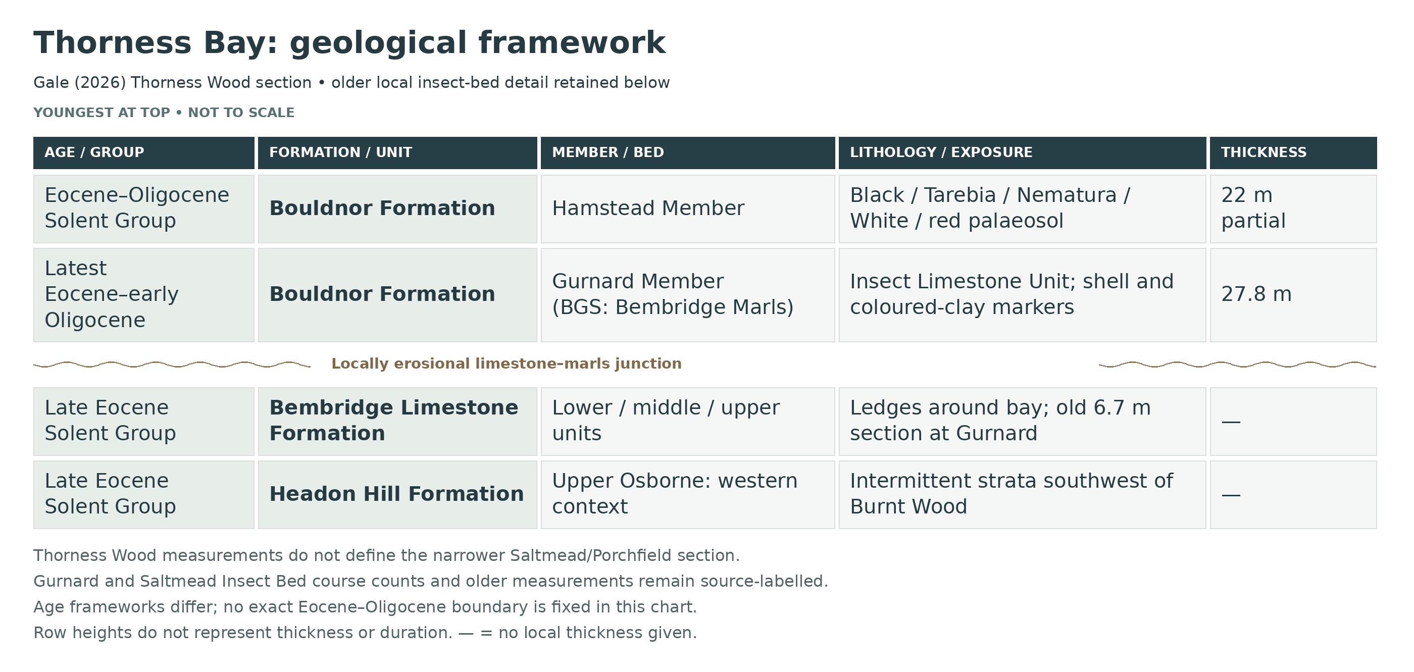
Gale (2026) documents 27.8 m of the Gurnard Member, the Bembridge Marls Member of BGS (2015), beneath Thorness Wood, together with 22 m of the overlying Hamstead Member. The local Hamstead section contains the Black Band, silt marker, Tarebia Bed, Nematura Bed, White Band and an upper red palaeosol. These are measured Thorness Wood exposures; their full thicknesses are not assigned to the narrower Saltmead/Porchfield shore.
The coast is a composite of intermittent foreshore and cliff exposures affected by beach cover, vegetation and landslip. Named local horizons and the erosional Bembridge Limestone–marls junction provide the framework for the detailed section below.

This is a detailed composite account of Thorness Bay and the adjacent Burnt Wood–Gurnard coast. The Bembridge Limestone is overlain by the Gurnard Member, termed Bembridge Marls Member in BGS (2015), and part of the Hamstead Member. Gale (2026) adds a measured 22 m local Hamstead interval to the older accounts. The insect-bearing beds, shell markers, palaeosols and the eroded limestone contact are described individually, with measurements tied to their own exposures.
Gale (2026): new Thorness Wood measured section
This account uses Gurnard Member for the unit called Bembridge Marls Member in BGS (2015). The names refer to the same member-level interval and are not stacked twice. The new measurements are from cliff and foreshore beneath Thorness Wood on the western side of the bay, not the narrower Saltmead/Porchfield collecting shore.
SOLENT GROUP
Bouldnor Formation
Gurnard Member (Bembridge Marls Member in BGS 2015)
Basal Bembridge Oyster Bed
The basal shell horizon lies on the eroded top of the Bembridge Limestone. Figure 10 shows this contact below the Insect Limestone Unit; it is a transgressive shell concentration rather than a thick imported Whitecliff sandstone.
Insect Limestone Unit
The new local log distinguishes the Insect Limestone Unit near the member base. The older Saltmead four-course and Gurnard two-course measurements retained below belong to their named exposures and must not be used as a measured thickness for every part of the Thorness Wood log.
T/P marker
The T/P marker caps the Insect Limestone Unit. Gale places it at 1.4 m in the Thorness log, on an undulating erosion surface.
Serpulid marker
The serpulid-bearing level is separately shown above T/P and below Pc in Figure 10. It forms part of the same lower-member marker succession that Gale correlates along the northwestern coast.
Pc marker
A separate Pc marker follows the serpulid horizon. The published abbreviated label is retained; it is not assigned an invented thickness or taxonomic expansion.
Green clay above Pc
A green clay interval above the Pc marker precedes the dark clay marker. The graphic log retains this coloured-clay distinction within the rhythmically bedded lower succession.
Dark clay marker
The dark clay marker is distinct from the green intervals above and below. Gale’s Figure 8F shows syneresis cracks within this Thorness marker.
Middle green-clay marker
This conspicuous green interval lies between the dark clay marker and the Potamomya horizon. The lower succession contains grey and green clays, silts, desiccation surfaces and soil-modified cycle tops.
Potamomya marker
The Potamomya-bearing marker is separately identified between the middle and upper green intervals. It is shown at 6.5 m in the Thorness log and photographed in Figure 8D.
Upper green-clay marker
A further green-clay marker above the Potamomya horizon is separately shown in Figure 10. It is not merged with the lower green beds simply because their colours are similar.
Polymesoda obovata marker
The brackish Polymesoda obovata shell marker lies above the lower coloured-clay sequence. Gale records it at 11.0–11.3 m in the Thorness section. The correlated northwestern marker rests on a burrowed omission surface.
Upper Gurnard clay cycles
The upper succession is dominated by rhythmic clays, thin dark laminated cycle bases, rooted surfaces and concretions. The member measures 27.8 m in Gale’s Thorness Wood section, rather than the 21.5 m quoted for the older Gurnard Ledge section.
Upper-member silt marker below Nystia
A silt marker containing siderite concretions occurs below the Nystia Bed in Figure 10. A further thin silt is illustrated above Nystia and beneath the Black Band. These are distinct from the lower Hamstead silt marker.
Nystia Bed
The thin brackish-gastropod horizon is retained separately near the top of the member. Gale places it at 25.7 m in the Thorness log, below the Black Band.
Hamstead Member
Black Band and basal palaeosol
The Black Band defines the base of the Hamstead Member above the rooted top of the Gurnard Member. Its base is shown at 27.8 m in the Thorness Wood section.
Lower Hamstead clays and silts
The new section documents 22 m of Hamstead Member in the back cliff of the landslip beneath Thorness Wood. This is a partial local section; it does not establish the complete Hamstead or Cranmore succession here.
Hamstead silt marker
A conspicuous silt marker lies above the Black Band and below the Tarebia Bed in Figure 10. Figure 15 correlates this lower Hamstead horizon with the other northwestern sections, while allowing lateral thickness variation.
Tarebia Bed
The Tarebia shell marker is identifiable above the silt marker and below the Nematura interval. It is well developed in the Thorness Wood exposure. The separate Log Bed with giant conifer trunks at Hamstead–Bouldnor is not imported into this local section.
Silt-filled channel beneath the Nematura Bed
At 35 m in the Thorness log, a 0.5 m silt-filled channel lies immediately beneath the Nematura Bed. This is the measured local channel fill, not proof of the Hamstead–Bouldnor Log Bed at Thorness.
Nematura Bed at Thorness
The Nematura interval is particularly thick here, measuring 3 m in Gale’s account. It lies above the silt-filled channel and is followed by mottled and partly decalcified silts and clays.
Mottled silts and clays below the White Band
The interval above the Nematura Bed and below the White Band comprises partly decalcified, mottled silts and clays. The paleosol development and discrete silt beds in Figure 10 preserve useful subdivision beyond a generic upper clay description.
White Band at Thorness
The White Band begins at 44 m in the Thorness Wood log. It includes thin mollusc-rich shell beds and discrete silt layers. This is a directly recorded local White Band occurrence, with no need to borrow the different thickness of the Hamstead log.
Upper red palaeosol marker
A brick-red palaeosol at 49.5–50 m marks the top of the available Thorness succession. Gale correlates it with the red marker above the White Band at Hamstead, within a northeastward-thinning interval. The local survey does not reach the Bouldnor Water-Lily Bed or Cranmore Member.
Published age frameworks differ. Gale (2026) revises his earlier interpretation of the basal normal-polarity interval from C13n to C15n, agreeing with King (2016). The broad chart age ranges retain that uncertainty; no exact Eocene–Oligocene boundary is identified in these local sections.
Older local bed and fossil accounts
The following older descriptive framework preserves its useful numbered beds, fossils and local thicknesses. It is a separate reference scheme; newly measured member limits above supersede any earlier impression that only the Black Band was known locally.
The TB numbers are editorial guide labels. Published GUR, THOR and BW codes refer to different measured local sections; matching Roman numbers do not automatically establish correlation. Member totals quoted for Gurnard Ledge are kept tied to that section, and the separate Saltmead/Burnt Wood Insect Bed measurements are identified by locality.
SOLENT GROUP
Headon Hill Formation (Upper Eocene / Priabonian)
Osborne Member
Bed TB1 — Upper Osborne Member (context interval)
Green, olive and red calcareous clays and lime-rich muds with discontinuous concretionary limestones are exposed intermittently south-westwards from Burnt Wood and form the highest visible part of the Headon Hill Formation in the Thorness Bay section. These beds are not the main fossil attraction here, but they are important because the overlying Bembridge Limestone rests sharply on them across much of the north-west coast. They represent shallow, fluctuating lacustrine to marginal-lagoonal mud accumulation with repeated carbonate concentration and local pedogenic modification before establishment of the more persistent Bembridge carbonate system.
Bembridge Limestone Formation (Upper Eocene / Priabonian)
The Thorness Bay–Gurnard Bembridge Limestone is not normally described with a widely used formal local bed-number scheme. The TB numbers used below are practical site-use divisions following the published threefold lithological organisation at Gurnard Ledge: a lower carbonate unit, a central muddy interval, and an upper carbonate unit. This arrangement is critical because it makes the locality much more mud-dominated than the better-known Whitecliff Bay succession.
Bed TB2 — Lower Bembridge Limestone Lower Carbonate Unit
Buff to pale grey fossiliferous limestones and marls form the lower ledges of the Bembridge Limestone at Gurnard Ledge. The rocks are mainly biomicritic and locally porous or vuggy, with rhizolith-like structures, casts of freshwater to low-salinity gastropods and bivalves, charophytes and occasional foraminiferal material. Near Gurnard Ledge, the uppermost limestone bed of this lower carbonate unit contains ferruginous chert concretions with silica pseudomorphs after gypsum, a distinctive feature apparently unique to this locality. Compared with the land-gastropod-rich limestones of places such as Prospect Quarry, the Thorness–Gurnard lower carbonate unit appears more offshore within the lacustrine–lagoonal system and less strongly palustrine.
Bed TB3 — Middle Muddy Interval (c. 3.3 m)
About 3.3 m of lime-rich muds, marls and clays separate the lower and upper carbonate units. This muddy interval is the main reason the Thorness Bay Bembridge Limestone is thinner and less limestone-dominated than the type section at Whitecliff Bay. The lowest cliff sections at Gurnard have yielded fruits and seeds from these Bembridge Limestone muds, and the broader flora of the formation here includes Azolla prisca, Sparganium multiloculare, Stratiotes neglectus, Brasenia spinosa, Potamogeton pygmaeus and Aldrovanda intermedia, together with charophytes in the upper limestone and rare rodent gnaw marks on Stratiotes seeds. This interval represents low-energy lime-rich mud accumulation in calcareous ponds or lakes with open water and emergent vegetation.
Bed TB4 — Upper Bembridge Limestone Upper Carbonate Unit And Erosive Top
Buff limestones and marls form the upper carbonate unit, but its lithology varies laterally south-westwards, in part because of contemporaneous erosion before deposition of the overlying marls. The top of the Bembridge Limestone here is therefore not simply a neat conformable bedding plane: at Thorness Bay the contact with the Bembridge Marls is locally unconformable and records intra-Palaeogene uplift and warping along the Porchfield Anticline. The upper unit completes a 6.7 m formation at Gurnard Ledge and provides the irregular, locally omission-prone substrate on which the Bembridge Marls accumulated.
Total Thickness Of Bembridge Limestone Formation At Gurnard Ledge: 6.7 Metres
Bouldnor Formation (Latest Eocene To Earliest Oligocene)
Bembridge Marls Member
Published local horizon codes such as BW I, BW IV, THOR III and GUR IX are retained below where they are geologically important. The TB numbers used alongside them are broader site-use identifiers for practical website description and are not intended to replace the formal local horizon terminology developed for Thorness Bay and Gurnard. At Gurnard Ledge, the member is 21.5 m thick and is composed mainly of black, grey and green muds and marls with shell seams, lime-mudstones and the famous Bembridge Insect Bed low in the succession.
Bed TB5 — Basal Shell-Band Interval And BW I Algal Horizon
The Bembridge Marls rest on an erosional and omission-prone surface cut into the Bembridge Limestone. Unlike Whitecliff Bay, there is no thick basal sandy Bembridge Oyster Bed here, but two oyster-bearing shell bands occur near the base. At Burnt Wood, the bottom bed of the member, BW I, has yielded small stromatolitic or oncolitic algae, apparently the only such fossils recorded from the Palaeogene of southern England. Lithologically the interval consists of black, grey and green muds and marls with shell seams and local lime-mudstone, recording the first flooding of the irregular limestone surface by shallow brackish water, still quiet enough for delicate sedimentation but intermittently agitated enough to concentrate shells.
Bed TB6 — Lower Brackish Marl And Life-Position Bivalve Interval, Including THOR III
Grey and blue-green clays with shell seams dominate the lower part of the member above the basal shell bands. Numerous shallow-burrowing bivalves occur in life position towards the base of the succession, showing that much of the substrate remained undisturbed for long periods. On the southern limb of the syncline, west of Pilgrims Park, bed THOR III yielded the shell-encrusting alga Epivalvia edwardsii. Shell preservation varies strongly with lithology: the best material comes from grey clays, whereas shells in blue-green clays are commonly chalky, friable or decalcified. Environmentally this interval represents a quiet brackish to freshwater lagoonal and marsh-waterbody setting with fluctuating salinity.
Bed TB7 — Bembridge Insect Bed / GUR IV = BW IV (whole bed commonly c. 0.65–0.85 m; tabular limestone often c. 0.1 m in the GCR account)
This is the celebrated Thorness–Gurnard insect and plant horizon, near the member base; the local basal beds beneath its lower shell band measure 0.50–0.65 m at Saltmead and 0.66–0.82 m at Gurnard in Jarzembowski’s figures. It is better treated as a broader Bembridge Insect Bed than as a single “Insect Limestone”, because the bed is predominantly argillaceous and includes discontinuous concretionary limestones and hard marls as well as a more or less tabular micritic limestone. At Gurnard the whole bed is commonly about 0.65–0.75 m thick and consists of a lower, more or less continuous limestone with upper discontinuous concretions; at Saltmead Ledge on the opposite limb it is about 0.65–0.85 m thick and divided into four calcareous courses. Fresh rock is blue-grey and exceptionally fine grained, weathering with a brownish rind, and contains thin silty laminae rich in carbonaceous detritus, ostracods, plant fragments—especially Typha—and insect debris. This is one of the richest units in the British Tertiary for its thickness: more than 200 insect species, spiders, anostracan and isopod crustaceans, ostracods, rare bird feathers and the main source of the Bembridge flora have all come from this level. Molluscs include freshwater hard-water forms such as Lymnaea (Galba) longiscata, Planorbarius discus, Gyraulus similis, Hippeutis headonensis, Viviparus lentus and V. angulosus, together with the more brackish Tarebia acuta and Polymesoda obovata. The flora includes delicate fruits and seeds with wings and plumes, Typha, aquatic plants and whole Azolla plants. Taken together, the sedimentology and fauna suggest an exceptionally quiet shallow depocentre within a marsh–lagoon complex, probably fresh to slightly brackish, into which some shells and plant fragments were washed.
Individual calcareous courses in the older local logs
These descriptions follow Jarzembowski’s figures from field observations in 1976–77. The two named local sections are kept separate; no course-specific fossil list or scale-derived thickness is added.
Saltmead BW IV: lower nodular course
Jarzembowski’s 1976–77 Saltmead observations distinguish a lowermost nodular calcareous course within the laminated marly-clay Insect Bed. It lies above the BW III shell band. Its course thickness is not read from the drawing’s scale.
Saltmead BW IV: second limestone and hard-marl course
The next calcareous course contains limestone and hard marl, separated from the lower nodular development by more argillaceous sediment. It remains one course within BW IV, not a separately named formal bed.
Saltmead BW IV: very thin third hard-marl course
A particularly thin hard-marl course is individually shown above the second course. Its separate position is retained without inventing a numerical thickness or a diagnostic fossil assemblage.
Saltmead BW IV: upper large-concretion course
The upper course consists of comparatively large, discontinuous limestone concretions within the marly-clay interval below BW V. The four-course Saltmead architecture is a historical exact-locality observation, not a four-bed template imposed on every Insect Limestone exposure.
Gurnard GUR IV: lower limestone course
Jarzembowski’s 1976–77 Gurnard log shows a lower, relatively continuous limestone course within the 0.65–0.75 m whole Insect Bed. That whole-bed range does not measure this lower course alone.
Gurnard GUR IV: upper concretionary course
A separate upper course comprises discontinuous concretions in the clay-rich interval. These two Gurnard courses differ from the four-course Saltmead development. No one-to-one numerical matching of individual courses, or distinct course-specific insect fauna, is established.
Bed TB8 — Lower–Middle Bembridge Marls With The Serpulid Marker GUR IX
Above the Insect Bed, black, grey and green marls and muds continue with thin shell seams and locally calcareous bands. Bed GUR IX is a very thin serpulid-rich marker horizon that can be traced widely wherever the lower part of the member is visible, including at localities many kilometres away. The interval as a whole shows how even very thin faunal beds could become regionally persistent. Some coquinas and convex-upward bivalve concentrations indicate short episodes of water movement, but the dominant impression is of prolonged quiescence, supported by varve-like lamination and undisturbed mud accumulation.
Bed TB9 — Middle–Upper Shell-Bearing Marls, Including Corbicula And Nystia Horizons
The middle to upper part of the Bembridge Marls at Gurnard Ledge includes additional shell-rich intervals recognised in the classic local log, among them a corbiculid-rich bed in the middle to upper member and a higher Nystia-bearing band close to the top. Grey clays again provide the best shell preservation. These beds record repeated oscillations between brackish lagoon, fresher marsh pool and shallow standing-water conditions. Outside the main Insect Bed, other plant-bearing horizons in the member have yielded aquatic fruits and seeds such as Rhamnospermum bilobatum, Stratiotes neglectus and Sabrenia chandlerae, showing that open-water and marsh vegetation remained widespread through much of the succession.
Older Gurnard Ledge comparison within the wider bay
The following markers belong specifically to the Gurnard Ledge graphic in GCR Figure 5.45. They enrich the northern-shore comparison above and are not measured Thorness Wood or Saltmead beds, nor a numerical crosswalk to Gale’s new Thorness log.
GUR XV — Separate shell horizon
Figure 5.45 shows a shell-bearing level at XV below the laminated XVI–XVII interval. It is retained as a distinct molluscan concentration without supplying a species list or a scale-derived thickness.
GUR XVI–XVII — Laminated interval
The interval between the XV and XVIII shell levels is separately shown with fine sedimentary lamination. It is not merged into one structureless clay package.
GUR XVIII — Shell horizon above the laminated beds
A further shell-bearing level at XVIII caps the preceding laminated interval. Its position distinguishes it from XV below and the later shell concentrations higher in the member.
GUR XX — Laminated lower part
The numbered XX package includes a laminated lower interval above XIX. The figure does not establish an independent thickness or formal bed name for that laminated component.
GUR XXII — Shell horizon
The shell-bearing XXII level lies above XXI and below the thicker XXIII mud interval that precedes the Corbicula Bed. Its fauna is not automatically equated with that named higher shell bed.
GUR XXVI — Shell horizon above the Corbicula interval
A separate shell concentration at XXVI follows the intervening XXV muds above the Corbicula Bed at XXIV. Several shell incursions are therefore represented, not one continuous corbiculid band.
GUR XXVII — Laminated and rooted upper part
The upper part of the XXVII clay package is laminated and rooted beneath the dark lignitic band. These contacts record a change within the older log rather than an inferred new formation boundary.
GUR XXVIII–XXIX — Lignitic band and overlying clay
The conspicuous dark lignitic level at XXVIII overlies the rooted top of XXVII and is followed by the XXIX clay interval. The approximately 3 m non-exposure gap lies above this package in the published log; it is not filled with invented lithologies.
GUR XXX–XXXII — Clay package with dark seams
Above the larger exposure gap, Figure 5.45 shows clays numbered XXX–XXXI with a dark seam at their junction and another dark boundary near XXXII. A separate non-exposure gap of about 0.5 m follows below the Nystia-bearing highest package.
GUR XXXIV — Clay above the Nystia Band
The Nystia shell marker at XXXIII is followed by the XXXIV clay interval. No direct equivalence with a particular Gale cycle is imposed.
GUR XXXV — Separate hard band
A distinct hard band is shown in the upper part of the old graphical log at XXXV. Its independent position is retained without naming an unverified mineral composition or calculating a thickness from the illustration.
GUR XXXVI — Laminated upper interval
The laminated XXXVI interval lies above the separate hard band. It provides another visible sedimentary subdivision near the top of the old Gurnard Ledge log.
GUR XXXVII — Rooted top
The uppermost numbered interval bears roots beneath the Hamstead Member. This rooted contact is distinct from the lower lignitic and rooted levels and is preserved as part of the old graphic scheme.
Bed TB10 — Upper Bembridge Marls And Rooted Top Surface
The upper part of the member is commonly obscured by vegetation and cliff deterioration, but the classical succession continues upward through varicoloured muds and silts with shell seams into a rooted top surface below the Black Band. Mud cracks and pyrite “pins” indicate very shallow water and rooted herbaceous vegetation, and the broader Thorness Bay palaeobotanical evidence suggests extensive persistent marshland with some open waters, some fluvial influence and locally small wooded “tree islands”. The uppermost Bembridge Marls pass into an omission surface and palaeosol rather than a simple uninterrupted bedding transition.
Total Thickness Of Bembridge Marls Member At Gurnard Ledge: 21.5 Metres
Hamstead Member
Bed TB11 — Black Band And Basal Hamstead Omission Surface (c. 0.4 m; poorly exposed)
Poor exposures of the Black Band occur just south of Gurnard Ledge. Where visible, it is a dark brown to black shelly organic-rich clay about 0.4 m thick, locally with scattered angular flint pebbles, resting on a rooted palaeosol with calcrete-like concretions developed at the top of the Bembridge Marls. It contains a freshwater fauna and flora and forms the defining basal marker of the Hamstead Member. At Thorness Bay it is more important as a stratigraphic datum than as a productive fossil bed because exposures are usually poor and intermittent.
Structural Style And Composite Nature
Thorness Bay must be treated as a composite section assembled from Burnt Wood, Saltmead Ledge, the southern limb west of Pilgrims Park, the cliffs south of Gurnard and Gurnard Ledge. The beds occur on both limbs of the shallow Thorness Bay Syncline and are not exposed as one simple uninterrupted face. The locally unconformable base of the Bembridge Marls on the Bembridge Limestone, together with the south-westward variation and partial erosion of the upper limestone unit, was one of the key pieces of evidence used to demonstrate intra-Palaeogene warping along the Porchfield Anticline. In field terms, that means marker beds are more reliable than any attempt to force the locality into a single uniform vertical log.
Depositional Environment
The upper Osborne Member represents calcareous mud accumulation in shallow lagoonal to lacustrine settings. The Bembridge Limestone formed in warm, clear, calcareous ponds or lakes with open water and emergent vegetation in relatively dry surroundings. The Bembridge Marls then record a broader and more persistent brackish-to-freshwater marshland and lagoon system with sluggish rivers, open pools and salinity fluctuations; the Insect Bed formed in one exceptionally fine-grained quiet-water depocentre within that system; and the Black Band marks renewed organic accumulation above a rooted omission surface at the base of the Hamstead Member.
Stratigraphic And Palaeontological Significance
Thorness Bay is one of the most important British late Eocene coastal sites because it combines the main source of the Bembridge flora with the classic Bembridge Insect Bed. The flora exceeds 100 species, many unique to the site, and the insect assemblage is the largest known from the British Tertiary. Together they provide one of the best windows into ecological and climatic change around the Eocene–Oligocene transition in north-west Europe, while the sedimentary relationships between the Bembridge Limestone and Bembridge Marls also make the locality important for understanding intra-Palaeogene earth movements on the Isle of Wight.
Total Thickness Covered Here
The older GCR composite concentrated on the 6.7 m Bembridge Limestone and 21.5 m Bembridge Marls at Gurnard Ledge, plus the basal Black Band. Those figures describe the earlier framework; they no longer delimit all strata documented around Thorness Bay. Gale’s separate Thorness Wood log records 27.8 m of Gurnard Member and 22 m of partial Hamstead Member. They are not added to the Gurnard Ledge thicknesses to manufacture a whole-bay total.
References
Reid, C. & Chandler, M.E.J. (1926). The Bembridge Flora.
Daley, B. (1972, 1973, 1974, 1989, 1999) on the Thorness Bay and Gurnard stratigraphy, Bembridge Marls faunas, algal horizons and Isle of Wight Palaeogene sections.
Daley, B. & Edwards, N. (1971, 1990) on intra-Palaeogene warping and the Bembridge Limestone succession.
Insole, A. & Daley, B. (1985). Revision of the late Eocene and early Oligocene lithostratigraphy of the Hampshire Basin.
Collinson, M.E., Hooker, J.J. and co-authors (1983, 1987, 1993, 2000) on the Bembridge flora, palaeoecology and rodent gnaw marks.
Jarzembowski, E.A. (1980a, 1980b) on the Bembridge Insect Bed insect fauna and field sections.
Munt, M.C. (2014). Molluscs from the Insect Limestone of the Bembridge Marls Member.
British Geological Survey memoir: Geology of the Isle of Wight, and BGS Lexicon entries for Osborne Member, Bembridge Limestone Formation, Bembridge Marls Member and Hamstead Member.
JNCC Geological Conservation Review accounts for Thorness Bay and for Thorness Bay and Gurnard.
Checked sources: Hopson and Farrant (2015), Isle of Wight, Solent Group; Daley and Balson (1999), GCR15: Thorness Bay and Gurnard, Figures5.43–5.45; Cleal and colleagues (2001), GCR22: Thorness Bay; Jarzembowski (1980), Fossil insects from the Bembridge Marls, pp.240–243, Figs2–3; Ross and Self (2014), The fauna and flora of the Insect Limestone: introduction, history and geology.
Additional source: Gale (2026), Bouldnor Formation stratigraphy, section 3, Figures 10, 14–16.
EQUIPMENT
Most fossils at Thorness Bay can be collected simply by searching the foreshore, without the need for heavy tools.
A small hammer, pick and safety glasses may be useful for carefully splitting any blocks from the Bembridge Insect Bed, particularly where finely laminated limestone is present. Because these fossils can be extremely delicate, splitting should always be done slowly and carefully.
If collecting samples from the softer marls for sieving at home, a small trowel and sample bags or containers are recommended.
It is also advisable to bring tissue or wrapping material, as insect-bearing slabs, turtle shell fragments and other fossils can be fragile and easily damaged during transport.
CLEANING AND TREATING
Keep insect-bearing slabs supported and retain both matching split faces. Begin with minimal dry cleaning; do not scrub delicate impressions or routinely soak laminated marl, clay-rich slabs or pyritic material. Seek preparation advice before desalinating fragile specimens.
Use Paraloid B-72 only if a specimen needs consolidation, after testing and preferably with specialist advice. It can be re-dissolved in suitable solvents, but removing a treatment from porous fossils is not always straightforward. Record any treatment; a surface coating does not prevent pyrite decay.
Do not apply varnish to insect-bearing slabs, plant impressions or potentially significant vertebrate remains. Keep the locality and horizon information with each specimen, and ask a museum or experienced preparator before working on unusual or especially fragile material.
IDENTIFY YOUR FINDS
Need help identifying a fossil? Share clear photos, where you found it and its size with the community.
FURTHER READING
GCR / GeoGuide – Thorness Bay and Gurnard, Isle of Wight
GCR / GeoGuide – Thorness Bay — fossil plants
UCL research paper – Vertebrate remains from the Insect Limestone (latest Eocene), Isle of Wight, UK (wider Insect Limestone outcrop; PDF)
British Geological Survey – Geology of the Isle of Wight (island-wide geological context)
SAFETY
Common sense should always be used when collecting, and checking tide times before visiting is essential. The sea can reach the base of the cliffs at high tide, so ensure you leave plenty of time to return safely before the tide turns.
Avoid the soft mud flats and keep well clear of cliff edges, cliff bases and landslips. If there is no firm beach route with room to stay clear of the cliffs, turn back. In a coastal emergency, call 999 and ask for the Coastguard.
The cliffs are low but often heavily slipped and unstable in places, particularly after wet weather, so care should be taken around recently eroded sections and fallen material.
ACCESS RIGHTS
This coast forms part of Thorness Bay SSSI. Respect landowner access conditions and local notices. Keep casual collecting to loose beach material; do not hammer the bedrock or dig into the cliffs. The Natural England citation for Thorness Bay SSSI explains the protected scientific interest.
It is important to follow our ‘Code of Conduct’ when collecting fossils or visiting any site. Please also read our ‘Terms and Conditions‘
LINKS
♦ Fossil Discussions
♦ Fossil Articles
♦ Buy Fossils, Tools and Equipment
♦ Buy Crystals, Meteorites, and Artefacts
♦ Join Fossil Hunts
♦ UK Fossils Network