White Nothe, between Ringstead and Lulworth Cove, is a dramatic and lesser-visited section of the Jurassic Coast World Heritage Site. This steep headland exposes a mix of Jurassic and Cretaceous rocks, with landslips bringing fossil-bearing material onto the foreshore. Although challenging to access, it can yield ammonites and other marine fossils under the right conditions, making it a rewarding location for experienced collectors seeking quieter ground.


FIND FREQUENCY: ♦♦♦♦ – White Nothe is a location that is not often visited by fossil hunters, so there is often plenty to be found, especially after a high tide and /or storms. However, you really need the right conditions for any decent finds.
CHILDREN: ♦♦ – This location is probably not suitable for younger children because of the long walk from Ringstead Bay and the rocky foreshore.
ACCESS: ♦♦ – It is a long walk down to the beach and the rocky foreshore can be quite difficult. The car park is easy to find, being next to the Beach Cafe (clearly signposted from the A353).
TYPE: Most of the fossils can be found on the foreshore, especially after storms, but fossils are also commonly found in fallen blocks of Chalk or Upper Greensand on the beach.
DIRECTIONS
♦ Access is best from Ringstead Bay, (clearly signposted), with easy parking and a beach cafe and then by walking east along the beach.
♦ The car park can be accessed from the toll road off the A353 to Ringstead. Follow the road and take a sharp right at the top of the hill. It will then take you to the low cliff where you will need to walk east. Ringstead is to the south of Poxwell.
♦ There is a daily rate charge at the car park (April to November) and the beach café/shop is open during the summer season, with toilets close by.
♦ What3Words: ///skinny.snippets.whirlpool
♦ Postcode: DT2 8NG, Google Maps Link.
VIDEO FILM
FOSSIL HUNTING
The foreshore at White Nothe is highly productive for fossil hunting, with a wide range of well-preserved marine fossils derived from the Chalk and the Upper Greensand. Much of the material is found loose on the beach, weathered out of fallen blocks or washed free during periods of strong tidal action, meaning careful searching rather than excavation is usually all that is required.
Echinoids are characteristic Chalk fossils at White Nothe, but different horizons contain different assemblages. Holaster subglobosus is particularly associated with the condensed Cenomanian deposits and basal Zig Zag Chalk. In the higher Chalk, the documented local markers include Micraster leskei around the Lewes Marl and Micraster normanniae around the Navigation Hardgrounds. Echinocorys and regular echinoids also occur, together with detached spines and broken tests. A loose specimen may have travelled from a fallen block, so record its matrix and finding position rather than assigning it to a bed from its position on the beach.
Large ammonite fragments and occasional more complete specimens can occur in loose Chalk blocks. Published White Nothe records include Acanthoceras, Calycoceras, Schloenbachia and Scaphites in the condensed Cenomanian succession; the modern composite also records Mantelliceras in the Chalk Basement Bed. Some fossils are reworked, and a large ammonite should not be assigned to Pachydiscus or Lewesiceras from size alone. Identification needs the preserved whorl shape, ribs, sutures where visible, and matrix. Look only in permitted loose material on firm, open foreshore, well clear of cliff bases, fresh falls and slipped ground, after storms have passed and safe conditions have returned.
Brachiopods are another frequent Chalk fossil and are often found as both single valves and paired shells. Typical examples include Terebratulina, Gibbithyris and Cretirhynchia, which can show excellent surface detail when well preserved. Bivalves are also widespread and are commonly encountered as isolated valves or shell fragments, with Inoceramus being particularly distinctive due to its thick, often ribbed shell fragments. Other bivalves such as Ostrea, Spondylus and Pecten are also regularly found. Additional Chalk fossils include small crinoid columnals, usually appearing as short, disc-shaped segments, along with occasional fish remains such as isolated teeth or bone fragments for those prepared to search carefully.
The Upper Greensand at White Nothe is especially rich in fossil material and produces some of the most diverse and finely preserved specimens from the area. Fossils are often found in fallen blocks or on freshly exposed bedding planes, and the preservation quality can be exceptional when material has not been exposed for long periods. Brachiopods are particularly abundant, with a wide range of species present, including Rhynchonella, Terebratula, Crania and Kingena, many of which retain sharp ribbing and fine shell detail.
Bivalves are also very common in the Greensand and can often be collected in large numbers when conditions are favourable. Typical finds include Exogyra, Pecten, Lima, Trigonia and Gryphaea, with some specimens showing minimal abrasion and excellent preservation. Gastropods are also present and can be particularly rewarding to collect when the Greensand is freshly exposed, as the matrix is initially soft and easy to work. Genera such as Turritella, Natica, Pleurotomaria and Cerithium may be encountered, often preserved with delicate surface ornamentation. Do not approach fresh falls or slipped ground to reach soft material; search only permitted loose pieces on firm, open foreshore, clear of the cliffs.
During periods of strong scouring tides, large numbers of loose molluscs from the Greensand can be washed free and left on the foreshore, sometimes in near-perfect condition. Other fossils found within the Greensand include serpulid worm tubes attached to shells or rock surfaces, crinoid fragments and occasional small echinoids, which tend to be more delicate than their Chalk counterparts.


Some of the most significant fossil and scientific milestones from White Nothe include the early description of the Upper Cretaceous succession, classic work on the Chalk zones, the recognition of condensed Cenomanian deposits and overstep, and later studies that established White Nothe as one of the key Dorset sections for lateral changes in Chalk facies and fossil assemblages.
1876 – Barrois published one of the first major accounts of the Upper Cretaceous at White Nothe
Charles Barrois included White Nothe in his classic work on the Upper Cretaceous of England and Ireland. This early study helped establish the importance of the White Nothe cliffs for understanding the Chalk succession of Dorset and its relationship to other parts of southern England.
1901 – A. W. Rowe produced the classic zonal account of the Dorset White Chalk, including White Nothe
Arthur Wade Rowe’s work on the zones of the White Chalk of the English coast made White Nothe one of the important Dorset sections for Chalk biostratigraphy. His study helped place the exposed succession into the wider framework of Upper Cretaceous fossil zones used around the English coast.
1904 – Jukes-Browne and Hill included White Nothe in the classic Geological Survey account of the Cretaceous rocks of Britain
The great Geological Survey memoir on the Upper Chalk of England helped cement White Nothe as one of the standard Dorset coastal sections. This work contributed to the long scientific tradition of using White Nothe as a reference point in the Chalk succession.
1967 – Drummond clarified the Cenomanian palaeogeography of Dorset and the importance of White Nothe
P. V. O. Drummond’s work on Cenomanian palaeogeography showed that White Nothe is especially important for understanding condensed Chalk successions on the margin of the basin. His research helped explain the rapid overstep of the Chalk and the erosion beneath it in this part of Dorset.
1970 – the Mid-Dorset Swell concept highlighted White Nothe as part of an important tectonic and sedimentary transition zone
Drummond’s later work on the Mid-Dorset Swell reinforced the importance of White Nothe in showing how Albian and Cenomanian earth movements affected sedimentation. This made the locality significant not only for fossils, but also for reconstructing the tectonic history of the Dorset Chalk margin.
1987 – Mortimore and Pomerol published part of the White Nothe Chalk section
Their study included the Turonian–Santonian succession at White Nothe and published part of its measured section. It helped correlate local marl seams, flints and erosional surfaces with other Chalk sections. The earlier 1979 work cited by the GCR concerns a related erosional succession at Mupe Bay and should not be presented as a separate White Nothe measured log.
1996 – Gale used White Nothe in Turonian correlation and sequence stratigraphy of the Chalk
Later sequence-stratigraphic work showed that White Nothe is an important transitional section for correlating the Dorset Chalk with other successions in southern England. This helped reinforce the value of the site for tracing key marker beds, marl seams and fossil events through the Chalk.
1997 – Bristow, Mortimore and Wood formalised the Chalk lithostratigraphy used to map the White Nothe succession
Modern lithostratigraphic work provided the framework used for mapping the Chalk formations exposed at White Nothe, including the Zig Zag Chalk, Lewes Nodular Chalk, Seaford Chalk, Newhaven Chalk and Culver Chalk. This gave White Nothe an important place in the modern geological mapping of the Dorset coast.
2017 – Gallois and Owen defined the White Nothe Member
Their Upper Greensand study named the condensed upper member and published an eighteen-bed local composite, with separate nearby sections showing lateral changes. This provides the detailed Albian framework used below.
Modern understanding – White Nothe is recognised as a key section for Chalk overstep, condensation and faunal change
Modern reviews recognise White Nothe as one of the most important Dorset sections for showing how Upper Cretaceous sediments and fossil assemblages change towards the margin of the basin. The site is particularly important for the condensed Cenomanian succession, the sub-Chalk erosion surface, and the way fossil abundances differ from the main basin farther east, with Holaster especially common in the Upper Cenomanian and regular echinoids more common in the Upper Turonian.
GEOLOGY
White Nothe forms a prominent headland rising to approximately 160 metres and marks the eastern end of Ringstead Bay. The cliffs here provide an impressive and near-vertical exposure of Cretaceous strata, dominated by the Chalk Group, with excellent sections through both the Grey Chalk Subgroup, formerly known as the Lower Chalk, and the White Chalk Subgroup, previously referred to as the Middle and Upper Chalk. This makes White Nothe one of the most visually striking and geologically important cliff sections along this part of the Dorset coast.
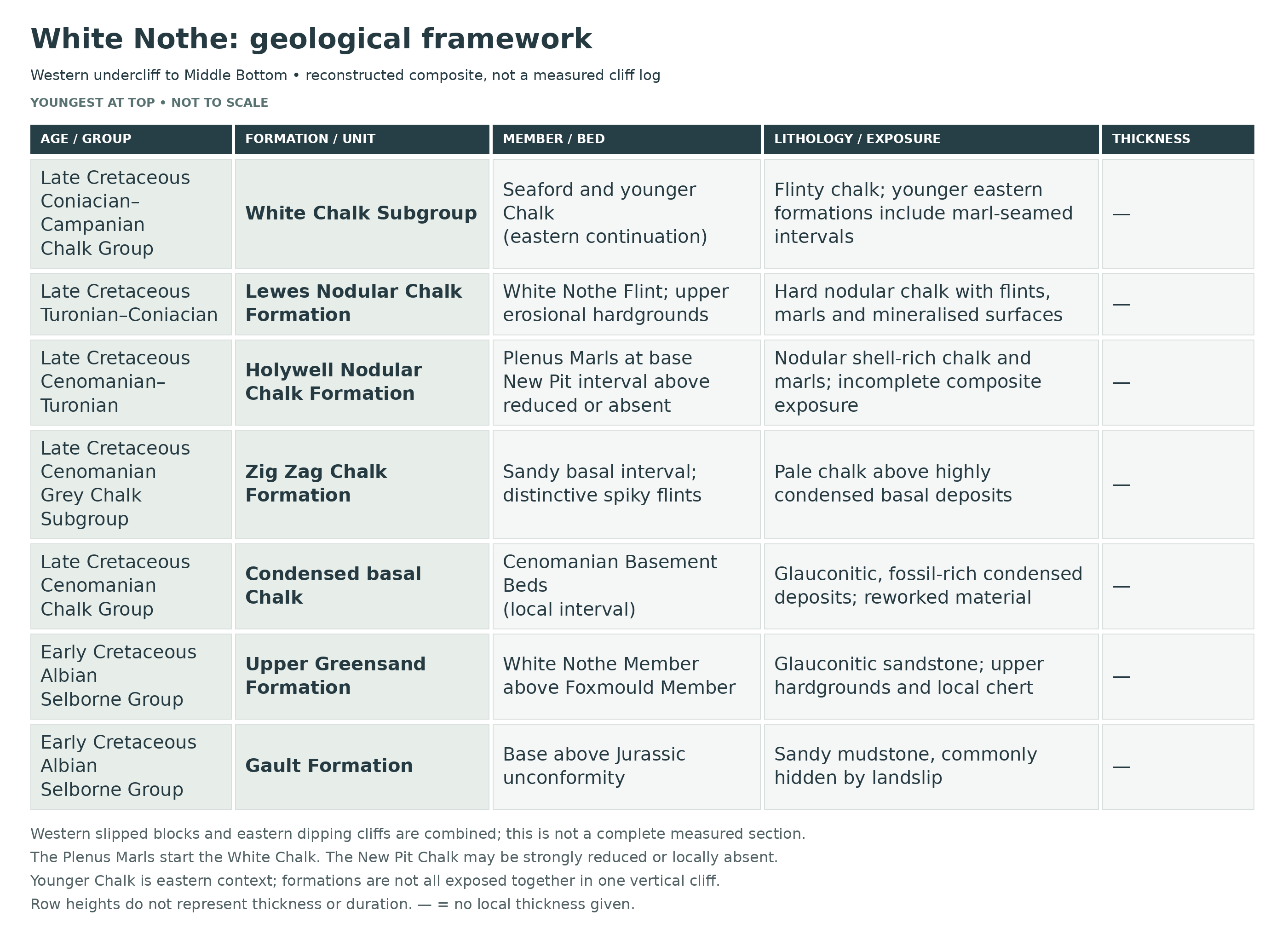
Southeast of Holworth House, Gault, Upper Greensand and Chalk occur in a structurally complex coastal section. The western undercliff contains rotated landslip blocks in front of steep Chalk faces; farther east, folding and faulting affect the cliffs towards Middle Bottom. These relationships must not be read as one simple, uninterrupted vertical succession.
The Grey Chalk Subgroup is condensed at White Nothe. Thin, fossil-rich Cenomanian Basement Beds are followed by the Zig Zag Chalk Formation, whose lower part includes a sandy interval and distinctive spiky flints formed in crustacean burrows. This differs from the more expanded, rhythmically bedded West Melbury Marly Chalk succession farther east. Fallen blocks and intermittent exposures are used to reconstruct the local sequence.
The condensed Basement Beds contain ammonites, echinoids and reworked fossils. Higher in the succession, the Plenus Marls Member lies at the base of the Holywell Nodular Chalk Formation and therefore marks the beginning of the White Chalk Subgroup, not the top of the Grey Chalk Subgroup. The overlying New Pit Chalk interval may be much reduced or locally absent.
Above this, the upper portion of the cliff is formed by the White Chalk Subgroup, including the Lewes Nodular Chalk and the Seaford Chalk formations. Initially, the chalk beds are near-horizontal, but moving eastward they begin to dip progressively, first gently and then more steeply, towards a syncline at Middle Bottom. This eastern section of the cliff is inaccessible on foot, and access to the next bay is not possible without a boat due to the steepness and instability of the cliffs.
At beach level, both the Chalk and the Upper Greensand are exposed in places. The Upper Greensand includes both weakly cemented sands and hard calcareous sandstone, calcarenite and chert-bearing beds; softness varies with lithology and weathering. Only where permitted, suitable loose blocks on firm, open foreshore may be examined with hand tools; remain well clear of cliff bases, fresh falls and slipped ground. The Upper Greensand is also exposed at the very tip of White Nothe during low tide, though access is dependent on sea conditions.
Upper Greensand fossils occur in loose beach material, but do not search at landslide bases or beneath the cliffs. Keep to firm, open foreshore with a clear return route; the Smuggler’s Path and any ladder must not be relied upon as an emergency escape from the tide. However, much of the exposure is obscured by slumped material and landslide debris. The extensive undercliff conceals much of the succession beneath rubble and slipped blocks. The major Cretaceous overstep is where the Gault rests on Jurassic rocks; the Gault–Upper Greensand passage is transitional, while the base of the Chalk is a separate erosional, mineralised surface. These contacts must not be merged into one unconformity.

This is a composite stratigraphic breakdown of the White Nothe coastal section, Dorset, where Albian to Campanian strata are exposed in landslipped cliffs, fallen blocks and foreshore sections rather than in one simple continuous cliff log. The locality is important because it shows the westward Cretaceous overstep onto older Jurassic rocks, preserves the hardground-rich White Nothe Member of the Upper Greensand in exceptional detail, and provides one of the key Dorset reference sections for the lower to middle parts of the Chalk succession.
Bed WN1 — Jurassic Substrate And White Nothe Unconformity (context interval)
White Nothe must be treated as a composite structural locality, not as a single uninterrupted measured face. West of the headland and around Holworth House, Gault and Upper Greensand rest with marked unconformity on steeply dipping Portland Stone and Portland Sand, Purbeck lagoonal and peritidal strata, and locally the highest Kimmeridge Clay marine mudstone; the relationship is further complicated by the Holworth House Fault and by widespread landslip, so the Jurassic rocks are best regarded here as the faulted substrate beneath the Cretaceous overstep rather than as a continuous bed-by-bed foreshore log. On this page, the WN numbers used outside the White Nothe Member are site-use identifiers for major local lithological intervals; only Beds 1–18 below are formal published bed numbers.
SELBORNE GROUP
Gault Formation
Bed WN2 — Gault Formation (c. 12.5 m in the classic White Nothe measurement)
Strahan measured about 12.5 m of sandy clays and clayey sands at the base of the Cretaceous succession here. Lithologically the Gault is a pale- to dark-grey and locally blue-grey sandy mudstone/clay unit, glauconitic in part and originally containing phosphatic and pyritic nodules, but it is now usually poorly exposed because montmorillonite-rich beds fail easily and generate the undercliff. Its significance at White Nothe is stratigraphic rather than scenic: it records the marine flooding across an eroded Jurassic surface, and Gallois and Owen (2017) discuss regional Middle Albian ammonites of the spathi, intermedius and nitidus subzones from Purbeck and Osmington. Much of that material is loose or lacks an exact bed provenance; it is not an in-situ White Nothe assemblage that dates each local Gault bed. Poor exposure, slumping and limited fossil control leave the detailed local age assignments uncertain.
Upper Greensand Formation
Foxmould Member
Bed WN3 — Lower To Middle Foxmould Sandstones (most of the c. 30 m Foxmould succession)
The lower part of the Upper Greensand in the Isle of Purbeck is the Foxmould, a succession of fine-grained glauconitic sandstones with tabular calcareous beds and ovoid cementstones. At White Nothe the bulk of its c. 30 m thickness is concealed by landslip, but the member originally comprised weakly calcareously cemented green sands that coarsen upward from the Gault and become increasingly bioturbated and shelly higher in the section. The wider Foxmould fauna indicates late Albian ages from the orbignyi and binum ammonite subzones upward into the choffati–early auritus transitional interval, and White Nothe is one of the key Dorset localities showing how this sandy shelf succession was thinned and condensed on the Mid-Dorset Swell. Indigenous crushed Callihoplites have been recorded about 2 m below the Exogyra Rock, showing that fossiliferous late Albian beds persist high in the Foxmould even where exposure is poor.
Bed WN4 — Exogyra Rock (upper Foxmould interval; c. 2.95–3.15 m)
The uppermost Foxmould at White Nothe is the classic Exogyra Rock. The lowest c. 0.9 m is a glauconitic sandstone with patchy dense calcareous cement and traces of cross-bedding; above this lies c. 1.6–1.8 m of highly bioturbated green sandstone with calcareously cemented Thalassinoides, oysters and serpulids, commonly concentrated at the base on an irregular surface; the upper c. 0.45 m is a bioturbated calcareous glauconitic sandy limestone/sandstone with nodular texture and abundant Amphidonte obliquata (the old Exogyra conica of older literature), Rhynchostreon columba, Neithea fragments and serpulids. This is one of the most fossiliferous and collector-relevant Albian horizons at White Nothe and represents a shallow marine oyster-rich firmground immediately below the far more condensed White Nothe Member.
Lower Exogyra Rock Subdivision — Approximately 0.90 m
Gallois and Owen describe the lower subdivision as glauconitic sandstone with irregular dense carbonate cement, nodular texture, strong bioturbation and traces of cross-bedding. The lower limit of abundant oysters lies within it.
Middle Exogyra Rock Subdivision — Approximately 1.60–1.80 m
The middle green to dark-green sandstone is strongly burrowed, with carbonate-cemented Thalassinoides and other burrows. An oyster concentration at its irregular base is distinct from the upper sandy-limestone unit.
Upper Exogyra Rock Subdivision — Approximately 0.45 m
The top fine sandstone and sandy limestone is calcareous, glauconitic and strongly burrowed. The 2017 local account records abundant oysters, with pectinid and serpulid material. These three source-scoped intervals form the stated approximately 2.95–3.15 m package; they are not arbitrary new formal beds.
White Nothe Member
The following eighteen beds and their centimetre-to-metre ranges come from Gallois and Owen’s White Nothe composite, based mainly on the in-situ sea cliff at [SY 7712 8065]. The authors explicitly describe lateral variability between the sea cliff and western exposures, with some hardground contacts locally sheared out. The ranges are preserved as published local observations, not converted into a single ideal complete column.
Published Bed Numbering Used Below
Beds 1–18 below are the published bed numbers of the White Nothe composite section used by Gallois & Owen for the highest Upper Greensand; they are not a website renumbering. The member, formerly included in the local ‘Chert Beds’, consists of laterally variable calcareous sandstones, sandy calcarenites and highly glauconitic sandstones separated by up to eight erosional hardgrounds, some locally sheared out. In the modern log all sandstones are fine-grained and glauconitic unless otherwise stated, and fresh colours range from dark green in the most argillaceous beds to faintly green-tinged off-white in the hardest calcarenites. Fossils are less diverse than in the Foxmould but include exogyrine oysters, pectinids, serpulids such as Rotularia concava, brachiopods, echinoids and the famous phosphatised ammonite assemblage of Bed 5.
Bed 1 — Basal Dark-Green Glauconitic Sandstone On Hardground (c. 0.6 m)
Dark green, fine-grained, highly glauconitic sandstone resting on a hardground surface. It is bioturbated and locally shows wavy to streaked bedding, common shell chips, serpulids and a few exogyrid oysters, with sheared off-white calcareous sandstone lenses in its upper part. This bed records renewed sandy sedimentation after a firmground interval, and the mixture of shells, glauconite and disrupted bedding suggests low sediment accumulation on a shallow marine shelf repeatedly affected by winnowing and burrowing.
Bed 2 — Pale Cemented Sandstone And Sandy Calcarenite With Mineralised Top (c. 0.5 m)
Very pale grey sandstone and sandy calcarenite, densely cemented, passing down into Bed 1 but capped by a mineralised hardground. Its resistant lithology makes it a useful marker, and the early cementation shows that deposition paused long enough for firmground development and mineralisation before the next glauconitic sand pulse.
Bed 3 — Burrowed Calcareous Glauconitic Sandstone (c. 0.7–0.9 m)
Fine-grained calcareous and argillaceous glauconitic sandstone cut by ramifying off-white weathering silicified tubular and thalassinoid burrows. The strong contrast between dark green sandstone and pale burrow-fill reflects both intense bioturbation and selective silicification. Fragmentary ammonites have been reported from low in the White Nothe Member around this level, so Bed 3 is important both as a marker bed and as part of the lower fossil-bearing condensed interval.
Bed 4 — Nodular Calcarenite And Cemented Sandstone (c. 0.3–0.5 m)
Calcarenite and densely cemented calcareous sandstone with a nodular fabric produced by bioturbation, cementation and downward sand-filled burrows from the bed above. The irregular transition from Bed 3 shows that lithological boundaries here commonly coincide with burrow overprinting rather than simple primary bedding. It represents another strongly condensed, early-cemented shallow marine bed.
Bed 5 — Ammonite Bed (c. 0.55 m)
Dark to very dark green argillaceous sandstone, highly bioturbated and complexly bedded, with abundant whole and fragmentary calcitic shells, brown phosphatised bivalves and ammonites, scattered black phosphorite clasts, marcasite concretions and reworked sandstone clasts in the lower part. This is Arkell’s classic Ammonite Bed and one of the most important fossil horizons at White Nothe. The ammonite assemblage, including forms such as Callihoplites, Pleurohoplites, Discohoplites, Stoliczkaia, Durnovarites, Lepthoplites and numerous heteromorphs, indicates condensation around the perinflata and early briacensis subzones, with gentle winnowing and repeated reworking on an omission surface.
Bed 6 — Laminated Glauconitic Sandstone Above Hardground (c. 0.1–0.3 m)
Mid-green, argillaceous, highly glauconitic sandstone with distinctive planar and wavy lamination and only limited chert development. Because burrowing is less destructive here than in many adjacent beds, primary lamination survives more clearly and shows deposition as a very thin sand drape above another hardground. Small chert clasts and concretions disturb the laminae locally.
Bed 7 — Nodular Calcarenites With Cherts And Siliceous Concretions (c. 0.5–0.6 m)
Complexly bioturbated nodular calcarenites and densely cemented calcareous sandstones with small to large cherts and siliceous concretions. This is one of the most laterally variable beds in the member, changing noticeably over short distances as cemented patches, chert bodies and burrow systems expand or pinch out. It is best interpreted as a hardground-prone condensed carbonate-sand interval developed on a shallow, intermittently starved sea floor.
Bed 8 — Thin Argillaceous Glauconitic Sandstone On Hardground (c. 0.1–0.2 m)
Fine-grained argillaceous glauconite-rich sandstone with wavy lamination and siliceous burrow-fills, resting directly on a hardground. Its thinness and sharp boundaries suggest deposition during a short-lived renewal of sand supply between longer phases of non-sequence and early cementation. The bed is useful in correlation because it separates two more massive cemented units.
Bed 9 — Interbedded Cemented Sandstones And Lenticular Cherts (c. 0.35–0.45 m)
Irregularly interbedded calcareously cemented glauconitic sandstones and lenticular cherts, including chertified burrow infillings. The irregular geometry of the chert bodies, together with the burrow-controlled silicification, makes this one of the most distinctive siliceous intervals in the White Nothe Member. It records strong early diagenetic redistribution of silica in a heavily bioturbated substrate.
Bed 10 — Burrowed Calcareous Glauconitic Sandstone (c. 0.45 m)
Fine-grained calcareous glauconitic sandstone cut by ramifying off-white weathering silicified tubular and thalassinoid burrows, with a locally very glauconite-rich basal seam. The sharp burrowed contact above a hardground shows rapid recolonisation of the sea floor after another break in deposition. Lithologically it is a classic White Nothe bed: green glauconitic sand below, pale silicified burrow networks above, and a strongly condensed shelf signature throughout.
Bed 11 — Thin Glauconite-Rich Sandstone (c. 0.2–0.25 m)
A thin glauconite-rich sandstone sheet separating more strongly cemented units. Although simple compared with the beds above and below, it is important because it represents background sand deposition between two phases of carbonate cementation and omission. In the field it helps to pick out the upper part of the member where individual beds are closely stacked and easy to confuse.
Bed 12 — Pale Sandy Calcarenite With Poikilitic Cement (c. 0.05–0.2 m)
Very fine sandy calcarenite with poikilitic cement, pale off-white to faintly green-tinged, densely cemented and tabular, with gently undulating upper and lower surfaces. This is a hard, carbonate-rich marker bed and one of the clearest signs that calcareous cementation periodically dominated over clastic input in the upper part of the member. Its pale colour contrasts strongly with the darker glauconitic sands immediately adjacent.
Bed 13 — Thin Glauconitic Sandstone Sand Parting (c. 0.05–0.1 m)
A very thin, fine-grained glauconite-rich sandstone with a sharp, gently undulating base. It acts as a sand parting between harder calcarenitic beds and probably represents a brief return to clastic sedimentation after cementation of Bed 12. Its very small thickness is itself evidence of extreme condensation.
Bed 14 — Silicified-Burrow Glauconitic Sandstone (c. 0.2–0.3 m)
Fine-grained calcareous glauconitic sandstone cut by off-white silicified tubular and thalassinoid burrows, becoming more glauconitic downward. The burrow systems are conspicuous and locally make the bed appear mottled or tubular in section. Like Beds 3 and 10, it records repeated infaunal reworking of a firm but not fully lithified sea floor.
Bed 15 — Densely Cemented Glauconitic Sandstone (c. 0.3–0.35 m)
Fine-grained glauconitic sandstone, densely calcareously cemented and penetrated by glauconitic sand-filled burrows descending from above. The bed combines strong cementation with clear evidence of downward burrow infill, showing that younger sand was introduced into older firm sediment. It forms another resistant nodular band high in the White Nothe Member.
Bed 16 — Shell-Grit Lag On Hardground (c. 0.05–0.15 m)
A very thin, fine-grained, glauconite-rich weakly calcareous sandstone with comminuted shell grit lying on an irregular hardground. Broken shells and the lag-like texture indicate abrasion and winnowing on the sea floor. This is a classic omission-surface bed and marks another brief episode of shell concentration before thicker sand accumulation resumed.
Bed 17 — Thick Upper Calcareous Glauconitic Sandstone (c. 1.3–1.5 m)
Fine-grained calcareous glauconitic sandstone, only sparsely nodular, but much thicker than most of the beds below and becoming more glauconitic downward. Because it is 1.3–1.5 m thick, it records one of the rare intervals in the member when sediment accumulated more continuously between hardgrounds. Even so, its base and top remain part of the same condensed, omission-rich shallow marine regime.
Bed 18 — Upper Sandy Calcarenites Beneath The Chalk Basement Bed (c. 0.7–0.9 m)
Sandy calcarenites and calcareous sandstone, densely cemented and coarsely nodular, with a network of glauconitic sandstone burrow-fills descending from the bed above. This forms the resistant top of the White Nothe Member immediately beneath the Chalk Basement Bed. It represents the final Upper Greensand deposition at White Nothe before the abrupt change into basal chalk sedimentation and is therefore one of the most important marker beds in the whole locality.
Total Thickness Of White Nothe Member In The Published Composite Section
The listed eighteen bed ranges indicate an approximate composite scale of about 7–9 m when summed. This is a calculation from separately variable published ranges, not a published measured minimum–maximum total: all the smallest or largest values need not coexist in one real exposure. Individual beds vary laterally between the local sections. Older memoirs measured about 6.1 m for the former ‘Chert Beds’, but the modern member definition and detailed bed tracing show that the succession is both more complex and more laterally variable than that historical figure implies.
CHALK GROUP
GREY CHALK SUBGROUP
Bed WN5 — Chalk Basement Bed (c. 0.5 m)
Immediately above the White Nothe Member lies a c. 0.5 m fine-grained calcareous glauconitic sandstone containing small brown and black phosphatic clasts, hoplitid ammonites, Holaster, Mantelliceras, Schloenbachia and bivalves. Locally it passes laterally into glauconitic sandy chalk, with scour hollows and cobbles of dense calcareous sandstone reworked from the hardground below. This bed marks a major Albian–Cenomanian sedimentary break and is best treated at White Nothe as the local Chalk Basement Bed, the basal glauconitic chalk bed of a strongly diachronous overstep surface, rather than as a simple uniform marl.
The 0.5 m basement value above is the 2017 White Nothe composite measurement. The older GCR account reports a condensed Cenomanian basement package of about 1 m, and total Cenomanian estimates of roughly 15 m and 24 m in different studies. These differing source definitions, exposures and measurements are not silently combined.
Bed WN6 — Condensed Cenomanian Basement Beds And Sandy Basal Zig Zag Chalk
Above the Chalk Basement Bed, White Nothe contains an unusually condensed Cenomanian succession. Older descriptions recognised a thin package of cherty beds, nodular sandstones, nodular limestones and Cenomanian Basement Beds beneath pale chalk, but part of that older terminology straddles the modern Upper Greensand–basal Chalk boundary. The important geological point is that White Nothe preserves an extreme overstep interval rather than a simple thick lower Chalk marl sequence. Derived phosphatised fossils such as Holaster subglobosus, Concinnithyris subundata, Acanthoceras, Calycoceras, Schloenbachia and Scaphites equalis show repeated erosion and reworking around the lower Middle Cenomanian to basal Zig Zag interval.
Zig Zag Chalk Formation
Bed WN7 — Main Zig Zag Chalk Formation At White Nothe (remaining Cenomanian chalk interval)
The rest of the local Zig Zag Chalk Formation is a pale grey to off-white chalk with a sandy lower part and a distinctly marginal-basin aspect unlike the fuller Grey Chalk sections farther east. White Nothe provides the most westerly coastal exposure of the higher Middle and Upper Cenomanian Zig Zag Chalk before the formation condenses still more strongly farther west. Historical measurements of the whole Cenomanian package at White Nothe range from about 15 m to 24 m, probably because of tectonic disturbance, uneven condensation and the difficulty of measuring sections in landslip terrain. The lower part is notable for porcellaneous, spiky burrow-replacement flints, a rare feature so low in the Chalk of southern England, while the fauna is generally sparse but includes Holaster subglobosus, Concinnithyris subundata, Orbirhynchia wiesti and Terebratulina protostriatula.
WHITE CHALK SUBGROUP
Holywell Nodular Chalk Formation
Bed WN8 — Plenus Marls, Melbourn Rock And Meads Marls At The Cenomanian–Turonian Transition
The Cenomanian–Turonian transition is present at White Nothe but has not been fully logged bed by bed in modern publications. Plenus Marls-type marls, the Melbourn Rock and the Meads Marls are represented, and fossils include a belemnite characteristic of the Plenus Marls and Inoceramus pictus. This interval marks the shift from the marlier Grey Chalk regime into the hard, nodular White Chalk of the Turonian open shelf.
Plenus Marls Member
The marly basal White Chalk interval is present in the White Nothe succession. The GCR records the characteristic belemnite and associated Upper Cenomanian fossils. A complete local bed-by-bed measured log is not supplied in that account, so no numbered Sussex subbeds or thicknesses are imported.
Holywell Nodular Chalk Formation — Undivided Above The Plenus Marls
Melbourn Rock
This resistant nodular limestone/chalk marker is recognised above the Plenus Marls in the local transition. It is retained as a distinct named horizon rather than merged with all the succeeding nodular chalk.
Meads Marls
These marly beds above the Melbourn Rock are recognised in the cited local account. The grouping is a source-supported correlation across the Cenomanian–Turonian transition; no locally unverified individual marl thicknesses are assigned.
Bed WN9 — Main Holywell Nodular Chalk (c. 23 m)
About 23 m of Holywell Nodular Chalk are present in the White Nothe area. The formation consists of hard, nodular, locally pyritic chalk with thin flaser marls and spectacular shell-debris beds in which Mytiloides fragments can be abundant to almost rock-forming. A flint band at the top of Rowe’s Rhynchonella cuvieri zone probably equates with the Glyndebourne Flints at the base of the New Pit Chalk, making this part of the White Nothe cliff a key Turonian datum section for Dorset.
New Pit Chalk Formation — Reduced Or Possibly Absent Locally
Bed WN10 — Spurious Chalk Rock Band (c. 1.5 m), With New Pit Preservation Uncertain
Near the base of Rowe’s Terebratulina lata zone, White Nothe shows a c. 1.5 m band of yellow-green nodules traditionally called the ‘spurious Chalk Rock’. This hardground-rich interval suggests that much or all of the New Pit Chalk is heavily reduced and perhaps largely absent, so that the Lewes Nodular Chalk may rest almost directly on the Holywell Nodular Chalk. Its importance lies not in thickness but in the evidence it provides for a major Turonian erosional or non-depositional event on the Mid-Dorset Swell margin.
Lewes Nodular Chalk Formation
Bed WN11 — Lower Lewes Chalk With Lower Lewes Tubular Flints, Lewes Marl And White Nothe Flint
Below and west of the old coastguard lookout the Lewes Nodular Chalk forms impressive near-vertical faces and is one of the most spectacular parts of the White Nothe section. The chalk is gritty and nodular, with the Lower Lewes Tubular Flints and Lewes Marl clearly developed, while the White Nothe Flint — the type locality for this distinctive horizon — lies between the Lewes Marl and the Navigation Marls. Fossils include abundant echinoids, especially Micraster leskei in and below the Lewes Marl and Micraster normanniae around the Navigation Hardgrounds, together with Chalk Rock brachiopods such as Cretirhynchia minor in the Kingston Nodular Beds equivalents.
Published Partial Lewes Log: Southerham Marl 1 To Cliffe Hardground
The GCR records Gale’s (1996) graphic log between these named markers as a measured part of the White Nothe Lewes succession. It is a partial local log, not a complete section through the formation; no unverified intervening Sussex bed sequence or thickness is transferred here.
Lower Lewes Tubular Flints
These conspicuous tubular flints provide a marker in the lower Lewes succession at White Nothe. They are distinguished from the tabular White Nothe Flint higher in the formation.
Kingston Nodular Beds Equivalents
The GCR identifies nodular chalk equivalents of the Kingston Nodular Beds below the Lewes Marl at White Nothe. Their characteristic Chalk Rock brachiopods include Cretirhynchia minor; large forms also occur above the marl. This is a local correlation, without imported Sussex bed dimensions.
Lewes Marl
The overlying marl contains shelly and crinoid debris in the local GCR account. It is a separate marker seam, not simply the name of the entire lower nodular chalk interval.
White Nothe Flint
This thick tabular flint has its type locality here. It occurs between the Lewes Marl and the Navigation Marls and is traced to other Dorset sections; its local identity is retained without assigning a thickness from a photograph.
Navigation Marls And Hardgrounds
These higher markers are recognised within the local Lewes framework. The cited fossil observations distinguish levels below, within and above the hardgrounds, so they should not be compressed into a single generic flint band.
Bed WN12 — Upper Lewes Chalk And Light Point Hardground Equivalents
The upper Lewes interval becomes increasingly hardgrounded and locally contains two red, iron-stained, mineralised surfaces developed in erosional channels at about the Light Point Hardgrounds level. Inoceramid shell debris becomes abundant, and toward the top of the formation large Cremnoceramus crassus crassus occurs in association with cross-cutting hardgrounds. This is a textbook example of Coniacian chalk condensation, with repeated pauses in sedimentation and local erosion carved into an otherwise pelagic chalk seabed.
Light Point Hardground Equivalents
Two red, iron-stained mineralised surfaces near the top of the Lewes Chalk follow conspicuous erosional channels at White Nothe. They record local erosion and condensation rather than a uniform thickness gap.
Seaford Chalk Formation
Bed WN13 — Lower Seaford Chalk With Belle Tout Marls And Seven Sisters Flint Band
At the base of the Seaford Chalk, Belle Tout-style marls and the Seven Sisters Flint Band can be recognised at White Nothe, and the basal beds yield abundant thick-shelled inoceramids such as Platyceramus and Volviceramus. In places the inoceramid debris is so abundant that it becomes almost rock-forming. This interval marks the transition from hardground-rich Lewes Chalk into the cleaner, more flinty Seaford Chalk of the middle Coniacian.
Belle Tout Marls And Shell-Rich Beds
The lower Seaford interval includes named marl markers and locally very abundant inoceramid shell debris. The GCR describes these fossils as almost rock-forming at some levels in the local section.
Seven Sisters Flint Band
This distinctive basin-wide flint marker is recognised at White Nothe and is kept separate from the younger boundary flint group.
Bed WN14 — Upper Seaford Chalk Across The Coniacian–Santonian Boundary
Higher in the Seaford Chalk, large flints near the Coniacian–Santonian boundary include Bedwell’s Columnar Flint Band. Cliffs near the old coastguard lookout yield basal Santonian fossils such as Cladoceramus undulatoplicatus, Gibbithyris ellipsoidalis and Micraster gibbus. Although much of this interval is difficult to examine continuously because of cliff height and landslip, it is an important part of the White Nothe composite succession linking Dorset Santonian chalk with the better-known reference sections farther east.
Bedwell’s Columnar Flint Band And Associated Boundary Flints
The large flints around the Coniacian–Santonian boundary include Bedwell’s Columnar Flint. The local GCR account notes that some of these Dorset flints exceed the size of their Sussex and Kent equivalents; no distant bed thickness is imported.
Newhaven Chalk Formation
Bed WN15 — Marl-Seamed Newhaven Chalk At And East Of Bats Head
At and just east of the White Nothe section, especially around Bats Head, the Newhaven Chalk is readily recognised in the high cliff by closely spaced marl seams weathering out as distinct grooves. The formation is softer and more evenly bedded than the Seaford Chalk below, but still flinty, and regionally is characterised by marl seams and Zoophycos-associated flints. Upper Santonian fossils recorded in the White Nothe succession include Uintacrinus socialis, Marsupites testudinarius, Bourgueticrinus papilliformis and Terebratulina rowei, making this one of the key Dorset sections for the crinoid-rich upper Santonian chalk.
Offaster pilula Horizons — Newhaven Chalk Framework
Rowe and Brydone recorded the Lower Campanian pilula intervals beneath Middle Bottom. In the current BGS scheme these belong to Newhaven Chalk, not a diagnostic Culver bed.
Historical Gonioteuthis quadrata-Rich Interval
Farther east in the same coastal description, Rowe reported an approximately 5 m interval yielding specimens then named Actinocamax quadratus. This is an attributed historical faunal observation in the eastern continuation, not a complete measured Culver log or proof that one taxon alone fixes the modern formation boundary.
Culver Chalk Formation
Bed WN16 — Culver Chalk In The Higher Eastern Continuation
The higher eastern Chalk succession extends into Campanian strata, but it is structurally disturbed and has not been logged as one complete measured section. The Offaster pilula interval belongs within the Newhaven Chalk framework; it should not be used by itself to identify the Culver Chalk. Culver and still higher Chalk are retained as eastern stratigraphic context rather than assigned a complete local thickness.
Portsdown Chalk Formation
Bed WN17 — Highest Chalk Preserved In The Composite White Nothe Section
The highest chalk represented in the White Nothe composite area probably extends up into the Portsdown Chalk Formation, but exposures are discontinuous. The GCR describes historical research using boat or rope access and observations of fallen blocks; this is not a visitor access recommendation, and its account provides no complete measured section. Regionally the formation is a white chalk with marl seams and flint bands, less uniformly flinty than the underlying Culver Chalk. It is therefore best included here as the highest probable formation in the local composite succession rather than as a confidently logged bed-by-bed cliff section.
Depositional Environment
White Nothe records a long shift from a faulted Jurassic substrate into Albian marine muds and glauconitic sands, then into the most condensed, hardground-rich upper Upper Greensand in Dorset, and finally into open-marine chalk deposition from the Cenomanian to Campanian. The Gault represents relatively quiet offshore mud accumulation during transgression; the Foxmould and White Nothe Member represent shallow marine shelf sand deposition with repeated omission, firmground formation, burrowing, phosphatisation, chert development and local erosion on the Mid-Dorset Swell margin; and the Chalk records progressively more pelagic carbonate sedimentation interrupted by major hardgrounds, flint development and further episodes of condensation.
Structural Style And Stratigraphic Use
White Nothe is one of those classic English coast sections that cannot be understood by reading the cliff as a single neat vertical log. The western part is a broad landslip with rotated blocks below a great wall of Turonian–Coniacian Chalk, while the eastern part around West Bottom and Middle Bottom is tectonically disturbed and locally faulted. The published White Nothe Member log is therefore a composite section, and the higher Chalk succession must be assembled from in situ cliffs, detached blocks, older measured sections and biostratigraphic marker horizons. That complexity is exactly why the locality is so important: it demonstrates Cretaceous overstep, synsedimentary erosion, omission surfaces and basin-margin condensation better than almost anywhere else in Dorset.
Total Thickness Covered Here
The lower Cretaceous part of the locality includes about 12.5 m of Gault, about 30 m of Foxmould and approximately 7–9 m of White Nothe Member when the separately variable published bed ranges are summed. Above that lies a strongly condensed Cenomanian package measured historically at about 15–24 m, followed by a much thicker Turonian to Campanian Chalk succession that is demonstrably present but not continuously measurable in one modern face because of landslip, faulting, cliff height and composite exposure. At White Nothe, lithological marker beds and fossil horizons are more reliable than any pretence of a single uninterrupted total thickness.
References
Strahan, A. (1898). The Geology of the Isle of Purbeck and Weymouth.
Arkell, W.J. (1947). Geology of the Country around Weymouth, Swanage, Corfe and Lulworth.
Rowe, A.W. (1901). The Zones of the White Chalk of the English Coast, II: Dorset.
Brydone, R.M. (1914). The Zone of Offaster pilula in the South English Chalk.
Drummond, P.V.O. (1967, unpublished thesis on the Albian–Cenomanian of south Dorset; 1970). The Mid-Dorset Swell: Evidence of Albian–Cenomanian movements in Wessex.
Gallois, R.W. & Owen, H.G. (2017). The stratigraphy of the Upper Greensand Formation (Albian, Cretaceous) of the Isle of Purbeck, Dorset, UK.
Gallois, R.W. & Owen, H.G. (2019). The stratigraphy of the Gault and Upper Greensand Formations (Albian Stage, Cretaceous) of the Dorset and East Devon Coast World Heritage Site, UK.
British Geological Survey Lexicon entries for Gault Formation, Upper Greensand Formation, Zig Zag Chalk Formation, Holywell Nodular Chalk Formation, Lewes Nodular Chalk Formation, Seaford Chalk Formation, Newhaven Chalk Formation, Culver Chalk Formation, Portland Sand Formation, Portland Stone Formation, Purbeck Group and Kimmeridge Clay Formation.
JNCC Geological Conservation Review site account: White Nothe.
Gallois and Owen (2017): exact White Nothe composite and eighteen numbered Upper Greensand beds. GCR White Nothe: separate western and eastern sections, individual Chalk markers and measurement limits. BGS Chalk framework: formation and subgroup hierarchy.

SAFETY
Common sense when collecting at all locations should be taken and knowledge of tide times should always be noted. Ensure you visit during falling tide and return in good time as it is easy to be cut off from the tide. At White Nothe, many large boulders can make access very difficult and it is easy to trip or fall over. You should also keep away from the cliff faces.
EQUIPMENT
Bring padded containers or bags to protect fossils during the long return walk. A hammer, chisel and eye protection may be useful for permitted loose pieces on firm, open foreshore, away from cliffs, fresh falls and slipped ground. Do not dig into slipped Greensand or attached rock to extract specimens.
CLEANING AND TREATING
Support fragile shells and matrix, then remove only loose sediment with a very soft brush. Do not give every fossil a fixed 24-hour soak: water may weaken clay-rich material or damage unstable pyrite and marcasite. Salt removal needs a specimen-specific plan. Avoid heat and rapid drying, and obtain preparation advice before treating friable, important or sulphide-bearing specimens.
Paraloid B-72 may help selected fragile areas after testing, but sound fossils do not automatically need coating. It is not a waterproof seal, and complete removal from porous fossils or matrix cannot be guaranteed. Keep specimens supported in stable storage and record any treatment; important finds should be assessed before adhesive or consolidant is applied.
IDENTIFY YOUR FINDS
Need help identifying a fossil? Share clear photos, where you found it and its size with the community.
FURTHER READING
Ringstead Bay to White Nothe – Ian West’s geological field guide
White Nothe to Bat’s Head – Ian West’s geological field guide
Lewes Nodular Chalk Formation – BGS Chalk nomenclature
South Dorset and south-east Devon and its World Heritage Coast – BGS Special Memoir
ACCESS RIGHTS
This site is an SSSI and forms part of the UNESCO World Heritage Jurassic Coast. Designation does not itself grant access or collecting permission. Follow current local notices and landowner requirements; hammering the bedrock is not permitted. For full information about the reasons for the status of the site and restrictions please download the PDF from Natural England – SSSI Information – South Dorset
It is important to follow our ‘Code of Conduct’ when collecting fossils or visiting any site. Please also read our ‘Terms and Conditions‘
LINKS
♦ Fossil Discussions
♦ Fossil Articles
♦ Buy Fossils, Tools and Equipment
♦ Buy Crystals, Meteorites, and Artefacts
♦ Join Fossil Hunts
♦ UK Fossils Network